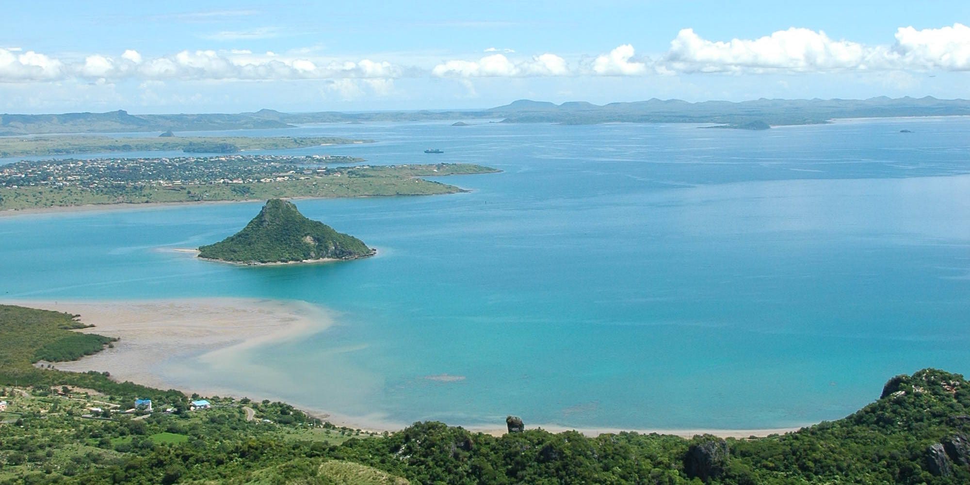
A wide turquoise bay with a cone-shaped forested islet near the shore and a low town on the far side

Nosy Be, Diego Suarez & the Northwest, Madagascar

Antsiranana

The bay of Diego Suarez with the Sugarloaf islet, seen from the Montagne des Français above Antsiranana. (Masindrano / Wikimedia Commons · CC BY-SA 3.0)

A port city at Madagascar's northern tip, still widely called Diego Suarez, set on one of the largest natural harbours in the Indian Ocean. France took the bay in 1885 and made it a naval base, leaving a grid of arcaded streets and fading colonial buildings. Today it lives on the port, fishing, trade and visitors bound for the beaches, the Emerald Sea and the forests inland.

Neighbourhoods

  • The colonial centre
    • First-time visitors
    • Historic district
    • Architecture

    The grid of streets above the harbour, laid out under French rule, with arcaded shopfronts, shuttered balconies, squares of flame trees and most of the city's restaurants, banks and hotels. Faded and salt-worn, and easy to walk in an afternoon.

    Open in Maps
  • The port and the market quarter
    • Markets
    • Local life
    • Street food

    The lower streets towards the quays, where the covered market, the fish trade, the taxi-brousse stands and the warehouses of the harbour crowd together. Busy from before dawn and the best place to eat cheaply.

    Open in Maps
  • Ramena and the bay road
    • Beaches
    • Seafood
    • Sunsets

    A fishing village with a long sandy beach about 18 kilometres north-east along the bay, with small guesthouses, grilled-fish restaurants and the boats that run to the Emerald Sea. The usual base for anyone wanting the coast rather than the city.

    Open in Maps
  • The upper town and the residential slopes
    • Quiet and residential
    • Views

    The higher ground behind the centre, with schools, offices, the university campus and houses spreading up the hillsides, and views back over the bay. Quiet, breezy and without much for visitors beyond the outlook.

    Open in Maps

Things to do

The city and the bay

  • Nosy Lonjo, the Sugarloaflandmark

    The cone-shaped forested islet standing in the middle of the bay, the city's emblem, called the Pain de Sucre in French; the commune declared it a site of traditional and ecological heritage in 1999.

    Open in Maps
  • The colonial streets and squaresneighborhood

    Arcaded commercial buildings and shuttered balconies along the rue Colbert and the squares of the upper town, laid out during the French naval period and best seen on a slow walk.

    Open in Maps
  • Antsiranana marketmarket

    The city's covered market and the streets around it, selling fish, tropical fruit, vanilla and spices, with cooked-food stalls at the edges.

    Open in Maps
  • Montagne des Françaisviewpoint

    A protected limestone ridge of dry forest on the road to Ramena, where colonial fortifications that saw fighting in 1942 stand among karst outcrops and baobabs; the walk to the summit takes about two hours and looks out over the bay.

    Open in Maps

Beaches and the sea

  • Ramena Beachbeach

    A long pale-sand beach beside a fishing village on the bay 18 kilometres from the city by surfaced road, the closest swimming and the departure point for boats.

    Open in Maps
  • The Emerald Seabeach

    A shallow turquoise lagoon behind a reef near the mouth of the bay, reached by boat from Ramena, known for its clear water and sandbanks.

    Open in Maps
  • The Three Bays and the Baie des Sakalavabeach

    A run of windswept bays on the coast east of the city, reached by track, where the steady trade winds have made kitesurfing and windsurfing popular.

    Open in Maps

Short trips from the city

  • Amber Mountain National Parkpark

    A volcanic massif of cool, misty rainforest with crater lakes, waterfalls, lemurs and very small chameleons, about 35 kilometres south above the village of Joffreville.

    Open in Maps
  • Tsingy Rougeattraction

    Spires and pinnacles of red laterite cut by the Irodo river about 60 kilometres south of the city near Sadjoavato, uncovered by landslides in the 1950s and coloured by the iron in the soil.

    Open in Maps
  • Ankarana National Parkpark

    A limestone massif about 100 kilometres south-west on the RN6, with grey tsingy pinnacles, the longest cave systems in Madagascar, underground rivers, canyons of forest and crowned lemurs.

    Open in Maps
  • Arrachart Airporttransit hub

    The city's airport, a few kilometres south of the centre, with flights to Antananarivo and other regional towns.

    Open in Maps

Seasonal events

  • Independence DayJune

    The 26 June national holiday, marked with parades through the centre, music and lantern processions the evening before.

  • The windy seasonJune to September

    Strong trade winds blow across the bay for much of the dry season, filling the eastern bays with kitesurfers and making the crossings choppy.

  • Humpback whale passageJuly to September

    Humpback whales pass along the northern coast on their migration and are watched from boats out of Ramena.

Eat and drink

Long-standing places and food districts in Antsiranana. Hours, ratings and directions come from your maps app, always current.

Antsiranana classics

  • Grilled fish at Ramenarestaurant

    Fish, prawns, crab and lobster landed by the village boats and grilled over charcoal with rice, eaten at tables set out near the beach.

    Open in Maps
  • Coconut coastal cookingrestaurant

    Chicken or fish simmered in coconut milk with rice, the standard laoka of the north coast, served in the small eating houses of the centre.

    Open in Maps
  • Sambos and street grillsmarket

    Fried pastries of Indian origin, zebu brochettes and grilled cassava sold from stalls in the market streets in the late afternoon.

    Open in Maps

Markets and drinks

  • Antsiranana marketmarket

    Fish and seafood, tropical fruit, vanilla from the Sava coast and spices, with rice and vegetables brought in from the countryside.

    Open in Maps
  • Rhum arrangé and salegy barscafe

    Cane rum steeped with vanilla, ginger or fruit, poured in bars where salegy, the fast dance music of the north, plays into the night.

    Open in Maps

Experience Antsiranana

History

The great bay at Madagascar's northern tip was known to navigators long before it had a European town on it, and the name Diego Suarez comes from sixteenth-century Portuguese voyages. The shores were Antankarana and Sakalava country, and in the seventeenth century the coast was worked by traders and by pirates who used the northern anchorages.

The modern city dates from 1885, when the treaty ending the first Franco-Merina war ceded the bay to France. The navy chose it as its principal base in the south-west Indian Ocean: dry docks, arsenals, coaling wharves and barracks were built, and a grid of streets, arcaded shops and administrative buildings rose on the high ground above the harbour, with troops and labourers drawn from Madagascar, the Comoros and France. Diego Suarez became one of the most European towns on the island, with a floating population of sailors that shaped its bars and its music.

In May 1942 British and allied forces landed near the bay and fought Vichy French troops for the harbour, in the operation that opened the Battle of Madagascar, fearing that Japan might use the base. The naval station continued after independence in 1960, and French forces withdrew between 1973 and 1975; their departure cost the city much of its livelihood. Renamed Antsiranana in 1975 — the name means the port — it has since lived on the commercial port, ship repair, fishing, a university, and a tourist trade drawn by the beaches and the parks. The old French name is still the one most people use.

Culture & Customs

Antsiranana is a port city and shows it. Antankarana and Sakalava culture is the base, with Tsimihety and highland Malagasy migrants, Comorian families, Indian and Pakistani traders known as Karana, and the descendants of French naval personnel layered on top. Islam is prominent alongside Christianity and ancestral religion, and mosques, churches and doany shrines stand within the same streets.

Royal ancestors matter in the north. The Antankarana kings' relics are kept at shrines and honoured in ceremonies, and tromba possession, in which mediums speak with the voices of dead rulers, is part of religious life rather than a spectacle. The Sugarloaf islet in the bay has been protected by the commune since 1999. Local fady vary from village to village and are explained by guides.

Salegy, the fast accordion-and-guitar dance music of northern Madagascar, is at home here, and the city's bars and street parties keep later hours than anywhere on the plateau. Women wear brightly printed lamba wraps and often masonjoany, a paste of ground wood spread on the face as sun protection and decoration. French is more commonly heard than in the interior, the northern dialect of Malagasy differs noticeably from the Merina standard, and the pace of the day is set by the heat: early mornings, a long midday pause and sociable evenings in the sea breeze.

Daily Life

About 115,000 people live in Antsiranana, which makes it the largest city of the far north. The colonial grid on the headland holds the administration, shops and restaurants; denser quarters of tin-roofed houses spread inland and up the slopes, and the fishing village of Ramena and the settlements along the bay road form a loose outer edge of the city.

The port is the anchor: commercial cargo, ship repair in the old naval dockyard, fishing boats, sugar and salt moving inland, cocoa going out, and the cruise ships that call from time to time. Around it sit trade, transport, a university and technical institutions, government offices, and the tourism business of guides, drivers, boatmen and guesthouses that has grown up since the navy left. Work is scarce and many people live by small-scale trading; the loss of the naval base is still spoken of as the moment the city's fortunes turned.

Days start early and quietly; the market is busiest before the heat, shops close for a long lunch, and the evening brings people out to the streets and the seafront air. Water and power cuts are a routine irritation, as they are across the country, and the wind — which blows hard for months and coats everything in dust in the dry season — shapes daily life as much as the rain does in summer.

Food

The city eats from the sea. Fish, prawns, crab, octopus, squid and lobster are grilled over charcoal or cooked in coconut milk and served with rice, and the simplest version — a fish from the morning's catch grilled at a table near the beach at Ramena — is the local idea of a good meal. Chicken in coconut sauce is the standard coastal laoka, and the greens-and-beef romazava of the highlands appears on most menus too.

Trade has left its mark on the cooking. The Indian and Comorian communities gave the north its sambos, the fried pastries known elsewhere as samosas, along with curries, biryani and spiced minced-meat dishes; the French left baguettes, pâtisseries and a habit of coffee in the arcaded cafés of the centre. Zebu brochettes, grilled corn and cassava are sold on the streets at dusk.

The region's crops flavour the rest: vanilla from the Sava coast to the east, cocoa and coffee from the Sambirano valley to the west, pepper, cloves and abundant fruit — mangoes, cashews, lychees in season, coconuts drunk fresh. Cane rum is the spirit, usually as rhum arrangé steeped with vanilla, ginger or fruit; Three Horses Beer is the standard beer, and tamarind and baobab-fruit juices are the everyday soft drinks.

Planning tools

Budget

Antsiranana is moderate by Malagasy standards — cheaper than Nosy Be, more expensive than the inland towns. Guesthouses and market meals cost little; the real spending goes on boat trips to the Emerald Sea, four-wheel-drive hire for the tracks to the reserves, and park entry fees with the guides that national parks require.

Daily Budget Midrange
USD 80–210 (beach hotel, boat excursions, park fees and guides, a car with driver)
Daily Budget Shoestring
USD 25–45 (guesthouse room, hotely meals, taxi-brousse and shared taxis)

Share boat and four-wheel-drive excursions with other travellers, and draw cash in the city, where the banks are.

Best Time to Visit

May to November is the main season, dry and warm, with open tracks to the parks. The trade winds blow hardest from June to September, which suits kitesurfing but makes some boat trips uncomfortable; October and November are calmer and hot. December to March is wet, with a cyclone risk and difficult roads inland.

Suggested Number of Days

Two days cover the city and the nearest coast. Four or five allow the national parks and the tsingy country to the south, where the tracks are slow and each trip takes a full day. Wind and rain can move things around, so a spare day is useful.

First Visit
2 days
With Surroundings
4–5 days

Transportation

The centre is walkable and shared taxis cover the rest of the city for a small fixed fare. Taxi-brousse minibuses run from the stations near the market to Ramena, south along the RN6 towards Ambanja, and on to Ambilobe. Anything beyond the paved roads — the tsingy, the bays east of the city — needs a four-wheel-drive with a driver, and the Emerald Sea is reached only by boat.

Agree fares before setting off, and allow a full day for any trip to the parks or the tsingy.

Airport & Station Connections

Arrachart Airport, a few kilometres south of the centre, has flights from Antananarivo and other regional towns. By road, the RN6 runs south towards Ambilobe, Ambanja and eventually Mahajanga, a journey of a day or more that is slow and rough in stretches; taxi-brousse services use it daily. Boats from Nosy Be reach the north coast, but most people travelling between the two fly or drive.

Walkability

The colonial centre is flat, laid out on a grid and pleasant to walk, with the sea breeze taking the edge off the heat; the market and the port are a short walk downhill. Pavements are broken in places and there is little shade at midday. Everything outside the city — the beaches, the bays and the parks — needs a vehicle or a boat.

Safety

The north is among the calmer parts of Madagascar for visitors, and theft in the city at night and on the beaches is the main risk. Malaria is present on the coast, sea conditions in the bay can turn quickly in the windy months, and standards among small boat operators vary. Roads inland are unlit and shared with pedestrians and carts after dark.

Leave valuables in the hotel on the beach, use licensed boat operators with life jackets, take malaria precautions, and do not travel by road at night. Check current official travel advice before travelling.

Climate

Hot all year and drier than much of the north-east, with strong winds for much of the dry season. The southern-hemisphere summer, December to February, is the rainy season, hot and humid with a cyclone risk that runs into March; the winter months of May to October are warm, dry and windy, and the air is clearest then.

Summer
hot and humid, about 25–33°C, with heavy rain and a cyclone risk from December to March
Winter
warm and dry, about 20–30°C, with strong trade winds from June to September

Local Customs

This is Antankarana and Sakalava country, with Muslim, Comorian and Indian communities long settled in the port alongside Christians, so dress in town is modest and beachwear stays at the beach. Royal ancestors are honoured at shrines called doany, and sacred places — the Sugarloaf islet among them — are subject to local fady that visitors are expected to respect.

Ask before photographing people, ceremonies or sacred sites, and follow a guide's instructions about where it is permitted to land or walk.

Common Payment Methods

The currency is the Malagasy ariary. The city has banks and cash machines, and hotels change euros and US dollars, but Ramena, the villages and the parks do not. Larger hotels and tour operators take cards; markets, taxis, boatmen and small restaurants are cash only, so small notes are worth carrying.