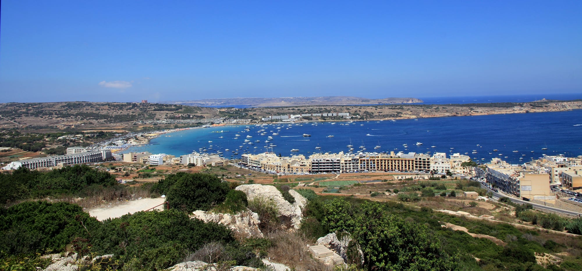
A wide blue bay dotted with moored boats, with a sandy beach at its head, apartment blocks along the shore and low ridges beyond

Malta

Mellieħa

Mellieħa Bay seen from the west side of the town. (Karelj / Wikimedia Commons · CC BY-SA 3.0)

A large village on a group of hills in north-west Malta, above Mellieħa Bay, the country's largest sandy beach. Abandoned for centuries because of corsair raids and resettled under British rule, it grew around a cave sanctuary and a 19th-century parish church, and is now a resort with beaches, nature reserves, Popeye Village and the Gozo ferry at Ċirkewwa within its limits.

Neighbourhoods

  • The village centre
    • Local life
    • Historic district
    • Best for food

    The old core on top of the hill, around the Parish Church of the Nativity of the Virgin Mary and Parish Square, with the cave Sanctuary of Our Lady and a wartime shelter tunnelled beneath. The main street holds shops and restaurants, and it is a steep, hot walk down to the beach.

    Open in Maps
  • Mellieħa Bay and Għadira
    • Beaches
    • Families

    The beach strip below the town, where Malta's largest sandy beach stretches for over a kilometre along shallow water. Behind it lies the Għadira wetland, on the site of ancient salt pans that gave the town its name.

    Open in Maps
  • Marfa Ridge and Ċirkewwa
    • Gozo ferry
    • Diving
    • Small bays

    The long ridge north of the bay, topped by the Red Tower, running out to Ċirkewwa at the northern tip of Malta. Small bays such as Armier and Paradise Bay lie along its shores, and the ferry terminal and dive sites are at its end.

    Open in Maps
  • Manikata and Golden Bay
    • Beaches
    • Countryside

    The hamlet of Manikata and the sandy bays of the west coast, including Golden Bay and Anchor Bay, where the Majjistral Nature and History Park protects the coast.

    Open in Maps
  • Selmun
    • Quiet and residential
    • Walks

    The peninsula east of the bay, with the 18th-century Selmun Palace, the wartime Fort Campbell and Mistra Bay at its edge, facing St Paul's Islands.

    Open in Maps

Things to do

Landmarks and history

  • Sanctuary of Our Lady of Mellieħalandmark

    A church that began as a consecrated natural cave, with a Byzantine-style fresco as its altarpiece, rebuilt between the late 16th and 18th centuries and long a place of pilgrimage.

    Open in Maps
  • Parish Church of the Nativity of the Virgin Marylandmark

    The large parish church on the hilltop, built in stages in the late 19th and early 20th centuries, it is said with the help of local people.

    Open in Maps
  • Mellieħa wartime shelterattraction

    A tunnel complex beneath Parish Square, dug as a bomb shelter during the Second World War and open to visitors.

    Open in Maps
  • Saint Agatha's Towerlandmark

    The Red Tower, a large bastioned watchtower built in 1647–49 on Marfa Ridge, overlooking Mellieħa Bay with views of Comino and Gozo.

    Open in Maps
  • Selmun Palacelandmark

    An 18th-century villa built by a charity for the ransoming of slaves, standing on the Selmun peninsula.

    Open in Maps

Beaches and nature

  • Mellieħa Baybeach

    Also known as Għadira Bay, the largest sandy beach in Malta, with shallow water stretching out from more than a kilometre of sand.

    Open in Maps
  • Għadira Nature Reservepark

    A brackish lake and salt marsh behind the bay, a rare permanent wetland in arid Malta, with guided tours by BirdLife Malta volunteers from November to May.

    Open in Maps
  • Golden Baybeach

    A gently sloping beach of pale sand on the west coast, once called Military Bay, with lifeguards in summer.

    Open in Maps
  • Majjistral Nature and History Parkpark

    A park declared in 2007 covering 6 kilometres of protected coast between Golden Bay and Il-Prajjet, with historic and archaeological sites.

    Open in Maps
  • Popeye Villageattraction

    The wooden film set built for the 1980 film Popeye at Anchor Bay, about 3 kilometres from the village core, now a small fun park and open-air museum.

    Open in Maps
  • Ċirkewwatransit hub

    The harbour at Malta's northern tip, with car ferries to Gozo, summer boat trips to Comino and dive sites including the wrecks of MV Rozi and the P29 patrol boat.

    Open in Maps

Eat and drink

Long-standing places and food districts in Mellieħa. Hours, ratings and directions come from your maps app, always current.

Mellieħa classics

  • Fried rabbitrestaurant

    Some of the town's restaurants serve seafood and Maltese specialities such as fried rabbit; stewed rabbit is often called the national dish.

    Open in Maps
  • Pastizzicafe

    Savoury pastries filled with ricotta or curried peas, Malta's everyday snack.

    Open in Maps

Where to eat

  • Village centre restaurantsneighborhood

    Restaurants along the main street on the hilltop and on the road down towards the bay.

    Open in Maps
  • Mellieħa Bayneighborhood

    Places to eat along the beach road at the foot of the hill.

    Open in Maps

Experience Mellieħa

History

The name Mellieħa comes from the Semitic root m-l-ħ, meaning salt, probably after the Punic-Roman salt pans at Mellieħa Bay, on a site now occupied by the Għadira Nature Reserve. People lived in caves here in antiquity, and the cave settlements continued under Byzantine rule before being abandoned in the early Middle Ages. A cave consecrated as a church became the Sanctuary of Our Lady of Mellieħa, a parish church by the early 15th century and a place of pilgrimage ever since.

The village still existed in 1436 but was abandoned soon afterwards, because the north of Malta was no longer safe from raids by Muslim corsairs, and it stayed empty through the early years of Hospitaller rule. The Knights defended the coast instead: Saint Agatha's Tower, the Red Tower, was built on Marfa Ridge in 1647–49, and the smaller Għajn Ħadid and Armier towers in 1658. The sanctuary was rebuilt from the late 16th century.

Mellieħa became a parish again in 1844, and it began to grow after the British encouraged settlement by granting leases to local people. The Parish Church of the Nativity of the Virgin Mary went up in stages in the late 19th and early 20th centuries. Just before the Second World War Fort Campbell was built at Selmun and a lookout fort on Mellieħa Hill, and a tunnel complex was dug beneath the village as a bomb shelter during the war. Since then it has also become a popular tourist resort.

Culture & Customs

The parish and its sanctuary are at the centre of local identity. The sanctuary's altarpiece is a Byzantine-style fresco of the Virgin, and local tradition links the cave church to antiquity or the early Middle Ages; a number of notable people have come here on pilgrimage over the centuries. The hilltop parish church is said to have been built with the help of the villagers themselves.

The landscape is part of the culture too. The council's area takes in the hamlets of Manikata and Selmun, and much of its coast is protected: the Majjistral Nature and History Park, declared in 2007, covers 6 kilometres of coastline that forms part of the European Natura 2000 network, and the Għadira wetland is managed with BirdLife Malta, whose volunteers lead guided visits.

Film has left its mark. Popeye Village, built as the set for the 1980 film Popeye starring Robin Williams and Shelley Duvall, survives at Anchor Bay as an open-air museum and fun park. Sailing and diving are popular, with Ċirkewwa known for its wreck dives.

Daily Life

Mellieħa had 14,232 people in July 2024, of whom 4,920 were foreign nationals — a large village by Maltese standards. Its local council also covers Manikata and forms part of the Northern Region; after the 2024 local elections Gabriel Micallef of the Nationalist Party became mayor for the 2024–2029 term.

Mellieħa is a popular destination in the summer months. The town is known for its sandy beaches, its natural environment and Popeye Village, while the hilltop centre keeps the rhythm of a parish town, with its main street, square and church, and the steep slope between the two is climbed by bus as often as on foot. Ċirkewwa, at the northern tip of the island and within the town's limits, is the departure point for the car ferries to Mġarr on Gozo, and summer boat trips to Comino and diving excursions also leave from there. To the east, the Selmun peninsula and Mistra Bay mark the edge of the town's territory, with St Paul's Islands about 80 metres offshore.

Food

Mellieħa's food is that of Malta, with a seaside emphasis. Some restaurants serve seafood and Maltese specialities such as fried rabbit; rabbit stew, stuffat tal-fenek, is often identified as the national dish, and aljotta is a fish broth with garlic, herbs and tomatoes. During Lent, fish such as lampuki and whitebait were traditionally eaten, along with stuffed artichokes, qaqoċċ mimli.

Everyday snacks are the same as across the islands: pastizzi, savoury pastries filled with ricotta or curried peas, and ħobż biż-żejt, crusty Maltese bread rubbed with tomato, drizzled with olive oil and filled with tuna, olives, capers, onion, bigilla and ġbejna, the small sheep's-milk cheese. To drink there is Kinnie, the bittersweet brown soft drink made from bitter oranges and extracts of wormwood, first produced by the Farsons brewery in 1952 and drunk straight or mixed with alcohol.

Cheese and bread connect the town to its countryside. Ġbejna is a small round cheese made from sheep's milk, salt and rennet, and most of the sheep's milk produced in Malta goes into it; it goes into bread fillings and into fritters, sfineġ, a traditional Lenten dish. Maltese bread itself is a crusty sourdough, usually baked in wood ovens.

Planning tools

Budget

Mellieħa is a resort town with accommodation from apartments to large hotels. Beaches, the nature park and the coastal walks are free; Popeye Village and some sights charge entry. Buses link the town with Valletta, Sliema and the Gozo ferry.

Daily Budget Midrange
USD 140–280 (resort hotel or apartment, restaurant dinners, Popeye Village or a boat trip, some taxis)
Daily Budget Shoestring
USD 65–100 (guesthouse or apartment room, pastizzi and simple meals, buses)

A bus pass saves money and the steep climb between the hilltop village and the beach.

Best Time to Visit

Late spring to early autumn is the beach season, with July and August the hottest and busiest months. Spring and autumn suit walks along Marfa Ridge and in the Majjistral park, and the Għadira wetland is open for guided visits from November to May.

Suggested Number of Days

Two or three days cover the town, its bays and the coast. Allow longer if Mellieħa is a beach base or a stepping stone for Gozo and Comino, which are reached from the ferry harbour at Ċirkewwa.

First Visit
2–3 days
With Surroundings
4–6 days

Transportation

The town is built on a steep hill, so the walk between the hilltop main street and the beach is hot and tiring; buses help. Buses on the Ċirkewwa route run from Valletta, Sliema and Birkirkara, and route 101 serves Popeye Village. A car makes it easier to reach the western bays.

Use the bus for the climb back up from the beach in summer.

Airport & Station Connections

Malta International Airport is at Luqa, in the south of the island; visitors continue by taxi, hire car or bus. Buses run to Mellieħa from Valletta, Sliema and Birkirkara, and the Gozo car ferry leaves from Ċirkewwa within the town's limits.

Walkability

The village centre is easy on foot, but the town is spread over a steep hillside and the beach is a long climb below it. The bays, Popeye Village and Ċirkewwa are several kilometres away and are best reached by bus or car; Popeye Village is about 3 kilometres from the village core.

Safety

Malta is one of the safer countries in Europe, with low levels of violent crime. In Mellieħa the main risks are at the sea and in the heat: the main bay is calm and shelves very gradually, but jellyfish appear, and some of the rocky coves and cliffs elsewhere are unguarded.

Swim where lifeguards are on duty in summer, watch for jellyfish, and carry water on cliff-top walks. Check current official travel advice before travelling.

Climate

Mediterranean, with long, hot, dry summers and mild, wet winters. In Valletta, on the east coast, August averages highs of about 32°C and January highs of about 16°C.

Summer
hot and dry — in Valletta, August averages highs of about 32°C and lows of about 23°C
Winter
mild and rainy — in Valletta, January averages highs of about 16°C and lows of about 10°C

Local Customs

Mellieħa is a Catholic parish town as well as a resort, and the sanctuary has been a place of pilgrimage for centuries. Modest dress is expected in the churches.

Dress modestly in the sanctuary and the parish church, and do not disturb worshippers during services.

Common Payment Methods

The currency is the euro, as everywhere in Malta.