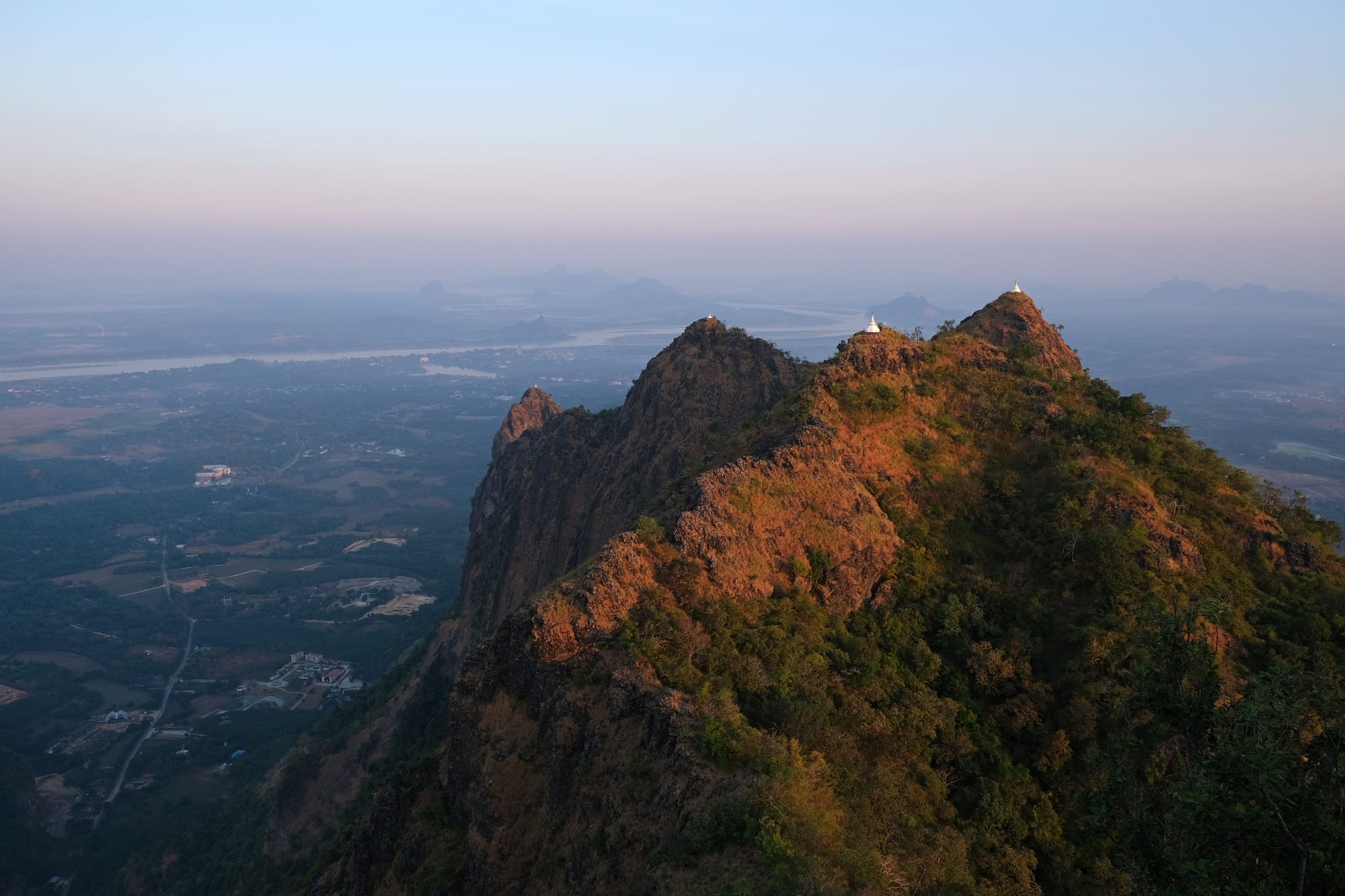
A rocky ridge with small white stupas catching early light above a hazy plain of fields, a wide river and distant limestone peaks

Shan, Mon & the Southeast, Myanmar

Hpa-An

The view from Mount Zwegabin over the plain, the Thanlwin river and the karst peaks around Hpa-An. (kallerna / Wikimedia Commons · CC BY-SA 4.0)

The capital of Kayin State, a riverside town on the Thanlwin in south-eastern Myanmar, set on a flat plain of paddy fields from which limestone peaks rise abruptly. Caves cut into those hills hold Buddhist shrines, and Mount Zwegabin stands above the town. This page is written to explain the town, not to encourage travel.

Neighbourhoods

  • Town centre
    • First-time visitors
    • Markets
    • Best for food

    The blocks around the central market and the clock tower, holding the shops, teashops, bus offices and most guesthouses. It is small enough to cross on foot in a few minutes and quiet after dark.

    Open in Maps
  • The Thanlwin riverfront
    • Views
    • Sunsets
    • Quiet walks

    The western edge of town along the river, with a pagoda and jetty, a park and food stalls looking across the water to the hills. Boats cross to villages on the far bank and ran downriver to Mawlamyine.

    Open in Maps
  • The plain towards Zwegabin
    • Countryside
    • Caves
    • Cycling

    South and east of town the road runs through paddy fields, palm trees and villages, with limestone outcrops and cave monasteries beside it and Mount Zwegabin ahead. Most of the area's sights are along these lanes.

    Open in Maps

Things to do

Peaks and viewpoints

  • Mount Zwegabinviewpoint

    The limestone peak of about 720 metres, some 8 kilometres south-east of the town, climbed by a long stairway to a summit pagoda said to enshrine a relic of the Buddha.

    Open in Maps

Cave shrines

  • Saddan Cavelandmark

    The longest cave in Kayin State, at the southern end of the Zwegabin range, holding hundreds of small Buddha statues and opening at its far end onto a lake.

    Open in Maps
  • Kyauk Ka Lat Pagodalandmark

    A temple built onto a jagged limestone pinnacle that rises from an artificial lake south of the town, with a community of monks living at its foot.

    Open in Maps
  • Kawgun Cavelandmark

    A cave temple whose walls and ceiling are covered with thousands of small Buddha votive tablets and reliefs, some carrying inscriptions in ancient Mon script.

    Open in Maps

Further afield

  • Mawlamyineneighborhood

    The Mon State capital at the river mouth, once Moulmein and the capital of British Burma, with colonial streets and hilltop pagodas.

    Open in Maps
  • Thanbyuzayat War Cemeterylandmark

    The cemetery at the western terminus of the Thailand–Burma railway, holding the graves of Allied prisoners of war who died building it.

    Open in Maps
  • Kyaiktiyo Pagodalandmark

    The Golden Rock, a gilded boulder balanced on a cliff edge at the top of a mountain in Mon State, one of the country's most revered pilgrimage sites.

    Open in Maps

Seasonal events

  • Karen New YearDecember or January

    A national holiday marking the Karen new year, celebrated in Kayin State with processions, traditional dress, and the don and bamboo dances.

  • Thingyan water festivalApril

    The Burmese new year, several days of water throwing, monastery visits and merit-making at the hottest time of the year.

  • Thadingyut festival of lightsOctober

    The end of the Buddhist Lent, when pagodas, monasteries and houses are lit with candles and lamps and elders are paid respect.

Eat and drink

Long-standing places and food districts in Hpa-An. Hours, ratings and directions come from your maps app, always current.

Where to eat in Hpa-An

  • The central marketmarket

    The town's market sells river fish, vegetables from the plain, fruit, fermented fish and shrimp pastes and cooked snacks from early morning.

    Open in Maps
  • Curry and noodle shops in the centreneighborhood

    Small shops around the market serve Bamar and Karen curries with rice and a tray of vegetables, and noodle dishes in broth at breakfast.

    Open in Maps
  • Riverside stalls on the Thanlwinneighborhood

    Stalls and simple restaurants along the embankment sell grilled fish, fritters and drinks in the late afternoon, with the hills across the water.

    Open in Maps

Experience Hpa-An

History

The plain around Hpa-An was Mon country long before it was Karen. The Mon kingdom centred on Thaton, north-west of here, was the earliest known civilisation of lower Burma, and the votive tablets and carvings packed into the caves near the town were left by Mon donors over several centuries, some of them dating from the period before Anawrahta of Bagan conquered Thaton in 1057. The limestone hills, riddled with caves and easy to defend, drew hermits and monks throughout that time.

Karen migration into the hills and plains of the southeast continued over centuries, and by the colonial period the Karen were the dominant population here. Britain took Tanintharyi after the First Anglo-Burmese War of 1824 to 1826 and the rest of lower Burma in 1852, and American Baptist missionaries converted a substantial Karen minority to Christianity, opening schools that produced much of the Karen elite. Hpa-An remained a modest river town, trading rice, teak and rubber down the Thanlwin to Moulmein.

After independence the Karen National Union took up arms in 1949, beginning one of the world's longest insurgencies, and the countryside around the town has lived with that conflict ever since. Hpa-An became the capital and largest city of Kayin State and grew as its administrative centre, with universities and a market serving the surrounding townships. From the 1990s it attracted travellers heading between Yangon and the Thai border; since the 2021 coup the southeast has again been one of the main theatres of the war.

Culture & Customs

Hpa-An is the cultural centre of the Karen, or Kayin, a people made up of related groups including the Sgaw and Pwo, each with its own language. Religion is mixed: most Karen here are Theravada Buddhist, a significant minority are Christian, and older animist practice survives in village ritual. Monasteries, churches and cave shrines all belong to the same landscape, and pilgrimage to the caves and to the summit of Zwegabin is a normal part of religious life.

The Karen New Year, a public holiday falling in December or January, is the main public celebration, marked with processions, woven tunics and skirts in red and white, and the don dance and bamboo dance, in which dancers step between poles clapped together in rhythm.

Weaving is the best-known local craft: hand looms produce the striped and embroidered tunics worn at festivals, and the work is sold in the town's market. Manners follow the wider Burmese pattern — modest dress, quiet voices, elders greeted first, shoes removed at religious sites — and, as elsewhere in the country, political conversation is avoided with strangers. Many families here have relatives working in Thailand or living in camps along the border, and that shapes much of what people discuss among themselves.

Daily Life

About 75,000 people lived in Hpa-An at the 2014 census, with many more in the villages of its township across the plain; it is the largest city in Kayin State. It is a government and market town: the state administration, universities, hospitals and the wholesale trade in rice, rubber, fruit and vegetables from the surrounding countryside all sit here, and the roads through it carry traffic between Yangon, Mawlamyine and the east.

Farming sets the rhythm outside town — paddy fields worked through the monsoon, rubber tapping, betel and fruit gardens — while in town the market opens before dawn, offices and schools run through the morning, and the afternoon heat empties the streets until evening. Motorcycles are the way almost everyone travels, and houses are low, of brick, wood and bamboo, with trees and palms between them.

Labour migration is central to the local economy. Very large numbers of Karen work in Thailand, legally and otherwise, and the money they send home supports whole villages; others have lived for decades in camps on the Thai side of the border. Since 2021 fighting in the countryside has displaced many thousands more, fuel and food prices have risen sharply, and electricity, mobile signal and internet are cut for long periods. Checkpoints and curfews are part of ordinary movement.

Food

Cooking here blends Karen, Mon and Bamar traditions with the produce of a hot, wet plain. Rice is the centre of every meal, served with a curry of fish, pork or chicken cooked in oil with garlic, turmeric and chilli, a clear soup, and a tray of raw and steamed vegetables with ngapi yay, the thin dip of fermented fish or shrimp paste that gives southern food its salty depth. Sour curries and soups flavoured with tamarind or lime are common.

The Thanlwin and the paddy fields supply freshwater fish, which is grilled over charcoal, fried, or fermented and dried for the market. Karen village cooking uses bamboo shoots, jackfruit, banana flower, wild greens and a good deal of chilli, and dishes are often steamed in banana leaf or cooked in a length of green bamboo. Mon influence from downriver shows in sweets made with palm sugar, coconut and rice flour.

Breakfast is mohinga, the fish and rice-noodle soup eaten across the country, or noodles with coconut broth, bought from a stall or a teashop. Teashops serve strong tea with condensed milk and fried snacks from before dawn, and the market sells tropical fruit from the surrounding orchards: durian, mangosteen, rambutan, jackfruit and pomelo in season. Betel is chewed widely here, and stalls selling leaves, lime paste and areca nut stand on most streets.

Planning tools

Budget

Hpa-An was among the cheapest stops in the country: guesthouses, noodle shops, bicycle hire and a shared tuk-tuk or motorbike for the caves cost very little. Since 2021 prices have risen with inflation and fuel costs, and many hotels and operators have closed.

Daily Budget Midrange
USD 70–160 (hotel, private car or guide, boat hire, entry and camera fees)
Daily Budget Shoestring
USD 25–45 where travel is possible (guesthouse, noodle shops, shared transport to the caves)

Entry and camera fees at the caves and pagodas go to the authorities; carry clean US dollar notes and kyat in cash, as card access does not work.

Best Time to Visit

In climate terms, November to February, when the southeast is dry and warm, the caves are easy to reach and the paths up Zwegabin are not slippery; the Karen New Year falls in December or January. Security is the deciding factor: fighting in Kayin State and on the roads through it has continued since 2021.

Suggested Number of Days

Two or three days is the usual length of stay, with the caves and peaks on the plain reached from the town. Four or five allows the river mouth and the pilgrimage sites further north, and any journey depends on whether the roads are open.

First Visit
2–3 days
With Surroundings
4–5 days

Transportation

The town is small and covered on foot or by bicycle. The caves, monasteries and karst peaks on the plain are spread over 10 to 30 kilometres and are reached by hired motorbike, motorcycle taxi or a tuk-tuk taken for the day. Buses run west to Yangon and south to Mawlamyine, and boats worked the Thanlwin downriver.

Roads in Kayin State are frequently closed by fighting, and the Thai border crossings are unreliable; never travel towards Myawaddy or Shwe Kokko.

Airport & Station Connections

Most people arrive by road: Mawlamyine is about an hour south and Yangon six to seven hours west by bus in normal conditions, with express buses from the town to both. A river boat once ran down the Thanlwin to Mawlamyine. The town's own airport is closed to civilian aircraft, and the road east to the Thai border at Myawaddy should not be used.

Walkability

The centre is flat, compact and walkable, from the market to the riverfront in a few minutes, and the embankment is a pleasant evening walk. There is little shade in the middle of the day, footways are uneven, and everything outside town needs transport. The climb up Zwegabin is a long stairway of several hours in heat and humidity.

Safety

Kayin State is one of Myanmar's main war zones. Fighting between the army and ethnic armed groups has brought air strikes, landmines and mass displacement, control of towns has shifted, and the Thai border near Myawaddy is a hub for online-scam compounds that traffic foreigners. Consular help is limited, communications are cut for long periods and roads close without warning.

Do not travel against official advice, stay away from border areas, and treat any job offer leading to the Thai border as a trafficking risk. Check current official travel advice before travelling.

Climate

Hot and humid all year, with one of the heaviest monsoons in the country. Rain falls from about May to October and can be relentless in July and August, while November to February is dry and slightly cooler and March to May is very hot.

Summer
hot and humid, about 30–38°C before the rains, then persistent heavy monsoon rain from May to October
Winter
dry and warm, generally about 25–32°C by day with cooler mornings and clear views of the peaks

Local Customs

Kayin State's Karen population is Buddhist, Christian and animist, and churches stand beside monasteries in the town. Shoes and socks come off at pagodas and in caves used as shrines, shoulders and knees are covered, and cave floors can be wet and sharp underfoot. Longyi are everyday dress and thanaka is worn on the face.

Tipping is not customary but small amounts are appreciated. Do not photograph soldiers, police, checkpoints or military buildings, and ask before photographing people or monks.

Common Payment Methods

The currency is the Myanmar kyat. This is a cash economy: foreign cards rarely work, ATMs are unreliable and international banking has been disrupted since 2021, so clean, undamaged US dollar notes are the usual fallback. Exchange rates differ widely between official and market rates.