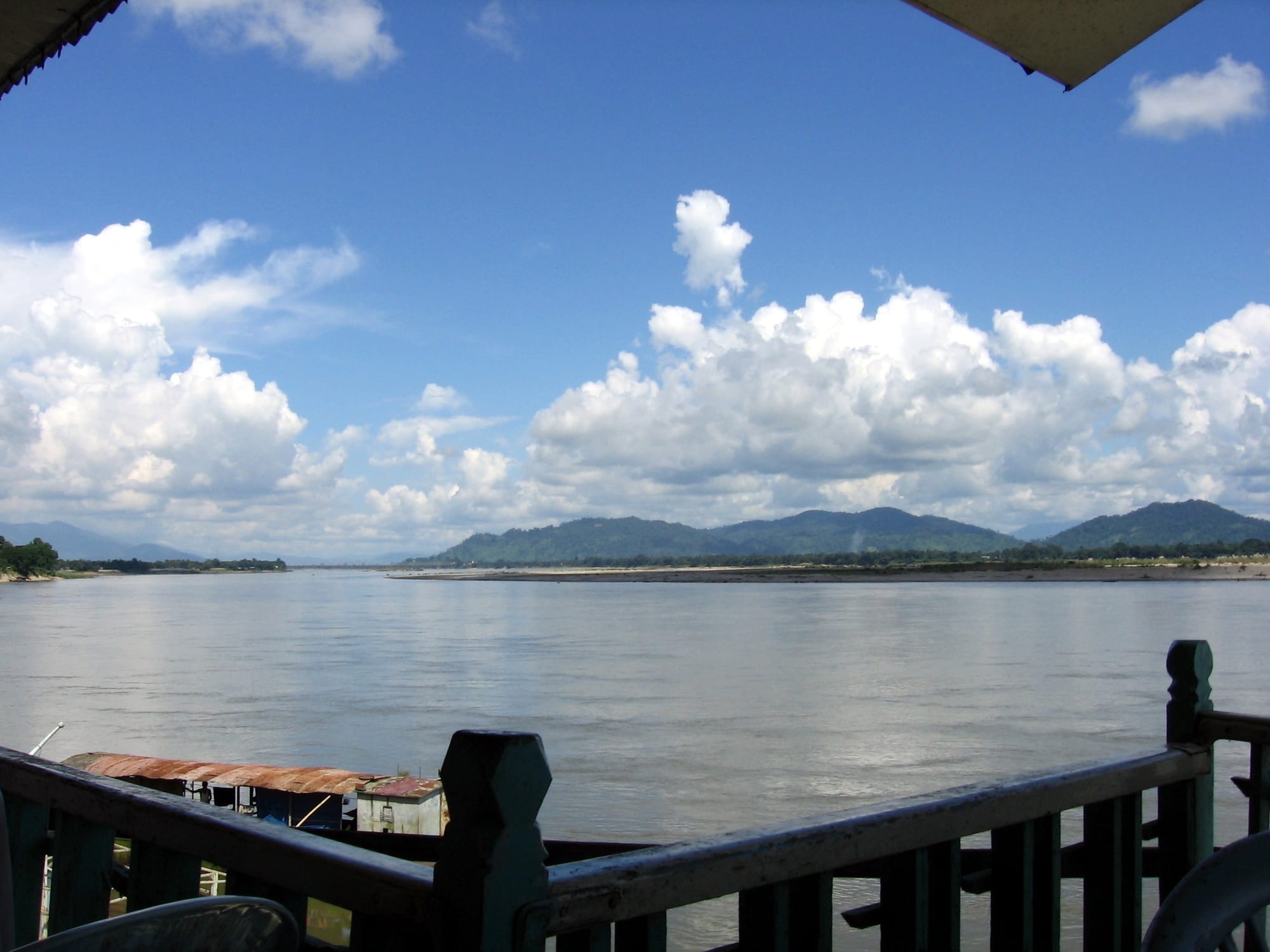
A wide grey-blue river seen from a riverside terrace railing, with sandbanks and low green hills under a bright cloudy sky

Kachin, Sagaing & the North, Myanmar

Myitkyina

The Ayeyarwady River seen from the riverfront at Myitkyina. (Colegota / Wikimedia Commons · CC BY-SA 2.5 es)

The capital of Kachin State, on the upper Ayeyarwady in Myanmar's far north, about 40 kilometres below the confluence where the river is held to begin. It grew as the last stop of the railway from Mandalay, was fought over in the Second World War, and is the centre of Kachin Christian and cultural life. This page is written to explain the city, not to encourage travel.

Neighbourhoods

  • Town centre
    • First-time visitors
    • Markets
    • Close to public transport

    The grid of streets around the central market and the railway station, where the shops, teashops, banks and guesthouses are concentrated. It is the busiest part of the town and everything in it is within a short walk.

    Open in Maps
  • The riverfront
    • Views
    • Quiet walks
    • Sunsets

    The embankment and jetties along the Ayeyarwady on the town's eastern edge, where boats load and small restaurants and tea stalls look across the water to the hills. Pagodas and open ground line parts of the bank.

    Open in Maps
  • Waingmaw and the east bank
    • Local life
    • Quiet and residential

    The separate township directly across the river from Myitkyina, reached by bridge. It is smaller and more rural, with farmland, villages and markets serving the surrounding countryside.

    Open in Maps

Things to do

In the town

  • Myitkyina Universityattraction

    The main university of Kachin State, on the edge of the town, drawing students from across the far north.

    Open in Maps
  • Myitkyina Airporttransit hub

    The small domestic airport on the western side of town, historically the fastest link to Mandalay and Yangon.

    Open in Maps
  • Waingmawneighborhood

    The township on the opposite bank of the Ayeyarwady, a rural counterpart to the town with its own market.

    Open in Maps

The river and the confluence

  • Myitsonelandmark

    The confluence north of the town where the Mali and N'Mai rivers join to form the Ayeyarwady, a sacred place for the Kachin and the site of a Chinese-backed dam project suspended in 2011.

    Open in Maps

Short trips from the town

  • Indawgyi Lakepark

    The largest lake lying entirely within Myanmar, about 110 kilometres south-west of the town, a wetland of fishing villages and waterbirds surrounded by forested hills.

    Open in Maps
  • Indawgyi Wildlife Sanctuarypark

    The protected wetland and forest around the lake, gazetted in 2004, important for waterbirds and recognised as a biosphere reserve, a Ramsar site and an ASEAN Heritage Park.

    Open in Maps
  • Mogaungneighborhood

    An old trading town on the Mandalay–Myitkyina railway west of the city, on the way to the jade-mining country around Hpakant.

    Open in Maps

Seasonal events

  • Manau festivalJanuary

    The great Kachin festival, a mass dance in columns around tall painted poles, held in Myitkyina around Kachin State Day.

  • Thingyan water festivalApril

    The Burmese new year, marked across the country with several days of water throwing, visits to monasteries and merit-making.

  • ChristmasDecember

    Widely observed by the state's large Christian minority, with church services, carol singing and family feasts in the town and surrounding villages.

Eat and drink

Long-standing places and food districts in Myitkyina. Hours, ratings and directions come from your maps app, always current.

Where to eat in Myitkyina

  • The central marketmarket

    The town's main market, where river fish, hill vegetables, bamboo shoots, dried and fermented foods and cooked snacks are sold.

    Open in Maps
  • Kachin kitchens in the town centreneighborhood

    Small restaurants around the centre serving Kachin dishes — rice with beans and vegetables, pounded chilli relish, bamboo shoots and grilled meat.

    Open in Maps
  • Teashops and riverside stallsneighborhood

    Teashops serve sweet milk tea, fried snacks and noodles from early morning, and simple stalls along the embankment look over the water.

    Open in Maps

Experience Myitkyina

History

The town's Jinghpaw and Burmese names both refer to its position on the great river: Myitkyina stands on the west bank of the Ayeyarwady a little below Myitsone, the confluence of the Mali and N'Mai rivers where the Ayeyarwady is traditionally held to begin. For centuries this was a river and caravan crossing on the routes between upper Burma, the Kachin hills and Yunnan, with jade and amber coming down from the mines to the west.

Britain annexed Upper Burma in 1885 and campaigned into the Kachin hills over the following years, governing them separately from Burma proper as Frontier Areas. The railway from Mandalay was pushed north to Myitkyina under British rule, making it the country's northernmost railway terminus, and the town became the administrative and trading centre of the far north, a garrison and mission station at the end of the line. American Baptist missionaries, at work here from the late nineteenth century, converted much of the Kachin population and gave Jinghpaw a written form in the Latin alphabet.

In the Second World War the town's airfield and railhead made it a prize on the supply route to China. Japanese forces took it in 1942, and Allied and Chinese troops retook it in 1944 after a siege lasting several months, which destroyed much of the town; the Ledo Road from India was pushed through to link up with the route east soon afterwards. Kachin leaders signed the Panglong Agreement with Aung San in 1947, but the Kachin Independence Army took up arms in 1961, and the town has lived with the consequences of that long conflict ever since.

Culture & Customs

Myitkyina is the cultural capital of the Kachin, a group of related peoples that includes the Jinghpaw, Lisu, Rawang, Lhaovo, Lachik and Zaiwa, each with its own language and dress. Most are Christian, largely Baptist and Catholic, and church life shapes the week: choirs, youth groups and church-run schools and clinics are central institutions, and Christmas and Easter are the biggest family occasions of the year.

The town's great public event is the Manau, a mass dance held around tall painted poles in January, near Kachin State Day, in which lines of dancers in red and black woven dress follow leaders in hornbill-feather headdresses. Kachin women's woven skirts, silver ornaments and the dance's drums and gongs are the images most associated with the state. Older animist practice survives behind much of the ceremony, and traditional law and clan obligation still matter in village life.

The town is not only Kachin. Bamar, Shan, Chinese and Nepali-descended families have lived here for generations, Buddhist pagodas stand along the river, and Burmese is the shared language of business and administration alongside Jinghpaw. Identity here is bound up with a long struggle over the place of the Kachin within the state, and local churches, language and organisations are part of daily loyalty. Visitors are expected to be discreet: politics is not discussed openly with strangers.

Daily Life

About 150,000 people live in Myitkyina, which makes it the largest town in the far north. It is an administrative centre, with government offices, a university, hospitals and the headquarters of church denominations, and a trading town, where goods from China and central Myanmar are broken up for the surrounding hills. Jade and amber from the mines to the west, gold, timber and farm produce all pass through, and much of that trade runs across the Chinese border.

Daily life is lived early: markets open before dawn, teashops fill soon after, and offices and schools start early and finish in the afternoon heat. Most housing is single-storey, in compounds around the centre and along the roads out of town, and motorcycles are the way most people move. The surrounding countryside grows rice, maize and vegetables, and fish come from the river.

Since 2021 the rhythm has been shaped by war in the countryside. Large numbers of displaced people from the surrounding townships shelter in camps run by churches and aid groups, electricity, mobile signal and internet are cut for long periods, and prices of fuel and food have risen sharply. Kachin State also carries one of the country's heaviest burdens of heroin and methamphetamine use, and church-led campaigns against drugs have been a prominent part of public life for years. Many young people have left for Yangon, China, Thailand or further afield.

Food

Kachin cooking is one of the most distinctive in Myanmar and is best known in Myitkyina's restaurants. It is built on cold-climate and forest ingredients: rice, potatoes, bamboo shoots, foraged herbs and greens, river fish and game. Shat jam, boiled rice mixed with beans, vegetables, mushrooms and fried onion, is the everyday staple and is often served on a banana leaf. Japhtu, a pounded relish of chilli, garlic and herbs, goes beside almost everything, and salted or fermented bamboo shoots give many dishes their sour edge.

Meat and fish are usually grilled, or steamed in banana leaf or inside a length of green bamboo with herbs and a little rice — a method used for chicken, pork and river fish alike. Kachin food uses less oil than Bamar cooking and more fresh herb and chilli, and a meal is typically a spread of small dishes shared around rice rather than a single curry.

The town's other kitchens reflect its mixed population. Bamar curries, mohinga noodle soup and laphet thoke tea-leaf salad are everywhere, Shan khauk swe rice noodles are a common lunch, and Chinese-style stir-fries and noodle shops reflect the trade with Yunnan. Teashops open before dawn for sweet milk tea, fried dough sticks and steamed buns, and remain the place where news is exchanged. Home-brewed rice liquor and rice beer are part of village celebration, and the market sells dried fish, pickles and hill fruit in season.

Planning tools

Budget

Myitkyina was always cheap to stay in and expensive to reach: guesthouses, market food and shared transport cost very little, while the flight from Mandalay or Yangon, permits and a guide made up most of a budget. Since 2021 fuel, food and transport prices have risen sharply, and normal tourist spending is not possible in much of Kachin State.

Daily Budget Midrange
USD 80–200 (flight to Myitkyina, permits, guide and driver)
Daily Budget Shoestring
USD 25–45 where travel is possible (basic guesthouse, market food, shared transport)

Costs are unpredictable, banking is unreliable and remote areas required permits and licensed guides even before 2021; under current conditions the far north should be treated as closed to visitors.

Best Time to Visit

In climate terms, November to March, when the roads are dry and the mountains are clear, and the Kachin Manau festival falls in January. The weather is secondary: fighting across Kachin State since 2021 has put the far north beyond safe reach.

Suggested Number of Days

The town itself is small and a day or two covers it. Three or four days would allow for the river upstream and the long journey out to the lake country, both of which depend entirely on whether the roads are open.

First Visit
1–2 days
With Surroundings
3–4 days

Transportation

Distances are long and roads poor. Myitkyina has an airport, and the railway from Mandalay takes the best part of a day or more. Within the town, motorcycle taxis, three-wheelers and bicycles cover the short distances, and boats work the river. Much of the surrounding road network runs through contested territory, with checkpoints, closures and landmines.

Treat all overland movement in the north as unsafe; the land border with China is not a reliable exit. Check current conditions before moving anywhere outside the town.

Airport & Station Connections

Myitkyina Airport sits on the edge of the town, a few kilometres from the centre, and flights to Mandalay and Yangon were the usual way in. The railway from Mandalay ends here after a slow journey of a day or more through Sagaing Region and the Kachin hills, and roads run south towards Bhamo and west towards Mogaung. Air and rail services are irregular.

Walkability

The centre is flat, compact and easily walked: the market, the station, the shops and the riverfront are within a few blocks of each other. Pavements are uneven and rain is heavy from May to October, and anything beyond the centre — the university, the airport, the bridge — is a ride rather than a walk.

Safety

Kachin State is one of the most dangerous parts of Myanmar. The countryside around the town has seen sustained fighting since 2021, with air strikes, landmines and very large numbers of displaced people, control of towns and roads has changed hands, and consular help is effectively unavailable. Communications are cut for long periods and movement is controlled by checkpoints.

Do not travel to this region; if already in Myanmar, stay out of conflict areas and keep in contact with the relevant embassy. Check current official travel advice before travelling.

Climate

Myitkyina lies in the wetter, cooler north, and takes the full monsoon from about May to October. The dry season from November to March brings clear skies, warm days and cool nights, with the mountains visible to the north and east.

Summer
hot and humid before the rains, generally around 30–35°C, then long heavy monsoon rain from May to October
Winter
dry and clear, with pleasant days around 25°C and cool nights, and snow on the Himalayan peaks far to the north

Local Customs

About a third of Kachin State is Christian, most of them Kachin, and churches anchor many neighbourhoods, while Buddhism is the religion of the state's majority and pagodas and a Bamar, Shan and Chinese population are part of the town as well. Shoes and socks come off at pagodas and in monasteries, and shoulders and knees are covered at religious sites. Elders are greeted first and gifts and money are passed with the right hand.

Tipping is not customary but small amounts are appreciated. Do not photograph soldiers, police, checkpoints or military buildings, and ask before photographing people, particularly in displacement camps.

Common Payment Methods

The currency is the Myanmar kyat. This is a cash economy: foreign cards rarely work, ATMs are unreliable and international banking has been disrupted since 2021, so clean, undamaged US dollar notes are the usual fallback. Exchange rates differ widely between official and market rates.