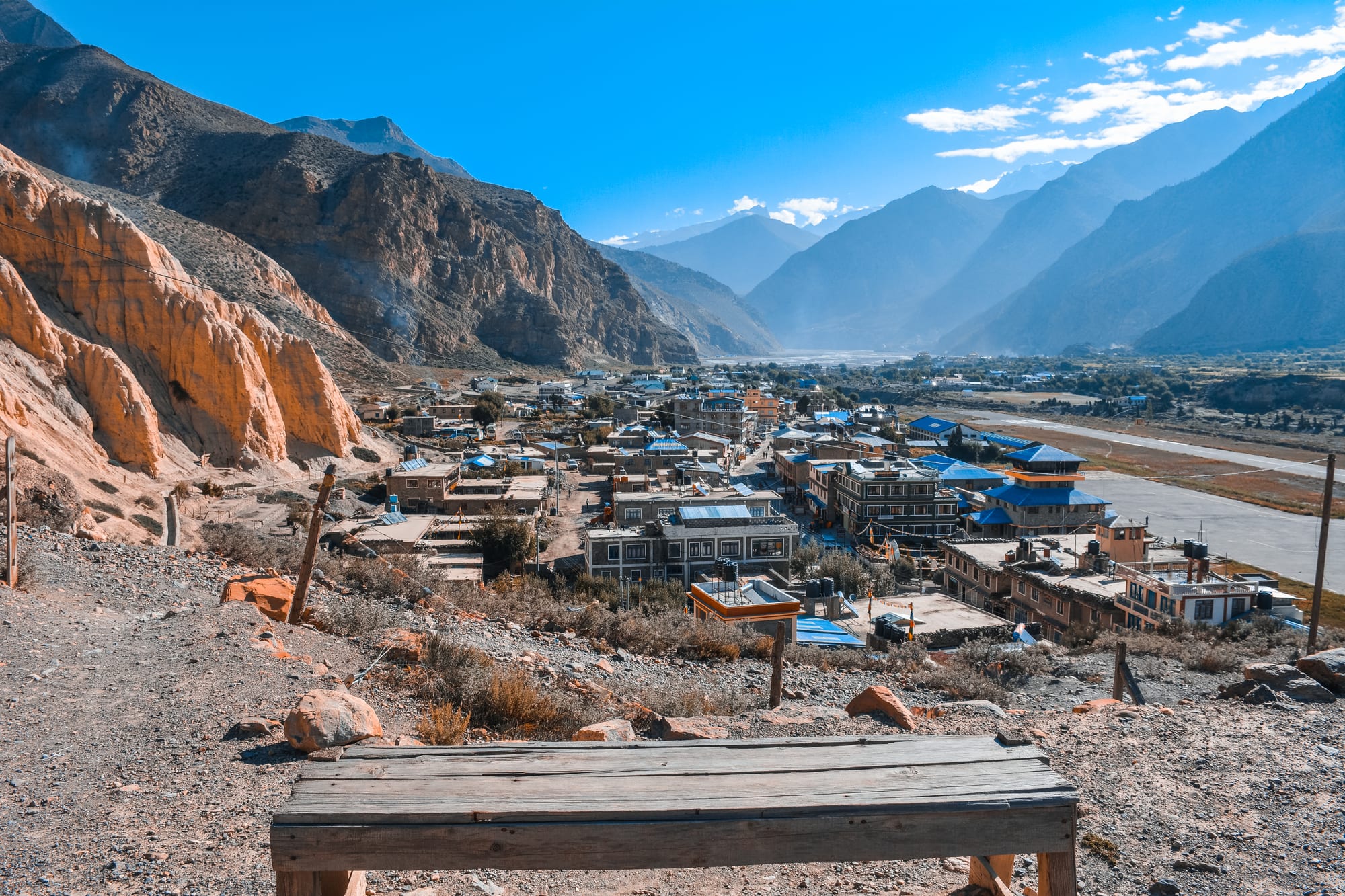
Flat-roofed blue and white buildings of a valley town beside a long airstrip, below bare cliffs and hazy mountain ridges

Pokhara & the Annapurna Region, Nepal

Jomsom

Jomsom and its airstrip on the floor of the Kali Gandaki valley in Mustang district. (Utsab Raj Giri / Wikimedia Commons · CC BY-SA 4.0)

The administrative centre of Mustang district, strung along both banks of the Kali Gandaki at about 2,700 metres between the walls of Dhaulagiri and Annapurna. Once a halt on the salt-and-grain route to Tibet, it is now a Thakali trading town with an airstrip, a jeep road and a steady traffic of trekkers and pilgrims heading up to Muktinath and into Mustang.

Neighbourhoods

  • The bazaar and airstrip
    • First-time visitors
    • Lodges and food
    • Transport

    The long main strip on the east bank, running beside the runway of Jomsom Airport. Most lodges, Thakali kitchens, trekking shops, the bank and the jeep stands are here, and the street empties in the afternoon when the valley wind rises.

    Open in Maps
  • Across the bridge
    • Quiet and residential
    • Traditional houses

    The older settlement on the west bank of the Kali Gandaki, reached by the road bridge. Flat-roofed stone and mud houses stacked with firewood, small fields and a quieter set of guesthouses sit below the dry hillside.

    Open in Maps
  • Thini and the side valley
    • Walks
    • Local life

    An old village on the slope north-east of the airstrip, among some of the highest irrigated fields in the valley, reached by an easy walk from the bazaar. The lane up towards it passes chorten gateways and prayer walls and gives the standard view back over the town.

    Open in Maps

Things to do

In and around the town

  • Jomsom Airporttransit hub

    A short runway laid along the valley floor, used by early-morning flights from Pokhara before the daily wind closes it.

    Open in Maps
  • Kali Gandaki Gorgelandmark

    The valley the town sits in, cut between the Dhaulagiri and Annapurna massifs and often described as one of the deepest gorges on earth; its gravel bed is a source of shaligram, the black ammonite fossils revered by Hindus.

    Open in Maps
  • Annapurna Conservation Areapark

    Nepal's largest protected area, which takes in the whole of the Kali Gandaki valley around Jomsom and issues the permit trekkers need here.

    Open in Maps

Pilgrim sites and villages up the valley

  • Muktinathlandmark

    A temple complex about 20 kilometres north-east and some 1,000 metres higher, sacred to Hindus as one of the 108 Divya Desam shrines of Vishnu and to Buddhists as a place linked to Padmasambhava, with water spouts and a natural gas flame at the adjoining Jwala Mai temple.

    Open in Maps
  • Kagbenineighborhood

    A compact mud-brick village at the junction of the Kali Gandaki and the Jhong valley, regarded as one of the oldest in the Himalaya and the last settlement before the restricted area of Upper Mustang.

    Open in Maps
  • Upper Mustangattraction

    The dry, Tibetan-Buddhist country north of Kagbeni, a restricted area of eroded cliffs, cave dwellings and painted monasteries entered on a special permit with a licensed guide.

    Open in Maps

Villages down the valley

  • Marphaneighborhood

    A whitewashed Thakali village of paved lanes and flat roofs a short way south, known across Nepal for its apple orchards, apple brandy and dried fruit.

    Open in Maps
  • Tukucheneighborhood

    A former customs post and trading village further down the gorge, where Thakali merchant houses recall the days when Tibetan salt was exchanged here for grain from the hills.

    Open in Maps

Mountains and passes

  • Thorong Laviewpoint

    The pass at about 5,400 metres crossed on the Annapurna Circuit, which trekkers descend from towards Muktinath and Jomsom.

    Open in Maps
  • Nilgiri Himalviewpoint

    The wall of snow peaks east of the town, visible from the bazaar on clear mornings.

    Open in Maps
  • Dhaulagiriviewpoint

    The world's seventh-highest mountain, rising west of the gorge and seen from the trail and the road south of Jomsom.

    Open in Maps

Seasonal events

  • Yartunglate summer

    A horse-racing and archery festival of the Baragaun villages around Muktinath, kept at the end of the summer with riding, dancing and feasting.

  • Janai Purnima pilgrimage to MuktinathAugust

    The busiest days of the Hindu pilgrimage season, when large numbers of pilgrims pass through Jomsom on the way up to the shrine.

  • LosarFebruary or March

    The Tibetan new year, marked in the Buddhist villages of the upper valley with monastery rituals, family visits and dancing.

Eat and drink

Long-standing places and food districts in Jomsom. Hours, ratings and directions come from your maps app, always current.

Jomsom classics

  • Thakali setrestaurant

    The refined daal bhaat of the Kali Gandaki, served on compartmented plates — rice or buckwheat dhido, black lentils, spiced greens, potatoes, pickle and often mutton or dried meat.

    Open in Maps
  • Marpha apple brandy and dried fruitmarket

    Apples from the orchards a few kilometres down the valley are pressed for juice, dried, made into jam and distilled into the brandy sold all along the trail.

    Open in Maps

The bazaar

  • Jomsom bazaar lodges and teashopsneighborhood

    The strip beside the airstrip, where lodge kitchens serve momo, thukpa, buckwheat pancakes, sea buckthorn juice and salty butter tea alongside a traveller's menu.

    Open in Maps

Experience Jomsom

History

The town's name is usually traced to Dzong-Sampa, "new fort", and the settlement grew where the Kali Gandaki valley widens enough for fields and a crossing. The gorge, cut between the Dhaulagiri and Annapurna massifs, has carried trade between India and Tibet for centuries: salt and wool brought down from the Tibetan plateau, grain, sugar and cloth carried up from the Nepalese hills and the Indian plains. The Thakali people of the Thak Khola, the upper part of the gorge around Jomsom, Marpha and Tukuche, ran that traffic and grew prosperous on it, and the merchant houses of these villages date from those years.

The trade collapsed after 1959, when the border with Tibet was closed to the old caravans and cheap Indian sea salt reached the hills by road. Many Thakali families moved down to Pokhara, Butwal and Kathmandu, where they opened the hotels and restaurants that carried their cooking across the country. Jomsom kept its position because the government made it the administrative headquarters of Mustang district, and an airstrip on the valley floor tied it to Pokhara.

Trekking replaced trade. From the 1970s the Annapurna Circuit brought walkers down from the Thorong La into the town, and Hindu pilgrimage to Muktinath grew alongside it. The Annapurna Conservation Area was established over the whole valley in the 1980s. The biggest recent change has been the road: a jeep track pushed up the gorge from Beni and on towards Muktinath and Lo Manthang, which shortened journeys, lowered the price of goods and took much of the walking traffic off the valley floor.

Culture & Customs

Jomsom sits on a cultural boundary. South of it the valley is Thakali, a people whose religion blends Buddhist practice with Hindu observance and clan deities, and whose villages of whitewashed flat-roofed houses are laid out around paved lanes and irrigation channels. North of Kagbeni the culture is plainly Tibetan, and Lo, the old kingdom of Upper Mustang, keeps its own dialect and monasteries. Both traditions meet in the bazaar, along with Nepali-speaking officials, soldiers and shopkeepers from the hills.

Thakali social life has long run on rotating credit and labour associations among households, which financed trade and still underpin village affairs. Village assemblies, communal irrigation and collective work on trails and canals matter here more than in the lowlands, because the environment allows little slack. Houses are built to the same pattern — thick stone walls, a walled courtyard, and a flat roof stacked with firewood, which is both winter fuel and a display of a family's standing.

Ritual life follows the mountain calendar. Monastery festivals, Losar at the Tibetan new year and the late-summer Yartung horse festival are the fixed points, while the Hindu pilgrim season brings a different crowd up the same road to Muktinath. Visitors are expected to walk clockwise around chortens and mani walls, to remove shoes in temples and to ask before photographing people at prayer.

Daily Life

Jomsom is a small town, the centre of Gharpajhong rural municipality, whose population was under 4,000 at the last census, but as the district headquarters it holds offices, a hospital, a bank, secondary schools and a police and army presence that serve a much larger area of Mustang. The population swells in the trekking and pilgrimage seasons and thins in winter, when many families move down to Pokhara or Kathmandu, where they often keep a second home and a business.

The economy runs on three things: lodging and food for trekkers and pilgrims, government employment, and apples. Orchards in Marpha and neighbouring villages supply fruit, juice, jam and brandy that are sold the length of the valley, and buckwheat, barley, potatoes and vegetables are grown on irrigated terraces. Remittances from relatives abroad support many households, as they do across Nepal.

The day is organised around the wind. Flights, jeep departures and much of the heavy work happen in the still hours after dawn; by late morning the gorge is blowing hard and the street quiets. Water comes from glacier-fed channels, electricity from small hydropower on the side streams, and almost everything else arrives by jeep. Current concerns are the ones the road brought: dust and erosion, competition from villages newly reachable by vehicle, the drying of springs, and how far the valley should change to keep visitors coming.

Food

Jomsom is the home ground of Thakali cooking, the best-known regional cuisine in Nepal. The Thakali set is a carefully composed daal bhaat: rice or dhido, a thick porridge of buckwheat or barley flour, served with black lentil daal, seasonal greens, potatoes cooked with local spices, a sharp pickle, and usually mutton, or dried meat, with generous refills. It is eaten from compartmented brass or steel plates and is on every lodge menu in the valley.

Buckwheat is the crop that defines the high fields, and it appears as pancakes, bread and dhido. Dried meat, sukuti, is fried with chilli and onion; thukpa, a noodle soup, and momo dumplings come from the Tibetan side of the culture, along with butter tea salted rather than sweetened. Yak and its cross-breeds provide cheese and curd higher up the valley.

Apples are the town's other signature. Marpha's orchards produce fresh fruit in autumn and, year round, dried rings, jam, cider vinegar, juice and the apple brandy that lodges pour in the evening. Sea buckthorn from the riverbanks is pressed into a sharp orange juice sold as a local speciality, and raksi, the distilled grain spirit made throughout Nepal, is served warm in winter.

Planning tools

Budget

Jomsom is more expensive than the lowlands, because almost everything is carried or driven in, but lodges are still cheap by international standards. The larger costs are transport — a flight from Pokhara, or a seat in a shared jeep — and permits: the Annapurna Conservation Area entry permit and, for anyone continuing north of Kagbeni, the far costlier Upper Mustang restricted-area permit with a compulsory licensed guide.

Daily Budget Midrange
USD 45–100 (a comfortable lodge, restaurant meals, a guide, jeep hire to Muktinath)
Daily Budget Shoestring
USD 15–30 (teahouse room, daal bhaat, shared jeeps)

Carry enough cash for the whole trip; the bank and ATM in Jomsom are the last reliable ones up the valley and cards are rarely accepted.

Best Time to Visit

October and November bring the clearest air and the steadiest flights. March to May is warmer and busier, with apple blossom in Marpha, though haze can soften the peaks. The valley lies in the rain shadow of the Himalaya, so the monsoon months stay comparatively dry and are the season for travel into Mustang, while winter is cold and quiet with many lodges shut.

Suggested Number of Days

A night or two is enough for the town itself and the shrine above it. Longer stays suit walkers linking the valley villages on foot, anyone acclimatising before going higher, and travellers whose flight is delayed by weather, which is common.

First Visit
1–2 days
With Surroundings
3–5 days

Transportation

The town is small enough to cross on foot in a quarter of an hour. Beyond it, shared and private jeeps run up to Muktinath and Kagbeni and down the Kali Gandaki towards Beni and Pokhara, leaving mostly in the morning. Motorbikes are widely used by residents, and the old trekking trail still runs parallel to the road for much of the valley.

Jeep seats fill early and the road is rough and dusty; book the day before through a lodge and sit at the front if prone to motion sickness.

Airport & Station Connections

Jomsom Airport takes short flights from Pokhara that take roughly twenty minutes and run only in the early morning, before the valley wind rises. By road it is a long day from Pokhara — usually a bus to Beni and a jeep up the gorge — on a route that is slow and subject to landslides in the monsoon. Trekkers arrive on foot from Muktinath after crossing the Thorong La, or up the valley from Ghasa and Tatopani.

Walkability

Everything in Jomsom lies along one street between the airstrip and the river, so the town is entirely walkable, and the bridge links the two banks in a few minutes. The altitude makes slopes feel steeper than they are, and from late morning a strong headwind blows up the valley, which makes walking north uncomfortable. Surfaces are gravel and dust.

Safety

Jomsom is a calm, low-crime town. The real risks are environmental: altitude, with Muktinath about 1,000 metres higher and the Thorong La far higher again; sun and dehydration in dry, thin air; the afternoon wind and the dust it raises; and rockfall and landslides on the jeep road after rain. Mountain flights and mountain roads both have a poor safety record in Nepal.

Gain height slowly and know the signs of altitude sickness, carry insurance that covers helicopter rescue, travel the road by day, and take a guide or porter for walking beyond the road. Check current official travel advice before travelling.

Climate

A high, dry, rain-shadow climate. Days are sunny for most of the year, nights cold, and the difference between sun and shade is large. The defining feature is the wind, which funnels up the Kali Gandaki gorge almost every day from mid-morning until evening.

Summer
mild and only lightly wet — roughly 12–22°C by day, with far less monsoon rain than the southern side of the range
Winter
cold and clear — freezing or below at night, around 8–14°C in the sun, with occasional snow

Local Customs

The valley mixes Thakali and Tibetan Buddhist custom with Hindu pilgrimage. Chorten gateways, prayer walls and mani stones are passed on the left, and shoes and hats come off inside temples and monasteries. At Muktinath both Hindu and Buddhist visitors worship at the same complex, and photography inside shrines is often not allowed.

Greet people with palms together and a namaste, ask before photographing pilgrims, monks or homes, dress modestly at the temples, and carry rubbish back down rather than leaving it on the trail.

Common Payment Methods

The currency is the Nepalese rupee. This is a cash economy — lodges, jeeps and teashops expect notes, and small denominations are useful. Jomsom has a bank and an ATM, but machines can be out of service or out of money, so travellers draw cash in Pokhara before coming up.