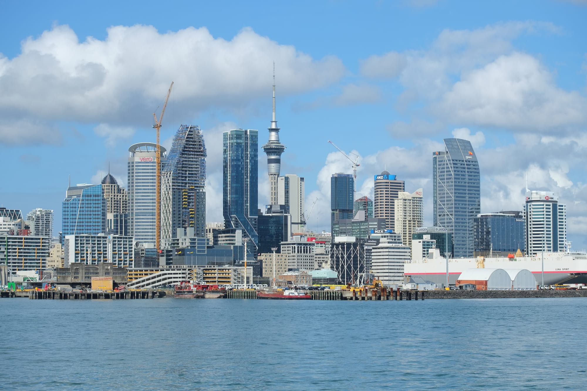
Auckland's high-rise city centre and the needle of the Sky Tower seen across the blue water of the harbour, with wharves in front

Auckland & Northland, New Zealand

Auckland

The Auckland city centre and Sky Tower seen from the entrance to Waitematā Harbour. (Pseudopanax at English Wikipedia / Wikimedia Commons · Public domain)

New Zealand's largest city, built on a narrow isthmus between the Waitematā and Manukau harbours and on a field of around fifty small volcanoes. Founded in 1840 and the colonial capital until 1865, it grew into the country's commercial centre and one of the most diverse cities in the Pacific, with large Māori, Samoan, Tongan, Chinese and Indian communities.

Neighbourhoods

  • City Centre
    • First-time visitors
    • Close to public transport
    • Nightlife

    The compact downtown that runs uphill from the ferry terminal, with Queen Street as its spine, the Sky Tower above it and most of the city's hotels within a few blocks. The Britomart quarter, the Viaduct Harbour and Wynyard Quarter line the waterfront, and ferries, trains and buses all converge here.

    Open in Maps
  • Ponsonby and Grey Lynn
    • Best for food
    • Bars
    • Villa architecture

    A ridge of restored timber villas immediately west of the centre. Ponsonby Road is one of the city's main eating and drinking streets, with Grey Lynn and Kingsland close by; the area was a working-class and strongly Pacific neighbourhood before it gentrified from the 1980s.

    Open in Maps
  • Karangahape Road
    • Nightlife
    • Live music
    • Independent shops

    Known simply as K Road, a ridge-top street at the top of the city centre with bars, clubs, record and vintage shops, galleries and a long history as the heart of Auckland's queer nightlife.

    Open in Maps
  • Parnell and Newmarket
    • Historic district
    • Shopping
    • Museums

    Auckland's oldest suburb sits on the far side of the Auckland Domain, with the timber shopfronts of Parnell Rise, Holy Trinity Cathedral and the rose gardens. Newmarket next door is the city's main shopping district outside the centre, and both are within walking distance of the Auckland Museum.

    Open in Maps
  • Devonport and the North Shore
    • Quiet and residential
    • Views
    • Day trips by ferry

    A Victorian naval village across the harbour, reached by a short ferry from downtown, with cafés on Victoria Road, swimming beaches and two volcanic hills looking back at the skyline. The wider North Shore beyond it is suburban and beach-lined.

    Open in Maps
  • Mount Eden and Epsom
    • Quiet and residential
    • Walks and viewpoints
    • Family-friendly

    Inner suburbs of bungalows and villas around two of the city's volcanic cones, both climbed for the view across the isthmus. Mount Eden Village and Dominion Road's Asian restaurants are the local centres.

    Open in Maps
  • Tāmaki Drive and the eastern bays
    • Beaches
    • Cycling
    • Family-friendly

    The waterfront road east of the centre passes a string of sheltered beaches — Ōkahu, Mission Bay, Kohimarama and St Heliers — backed by cafés, with Rangitoto in view across the water and a cycle path the whole way.

    Open in Maps
  • South Auckland
    • Local life
    • Best for food
    • Markets

    The suburbs around Ōtara, Māngere, Papatoetoe and Manukau form the centre of Pacific life in New Zealand, with island churches, weekend markets and Samoan, Tongan and Cook Islands food. The airport is on its western edge.

    Open in Maps

Things to do

Famous landmarks

  • Sky Towerlandmark

    The telecommunications and observation tower that has defined the skyline since 1997, the tallest structure in New Zealand, with viewing decks above the city centre.

    Open in Maps
  • Auckland Harbour Bridgelandmark

    The eight-lane bridge of 1959 that links the city centre to the North Shore; extra lanes made in Japan were added in the late 1960s and are known as the Nippon clip-ons.

    Open in Maps
  • Viaduct Harbourattraction

    A former commercial basin on the downtown waterfront, rebuilt for the America's Cup and now ringed by restaurants, superyachts and apartments.

    Open in Maps
  • Wynyard Quarterneighborhood

    A former tank farm and fishing port next to the Viaduct, redeveloped with public space, a playground, an old lifting bridge and waterside bars.

    Open in Maps
  • Eden Parkattraction

    New Zealand's largest stadium, in the suburb of Kingsland, the main Auckland ground for rugby and cricket.

    Open in Maps

Museums and galleries

  • Auckland War Memorial Museummuseum

    A neoclassical building on the rim of an old volcano in the Auckland Domain, holding major Māori and Pacific collections, including the carved war canoe Te Toki-a-Tapiri, above natural history and war memorial galleries.

    Open in Maps
  • Auckland Art Gallery Toi o Tāmakimuseum

    The country's largest art collection, in an 1887 building extended with a timber-canopied wing in 2011, strong on New Zealand painting and Māori portraiture.

    Open in Maps
  • New Zealand Maritime Museummuseum

    On the Viaduct waterfront, telling the story of Pacific voyaging, immigrant ships and yachting, with heritage vessels that sail from the wharf.

    Open in Maps
  • Museum of Transport and Technologymuseum

    Known as MOTAT, a large museum of aircraft, trams, trains and machinery near Western Springs, linked between its two sites by a working tram line.

    Open in Maps
  • Kelly Tarlton's Sea Life Aquariumattraction

    An aquarium built into former sewage storage tanks on Tāmaki Drive, with walk-through tunnels and an Antarctic section.

    Open in Maps

Volcanoes, parks and viewpoints

  • Maungawhau / Mount Edenviewpoint

    The highest of the isthmus volcanoes, with a deep grassy crater, terraces from the pā that once stood on it and a view over both harbours.

    Open in Maps
  • Maungakiekie / One Tree Hillviewpoint

    A cone in Cornwall Park crowned by an obelisk, the largest pā on the Auckland isthmus, with sheep still grazing the surrounding farm park.

    Open in Maps
  • Auckland Domainpark

    The city's oldest park, laid out in an explosion crater beside the centre, with the museum, sports fields, a duck pond and the glasshouses of the Wintergardens.

    Open in Maps
  • Rangitoto Islandattraction

    The low symmetrical volcano in the Hauraki Gulf, formed about 600 years ago and reached by ferry, with a track through lava fields and pōhutukawa forest to the summit.

    Open in Maps
  • Bastion Pointviewpoint

    A clifftop reserve above the harbour, site of a long Ngāti Whātua Ōrākei land occupation in 1977–78 and of the Michael Joseph Savage memorial.

    Open in Maps
  • Auckland Botanic Gardenspark

    Large council gardens in Manurewa in the south of the city, with native plant collections, a rose garden and a sculpture exhibition held every second summer.

    Open in Maps
  • Auckland Zooattraction

    A zoo beside Western Springs park, with a section of native New Zealand wildlife and a kiwi and tuatara house.

    Open in Maps

Beaches and the coast

  • Mission Baybeach

    The busiest of the sheltered eastern beaches, with a fountain, lawn and a row of cafés facing Rangitoto.

    Open in Maps
  • Pihabeach

    A black-sand surf beach on the west coast beyond the Waitākere Ranges, dominated by Lion Rock, with powerful rips and a surf-lifesaving tradition.

    Open in Maps
  • Muriwaibeach

    A long west-coast beach north of Piha with a gannet colony on the cliffs at its southern end, watched from viewing platforms in spring and summer.

    Open in Maps
  • Waitākere Rangespark

    A forested range of hills west of the city with rainforest tracks, waterfalls and dams; some tracks remain closed and others have been rebuilt with boardwalks to slow the spread of kauri dieback.

    Open in Maps

Markets and streets

  • Karangahape Roadneighborhood

    The city's most eclectic street, with live-music venues, bars, galleries and second-hand shops along a ridge above the motorway.

    Open in Maps
  • Ōtara marketmarket

    A Saturday-morning market in South Auckland's car park beside the town centre, the best-known Pacific market in the country for taro, coconuts, island produce and cooked food.

    Open in Maps

Short trips from the city

  • Waiheke Islandattraction

    A hilly island about 40 minutes by ferry, with vineyards, olive groves, beaches and art studios.

    Open in Maps
  • Tiritiri Matangi Islandattraction

    An open sanctuary island in the Gulf, replanted by volunteers, where takahē, saddlebacks and other rare birds can be seen along its tracks.

    Open in Maps
  • Motutapu Islandattraction

    The older, grassy island joined to Rangitoto by a causeway, with farmland, wartime defences and walking tracks.

    Open in Maps
  • Puhoiattraction

    A small village north of the city settled by Bohemian immigrants in 1863, with a historic hotel, a church and a river for kayaking.

    Open in Maps

Seasonal events

  • Auckland Anniversary weekendlate January

    A public holiday weekend marking the province's founding, traditionally centred on a regatta on the Waitematā Harbour.

  • Auckland Lantern FestivalFebruary or March

    Lunar New Year lanterns, food stalls and performances, held in the city over several evenings.

  • Pasifika FestivalMarch

    One of the largest Pacific cultural festivals in the world, with village areas for Samoa, Tonga, Niue, the Cook Islands and other nations.

  • Auckland Arts FestivalMarch

    A city-wide festival of theatre, dance, music and Māori and Pacific performance.

Eat and drink

Long-standing places and food districts in Auckland. Hours, ratings and directions come from your maps app, always current.

Auckland classics

  • Depot Eateryrestaurant

    A dining room on Federal Street beside the SkyCity complex, opened in 2011 by the chef Al Brown, known for shucked oysters and simple plates of New Zealand produce.

    Open in Maps

Food districts and markets

  • Dominion Roadneighborhood

    A long inner-suburban road lined with Chinese, Taiwanese, Malaysian and Vietnamese restaurants, dumpling houses and bubble tea shops.

    Open in Maps
  • Sandringhamneighborhood

    The centre of the city's South Asian food, with sweet shops, dosa and biryani restaurants and grocers along Sandringham Road.

    Open in Maps
  • Ponsonby Roadneighborhood

    Restaurants, wine bars and a food hall in a converted picture theatre along the city's best-known eating street.

    Open in Maps
  • Ōtara Marketmarket

    Saturday-morning stalls of taro, green bananas, coconuts, fresh fish and Pacific cooked food in South Auckland.

    Open in Maps

Cafés and bars

  • Britomart and Commercial Bayneighborhood

    Restored warehouses and a modern retail centre near the ferry terminal, holding a dense cluster of cafés, bars and restaurants.

    Open in Maps
  • Grey Lynn and Kingsland cafésneighborhood

    The inner-west villa suburbs where Auckland's flat-white culture is at its strongest, with roasteries and brunch places on Richmond Road and New North Road.

    Open in Maps

Experience Auckland

History

The Auckland isthmus, Tāmaki Makaurau, was one of the most densely settled parts of the country before European arrival. Its volcanic cones were terraced into fortified pā, with kūmara gardens on the fertile ash soils and portages between the two harbours that let canoes cross from the Pacific to the Tasman in a day. Musket warfare in the 1820s emptied much of the isthmus, and by 1840 the area was only lightly occupied when Ngāti Whātua leaders offered land to the Lieutenant-Governor, William Hobson, who founded a town there in September of that year and named it after the Earl of Auckland.

Auckland was the colonial capital until 1865, when Parliament moved to Wellington as a more central site. The loss of government did not slow it: the harbour, the gum and timber trades, the Waikato farmland opening to the south and later refrigerated shipping made it the country's busiest port and largest city. Suburbs spread along tram and rail lines, and the hills of Ponsonby and Grey Lynn filled with wooden villas.

The twentieth century reshaped it twice. After the Second World War, Māori moved to the city from the countryside in great numbers, and migrants arrived from Samoa, Tonga, the Cook Islands and Niue — a movement soured by the dawn raids on Pacific families in the 1970s, for which the government apologised in 2021. The Harbour Bridge of 1959 and the motorways opened the North Shore and the far suburbs to low-density growth. Immigration policy changes from the late 1980s brought new arrivals from Asia, and in 2010 the city and its surrounding districts were merged into a single Auckland Council.

Culture & Customs

Auckland is the largest Polynesian city in the world and the most diverse place in New Zealand: roughly four in ten residents were born overseas, and Samoan, Tongan, Cook Islands Māori, Mandarin, Cantonese, Hindi and te reo Māori are all widely spoken. That mix shows in the churches of South Auckland, the temples and mosques of the suburbs, the Pasifika and Lantern festivals, and in a food scene that owes more to Asia and the Pacific than to Britain.

Māori culture is publicly present. Kapa haka is taught in schools and contested fiercely, iwi names and dual place names appear on signs and official documents, and Matariki, the midwinter rising of the Pleiades, has been a public holiday since 2022. The city's maunga, its volcanic cones, are administered by a collective of iwi with the council.

Boats are the shared passion. Auckland calls itself the City of Sails, and harbour races, dinghy classes and fishing trips fill the weekends; the city hosted the America's Cup in 2000, 2003 and 2021. Rugby dominates winter, with the Blues and Auckland provincial sides at Eden Park, alongside the Warriors in rugby league at Mount Smart Stadium, netball, and cricket in summer. The arts run from the Auckland Art Gallery and the Aotea Centre to a long tradition of independent theatre and hip hop, and the music of Pacific Auckland — from Herbs to Che Fu and beyond — is part of the national songbook.

Daily Life

About 1.8 million people live in the Auckland region, roughly a third of New Zealand's population, in a low-density sprawl that stretches from Wellsford in the north to the Bombay Hills in the south. The economy is the country's largest, built on finance, professional services, the port, construction, education, the airport and tourism; head offices cluster in the city centre and Newmarket, and industry in the south and west.

Where people live divides the city sharply. The eastern bays, the inner harbourside suburbs and parts of the North Shore are wealthy; the south and far west are poorer and younger, with large Māori and Pacific populations. Housing is the central issue of daily life: Auckland has some of the least affordable house prices in the developed world relative to incomes, and the response has been apartment blocks in the centre and townhouses replacing single houses in the suburbs. Commutes are long, and a car is a necessity in much of the city despite steady investment in rail, busways and cycleways.

The rhythm is outdoor and suburban. Mornings begin with coffee — flat whites taken seriously — and summer weekends go to beaches, the Gulf islands, boats, junior sport on Saturday mornings and church on Sunday for many Pacific families. Long holidays empty the city towards the Coromandel and Northland coasts in January.

Food

Auckland eats across the Pacific and Asia. Samoan, Tongan and Cook Islands kitchens supply taro, green bananas and cooked-to-order plates at the South Auckland markets, along with ika mata and oka, raw fish dressed in coconut cream and lime, sapasui, the Samoan version of chop suey, and pork and chicken from a hāngī or an umu earth oven. Chinese, Korean, Vietnamese, Malaysian and Japanese restaurants line Dominion Road, Upper Queen Street, Northcote and Botany, and Sandringham Road is the place for dosa, biryani and Indian sweets. Night markets in suburban car parks sell everything from takoyaki to hurricane potatoes.

Seafood is the local pride: Bluff oysters, green-lipped mussels, snapper, kingfish and crayfish, and fish and chips eaten on the sand — hoki, gurnard or snapper in batter, with a scoop of chips. Whitebait fritters appear in spring, and kina, the roe of sea urchins, is a delicacy for those raised on it.

Coffee is close to a civic institution, roasted locally and served as a flat white, long black or trim latte in cafés that take brunch seriously: eggs, corn fritters and sourdough are standard. Sweet things run to hokey pokey ice cream with its toffee pieces, lamingtons, Afghan biscuits and pavlova topped with kiwifruit or berries. Wine comes from Kumeū and Matakana to the north and Waiheke across the water, and the craft beer scene is concentrated in taprooms around the city fringe.

Planning tools

Budget

Auckland is New Zealand's most expensive city for accommodation, and prices rise sharply from Christmas to late January and around big concerts and rugby tests. Food and drink cost about as much as in a mid-sized Australian city. The biggest savings come from staying near a ferry, train or busway route rather than hiring a car, since city parking is costly.

Daily Budget Midrange
USD 150–300 (hotel or motel room, restaurant meals, museum entry, a harbour cruise or island ferry)
Daily Budget Shoestring
USD 60–100 (hostel bed or campsite, supermarket and food-court meals, buses, trains and ferries on an AT HOP card)

Many of the best things cost nothing — the volcanic cones, the Domain, the eastern-bay beaches, the Auckland Art Gallery's permanent collection and the waterfront walk from Britomart to Wynyard Quarter.

Best Time to Visit

November to April, with February and March the warmest and most settled months and quieter than the school holidays that run from Christmas to late January. Spring and autumn are mild and green but wetter. Winter brings rain and grey days rather than cold, and hotel rates fall.

Suggested Number of Days

Two or three days cover the centre, the museums and one volcanic cone. Five or six allow the Gulf islands and the west coast as well. The city is spread out, so travel between districts takes longer than the map suggests, and bad weather can cancel boat trips.

First Visit
2–3 days
With Surroundings
5–6 days

Transportation

Auckland Transport runs buses, four suburban rail lines and a network of ferries across the harbour and to the Gulf islands, all paid for with an AT HOP card or a contactless bank card. Frequent bus routes and the busways to the north and south-east are the quickest way around the inner city; the rail network radiates from the downtown Waitematā station at Britomart. Traffic on the motorways is heavy at peak times, and a car is more useful for the west coast and the far north than for the city itself.

Ferries from the downtown terminal are the most pleasant way to travel: Devonport takes about twelve minutes and Waiheke around forty.

Airport & Station Connections

Auckland Airport, at Māngere about 21 kilometres south of the centre, is the country's main international gateway and handles domestic flights to every large town. The drive downtown takes about 40 minutes and longer in peak traffic; express buses run the same route. Long-distance coaches and the Northern Explorer train to Wellington leave from the city, and cruise ships berth at Queens Wharf in the middle of the waterfront.

Walkability

The city centre is walkable but steep: Queen Street runs along a valley floor, and the streets either side climb hard to Karangahape Road and Albert Park. The waterfront from Britomart to Wynyard Quarter is flat and easy, and Parnell, Ponsonby and Devonport are pleasant on foot. Beyond that the suburbs are low-density and separated by motorways, so most journeys need a bus, train or ferry.

Safety

Auckland is generally safe, with the risks of any large city: bag snatching and street begging in parts of the city centre, break-ins at beach and trailhead car parks, and occasional late-night trouble around bars. Retail crime and car theft have been a public concern in recent years. The greater dangers are natural — west coast beaches such as Piha and Muriwai have strong rips and claim lives most years, and heavy rain can cause flash flooding, as it did across the city in January 2023.

Swim between the flags at patrolled beaches, leave nothing visible in a parked car, and clean footwear at kauri dieback stations on forest tracks. Check current official travel advice before travelling.

Climate

A mild, humid maritime climate with rain spread through the year and frost almost unknown near the coast. Weather changes quickly, and a day can hold sun, wind and heavy showers. Summer runs from December to February, winter from June to August. Ex-tropical cyclones occasionally reach the city between January and April.

Summer
warm and humid, with daytime temperatures usually 22–26°C and sea warm enough for swimming
Winter
mild and wet, 14–16°C by day, with long rainy spells and strong westerlies

Local Customs

Manners are informal and understated; first names are normal and loud self-promotion goes down badly. Tipping is not expected, and service charges are unusual outside a few restaurants. Māori greetings are part of public life — kia ora for hello, and a hongi, the pressing of noses, at formal welcomes. Shoes are usually removed at the door of a house, and always before entering a wharenui, the carved meeting house on a marae.

Ask before photographing people or ceremonies, treat volcanic cones and other maunga as the significant sites they are by staying on tracks, and do not eat or drink inside a marae meeting house. The drinking age is 18 and identification is often requested.

Common Payment Methods

The currency is the New Zealand dollar. Cards and contactless payment are accepted almost everywhere, including on buses, trains and ferries, and many places no longer handle cash at all. A surcharge on card payments is legal and sometimes applied. ATMs are common, and foreign cards work at bank machines; some market stalls still prefer cash.