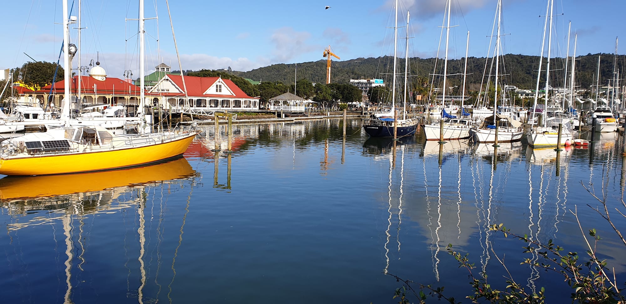
Yachts moored in a still basin reflecting their masts, with red-roofed waterfront buildings and a wooded hill behind

Auckland & Northland, New Zealand

Whangārei

The Town Basin marina at the head of Whangārei Harbour. (Keisenhut / Wikimedia Commons · CC BY-SA 4.0)

Northland's only city, at the head of a long tidal harbour on the east coast of the North Island. It grew on coal, kauri timber and gum, then on the oil refinery and port at Marsden Point, and now centres on a yacht basin ringed by cafés, galleries and the Hundertwasser Art Centre, with waterfalls, limestone caves and surf beaches close by.

Neighbourhoods

  • Town Basin
    • First-time visitors
    • Best for food
    • Galleries

    The head of the harbour, where the Hātea River widens into a marina. A loop of boardwalk passes the Hundertwasser Art Centre, craft shops, galleries, a clock museum and a row of cafés and restaurants, and a curved pedestrian bridge crosses to the far bank.

    Open in Maps
  • City centre
    • Shopping
    • Close to public transport
    • Local life

    A short walk uphill from the basin, the compact commercial grid around Cameron Street and Bank Street holds the main shops, the pedestrian mall and the bus interchange.

    Open in Maps
  • Kensington and Tikipunga
    • Quiet and residential
    • Family-friendly
    • Close to the falls

    Northern suburbs of bungalows on the slopes above the city, with the sports park at Kensington and, further out at Tikipunga, Whangārei Falls and the kauri parks along the Hātea River.

    Open in Maps
  • Onerahi and the harbour road
    • Quiet and residential
    • Views
    • Close to the airport

    Suburbs strung along the northern shore of the harbour east of the centre, with the small airport, mangrove-edged inlets, boat ramps and a coastal walkway back towards the Town Basin.

    Open in Maps
  • Whangārei Heads
    • Beaches
    • Walks and viewpoints
    • Quiet and residential

    A chain of small settlements about 35 kilometres out along the harbour's southern arm, beneath the volcanic crags of Mount Manaia, ending at Ocean Beach and the Bream Head reserve — the district's best walking and swimming country.

    Open in Maps
  • Tutukākā coast
    • Beaches
    • Diving
    • Holiday homes

    North-east of the city, a coast of small bays, a marina at Tutukākā that is the departure point for diving at the Poor Knights Islands, and the holiday settlements of Matapōuri, Sandy Bay and Ngunguru.

    Open in Maps

Things to do

In the city

  • Hundertwasser Art Centremuseum

    A gallery opened in February 2022 on the Town Basin, the last authentic building designed by the Austrian artist Friedensreich Hundertwasser, with a roof planted in rare native species, eighty of his works upstairs and the Wairau Māori Art Gallery of contemporary Māori art below.

    Open in Maps
  • Claphams National Clock Museummuseum

    A museum of clocks and timepieces at the Town Basin, grown from about four hundred clocks donated by Archibald Clapham, who also bought Whangārei Falls to save them from development.

    Open in Maps
  • Kiwi Northmuseum

    A precinct at Maunu west of the city combining the Whangarei Museum, founded in 1890, relocated historic buildings, an observatory and a kiwi and tuatara house.

    Open in Maps

Waterfalls, parks and caves

  • Whangārei Fallsattraction

    A curtain of water about 26 metres high on the Hātea River in the suburb of Tikipunga, with viewing platforms above and below it.

    Open in Maps
  • A. H. Reed Memorial Parkpark

    A pocket of surviving kauri forest on the Hātea River upstream of the city, joined to Whangārei Falls by a loop walk of about an hour through native bush.

    Open in Maps
  • Mount Parihakaviewpoint

    A bush-covered volcanic dome of 259 metres north-east of the city centre, with walking tracks through its scenic reserve, a road to the summit and a view over the harbour.

    Open in Maps

The coast and the Heads

  • Mount Manaiaviewpoint

    A rock-crowned peak above the harbour entrance, climbed by a stepped track of about an hour and a half to a view over the Heads and Bream Bay.

    Open in Maps
  • Bream Headtrail

    A scenic reserve of coastal forest and volcanic cliffs at the harbour mouth, crossed by the Te Whara Track, a route at least 700 years old.

    Open in Maps
  • Ocean Beachbeach

    A long sandy surf beach on the open coast immediately north of Bream Head, with dunes and a view of the Hen and Chicken Islands twelve kilometres offshore.

    Open in Maps
  • Whangārei Harbourattraction

    A drowned valley of mudflats, mangroves and channels running inland from the Heads to the city, used by wading birds and by boats sheltering on the coastal run north.

    Open in Maps

Short trips from the city

  • Poor Knights Islandsattraction

    A marine reserve of steep uninhabited islands about 22 kilometres offshore, halfway between Bream Head and Cape Brett, with arches, caves and subtropical fish, counted among the world's notable dive sites.

    Open in Maps
  • Matapōuribeach

    A bach settlement and sheltered swimming bay on the Tutukākā coast about 35 kilometres north-east of the city, where holiday homes are nine houses in ten.

    Open in Maps
  • Waipū Cavesattraction

    A limestone cave system near Waipū, about 45 kilometres south, holding a large population of glow worms and entered on foot through a stream.

    Open in Maps
  • Marsden Pointattraction

    The deep-water port and former oil refinery at the harbour mouth, beside the beach town of Ruakākā and the Bream Bay coast.

    Open in Maps

Seasonal events

  • Waipu Highland Games1 January, every year

    A Scottish games meeting held on New Year's Day at Waipu, south of the city, in a district settled by Highland families who came by way of Nova Scotia.

  • MatarikiJune or July

    The Māori new year, marked in and around the city with dawn ceremonies, kapa haka, markets and light displays since it became a public holiday in 2022.

  • Summer at the Town BasinDecember to February

    The city's busiest season, when cruising yachts fill the marina, outdoor concerts and markets run on the basin lawns and the coastal settlements fill with holidaymakers.

Eat and drink

Long-standing places and food districts in Whangārei. Hours, ratings and directions come from your maps app, always current.

Whangārei classics

  • Town Basin restaurantsrestaurant

    The marina boardwalk carries the city's best-known cluster of cafés, seafood restaurants, a brewery bar and ice cream places, all looking over the moored yachts.

    Open in Maps
  • Fish and chips at the Headsrestaurant

    Snapper, gurnard and scallops in batter from takeaway shops in the suburbs and the harbour settlements, eaten at the beach or a boat ramp.

    Open in Maps

Markets and produce

  • Whangārei city centre caféscafe

    Cameron Street and the surrounding blocks hold roasteries, bakeries and brunch cafés used by the working city rather than by visitors.

    Open in Maps
  • Ruakākā and Bream Bay foodneighborhood

    Beach-town takeaways, a bakery and casual eating places south of the harbour, close to the surf beach and the port.

    Open in Maps

Experience Whangārei

History

The harbour drew people early. Māori settled its shores and the volcanic ridges at its mouth and gardened the warm northern slopes; the harbour's Māori name, Whangārei-te-rerenga-parāoa, is understood as the place where whales gather. Ngāpuhi and Ngāti Wai hapū held the district, and the sheltered inlets were valuable for fishing, shellfish and canoe travel down the coast.

European trade began with spars and flax in the 1830s, and a small settlement formed at the head of the harbour in the 1840s. Its early history was interrupted by the Northern War and by repeated departures, but coal changed the district's prospects: it was mined at Whau Valley, Kamo and Hikurangi, and coal from the Kiripaka field went out by way of the Ngunguru River. Kauri timber and kauri gum, dug out of the northern gumfields, passed through the town, along with limestone, cement and later dairy produce from the farms cleared out of the bush.

Whangārei was declared a city in 1964, by then the service centre for all of Northland. The refinery built at Marsden Point in the 1960s and the deep-water port beside it made the harbour industrial at its mouth and gave the district its largest employer for half a century; the refinery stopped processing crude oil in 2022 and became an import terminal. The Town Basin, once working wharves and boatyards, was rebuilt from the 1980s as a marina and cultural quarter, a change completed by the opening of the Hundertwasser Art Centre in 2022 after decades of local argument about whether to build it.

Culture & Customs

The city's public culture is shaped by the harbour and by Māori Northland. Ngāpuhi and Ngāti Wai marae around the district run their own events, kapa haka is strong in local schools, and te reo Māori appears on signs, in broadcasting and in everyday greetings more than in most New Zealand cities. Matariki, the midwinter rising of the Pleiades, is marked with dawn ceremonies and festivals.

Art has become the city's calling card. Hundertwasser's connection to Northland — he lived near Kawakawa from the 1970s until his death in 2000 — produced first the famous public toilets in that town and then the art centre at the Town Basin, whose Wairau Māori Art Gallery shows contemporary Māori work. Sculpture stands along the basin boardwalk, and craft galleries, potters and carvers work throughout the district.

Otherwise the culture is outdoor and practical. Rugby and league are followed closely, surf lifesaving clubs patrol the ocean beaches, and diving, fishing, sailing and surfing take up weekends; the Poor Knights Islands have given the city a long association with diving. Cruising yachts from around the world spend the southern summer in the basin, giving the waterfront a mix of accents, and the Scottish descent of the Waipu settlers to the south is still celebrated with pipe bands and Highland games on New Year's Day.

Daily Life

About 55,000 people live in the city and roughly 100,000 in the wider district, making it the largest urban area north of Auckland. Suburbs spread up the hills at Kensington, Tikipunga, Kamo, Maunu and Onerahi, with newer subdivisions pushing outward and small settlements strung along both arms of the harbour and the coast beyond.

The economy rests on services for the whole of Northland — the hospital, schools, the council and retail — alongside the port at Marsden Point, marine trades and boatbuilding, engineering, forestry, dairying and horticulture in the surrounding countryside, and a steady flow of tourism. Northland incomes are among the lowest in the country, unemployment tends to run above the national rate, and social problems including housing shortages and poor-quality rentals are persistent local issues. At the same time the district attracts retirees and remote workers from Auckland, pushing up house prices.

Life runs at a small-city pace: early starts, a working day that empties the centre by evening, sport and fishing at weekends, and long drives treated as routine. School holidays and Christmas transform the coast, filling Ruakākā, Ocean Beach, Matapōuri and Ngunguru with families in baches and campgrounds. Storm damage, road resilience on State Highway 1 and the health of the harbour are the recurring public concerns.

Food

Seafood is the foundation. Snapper is the prized catch of the east coast, with kahawai, gurnard, trevally and kingfish alongside it, and scallops, mussels, crayfish and Pacific oysters come from the harbours and bays. Takeaway fish and chips eaten at a beach or boat ramp is the standard local meal, and smoked fish is sold from small roadside shops.

The countryside supplies the rest. Northland's warmth suits subtropical growing: kūmara from the Kaipara flats to the west, citrus and avocados from around Kerikeri and Maungatapere, macadamias, olives, kiwifruit, feijoas and persimmons, and mānuka honey from the hills. Dairying produces milk, cream and cheese, and beef and lamb come off the surrounding farms. Growers sell much of it directly, from roadside stalls and market vans, before it reaches the shops.

Māori food traditions remain everyday rather than ceremonial here. Hāngī — meat, kūmara, pumpkin and stuffing steamed in a covered earth oven — is cooked for family and community gatherings and sold as takeaway packs by fundraising groups, often with rēwena bread raised on a fermented potato starter. Shellfish gathered from the rocks and flats, including pipi, tuatua and kina, is part of local eating, with size and season rules.

In the city itself the cooking is unfussy: café brunches, bakeries selling pies and custard squares, Chinese, Indian and Thai restaurants, a brewery at the basin, and restaurants that put local fish, lamb and vegetables on a short menu.

Planning tools

Budget

Whangārei is among the cheaper places to stay in the upper North Island, with motels, holiday parks and campsites at well below Auckland or Bay of Islands rates. Prices rise on the coast at Tutukākā and Whangārei Heads over Christmas and January. Diving trips to the Poor Knights are the single biggest cost most visitors face.

Daily Budget Midrange
USD 150–300 (motel or B&B, restaurant meals, a hire car, a dive or boat trip)
Daily Budget Shoestring
USD 50–85 (hostel bed or holiday park site, supermarket food, free waterfalls, parks and beaches)

The city's best-known sights — the falls, the kauri boardwalk, the Town Basin loop and the Heads walks — are free, so the budget goes mainly on a vehicle and one trip on the water.

Best Time to Visit

November to April, when the sea is warm enough for swimming and diving and the coast is at its best; February and March are settled and quieter than the Christmas school holidays. Winter is mild and green, good for walking and the museums, but wet, and visibility for diving is less reliable.

Suggested Number of Days

One or two days cover the city itself. Three or four allow the coast on either side and a trip offshore. Most visitors treat it as a stop on the way further north, and a longer stay makes sense mainly for divers, walkers and surfers.

First Visit
1–2 days
With Surroundings
3–4 days

Transportation

A car is the practical way to get around: the city is spread out, the coast and the Heads are half an hour or more away, and there are no passenger trains in Northland. Local buses serve the suburbs from the city centre on weekday timetables, and long-distance coaches stop here on the Auckland to Bay of Islands route. Cycling is growing, with a shared path along the Hātea River.

Roads to the Heads and the Tutukākā coast are narrow and winding, and journeys take longer than the distances suggest.

Airport & Station Connections

Whangārei is about 160 kilometres north of Auckland, roughly two to two and a half hours by car on State Highway 1, and a little longer by coach. Its airport at Onerahi, about eight kilometres from the centre, has frequent short flights to Auckland. Many cruising yachts arrive by sea and clear customs at Marsden Point before coming up the harbour to the Town Basin.

Walkability

The Town Basin, the pedestrian bridge and the city centre make an easy flat loop on foot, and a riverside path continues from the basin towards the falls. Beyond that the city is low-density and hilly, and the suburbs, beaches and reserves need a vehicle. The coastal walkway from Onerahi and the tracks up Parihaka and Manaia are the local walks.

Safety

A generally safe city with the usual risks of car break-ins at trailheads and beach car parks, and some late-night trouble around bars at weekends. The greater hazards are natural: strong rips on the open-coast surf beaches, unlit and slippery caves at the Waipū Caves, where a stream can rise fast in rain, and slips and flooding that close Northland roads after heavy storms.

Swim between the flags where beaches are patrolled, take a torch and a companion into the caves and stay out of them in wet weather, and check road conditions after storms. Check current official travel advice before travelling.

Climate

Warm, humid and subtropical in character, with rain spread through the year and frost rare near the coast. Summer runs from December to February and winter from June to August. Ex-tropical cyclones can bring heavy rain and wind between January and April, and Cyclone Gabrielle caused serious damage across Northland in February 2023.

Summer
warm and humid, usually 23–26°C by day, with sudden heavy showers
Winter
mild and wet, 15–17°C by day, with strong winds between fronts

Local Customs

Manners are rural and informal, and a nod or a raised finger from the steering wheel is a normal greeting on country roads. Northland has one of the highest Māori populations of any region, te reo Māori is widely used in place names and greetings, and marae are central to community life. Tipping is not expected, and service is friendly but unhurried.

Shoes come off before entering a wharenui, and food and drink stay outside it; permission should be asked before photographing people, marae or ceremonies. Kauri forest tracks have cleaning stations that must be used to slow the spread of kauri dieback.

Common Payment Methods

The currency is the New Zealand dollar. Cards and contactless payment are accepted almost everywhere, including on local buses, though a card surcharge is sometimes added. ATMs are easy to find in the city and much scarcer in the coastal settlements, where some small shops, campgrounds and market stalls prefer cash.