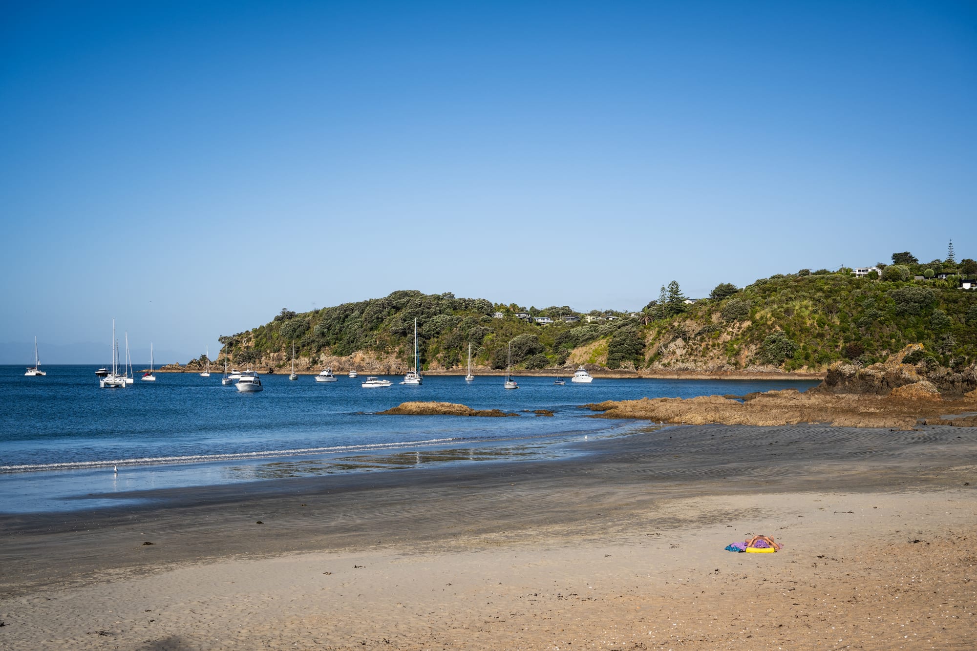
Wide sandy beach with yachts moored in a blue bay and a wooded headland with houses beyond

Auckland & Northland, New Zealand

Waiheke Island

Yachts anchored off Oneroa Bay on the north coast of Waiheke Island. (Takeshi Aida / Wikimedia Commons · CC BY-SA 2.0)

A hilly island in the Hauraki Gulf about 20 kilometres east of central Auckland, reached by frequent passenger ferries. Once a farming and holiday island of baches and orchards, it is now known for vineyards on its north-facing slopes, olive groves, sheltered sandy bays, art studios and a permanent population that commutes to the city by boat.

Neighbourhoods

  • Oneroa
    • First-time visitors
    • Best for food
    • Beaches

    The island's main village, on a ridge above a long white beach at the western end. Ocean View Road holds the shops, galleries, cafés and restaurants, the library and the bus stop, and Little Oneroa with its playground is a short walk east.

    Open in Maps
  • Matiatia and Church Bay
    • Close to public transport
    • Walks and viewpoints
    • Quiet and residential

    Matiatia is the ferry harbour where almost every visitor arrives, at the foot of a valley with buses, bike hire and a coastal track over the headlands. Church Bay next to it is a quiet stretch of clifftop houses and vineyards looking back towards the city.

    Open in Maps
  • Palm Beach and Ostend
    • Beaches
    • Markets
    • Local life

    The island's working middle. Ostend has the island's only supermarket, a medical centre and a council office, and is where most residents shop; Palm Beach, over the hill on the north coast, is a curved swimming bay backed by pōhutukawa trees.

    Open in Maps
  • Onetangi
    • Beaches
    • Family-friendly
    • Wineries nearby

    A wide, straight sweep of sand about 1.8 kilometres long on the north coast with a small cluster of accommodation, a beachfront bar and several vineyards on the ridges behind it.

    Open in Maps
  • Rocky Bay and Whakanewha
    • Quiet and residential
    • Walks and viewpoints
    • Birdwatching

    The south-facing side of the island, where Ōmiha, known as Rocky Bay, looks over tidal flats towards the regional park at Whakanewha — sheltered water, native forest and far fewer people than the north coast.

    Open in Maps
  • The eastern end
    • Wineries
    • Remote beaches
    • Scenic drives

    Beyond Onetangi the sealed road gives way to gravel through large vineyard and farm estates towards Man O' War Bay and the gun emplacements at Stony Batter. The bays here are the emptiest on the island.

    Open in Maps

Things to do

Beaches and bays

  • Oneroa Beachbeach

    A long, sheltered white-sand beach below the main village, safe for swimming and lined with pōhutukawa that flower red at Christmas.

    Open in Maps
  • Onetangi Beachbeach

    A north-facing beach with about 1.87 kilometres of white sand, backed by holiday houses, with surf on windy days.

    Open in Maps
  • Palm Beachbeach

    A white-sand bay on the north coast, named for the mature phoenix palms at its eastern end, sheltered and safe for swimming.

    Open in Maps

Walks, parks and history

  • Whakanewha Regional Parkpark

    A council park of regenerating coastal forest and a quiet south-coast beach, with walking tracks and a large wetland where bittern, banded rail and fernbird live.

    Open in Maps
  • Stony Batterlandmark

    A Second World War coastal defence complex at the island's eastern end, with gun pits and a long tunnel system under farmland strewn with volcanic boulders.

    Open in Maps
  • Matiatia to Oneroa coastal walktrail

    A headland path from the ferry wharf to the village, passing Owhanake Bay and clifftop viewpoints over the gulf.

    Open in Maps

Wine, art and markets

  • Waiheke vineyardsattraction

    Small wineries work the island's sheltered slopes, planted mainly in syrah and cabernet sauvignon, most of them open for tastings and many with restaurants looking over the gulf.

    Open in Maps
  • Waiheke Community Art Gallerymuseum

    The community art gallery, established in 1995, which shows work by the island's unusually large population of resident artists and founded its biennial sculpture exhibition.

    Open in Maps

Short trips from the island

  • Rotoroa Islandattraction

    A small restored island off Waiheke's eastern end, once a Salvation Army treatment home and now a wildlife sanctuary with beaches and a museum, reached by ferry.

    Open in Maps
  • Rangitoto Islandattraction

    The young volcanic cone at the mouth of Waitematā Harbour, climbed through lava fields on a track from the wharf.

    Open in Maps

Seasonal events

  • Sculpture on the Gulfsummer, in alternate years

    An outdoor sculpture exhibition on the headland above Matiatia Bay, held every second year since 2003, with works by New Zealand artists sited above the sea.

  • Waiheke Jazz FestivalEaster, in April

    Concerts in vineyards, halls and bars across the island over the Easter weekend.

  • Waitangi Day and summer holidaysDecember to February

    The island's busiest weeks, when ferries run full and almost every holiday home and bach is occupied.

Eat and drink

Long-standing places and food districts in Waiheke Island. Hours, ratings and directions come from your maps app, always current.

Island classics

  • Vineyard restaurantsrestaurant

    Several of the wineries on the ridges above Oneroa, Church Bay and Onetangi run dining rooms and terraces, serving local lamb, seafood and vegetables with their own wine.

    Open in Maps
  • Oneroa villageneighborhood

    Ocean View Road and the lanes off it hold the island's densest group of cafés, bakeries, a pizza place, Asian kitchens and bars, most of them small and busy in summer.

    Open in Maps
  • Onetangi beachfrontrestaurant

    A beachfront bar and a small number of restaurants face the sand at Onetangi, the usual stop after a swim on the north coast.

    Open in Maps

Markets and produce

  • Island olive oil and honeymarket

    Olive groves on the island press extra virgin oil that is sold at the gate and in the village shops, along with local honey.

    Open in Maps

Experience Waiheke Island

History

The island's Māori name is usually translated as 'island of trickling waters', while an older name, Te Motu-arai-roa, means 'the long sheltering island'. Waiheke was occupied for centuries by hapū associated with Ngāti Pāoa and other Hauraki Gulf iwi, who built pā on its headlands and fished and gardened along its sheltered northern bays; terraces and middens survive on several points. The gulf was a busy waterway of canoe traffic between the Hauraki Plains, the Coromandel and the Auckland isthmus, and the island's position made it both productive and contested during the fighting of the early nineteenth century.

European settlement followed the founding of Auckland in 1840. Timber was cut from the island's forests for the new town, and kauri gum was dug from the ground; farms cleared the hills for sheep and cattle, and a small industry quarried stone. From the late nineteenth century steamers began bringing Aucklanders across for picnics and camping, and subdivisions sold sections to city families, who built simple weekend baches with water tanks and long-drop toilets. For much of the twentieth century Waiheke was a modest holiday island with unsealed roads, a farming population and no mains water supply.

Two changes remade it. Cheap land drew artists, craftspeople and people seeking an alternative life from the 1960s and 1970s, giving the island the bohemian reputation it still trades on. Then growers found that its warm, sheltered slopes suited red wine grapes, and Waiheke became a respected wine district for Bordeaux-style blends and syrah. Fast catamaran ferries from the 1980s turned it into a commuter island and a mass day-trip destination, and its house prices and visitor numbers have risen steeply since.

Culture & Customs

Waiheke has an unusually dense artistic population for its size — painters, potters, sculptors, jewellers, writers and musicians — and open studio weekends, the community gallery in Oneroa and the sculpture exhibition on the Matiatia clifftops are central to how the island sees itself. The counterculture of the 1970s left a lasting streak of environmentalism and independence: community groups run pest-control and replanting projects, there is a long tradition of protest against large developments, and the island votes and organises with a strong sense of being separate from the city that administers it.

Wine now shapes the island's public face. Cellar doors, tasting rooms and vineyard restaurants are the main reason many people visit, and the harvest in late summer sets the rhythm of the working year alongside olive picking in autumn. The tension between that visitor economy and ordinary island life is a constant local subject: full ferries, tour buses on narrow roads, holiday homes left empty in winter and a shortage of housing for the people who work in the cafés and vineyards.

Daily manners are casual and communal. People know their neighbours, drop the formality of the mainland, and gather at the beach, the sports park at Onetangi and the island's small halls and venues. Māori connections to the island remain active through local marae and hapū, and Māori names are used for most of the bays and headlands.

Daily Life

About 9,000 people live on Waiheke year round, and the number on the island can more than double at the height of summer. Oneroa is the commercial centre, Ostend the practical one with the island's only supermarket, and housing spreads through Palm Beach, Surfdale, Blackpool, Ōmiha and the eastern bays. Most homes rely on rainwater tanks and septic systems rather than mains services, which shapes everything from gardens to the length of showers in a dry summer.

The economy rests on tourism, wine, olive oil, building trades, art and small business, and on commuting: a substantial number of residents take the early ferry to work in central Auckland and come home in the evening. Local incomes are mixed, with considerable wealth in clifftop houses alongside families under real pressure from rents, and the shortage of affordable housing for workers is the island's most-discussed problem, along with ferry reliability and fares.

The rhythm of the day is set by boats. Morning sailings carry commuters and schoolchildren, late-morning ones bring visitors, and the last ferry sets the end of a night out in the city. Weekends go to the beach, the market, fishing, sailing and sport, and winter is quiet enough for restaurants to shut for weeks at a time. Conservation work — trapping rats and stoats, replanting bush and guarding nesting birds at Whakanewha — occupies many residents' spare time.

Food

Wine comes first. Waiheke's warm slopes ripen syrah and cabernet sauvignon, its main plantings, for structured reds in the Bordeaux manner, and also produce chardonnay, sauvignon blanc, pinot gris and rosé. The wineries are small by international standards and most sell much of their output at the cellar door, often with a restaurant or terrace attached, so eating and drinking are usually the same outing.

Olive groves are widely planted, and cold-pressed island oil is sold at the gate and in the village shops, along with honey, preserves, sourdough, cheese and vegetables from small growers. Figs, feijoas, citrus and avocados do well in the island's sheltered gardens.

Seafood is local and seasonal: snapper and kingfish from the gulf, kahawai off the rocks, scallops and mussels, and oysters from the northern harbours. Fish and chips eaten on the sand at Oneroa or Onetangi is as much a part of island eating as any vineyard dining room, and smoked fish and crayfish are treats. Restaurant menus lean on New Zealand lamb and beef, fresh fish and vegetables, cooked plainly.

Coffee is taken seriously in the villages, and roasteries, a gelato maker, a small distillery and craft brewing have all found a place. In December the pōhutukawa flower over the beaches, and the food turns to summer holiday standards: barbecues, cold lamb, pavlova and berries.

Planning tools

Budget

Waiheke is one of the more expensive places to stay in the Auckland region, and prices peak from Christmas through January and at weekends. The ferry fare, wine tastings and vineyard meals add up quickly, though the beaches, walking tracks and regional park cost nothing. Many visitors cut costs by coming over for the day from the city.

Daily Budget Midrange
USD 150–300 (guesthouse, motel or apartment, restaurant meals, tastings and a hire car, scooter or e-bike)
Daily Budget Shoestring
USD 60–110 (hostel bed or campground, supermarket food from Ostend, the island bus, beaches and walks)

Accommodation is limited and costs most in summer and on long weekends; day visitors save most by taking the passenger ferry and using the island bus rather than bringing a car.

Best Time to Visit

December to April for swimming, long evenings and the full run of vineyard restaurants; February and March are the warmest and most settled months and quieter than the Christmas holidays. Winter is mild and green, with fewer ferries at night and some businesses closed or on shorter weeks.

Suggested Number of Days

A day trip from the city covers the western end. One or two nights allow the beaches and the quieter south and east as well, and three or four suit walkers doing longer sections of the island's track network. Ferry crossings are occasionally cancelled in strong easterly winds.

First Visit
1–2 days
With Surroundings
3–4 days

Transportation

Passenger ferries arrive at Matiatia, where buses meet the boats and run through Oneroa, Ostend and Onetangi to the eastern settlements on an AT HOP card or contactless card. Car and scooter hire, e-bikes, taxis and hop-on wine tours all operate from the wharf. A vehicle is useful for the east, where roads turn to gravel, but the island is small and roads are narrow and hilly.

Drinking and driving laws are enforced on the island as anywhere else, so people visiting several wineries generally use the bus, a tour or a driver.

Airport & Station Connections

Passenger ferries cross from downtown Auckland to Matiatia in about 40 minutes, running frequently through the day and evening, and some sailings call at Devonport on the North Shore. A vehicle and passenger ferry runs from Half Moon Bay in east Auckland to Kennedy Point and takes around 50 minutes to an hour, with a second car service from Wynyard Quarter. Small planes and helicopters also serve the island.

Walkability

The villages are walkable and the coastal paths are the island's chief pleasure, but the terrain is steep and the settlements are spread over about 20 kilometres, so walking between beaches means real climbs and stretches of road with no footpath. The bus covers the main spine; the walk from Matiatia up to Oneroa takes roughly an hour on the cliff track.

Safety

A safe, low-crime island, with occasional thefts from cars at trailheads and beach car parks. The sea is the main hazard: some north-coast beaches are unpatrolled, currents run around the headlands, and the gravel roads at the eastern end are loose and narrow. Ferry sailings can be disrupted by strong winds, which occasionally leaves day visitors stranded.

Check the last ferry time before heading to the far end of the island, take water on the longer tracks, and swim near other people rather than alone on empty bays. Check current official travel advice before travelling.

Climate

Mild and maritime, with what islanders describe as a micro-climate of its own, warmer and drier than the Auckland isthmus; the maritime climate and old soils suit Bordeaux grape varieties. Summer runs from December to February, winter from June to August, and frost is almost unknown.

Summer
warm and often breezy, usually 22–26°C by day, with warm sea water
Winter
mild and damp, 14–16°C by day, with rain arriving in fronts

Local Customs

Island manners are informal: bare feet in the village shops, first names and a slow pace. Residents are protective of their beaches and quiet lanes, and there is a long-standing tension with the volume of day visitors, so noise late at night and rubbish left on the sand are taken badly. Tipping is not expected anywhere.

Rubbish should be taken away rather than left on the beach, formed tracks respected on private vineyard and farm land, and the narrow lanes at the beaches kept clear when parking. The drinking age is 18 and identification may be requested at tastings.

Common Payment Methods

The currency is the New Zealand dollar. Cards and contactless payment work almost everywhere, including on the ferries, the buses and at cellar doors, and some places take no cash at all. There are ATMs in Oneroa and Ostend, but few elsewhere on the island.