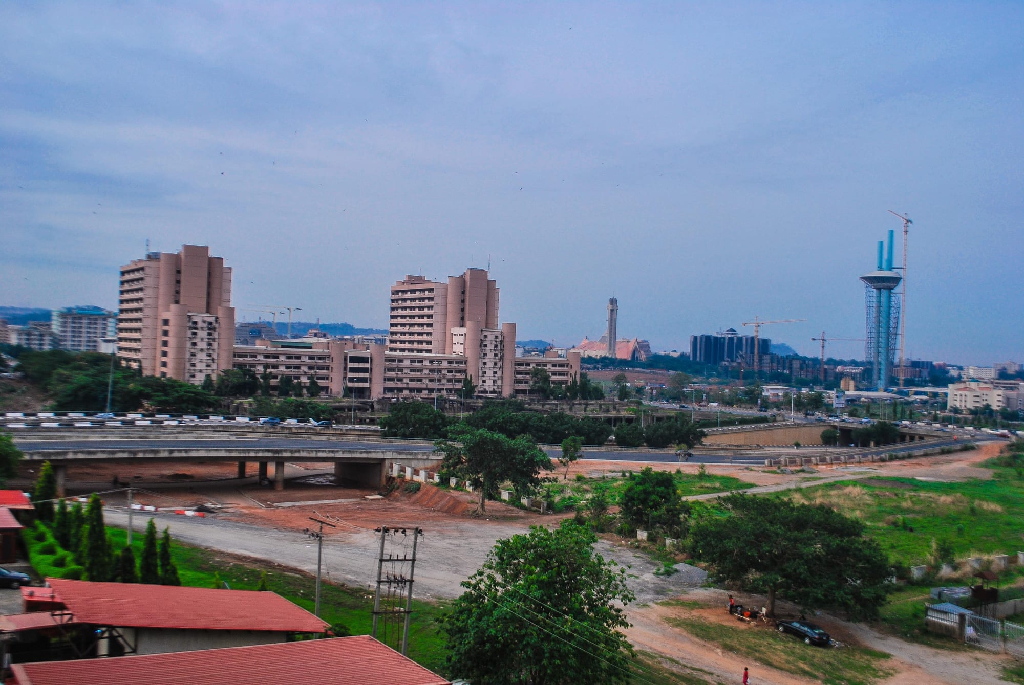
Abuja's central business district seen from above, with pink government blocks, a raised road, green space and wooded hills on the horizon

Abuja & the Middle Belt, Nigeria

Abuja

The central business district of Abuja, with the federal secretariat blocks and the hills beyond. (Kenogenic / Wikimedia Commons · CC BY-SA 3.0)

Nigeria's purpose-built federal capital, laid out in the 1980s on empty savanna in the centre of the country and made the seat of government in 1991 in place of Lagos. Boulevards, ministries and embassies sit below the granite bulk of Aso Rock, while satellite towns beyond the hills house most of the people who work in the city.

Neighbourhoods

  • Central Business District
    • First-time visitors
    • Landmarks
    • Business

    The spine of the plan, running from the National Assembly complex westwards past ministries, banks and the two great religious buildings that face each other across the main axis. It is formal, green and quiet outside office hours.

    Open in Maps
  • Maitama
    • Quiet and residential
    • Hotels
    • Diplomatic quarter

    The wealthiest district, north of the centre against the hills, with embassies, large houses behind walls, gardens and a scattering of restaurants and clubs. Rents here are among the highest in Nigeria.

    Open in Maps
  • Wuse and Wuse II
    • Best for food
    • Shopping
    • Nightlife

    The commercial heart of everyday Abuja, with the city's big market, office blocks, banks and the densest run of restaurants, bars and lounges. Wuse II in particular fills up in the evening.

    Open in Maps
  • Garki
    • Local life
    • Markets
    • Close to transport

    One of the first districts built, south of the centre, with government housing, hospitals, the old international market, motor parks and a more ordinary, workaday feel than Maitama or Asokoro.

    Open in Maps
  • Asokoro
    • Quiet and residential
    • Parks

    A calm residential district east of the centre below Aso Rock, home to the presidential villa, ministers' and governors' lodges and the Millennium Park, with heavy security and little street life.

    Open in Maps
  • Jabi and Utako
    • Waterfront
    • Shopping
    • Nightlife

    North-west of the centre around the Jabi lake, with a shopping mall, a boardwalk beside the water, office blocks and a busy market. It is where Abuja goes out at weekends.

    Open in Maps
  • Gwarinpa and the satellite towns
    • Local life
    • Residential

    Vast housing estates on the northern edge, and beyond them Kubwa, Lugbe, Nyanya and Karu, where most people who work in Abuja actually live. Commuting into the city dominates the working day.

    Open in Maps

Things to do

Landmarks of the capital

  • Abuja National Mosquelandmark

    The gold-domed national mosque on the central axis, built in 1984, with minarets, a library and a conference centre in its complex, open to non-Muslim visitors outside prayer times.

    Open in Maps
  • National Christian Centrelandmark

    The national church facing the mosque across the central district, dedicated in October 2005 and used for state services.

    Open in Maps
  • Aso Rocklandmark

    The granite monolith on the edge of the city, rising about 400 metres above the surrounding land and 936 metres above sea level, which gives its name to the presidential villa at its foot.

    Open in Maps
  • Eagle Squarelandmark

    The ceremonial parade ground built in 1999 in the central business district, used for presidential inaugurations, Independence Day and Armed Forces Remembrance Day parades.

    Open in Maps
  • Nigerian National Assemblylandmark

    The domed legislative complex at the head of the central axis, seat of the Senate and the House of Representatives.

    Open in Maps

Museums and culture

  • Abuja City Gatelandmark

    The concrete gateway on Airport Road at the western entrance to the city, topped by the national flag and coat of arms, erected in 1991 as the formal approach to the capital.

    Open in Maps

Parks and water

  • Millennium Parkpark

    The largest public park in the city, in Maitama, laid out with lawns, water channels and tree-lined walks and inaugurated by Queen Elizabeth II in December 2003.

    Open in Maps
  • Jabi Lakeattraction

    A reservoir formed by an earth dam built to supply the young city with water, now ringed by a boardwalk, boats and a shopping development.

    Open in Maps
  • Bwariattraction

    A hill town north of the city among granite outcrops, home to the Nigerian Law School.

    Open in Maps

Sport and transport

  • Moshood Abiola National Stadiumattraction

    The national stadium south-west of the centre, opened in 2003 for the All Africa Games and used for international football and athletics.

    Open in Maps
  • Nnamdi Azikiwe International Airporttransit hub

    The capital's airport, about 20 kilometres south-west of the centre, with separate international and domestic terminals sharing one runway.

    Open in Maps

Short trips from the city

  • Zuma Rocklandmark

    A huge monolith rising abruptly from the plain at Madalla near Suleja, reaching about 725 metres above sea level, and pictured on the 100-naira note.

    Open in Maps
  • Gurara Fallsattraction

    A waterfall about 30 metres high on the Gurara River, at its fullest late in the rainy season and reduced to channels in the dry months.

    Open in Maps
  • Sulejaattraction

    The town established early in the 19th century by Mohammed Makau, the last Hausa emir of Zaria, and his followers, and known since 1950 for the Ladi Kwali pottery centre.

    Open in Maps

Seasonal events

  • Independence Day1 October

    The national parade and ceremonies at Eagle Square, with the president in attendance and roads across the centre closed.

  • Eid and Christmas celebrationsvaries with the Islamic calendar, and December

    Prayers at the national mosque and services at the Christian centre mark the two great festival seasons, when the city empties as people travel home.

  • Harmattan season eventsDecember to February

    Concerts, weddings and outdoor festivals cluster in the cool, dry months, when the diaspora returns and the evenings are comfortable.

Eat and drink

Long-standing places and food districts in Abuja. Hours, ratings and directions come from your maps app, always current.

Abuja classics

  • Suya grillsneighborhood

    Thin beef skewers rubbed with peppery yaji and grilled over charcoal appear at roadside stands across the city from early evening, a northern speciality that Abuja has made its own.

    Open in Maps
  • Nkwobi and pepper soup loungesneighborhood

    Bars serving spiced cow foot, goat's head and pepper soup with cold drinks, a southern import that fills the lounges of Wuse and Utako.

    Open in Maps

Markets and food districts

  • Wuse Marketmarket

    The city's main market, selling vegetables, grains, fish, spices and cloth, and the best place to see what Middle Belt and northern cooking is built on.

    Open in Maps
  • Garki Marketmarket

    A large market in one of the oldest districts, with food, household goods, tailors and cooked-food stalls.

    Open in Maps
  • Wuse II restaurant streetsneighborhood

    The widest choice of sit-down restaurants in the city, Nigerian and international, spread along the district's avenues.

    Open in Maps
  • Jabi lakeside eatingneighborhood

    Cafés, grills and bars along the boardwalk and around the mall beside the water, busy at weekends.

    Open in Maps

Experience Abuja

History

The land around the site was home to Gbagyi, Koro, Gwandara and other communities long before the capital was planned, with the old town of Abuja — today's Suleja, just outside the territory — founded early in the 19th century by rulers displaced from Zaria during the Fulani jihad. The new city took its name when the older town was renamed to release it.

The decision came in 1976. Lagos, the capital since colonial times, was congested, coastal, vulnerable and identified with one region, and a federal committee recommended a new capital on neutral ground at the geographical centre of the country. A Federal Capital Territory was carved out of parts of Kaduna, Kwara, Niger and Plateau states, its existing inhabitants largely resettled, and an international team led by the Japanese architect Kenzo Tange prepared a master plan: a central axis running west from the National Assembly between the hills, with districts arranged around it and Aso Rock closing the eastern end.

Building began at the start of the 1980s and was slowed by the oil price crash and by changes of government. The seat of government formally moved from Lagos on 12 December 1991, with ministries, the presidency and foreign missions following over the following decade. Growth has since far outrun the plan: satellite towns such as Kubwa, Nyanya, Lugbe and Karu have absorbed the people the planned districts could not house, and the Federal Capital Territory is now among the fastest-growing urban areas in Africa. The National Assembly, the presidential villa and the two great religious buildings on the central axis have become the images by which Nigerians picture their government.

Culture & Customs

Abuja has no single indigenous culture at its centre. The Gbagyi are the territory's original people, and their villages, language and pottery survive in the surrounding districts, but the city itself is a gathering of Nigerians from everywhere: Hausa, Yoruba, Igbo, Middle Belt peoples, and communities from each of the 36 states, each with its own associations, churches and mosques. The result is a formal, cosmopolitan and somewhat transient society organised around government, contracts and connections.

Religion is highly visible and carefully balanced. The national mosque and the national Christian centre face each other across the central district by design, Friday prayers and Sunday services both empty the roads, and large Pentecostal auditoriums and mosque complexes ring the outer districts. Dress reflects this mix: kaftans and caps, agbada, lace and headties at weddings, and dark suits in the ministries.

Social life happens in restaurants, lounges, hotel bars and at the lakeside, rather than on the street, and weekends bring weddings, naming ceremonies and church conventions on a large scale. The city has a growing music, comedy and art scene, and craft work from across the country is sold in its markets. Abuja is also Nigeria's political stage: protests, press conferences and policy arguments concentrate here, and conversation in the city tends towards government, appointments and the economy.

Daily Life

The urban area centred on Abuja was estimated at 3.77 million people in 2022, having grown from almost nothing in the early 1980s, and the built-up area now reaches far beyond the planned districts into Kubwa, Lugbe, Nyanya, Karu, Gwagwalada and Bwari. Most residents live in these outer settlements and commute in, filling the approach roads from before dawn.

Government is the economy: ministries, agencies, the National Assembly, embassies and the contractors, consultants, hotels and service businesses that depend on them. Construction is constant, banking and telecommunications keep regional offices here, and a large informal sector of traders, drivers, artisans and domestic workers supports the rest. The gap between the wealth of Maitama and Asokoro and the conditions in the satellite towns is the city's defining social fact, and the cost of living since the 2023 subsidy removal and currency float has become a dominant concern.

The working day starts early and finishes in long queues of traffic; evenings go to church meetings, gyms, lounges, football on screens and roadside grills. Water and power supply are better than in most Nigerian cities but still unreliable, and generators are common. Demolitions of unplanned settlements, land allocation disputes and street-trading bans recur as local political issues.

Food

Abuja eats from the whole country. Suya, the northern speciality of thin beef skewers rubbed with a peppery groundnut spice called yaji and grilled over charcoal, is the evening street food, sold wrapped in newspaper with raw onion and tomato. Masa, small fermented rice cakes, tuwo, a stiff grain porridge eaten with miyan kuka made from baobab leaves, and kilishi, dried spiced meat, come from the same northern tradition.

From the south come jollof rice, egusi and ogbono soups with pounded yam or eba, Igbo bar dishes such as nkwobi and isi ewu, and the Yoruba pairing of amala with ewedu and gbegiri. Local Middle Belt cooking contributes pounded yam from Benue, acha, the small grain known in English as fonio, and yam in every form, roasted at the roadside with palm oil and pepper or boiled with vegetables.

Everyday street eating means akara fritters and pap at breakfast, moin moin, fried yam and plantain, roasted corn in the rainy season and grilled fish in the evening. Drinks run from kunu, a millet drink, and fura da nono, millet balls in fermented milk, to hibiscus zobo, palm wine brought up from the south, beer and chapman in the lounges, and strong sweet tea from northern roadside stalls.

Planning tools

Budget

Abuja is one of the most expensive cities in Nigeria. Hotels, restaurants and car hire are priced for diplomats, politicians and business travellers, and the distances mean transport costs mount. Street food, local canteens and shared taxis remain inexpensive, and the parks and landmarks cost little or nothing to see.

Daily Budget Midrange
USD 120–300 (mid-range hotel, restaurants, a car with driver)
Daily Budget Shoestring
USD 35–60 (simple hotel in an outer district, local food, shared taxis)

Stay in a central district such as Maitama, Wuse, Garki or Asokoro and budget for a car with driver for trips out to Zuma Rock or Gurara Falls.

Best Time to Visit

November to February is the most comfortable time, dry and cooler, although the harmattan haze can cut visibility and delay flights. March and April are very hot before the rains, and the wet season from about April to October brings heavy afternoon storms but green countryside and full waterfalls.

Suggested Number of Days

Two days are enough for the landmarks, parks and markets of a city built for government rather than sightseeing. Three or four allow for the rock formations, waterfalls and towns outside the Federal Capital Territory, where a car and driver are needed.

First Visit
2 days
With Surroundings
3–4 days

Transportation

Abuja is spread out and built around wide roads, so almost every journey is made by vehicle. Green taxis, ride-hailing apps and shared minibuses cover the city and the satellite towns, and a light-rail line links the centre with the airport, suspended in 2020 and running again since 2024. Motorcycle taxis are banned in the city districts. Traffic is heaviest on the morning and evening routes to Kubwa, Nyanya and Lugbe.

Use ride-hailing apps or a hired car with a driver, agree fares with street taxis in advance, and allow extra time on the satellite-town roads at peak hours.

Airport & Station Connections

Nnamdi Azikiwe International Airport lies about 20 kilometres south-west of the centre, with international flights and domestic services to every major Nigerian city. A standard-gauge railway runs to Kaduna from a station on the city's edge, and long-distance buses connect Lagos, Kano, Jos and the southeast, though road journeys across the country carry security risks.

Walkability

The plan favours cars: districts are separated by dual carriageways and long blocks, and distances between landmarks are measured in kilometres rather than streets. Within a district — Wuse II, parts of Garki, the Jabi boardwalk, Millennium Park — walking is pleasant, with pavements, shade and light traffic, but crossing between districts on foot is impractical and uncommon.

Safety

Abuja is relatively secure by Nigerian standards, with a heavy police and military presence in the central districts, though kidnapping occurs on its outskirts and on the highways leading out of the territory. Armed robbery and street theft happen in the satellite towns and after dark, and governments advise against travel to parts of the surrounding zone, where bandit gangs raid villages and abduct travellers.

Stay within central Abuja or travel with trusted local guidance, avoid rural areas of Benue, Plateau and Niger States, and never drive between cities at night. Check current official travel advice before travelling.

Climate

A single rainy season from about April to October and a long dry season for the rest of the year, with the harmattan bringing dust, haze and cooler nights from December to February. March and April are the hottest months. The city stands well above the coastal lowlands, so nights are a little cooler.

Summer
rainy season, about 22–30°C, with heavy afternoon storms
Winter
dry and dusty, about 15–35°C, with cool harmattan mornings

Local Customs

Abuja is a city of civil servants, diplomats and migrants from every state, Muslim and Christian in roughly equal measure, and both Friday prayers and Sunday services shape the week. Dress is more formal than in Lagos, especially for official business, and greetings and titles are used carefully. English is the working language, with Hausa and Pidgin widely spoken.

Dress modestly, particularly near mosques and government buildings; never photograph the presidential villa, military or police checkpoints, airports or other official sites; expect security checks at hotels and malls.

Common Payment Methods

The currency is the naira. Cards are accepted in hotels, malls, supermarkets and most restaurants, and bank transfers are used constantly, but markets, taxis and street food need cash. ATMs are everywhere in the central districts, though foreign cards are unreliable and withdrawal limits low, so many visitors bring US dollars to change at a bank or licensed dealer.