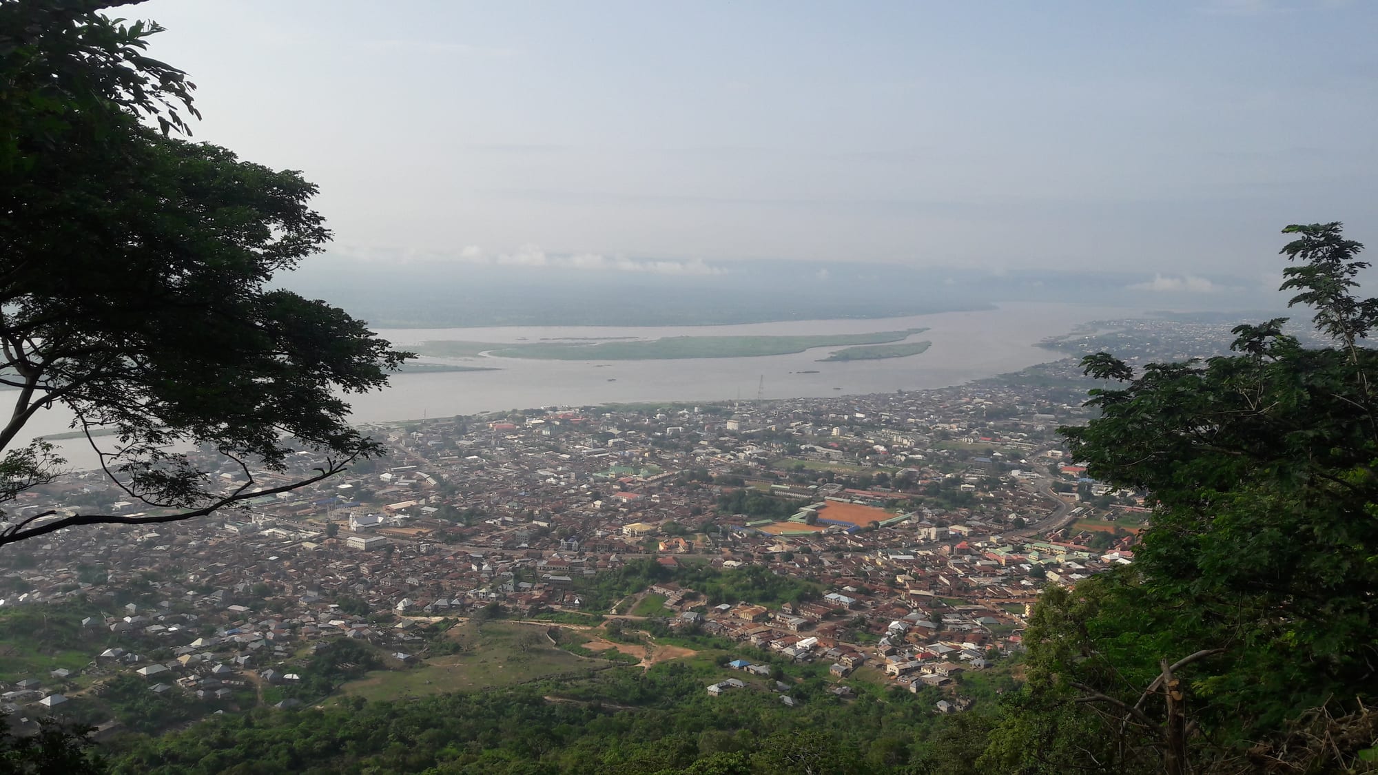
A town of low roofs spreading along the bank of a wide brown river with sandbanks, seen from a wooded hilltop

Abuja & the Middle Belt, Nigeria

Lokoja

Lokoja seen from Mount Patti, with the Niger and its sandbanks beyond the town. (Chinexfrust701 / Wikimedia Commons · CC BY-SA 4.0)

The capital of Kogi State, on the west bank of the Niger at the point where the Benue joins it — the meeting of Nigeria's two great rivers. A British base from 1857 and the first capital of the Northern Protectorate, it keeps colonial-era relics below the long ridge of Mount Patti, and remains a river crossing and highway town between Abuja and the south.

Neighbourhoods

  • The riverside old town
    • First-time visitors
    • Historic district
    • River views

    The original settlement strung along the bank of the Niger below the hill, where the colonial-era buildings, historic relics and government offices stand among markets and jetties. It is the most walkable part of Lokoja.

    Open in Maps
  • Adankolo
    • Students
    • Quiet and residential

    A northern district on the road out towards Abuja, with a university campus, schools and newer housing spread across rising ground away from the river.

    Open in Maps
  • Ganaja
    • Local life
    • Markets

    A busy residential and trading area on the southern side of the city, on the route towards the river crossing and Ajaokuta, with markets, transport parks and dense housing.

    Open in Maps
  • Felele
    • Quiet and residential
    • Close to the highway

    The southern approach to Lokoja along the Abuja–Okene highway, with newer estates, filling stations and roadside businesses serving long-distance traffic.

    Open in Maps

Things to do

Views and the rivers

  • Mount Pattiviewpoint

    A wooded hill of 458 metres above the town, known as the place from which the journalist Flora Shaw, who proposed the name Nigeria, looked out over the rivers; the confluence of the Niger and the Benue is seen laid out below.

    Open in Maps
  • The Niger–Benue confluenceviewpoint

    The point just north-east of the town where the Benue meets the Niger, the two rivers running visibly different colours for some distance after they join.

    Open in Maps
  • The river crossing and jettiestransit hub

    The riverside landings where boats and ferries work the Niger, and where the road bridge carries traffic towards the eastern bank.

    Open in Maps

Colonial-era relics

  • The Iron of Libertylandmark

    One of the historic sites of the old town, listed among the relics of Lokoja's colonial period and among its best-known landmarks.

    Open in Maps
  • Lugard's rest house on Mount Pattilandmark

    The ruined colonial rest house on the hill, associated with Frederick Lugard, the administrator who ran the Northern Protectorate from Lokoja at the start of the 20th century.

    Open in Maps
  • The site of the 1900 flag ceremonylandmark

    The spot in the old town remembered as the place where the Royal Niger Company's flag was lowered in 1900, when the British government took over its territories and the Northern Protectorate was proclaimed.

    Open in Maps

Short trips from the town

  • Ajaokutalandmark

    The river town downstream of Lokoja built around the vast, long-unfinished steel complex begun in the late 1970s, a landmark of Nigeria's industrial ambitions and their delays.

    Open in Maps

Eat and drink

Long-standing places and food districts in Lokoja. Hours, ratings and directions come from your maps app, always current.

Markets and food districts

  • Lokoja main marketmarket

    The town's central market, selling yams, cassava, peppers, palm oil and fresh and smoked river fish brought up from the landings.

    Open in Maps
  • Ganaja market areaneighborhood

    A trading area on the southern side of town with produce stalls, buka kitchens and food sellers serving the transport parks.

    Open in Maps

Street food

  • Riverside fish grillsrestaurant

    Stalls near the river and along the main roads grilling and frying catfish and tilapia from the Niger, usually served with pepper sauce.

    Open in Maps
  • Evening suya standsrestaurant

    Charcoal grills along the highway through town, selling thin skewers of beef rubbed with the peppery yaji spice mix.

    Open in Maps

Experience Lokoja

History

The confluence of the Niger and the Benue was known to river peoples long before Europeans reached it, and the surrounding country belonged to the Igala, Nupe, Ebira and Bassa. It drew outside attention in the 19th century, when British expeditions pushed up the Niger in search of a route into the interior. The naturalist and consul William Balfour Baikie, who had led an expedition up the Niger in 1854, chose the confluence as his base in 1857 — the site of a model farm abandoned after the disastrous Niger expedition of 1841 — and the trading and mission station he built there is the beginning of the modern town.

Lokoja became the main British foothold on the upper Niger. The Royal Niger Company ran its operations from here, and when the Protectorate of Northern Nigeria was proclaimed on 1 January 1900, Frederick Lugard read the proclamation and the town became the protectorate's first capital, until the headquarters moved to Zungeru in 1902. What remained was a river port of officials, soldiers, traders, freed captives and missionaries, with a cemetery, a garrison and a rest house on the hill above.

The town slipped into the background after the capital moved and the railways bypassed it, becoming a modest river and road centre. Its position on the highway between Abuja and the south kept it busy, and the creation of Kogi State in August 1991 made Lokoja a state capital once more, bringing a secretariat, a university, new districts and rapid growth. Serious flooding along both rivers, notably in 2012 and again in 2022, has repeatedly damaged low-lying parts of the town.

Culture & Customs

Lokoja is one of Nigeria's genuine crossroads. Kogi State brings together the Igala of the east bank, the Ebira of the centre, the Okun Yoruba of the west, and Nupe, Bassa and Hausa communities, and the town's markets, schools and offices mix all of them. English and Nigerian Pidgin serve as common languages, with Hausa widely understood and Igala, Ebira and Yoruba spoken at home.

Religion is mixed and visible. Churches of many denominations, some with roots in the 19th-century missions that used the town as a base, stand near mosques serving a substantial Muslim population, and both Christmas and the two Eids are marked publicly. The missionary history is part of local identity: the confluence was a landing place for clergy and freed captives heading inland, and church anniversaries recall it.

Traditional authority still matters. Communities keep their own rulers and chieftaincy titles, masquerade traditions and harvest festivals — the Igala and Ebira new-yam celebrations among them — and family ceremonies bring relatives back from Abuja and Lagos. The rivers shape a good deal of the culture too, from fishing families to boat crossings and the habit of gathering on the heights to look at the meeting of the waters. Manners are formal and hospitable, with visitors greeted and offered water or kola.

Daily Life

Lokoja's population was estimated at more than 265,000 in 2022, and the built-up area has grown quickly since it became a state capital and now stretches for several kilometres along the highway. Government is the biggest formal employer, together with the Federal University Lokoja, colleges, hospitals and the banks and offices that serve them.

Everything else depends on the road and the river. Long-distance lorries and buses between Abuja and the south stop here for fuel, food and repairs, supporting mechanics, traders and roadside kitchens. Fishing on the Niger and Benue, farming of yams, cassava, maize and rice in the surrounding country, sand dredging from the riverbed and small-scale trade fill out the local economy, with the Itakpe iron ore mines and the Ajaokuta steel complex nearby.

The day begins early, before the valley heat builds, and slows in the afternoon; markets and grills are busiest in the evening. Power cuts are frequent, so generators hum in the background, and water supply is uneven. The defining local worry is flooding: when the rivers rise at the end of the rainy season, riverside districts and farmland can be inundated, and households in the lowest-lying areas move each year. Fuel and food prices since 2023 are the other constant subject of complaint.

Food

Lokoja eats river food. Catfish, tilapia and other Niger and Benue fish are sold fresh or smoked in the markets and cooked into peppery stews and soups, or grilled whole over charcoal with a chilli rub. Pounded yam is the staple swallow, alongside eba from cassava and tuwo, the stiff grain porridge from the north, served with egusi, okra, bitterleaf or vegetable soups.

Local kitchens draw on the state's several cuisines. Igala and Bassa cooking favours yam in all forms, including yam porridge cooked with palm oil, peppers and fish, and Ebira dishes use rice, beans and locally ground grains. Apapa or beans wrapped and steamed in leaves, akara fritters, moin moin and starchy pap appear at breakfast, and roasted yam with palm oil sauce is sold at the roadside through the day.

The highway brings its own food culture: buka kitchens serving rice and stew, jollof and beans to drivers at all hours, and suya grills working late into the night. To drink there is kunu made from millet, zobo from dried hibiscus, palm wine from the surrounding villages, bottled soft drinks and beer, and sweet tea at small stalls in the morning.

Planning tools

Budget

Lokoja is inexpensive. It is a highway and government town rather than a tourist one, so hotels are simple and aimed at travellers passing through, and local food costs very little. Hiring a car or a motorcycle taxi for the climb up Mount Patti is the main extra cost.

Daily Budget Midrange
USD 70–140 (better hotel, restaurants, a car with driver)
Daily Budget Shoestring
USD 25–45 (simple hotel, local eateries, shared taxis and keke)

Carry naira in cash, as card acceptance is limited, and agree the price of a vehicle or a guide for Mount Patti before setting out.

Best Time to Visit

November to February, in the dry season, is the most comfortable, with clearer views from the hill once the harmattan haze lifts. The rains from April to October raise the rivers, and the months from August to October are the period when flooding along the Niger and Benue is most likely.

Suggested Number of Days

A day covers the old town, the river and the view from the hill. A second allows for the riverside country and the industrial sites downstream. Many travellers stop here for a night while crossing between Abuja and the south.

First Visit
1 day
With Surroundings
2 days

Transportation

Shared taxis, minibuses and three-wheeled keke napep run along the main road through town, and motorcycle taxis climb the roads towards Mount Patti. The Abuja–Okene highway carries heavy lorry traffic through the centre, and boats work the river between the banks and to nearby villages.

Arrange a car or a motorcycle taxi through a hotel or trusted local contact, and avoid road travel between towns after dark.

Airport & Station Connections

Lokoja has no commercial airport; the nearest is at Abuja, a few hours north by road. The town sits on the main highway between Abuja and the south-east and south-west, so buses and shared cars pass through constantly, and the Warri–Itakpe railway reaches Itakpe, to the south-west.

Walkability

The old riverside town is compact and can be seen on foot, with the market, the old colonial quarter and the river within a short distance of each other. The city as a whole is stretched along the highway, the heat is heavy, pavements are scarce, and the climb up Mount Patti is a road route rather than a footpath, so a vehicle is needed for anything outside the centre.

Safety

Lokoja is a busy highway town, calmer than the rural parts of the zone, but robbery and kidnapping have occurred on the highways through Kogi State, and governments advise against travel to parts of the region. Flooding is a seasonal hazard for the low-lying districts, and ordinary urban theft occurs in crowded places.

Stay within central Abuja or travel with trusted local guidance, avoid rural areas of Benue, Plateau and Niger States, and never drive between cities at night. Check current official travel advice before travelling.

Climate

Hot tropical savanna in a river valley that holds the heat, with one rainy season from about April to October and a dry season from November to March, including the harmattan haze from December to February.

Summer
rainy season, roughly 23–32°C, humid with heavy storms and rising rivers
Winter
dry season, roughly 20–37°C, very hot afternoons and dusty air

Local Customs

Kogi is a meeting point of the Igala, Ebira, Okun Yoruba, Nupe, Bassa and other communities, and both Christianity and Islam are strongly present. Greetings are unhurried, elders are addressed first, and modest dress is expected in the markets, churches and mosques.

Ask before photographing people, the river landings, bridges or official buildings, and ask permission locally before walking on Mount Patti.

Common Payment Methods

The currency is the naira. Cash is used for almost everything, and small notes matter for transport and market purchases. Cards work only in the larger hotels, bank transfers are common among residents, and ATMs in the centre can be unreliable for foreign cards.