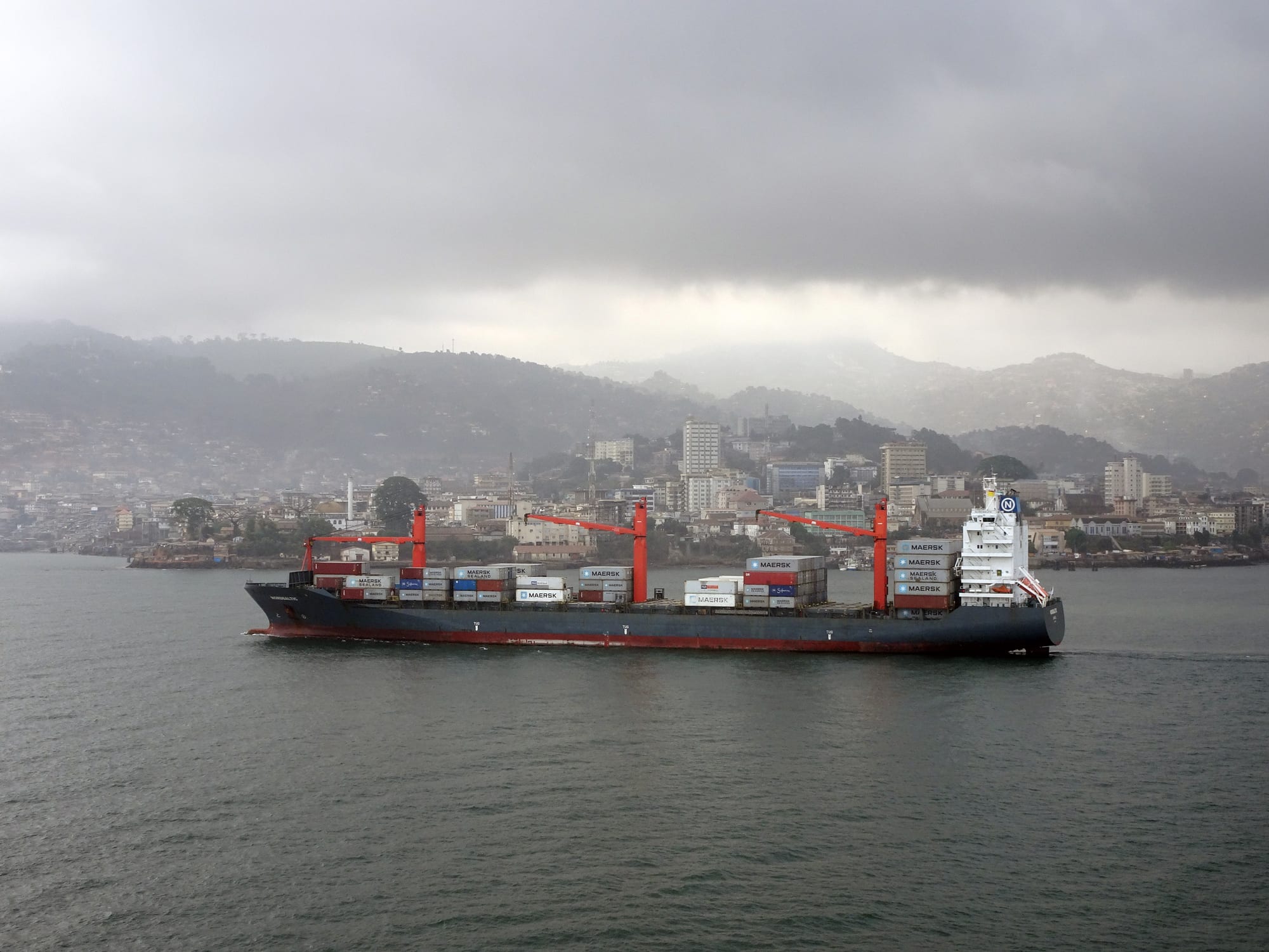
A container ship crossing grey water in front of Freetown, with low waterfront buildings and green hills covered in houses rising behind under heavy cloud

Freetown & the North, Sierra Leone

Freetown

A container ship entering the port of Freetown, with the city and its mountains behind. (Alacoolwiki / Wikimedia Commons · CC BY-SA 4.0)

Sierra Leone's capital, built on a narrow shelf between forested mountains and the largest natural harbour in Africa. Founded as a settlement for freed and formerly enslaved Africans in the late eighteenth century, it grew into the home of the Krio people and their language, and is now a crowded port city with beaches along the peninsula to the south.

Neighbourhoods

  • Central Freetown
    • First-time visitors
    • Historic district
    • Markets

    The old colonial grid between the harbour and the hills, along Siaka Stevens Street and Wallace Johnson Street. Government buildings, banks, the National Museum, the law courts and the biggest markets are here, and traffic and street trading fill the pavements from early morning.

    Open in Maps
  • Aberdeen
    • Nightlife
    • Best for food
    • Beaches

    A low peninsula in the west of the city, reached across the creek bridge, with most of the hotels, restaurants and bars used by visitors, business travellers and aid workers. The water-taxi jetties for the airport are here, and Lumley Beach runs south from it.

    Open in Maps
  • Lumley and Murray Town
    • Beaches
    • Close to public transport

    The western suburbs facing the Atlantic, strung along the beach road. Lumley is a busy junction for shared taxis heading out of the city and to the peninsula beaches, and the sand is where much of Freetown walks, exercises and eats fish in the evening.

    Open in Maps
  • Hill Station and Wilberforce
    • Quiet and residential
    • Views

    Cooler ground above the city, laid out in colonial times as a hill retreat and still lined with embassies, residences and a few surviving wooden bungalows. The roads climb steeply, and views open over the harbour and the estuary.

    Open in Maps
  • The East End
    • Local life
    • Markets

    The densely built eastern districts around Kissy and Wellington, running towards the ferry terminal and the industrial waterfront. This is where much of the city's working population lives, in some of the oldest recaptive villages absorbed by the growing city.

    Open in Maps
  • The mountain villages
    • Quiet and residential
    • Walks

    Regent, Gloucester, Leicester and Charlotte sit in the hills behind Freetown, founded in the early nineteenth century for Africans freed from slave ships. Small stone churches, cool air and forest paths make them a contrast to the city below.

    Open in Maps

Things to do

Landmarks and historic sites

  • Cotton Treelandmark

    The great kapok tree beside the museum that stood as the symbol of the city and of the settlers' arrival until it came down in heavy rain on 24 May 2023; part of the trunk is still alive on the site, and the fallen wood was taken to a museum.

    Open in Maps
  • St George's Cathedrallandmark

    The Anglican cathedral in the centre of the city, begun in 1817 and completed in 1828, and now the cathedral church of the Diocese of Freetown.

    Open in Maps
  • King's Yard Gatelandmark

    A stone gateway in the centre of the city, inscribed that any slave who passes through it is declared a free man, through which Africans freed from intercepted slave ships were received into the colony.

    Open in Maps
  • Old Fourah Bay College buildinglandmark

    The surviving shell of the 1840s college building at Cline Town, the first Western-style university institution in sub-Saharan Africa, founded in 1827.

    Open in Maps
  • Krio board houseslandmark

    Wooden-framed settler houses with shingled roofs, shuttered upper storeys and stone cellars, scattered through the older streets of the city centre.

    Open in Maps

Museums

  • Sierra Leone National Museummuseum

    The national collection beside the site of the Cotton Tree, opened in 1957 and made the national museum in 1967, with masks, ritual objects and displays on the settlement and independence.

    Open in Maps
  • National Railway Museummuseum

    Restored locomotives and carriages of the dismantled Sierra Leone Government Railway in a former workshop at Cline Town.

    Open in Maps

Hills and wildlife

  • Tacugama Chimpanzee Sanctuaryattraction

    A sanctuary for rescued and orphaned chimpanzees in the peninsula's rainforest reserve above the city, a few miles from the centre, with guided visits and forest trails.

    Open in Maps
  • Western Area Peninsula National Parkpark

    The rainforest covering the mountains behind Freetown, protecting the city's watershed along with chimpanzees, duikers and many birds.

    Open in Maps

Beaches

  • Lumley Beachbeach

    A long strip of sand along the western edge of the city, lined with bars and fish grills and busiest at sunset.

    Open in Maps
  • Aberdeen Beachbeach

    The sheltered sand at the northern end of the Lumley strip, below the hotels of the Aberdeen peninsula.

    Open in Maps

Short trips from the city

  • Tokeh Beachbeach

    A wide beach backed by palms on the western side of the peninsula, with fishing boats drawn up on the sand and a few lodges.

    Open in Maps
  • River No. 2 Beachbeach

    A beach on the western side of the peninsula where a river runs out into the sea, looked after by a community project of the villagers.

    Open in Maps
  • Bunce Islandlandmark

    The ruins of a British slave-trading castle, from which captives were shipped to the rice plantations of South Carolina and Georgia.

    Open in Maps
  • Bureh Beachbeach

    A village beach on the south of the peninsula known for the surf club that gives it the country's surfing reputation.

    Open in Maps

Seasonal events

  • Christmas and Easter masqueradesDecember and April

    Krio and other societies parade through the streets in costume with drums, dancing and brass, drawing crowds across the city.

  • Independence DayApril

    Parades, school displays and street celebrations marking independence from Britain in 1961.

  • Eid al-Fitr and Eid al-Adhavaries with the lunar calendar

    Mass prayers at the mosques and open grounds of the city, followed by family visiting that crosses religious lines.

  • Lumley Beach New Year gatheringslate December and 1 January

    The beach fills with families, music and food stalls over the New Year holiday, one of the biggest outdoor gatherings of the year.

Eat and drink

Long-standing places and food districts in Freetown. Hours, ratings and directions come from your maps app, always current.

Freetown classics

  • Cassava leaf and rice at a chop barrestaurant

    Pounded cassava leaf stewed with palm oil, groundnut and smoked fish over rice is the standard midday plate, sold from small kitchens across the centre.

    Open in Maps
  • Grilled fish on Lumley Beachneighborhood

    Barracuda, snapper and bonga grilled over charcoal at the beach bars along the western shore, usually served with fried plantain or chips.

    Open in Maps
  • Poyo barscafe

    Informal bars serving poyo, the tapped palm wine brought in from the peninsula villages each morning and drunk fresh.

    Open in Maps

Markets and food streets

  • Big Marketmarket

    A covered market near the waterfront known for crafts, cloth and household goods, with food traders in the surrounding streets.

    Open in Maps
  • Central market streetsneighborhood

    Sansi, Kroo Bay and the pavements along Wallace Johnson Street carry fish, cassava, rice, peppers and palm oil in from the peninsula and the provinces.

    Open in Maps
  • Aberdeen restaurantsneighborhood

    The cluster of Lebanese, Indian, Chinese and Sierra Leonean restaurants around the hotels of the Aberdeen peninsula, the main concentration of restaurants in the city.

    Open in Maps

Experience Freetown

History

Freetown began with two landings. In 1787 British abolitionists put ashore about 400 poor Black Londoners and others on the shore of the peninsula, founding Granville Town, which disease and a Temne attack all but destroyed. In 1792 some 1,200 Black Loyalists, Africans who had sided with Britain in the American Revolution and been resettled in Nova Scotia, landed under Thomas Peters and John Clarkson and laid out the streets of Freetown. Jamaican Maroons followed in 1800. After Britain abolished the slave trade in 1807 and the settlement became a Crown colony in 1808, the Royal Navy's West Africa Squadron brought tens of thousands of Africans freed from intercepted slave ships into the harbour, and they were settled in villages around the mountains — Regent, Gloucester, Waterloo, Kissy.

From this mixture grew the Krio, a people with their own English-based language, church life and architecture. Fourah Bay College, founded in 1827, drew students from across British West Africa and gave the city its old reputation as a centre of learning. Freetown's harbour made it a naval station, used heavily as a convoy assembly point in both world wars.

After independence in 1961 the city grew far beyond its colonial frame. The civil war of 1991–2002 reached it directly in January 1999, when AFRC and RUF forces attacked the city and over 7,000 people were killed, at least half of them civilians. Recovery since has been steady but interrupted: the Ebola epidemic of 2014–16, a mudslide at Regent in 2017 that left about 1,100 people dead or missing, repeated floods, and the loss of the old Cotton Tree, which fell in a storm in May 2023.

Culture & Customs

Freetown is the home of Krio culture, and although Krio people are only a small part of the population, their language is spoken by almost everyone in the city and across the country. The Krio year turns on church, the awujoh feast for the ancestors, and the masquerade societies whose costumed processions — hunting societies, Ode-lay groups, the Christmas and Easter parades — fill the streets with drums and brass. The steep-roofed wooden board house, with its shuttered balcony and stone cellar, is the city's own architecture.

The population is far broader than that: Temne and Limba from the north, Mende from the south, Fula and Mandingo traders, and Lebanese families settled for generations. Muslims are the majority and Christians a large minority, and the two mix to an unusual degree, sharing weddings, funerals and holidays, with mosques and churches on the same street. Poro and Bondo society membership persists in the neighbourhoods that grew from the mountain villages.

Music runs from palm-wine guitar and the maringa of Ebenezer Calender through gumbe drumming to a loud contemporary scene of Afrobeats and rap that argues over politics and hardship. Football is the mass passion, played on any flat ground and watched at the national stadium at Brookfields. Manners are formal in a way visitors notice: greetings before requests, respect for elders, and a general readiness to talk.

Daily Life

About 1.35 million people were counted in Freetown at the 2024 census, the great majority of them packed onto a narrow shelf between the mountains and the sea and spreading up the hillsides and out along the shore. The day begins before dawn, because the few roads linking the east end, the central business district and the western suburbs seize up by seven; traders set out at first light and much of the city's business is done by early afternoon.

Most households live on trade and small enterprise — market stalls, street selling, okada riding, workshops — while formal jobs come from the port, the ministries, banks, telecoms, aid agencies and mining companies. Money from relatives in Britain and the United States supports many families. Power cuts and water shortages are routine, and informal settlements on the shoreline at Kroo Bay and Susan's Bay and on the steep slopes flood or slip in the rains.

The city is run by a directly elected council headed by a mayor, chosen every four years, and flooding, landslides and building on the steep slopes are its recurring problems. Pressure on the forest above the city, the spread of the synthetic drug known as kush among young people, and the cost of imported rice and fuel are the issues people discuss.

Food

Rice is the meal, and everything else is what goes on it. The daily plate is plasas — a thick, oily leaf sauce — over white rice: cassava leaf pounded fine and cooked long with red palm oil, groundnut paste and smoked or fresh fish, or potato leaf, krain krain made from jute leaf, or okra. Groundnut stew and pepper soup are everyday alternatives, and jollof rice appears at any celebration. Fufu and gari from cassava come with soups in Krio and provincial households alike.

The sea sets Freetown apart from the interior. Bonga, barracuda, snapper and lobster are landed at Tombo and the peninsula villages and grilled over charcoal at the beach bars along Lumley, usually with fried plantain and pepper sauce. Krio cooking adds its own dishes: black-eyed beans and rice, jollof, fried fish with pepper, and the awujoh table of beans, plantain and rice flour foods laid out for the ancestors.

Street food is constant. Akara bean fritters and binch akara, roasted groundnuts, fried plantain and cassava, rice bread, and sweet fried dough are sold from head trays and stalls through the day. Ginger beer is made strong and sweet, poyo palm wine arrives fresh from the villages each morning, Star is the local beer, and green tea with condensed milk is drunk at roadside stands, especially by traders from the north.

Planning tools

Budget

Freetown is the most expensive place in Sierra Leone. Rice and sauce from a chop bar, shared taxis and poda-podas cost very little, but hotel rooms, imported food and drink in Aberdeen, and a car with a driver for the peninsula are priced for business and aid visitors. The airport transfer across the estuary is a fixed extra on any trip.

Daily Budget Midrange
USD 100–220 (hotel in Aberdeen or Lumley, restaurant meals, a car with driver for beach trips)
Daily Budget Shoestring
USD 30–55 (guesthouse room, chop bar meals, poda-podas and shared taxis)

Carry cash in leones for anything outside the main hotels, and budget separately for the water taxi or sea coach to the airport.

Best Time to Visit

November to April, the dry season, is the comfortable time for the beaches and for road trips out of the city. December to February is coolest, with harmattan haze; March and April are very hot and humid. The rains from June to September are among the heaviest in West Africa and flood parts of the city.

Suggested Number of Days

Two or three days cover the centre, the museums and an afternoon on the beach. Four to six make sense for the peninsula beaches, the forest above the city and a boat trip in the estuary. Traffic is the main constraint, so allow more time than the distances suggest.

First Visit
2–3 days
With Surroundings
4–6 days

Transportation

Movement is by shared taxi, poda-poda minibus and okada motorbike taxi, all running set routes along the few main roads; private taxis can be chartered for a journey or a day. Congestion is severe between the east end, the centre and the western suburbs, and the mountain roads are steep and rough in the rains. Government buses and ferries also serve the east of the city.

Charter a private taxi rather than sharing at night, and allow well over an hour to cross the city at peak times.

Airport & Station Connections

Freetown International Airport is at Lungi, across the Sierra Leone River estuary from the city. Most arrivals cross by water taxi, fast boat or ferry from Aberdeen; the road route around the estuary takes about five hours. Long-distance buses and shared taxis run to Makeni, Bo and Kenema, and to Conakry in Guinea.

Walkability

The central grid is walkable, and the museums, cathedral and markets sit within a few blocks of one another, though pavements are crowded, uneven and often taken up by traders. Beyond the centre the city is long, steep and strung out, so walking between districts is impractical; Lumley Beach is the one long, easy walk.

Safety

The city is peaceful, and violent crime against visitors is uncommon, but pickpocketing and bag snatching happen in the markets, the business district and on Lumley Beach after dark, with occasional armed robbery at night. Traffic and okada accidents are a real risk, rip currents run off the peninsula beaches, and heavy rain brings flooding and landslides on the hillsides.

Don't display phones or valuables, use private taxis at night, take malaria precautions, drink bottled or treated water, and carry comprehensive insurance with medical evacuation cover. Check current official travel advice before travelling.

Climate

Tropical, hot and humid all year, with one long rainy season. The mountains behind the city wring extreme rainfall out of the monsoon, making Freetown one of the wettest capitals in Africa, while the dry months are hazy with harmattan dust.

Summer
the wet season, about 24–30°C, with torrential rain in July and August and days of unbroken cloud
Winter
the dry season, about 25–33°C, hazy from December to February and hottest in March and April

Local Customs

Greetings matter and come before business: a handshake and a few words in Krio are expected. Muslims and Christians share festivals and families, and both are treated with respect. Dress is modest in town, and beachwear stays on the beach. Elders are addressed with deference, and photographing people, government buildings, the port or the airport without permission causes trouble.

Ask before photographing people, avoid photographing official buildings, and tip modestly in restaurants where service is not included.

Common Payment Methods

The currency is the leone (SLE), redenominated in 2022. Sierra Leone runs on cash: notes are needed for taxis, markets and most meals. Cards are accepted at a small number of hotels and supermarkets, and ATMs are concentrated in the centre and Aberdeen, so many visitors bring US dollars to change.