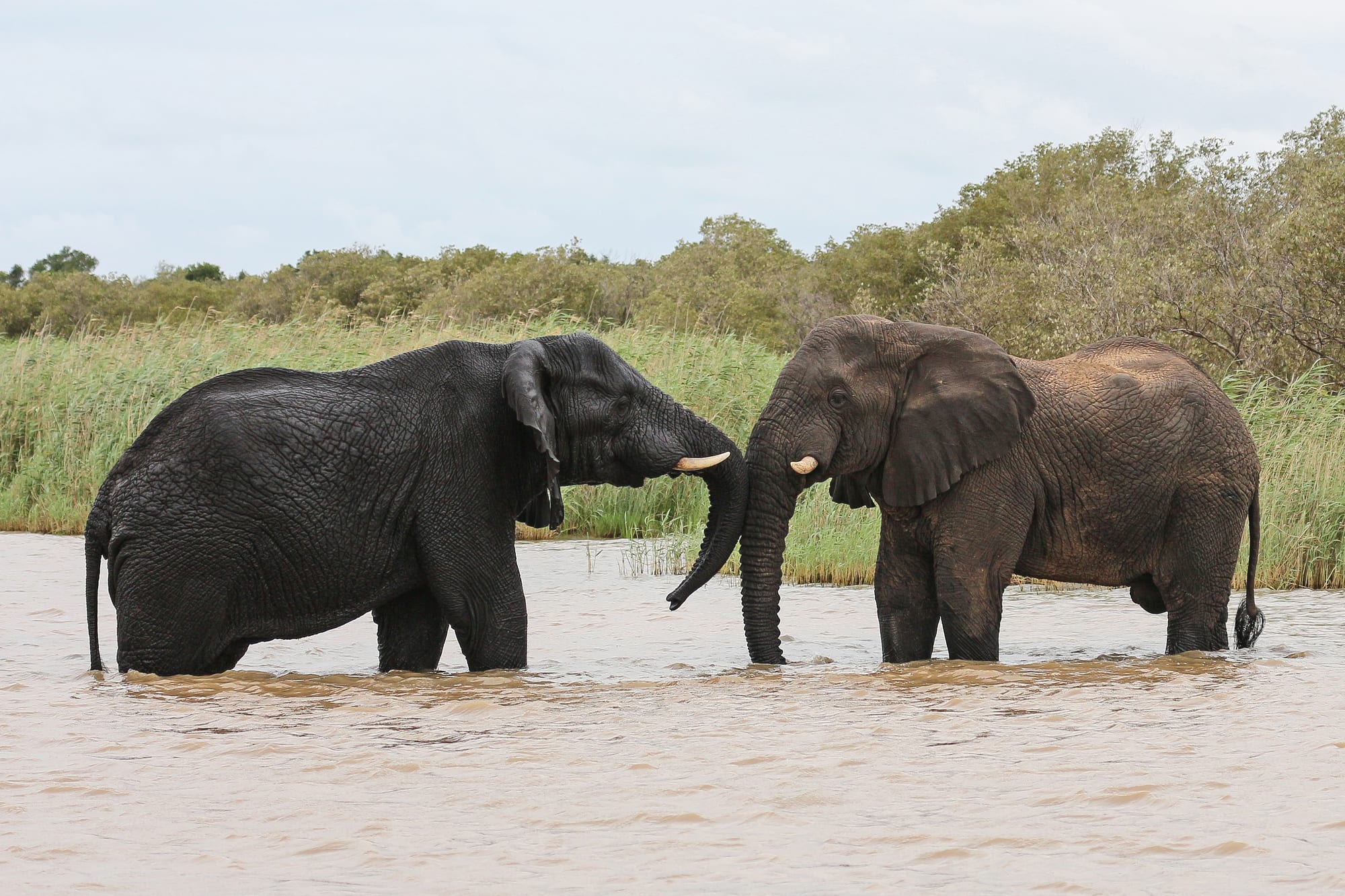
Two elephants standing chest-deep in brown estuary water in front of tall reeds and coastal bush

Durban & KwaZulu-Natal, South Africa

St Lucia

Elephants in the shallows of the Lake St Lucia estuary, inside iSimangaliso Wetland Park. (Bernard Gagnon / Wikimedia Commons · CC BY-SA 4.0)

A small town on the estuary at the southern end of iSimangaliso Wetland Park, in subtropical northern KwaZulu-Natal. Founded as a fishing and holiday village, it now lives almost entirely from the wetland park around it — boat trips among hippos and crocodiles, game drives on the Eastern Shores, and beaches where turtles nest in summer.

Neighbourhoods

  • The village centre
    • First-time visitors
    • Best for food
    • Close to the boats

    A handful of streets around McKenzie Street, the main road in, holding almost every shop, restaurant, tour desk and guesthouse in the town. Everything is within a few minutes' walk, and the bush begins at the end of the side roads.

    Open in Maps
  • The estuary side and the park gates
    • Quiet and residential
    • Wildlife
    • Boat trips

    The edge of town facing the water, where the jetties for the estuary cruises and the entrance to the Eastern Shores section of the park are found. Houses back onto dense coastal forest, and hippos come out of the water to graze the verges at night.

    Open in Maps

Things to do

The estuary and the village

  • St Lucia Estuary boat tripsattraction

    Flat-bottomed boats run from the jetties into the estuary among hippo pods, crocodiles, fish eagles and pelicans, the town's defining activity.

    Open in Maps
  • The estuary mouth and beachbeach

    The sandy mouth where the lake system meets the Indian Ocean, a short walk or drive from the village, with long open beach either side and strong surf.

    Open in Maps
  • St Lucia Crocodile Centreattraction

    A centre in the village where live crocodiles and snakes are kept on display, a close look at the reptiles that bask along the estuary banks.

    Open in Maps

iSimangaliso Wetland Park

  • iSimangaliso Wetland Parkpark

    Declared a UNESCO World Heritage Site in 1999 and South Africa's third-largest protected area, covering 280 km of coastline and some 3,280 square kilometres of lake, swamp forest, dune and reef, with about 800 hippos, 1,200 crocodiles, elephant, rhino and vast numbers of birds.

    Open in Maps
  • The Eastern Shorespark

    The park section reached directly from the village, with self-drive loops through grassland and dune forest where zebra, buffalo, kudu and warthog are common.

    Open in Maps
  • Cape Vidalbeach

    A sheltered bay inside the park about 30 km north of town, with a coral-backed beach, snorkelling and a rest camp among the dunes.

    Open in Maps
  • Mission Rocksviewpoint

    A rocky shore and lookout on the Eastern Shores road, with tidal pools at low water and a view from the dune ridge over lake and sea at once.

    Open in Maps

Short trips from the town

  • Hluhluwe-iMfolozi Parkpark

    The oldest game reserve in Africa, 960 square kilometres of hilly Zululand where the southern white rhino was bred back from near extinction and all of the big five can be seen.

    Open in Maps

Seasonal events

  • Turtle nesting seasonSummer

    Loggerhead and leatherback turtles come ashore to lay eggs on the park's northern beaches in the summer months, and guided night drives are run to watch them.

  • Whale seasonWinter and spring

    Whales pass along the coast on their migration, visible from the dunes and from boat trips out of the estuary; dolphins and whale sharks are also seen offshore.

Eat and drink

Long-standing places and food districts in St Lucia. Hours, ratings and directions come from your maps app, always current.

St Lucia classics

  • McKenzie Streetneighborhood

    The village's restaurants, pubs and coffee shops stand along one street, most of them serving seafood, grills and burgers to visitors between park trips.

    Open in Maps
  • Seafood and prawnsrestaurant

    Prawns, line fish and calamari, often cooked with peri-peri in the Mozambican manner that runs down this coast, are the local staple.

    Open in Maps
  • Zulu and township foodneighborhood

    Phuthu maize porridge with amasi, amadumbe and meat grilled over coals are eaten in the villages around the town, and some tour operators include a meal on cultural visits.

    Open in Maps

Experience St Lucia

History

The lake and estuary have carried the name St Lucia since Portuguese navigators charted the coast — the mouth was renamed Santa Lucia on the feast of Saint Lucy in December 1575 — but the country around it was Zulu, and the lake and its surrounding forests were long used for fishing and hunting. The first colonial protection followed in 1895, when parts of St Lucia were proclaimed a game reserve, making it one of the oldest protected areas in Africa and the oldest formally protected estuary in the world.

The modern village grew slowly in the twentieth century as a fishing and holiday settlement at the estuary mouth, reached by a long road off the main coastal route. Commercial forestry, mostly plantations of pine and eucalyptus laid out from the 1950s, covered much of the dune country behind it; some 23,000 hectares have been cleared from the Eastern and Western Shores since the early 1990s and the land rehabilitated. The lake, with the turtle beaches and coral reefs of Maputaland, has been listed under the Ramsar Convention since 1971.

The protected areas around the lake were consolidated and declared a UNESCO World Heritage Site in December 1999, then named the Greater St Lucia Wetland Park and renamed iSimangaliso in November 2007. The village turned almost entirely to tourism. Engineers had cut the Mfolozi River off from the system in 1952, and the estuary mouth closed to the sea in June 2002 and stayed shut for four years and nine months, concentrating salt in the lake and killing fish and birdlife. The two systems were formally rejoined in 2012, and in January 2021 the mouth was opened to the sea again, an event closely followed by everyone who lives here.

Culture & Customs

St Lucia is a park village, and its culture is built around the bush. Guides, boat skippers, rangers and lodge staff make up much of the working population, and conversation turns on water levels, the state of the mouth, where the elephants have been seen and when the turtles began to come ashore. Most guides are Zulu and have grown up in the villages around the park, and guiding qualifications are a recognised career route in a district with few other jobs.

The surrounding countryside is deeply Zulu. Homesteads, cattle and traditional authorities govern life outside the village, and isiZulu, clan names and respect for elders shape everyday manners. Community trusts hold land claims inside the park, and a share of park revenue and employment goes to the neighbouring communities — an arrangement that is a continuing subject of local debate.

Visitors bring a second culture: South African families on school holidays, overland travellers on the route between Durban and the Kruger area, and birdwatchers and divers heading north to Sodwana Bay. The village is easy-going and small enough that everybody knows the operators by name. Evenings are quiet, partly by preference and partly because hippos own the streets after dark — a fact residents treat as ordinary and repeat to every new arrival.

Daily Life

A few thousand people live in the village, with larger communities in the settlements along the road inland. Almost every household depends on the wetland park in some way: guiding, boat operation, guesthouses, restaurants, cleaning and maintenance, park staff and the crafts sold at roadside stalls. Sugar cane and forestry provide work further inland, and Richards Bay's port and industries draw commuters from the wider district.

The season shapes the year. School holidays fill every bed and empty the supermarket shelves; the quiet weeks of late autumn and early spring are when maintenance is done and staff take leave. Off-season, the village is very quiet by early evening. Water, electricity and the condition of the road in are recurring local concerns, along with the health of the estuary itself.

Living beside big game is routine. Hippos graze gardens and verges at night, crocodiles are in the estuary, and monkeys raid kitchens; fences, gates and night-time lifts between guesthouses and restaurants are part of ordinary life. Malaria precautions are normal in summer. The conservation authority runs education and job schemes with the neighbouring communities, and the balance between park protection, land claims and local livelihoods is the standing political question of the district.

Food

Fish and prawns dominate. Line fish from the coast, prawns and calamari cooked with garlic, lemon or peri-peri in the Mozambican style that runs down this shore, and fish and chips in the village restaurants are what most visitors eat. Angling is a long-standing pastime here, though fishing is regulated closely inside the park and prohibited in some sections.

Zulu food is the everyday cooking of the district: phuthu, the dry crumbly maize porridge, eaten with amasi, soured milk, or with a stew; amadumbe, the taro-like root grown along this coast, boiled or roasted; beans, pumpkin and wild greens known as imifino; and meat grilled over coals at shisa nyama stands, served with chakalaka relish. Umqombothi, the thick maize and sorghum beer, belongs to ceremonies rather than restaurants.

The subtropical north grows bananas, pineapples, mangoes, litchis and macadamias, sold from stalls along the N2, and sugar cane fields run for kilometres either side of the road; pieces of cut cane are sold to chew. Restaurant menus also carry the national standards — steak, boerewors, bobotie, biltong at the shop counter — and South African wines and local lagers are drunk on the verandas at sunset.

Planning tools

Budget

St Lucia is cheap for a national-park base. Guesthouses and self-catering flats in the village cost far less than lodges inside private reserves, supermarket shopping is easy, and the main expenses are boat trips, game drives and the daily conservation fee for the park. Prices climb over the December, Easter and July school holidays.

Daily Budget Midrange
USD 120–280 (guesthouse or park chalet, car hire, restaurant meals, guided game drives and boat trips)
Daily Budget Shoestring
USD 40–70 (backpacker or self-catering room, supermarket food, estuary cruise, self-drive on the Eastern Shores)

A hire car and a day permit cover the Eastern Shores loops without a guide; the estuary cruise is the one paid activity nearly everyone takes.

Best Time to Visit

May to September is dry, warm and mild, with the best game viewing, the least humidity and the lowest malaria risk, and whales offshore. Summer, from November to February, is hot, humid and wet but brings the turtle nesting season and the greenest landscape. Easter and the December holidays fill the village.

Suggested Number of Days

Two days is the usual stay, enough for the estuary and the nearest park section. Three or four allow for the coast further north and the game reserves inland. Travellers on a longer Zululand circuit often use the village as a base for a week.

First Visit
2 days
With Surroundings
3–4 days

Transportation

The village is small enough to walk in daylight, but everything else needs a vehicle: the park gates, the beaches and the reserves inland are all a drive away. Most visitors arrive by hire car. Shuttles run from Durban and Richards Bay, and local operators collect guests from their guesthouses for drives and cruises, so a stay without a car is possible.

Do not walk between the village and the estuary after dark — hippos leave the water to graze at night and are dangerous when a person blocks their route back.

Airport & Station Connections

St Lucia lies off the N2 about 250 km north of Durban, a drive of roughly three hours, and about 70 km north-east of Richards Bay, which has the nearest airport with scheduled flights. Most visitors drive from Durban or arrive as part of a Zululand circuit; shuttle services and tour transfers cover the route for those without a car.

Walkability

The village itself is flat and compact, and its shops, restaurants and jetties are a few minutes apart on foot by day. Walking is discouraged after dark because of hippos in the streets, and there are no pavements on the roads out of town. The park's trails and boardwalks provide the walking, with a guide required in some sections.

Safety

Crime is not the main concern in a village this size, though normal precautions apply. Wildlife is: hippos and crocodiles are present in and beside the estuary, hippos move through the town at night, and the beaches have strong currents and no shark nets. The area carries a low malaria risk.

Avoid Durban's city centre after dark, swim between the flags at netted beaches, register routes with the park office before Drakensberg hikes, and ask a doctor about malaria for the far north. Check current official travel advice before travelling.

Climate

Subtropical and humid, warmer and wetter than the coast further south, with most rain falling in the summer half of the year. In the southern hemisphere summer runs from December to February and winter from June to August; the sea is warm enough for swimming all year.

Summer
hot and very humid — 26–34°C with heavy showers and thunderstorms
Winter
warm and dry — 12–26°C, sunny days and cool nights

Local Customs

isiZulu is the first language of most residents, with English used in the tourism trade and Afrikaans heard among South African holidaymakers. The village is informal — shorts, sandals and early nights — and the surrounding countryside is traditional Zulu land where elders are greeted first and permission is asked before photographing people or homesteads.

Tip guides, boat crews and trackers at the end of an outing, tip about 10 per cent in restaurants, and keep to marked paths and vehicle rules inside the park.

Common Payment Methods

The currency is the South African rand. Cards are accepted by guesthouses, restaurants, the supermarket and most tour operators, and there are ATMs in the village. Cash is useful for tips, roadside stalls and craft sellers, and for the smaller settlements on the roads inland.