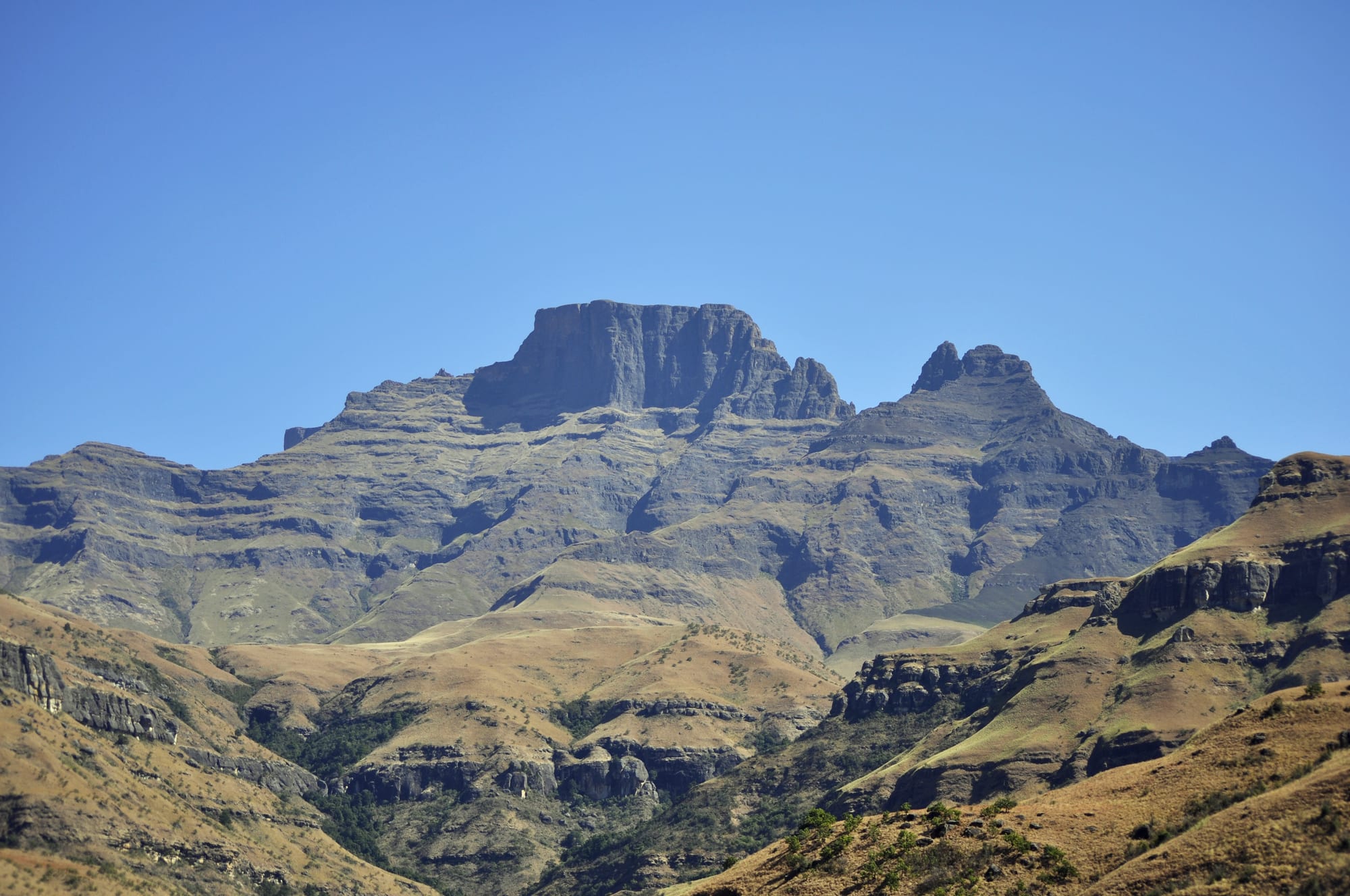
A flat-topped rock buttress and pointed peak rising above golden grass slopes and cliff bands under a clear blue sky

Durban & KwaZulu-Natal, South Africa

Winterton

Monk's Cowl and the peaks of the central Drakensberg, in the mountains above Winterton. (Darren Glanville from Acle, Norfolk, UK / Wikimedia Commons · CC BY-SA 2.0)

A small farming town in the upper Tugela valley of KwaZulu-Natal, laid out in the early twentieth century among maize fields and dairy farms. It is the road junction for the central Drakensberg — the Champagne Valley, Monk's Cowl and Cathedral Peak all turn off nearby — and serves the resorts, hiking trails and San rock-art sites of the escarpment above it.

Neighbourhoods

  • The town centre
    • First-time visitors
    • Supplies
    • Local life

    A few blocks of shops, banks and farm suppliers around the main street, where the roads to the mountain valleys meet. It is where farmers and mountain lodges buy their supplies, busiest on market and payday mornings and quiet by late afternoon.

    Open in Maps
  • The Champagne Valley
    • Mountain views
    • Walks and hiking
    • Families

    The R600 valley running south-west from the town towards the escarpment, about 20 km of guest farms, craft studios, art galleries and small breweries strung along the road below Cathkin Peak and Champagne Castle. Almost all the area's visitor accommodation is here or in the neighbouring valleys.

    Open in Maps
  • The farms and the river
    • Quiet and residential
    • Fishing
    • Birdwatching

    The flat country around the town, where the Tugela and its tributaries cross maize lands, dairy pasture and wetlands. Scattered farmsteads, the Zulu settlements beyond them and the dam to the north-west make up the everyday landscape.

    Open in Maps

Things to do

In and around the town

  • Drakensberg Boys Choir Schoolattraction

    A choir school founded in 1967 in the valleys below the central Drakensberg, whose choir tours internationally and gives weekly concerts in its own auditorium.

    Open in Maps
  • Spioenkop Dam Nature Reservepark

    A reserve of about 4,400 hectares around a dam north of the town, proclaimed in 1975, with walking trails and water sports; the Spioenkop battlefield hill stands on its northern boundary.

    Open in Maps

The central Drakensberg

  • uKhahlamba-Drakensberg Parkpark

    The basalt escarpment park, linked with Lesotho's Sehlabathebe National Park as a World Heritage Site in 2001, holding the largest concentration of San rock paintings in Africa.

    Open in Maps
  • Monk's Cowltrail

    A peak and a park entrance at the head of the Champagne Valley, the starting point for day walks to waterfalls and pools and for longer routes up towards the escarpment.

    Open in Maps
  • Champagne Castleviewpoint

    One of the highest peaks in South Africa, on the border ridge with Lesotho, standing behind the sharper spire of Cathkin Peak at the head of the valley.

    Open in Maps

Short trips from the town

  • Cathedral Peakviewpoint

    A free-standing peak of 3,004 metres on a ridge set at right angles to the main escarpment, the centre of an area of hiking trails and rock-art shelters.

    Open in Maps
  • Spioenkop battlefieldlandmark

    The hilltop where British and Boer forces fought a costly battle in January 1900 during the relief of Ladysmith, with trenches, graves and memorials still on the summit.

    Open in Maps
  • Royal Natal National Parkpark

    The park below the Amphitheatre, a curved wall of cliff several kilometres long over which the Tugela Falls drop, with walks up the gorge from the valley floor.

    Open in Maps
  • Bergvilleattraction

    The neighbouring farming town about 25 km north-west by road, the service centre for the northern Drakensberg valleys and the road to the Amphitheatre.

    Open in Maps

Eat and drink

Long-standing places and food districts in Winterton. Hours, ratings and directions come from your maps app, always current.

Winterton classics

  • The Champagne Valley roadneighborhood

    Farm stalls, coffee shops, a craft brewery and country restaurants are spread along the R600 between the town and the mountains, most of them attached to studios or guest farms.

    Open in Maps
  • Farm produce and dairymarket

    The district's cheeses, milk, trout, honey, jams and biltong are sold from farm gates and stalls, and trout from the mountain streams appears on most local menus.

    Open in Maps
  • Town cafés and takeawaysneighborhood

    The main street has a handful of cafés, bakeries and takeaways serving farmers, lodge staff and passing travellers — pies, boerewors rolls, pap and stew.

    Open in Maps

Experience Winterton

History

San hunter-gatherers lived in the Drakensberg foothills for thousands of years and left painted shelters throughout the valleys above the town, among the richest concentrations of rock art in the world. Nguni-speaking farmers settled the upper Tugela valley, which became part of the Zulu kingdom's sphere in the early nineteenth century. Voortrekkers crossed the escarpment into this country in 1837, and the valley was farmed by settlers after Britain annexed Natal in 1843.

The district's best-known event came in the South African War. In January 1900 a British force fighting its way towards besieged Ladysmith seized the hill the Boers call Spioenkop, north of the present town, and found at dawn that it was overlooked from higher ground. The day's fighting killed and wounded large numbers on the exposed summit and ended in British withdrawal. Among those present in the campaign were Winston Churchill, Mohandas Gandhi as a stretcher-bearer, and Louis Botha commanding on the Boer side.

The town itself was founded in 1905 as Springfield, when the Natal government built a weir across the Little Tugela River; it was renamed Winterton after H. D. Winter, the colony's secretary for agriculture, and grew as the centre of an irrigated maize and dairy district. Its second life began with mountain tourism: hotels and guest farms opened in the Champagne Valley from the mid-twentieth century, the Drakensberg Boys' Choir School was founded in 1967, and the escarpment park was linked with Lesotho's Sehlabathebe National Park as a World Heritage Site in 2001, making the town the gateway to the central Drakensberg.

Culture & Customs

Two worlds meet in Winterton. One is farming: commercial maize, dairy and beef families, many of English or Afrikaans descent, whose year turns on planting, rain and the co-operative in town, and whose social life runs through the sports clubs, the agricultural show and the church. The other is Zulu: the villages of the surrounding communal land, where isiZulu is spoken, cattle carry social weight, and traditional authorities and ceremonies remain part of life.

Mountain culture binds both to the visitors. Guides, rescue volunteers, horse-trail operators and lodge staff form a small, tight community, and hiking, trout fishing, horse riding and paragliding are the pastimes that define the district. San rock art is treated seriously: the paintings belong to a people almost entirely displaced from these mountains, and guided visits and strict handling rules are the norm at the main shelters.

The Drakensberg Boys Choir, based in the Champagne Valley, gives the area a musical reputation out of proportion to its size, and its concerts are an institution for South African families. Craft studios, potteries, weavers and a small brewery along the valley road have grown up alongside. Manners are rural and unhurried: greetings first, conversation about the weather and the state of the roads, and an assumption that anyone on a mountain path will stop and talk.

Daily Life

A few thousand people live in the town and many more in the farms and communal settlements around it, which fall within the rural municipality reaching from the mountains to the N3. The centre is small — a main street of shops, a co-operative, banks, a clinic and schools — and it serves a district far larger than itself.

Agriculture is the base of the economy: irrigated maize, dairy, beef, timber and trout, with the Tugela and its dams providing the water. Tourism is the second pillar, employing much of the local workforce in lodges, resorts and guiding along the valley roads, and the two are closely linked, since many guest farms are working farms. Unemployment in the surrounding rural areas is high, and many households depend on grants and on wages earned in Gauteng.

Everyday concerns are water supply, road maintenance on the valley routes, electricity interruptions of the kind seen across South Africa, and the seasonal swing in visitor numbers that decides whether there is work. Winters are cold and clear, and life moves early; summer afternoons are broken by storms that empty the streets. Weekends bring sport, church and family gatherings, and the mountain rescue teams — largely volunteers — are on call all year.

Food

This is farm country, and its food is plain and substantial. Beef and lamb off the braai, boerewors, pap with a tomato and onion sauce, potjiekos slow-cooked over coals, and biltong and droëwors dried in farm sheds are the local standards. Sunday lunch is a fixture, and roadside stalls sell boerewors rolls and pies to travellers turning off the N3.

Dairy is the district's speciality. Milk, cream, butter and farmhouse cheeses are made locally and sold from farm gates along the valley roads, alongside honey, jams and preserves made from the fruit of the foothills. Trout, farmed and caught in the cold mountain streams, appears smoked, grilled or in pâté on most menus in the valley, and a small brewery and several farm kitchens supply the guest farms.

Zulu cooking is the everyday food of the surrounding countryside: phuthu, the dry crumbly maize porridge, with amasi, soured milk; stews of beans, pumpkin and wild greens known as imifino; and meat grilled over coals at shisa nyama stands, with chakalaka relish. Umqombothi, the home-brewed maize and sorghum beer, is made for ceremonies. Maize itself is the crop that surrounds the town, sold green and roasted at the roadside in late summer.

Planning tools

Budget

The area is good value by South African standards. Self-catering cottages and guest farms in the valleys are cheaper than coastal resorts, camping and the provincial wildlife authority's huts cheaper still, and hiking costs only a conservation fee. Rates rise steeply over the Gauteng school holidays, Easter and the Christmas weeks, when the valleys fill.

Daily Budget Midrange
USD 120–280 (guest farm or lodge, car hire, restaurant meals, a guided walk or rock-art trip)
Daily Budget Shoestring
USD 35–70 (campsite or backpacker bed, self-catering, park day fees, own transport)

Self-catering cottages are the normal choice here, and supplies are cheaper bought in town than in the valleys.

Best Time to Visit

April to September brings clear, dry, cold-nighted weather, the best visibility for the escarpment and the safest hiking conditions, with occasional snow on the high peaks. Summer, from November to February, is green and warm but brings violent afternoon thunderstorms, mist and swollen rivers. Spring and autumn are the compromise.

Suggested Number of Days

Two days suit a short mountain break. Three to five allow for longer walks, the rock-art sites and the battlefields nearby. Weather decides a great deal in the Drakensberg, so an extra day is worth having in any season.

First Visit
2 days
With Surroundings
3–5 days

Transportation

A car is effectively necessary. The town sits just off the N3 between Durban and Johannesburg, and the valleys run south-west from it on tarred roads that become gravel near the park gates. There is no useful public transport for visitors beyond minibus taxis serving local communities; lodges arrange transfers and guided trips for those arriving by coach.

Fill up in town before heading into the valleys, and allow for slow gravel sections and livestock on the roads.

Airport & Station Connections

Winterton lies about 230 km north-west of Durban and roughly 350 km from Johannesburg, reached by the N3 and a short turn-off — roughly two and a half to three hours from Durban by car. The nearest airports with scheduled flights are at Durban and Johannesburg. Intercity coaches on the N3 stop at Ladysmith and Estcourt, from where lodges arrange transfers.

Walkability

The town takes ten minutes to cross on foot and its shops and cafés are all on or beside the main street. Beyond it, distances are rural: the valleys and park gates are many kilometres away and the roads have no pavements. The real walking is in the mountains, on graded day trails from the park entrances.

Safety

The district is quiet, with far less crime than South Africa's cities, though theft from parked cars at trailheads and farm break-ins occur. The mountains are the real hazard: weather changes fast, rivers rise quickly in summer storms, lightning is frequent, mist can close in within minutes, and winter nights fall below freezing on the escarpment.

Don't display phones or jewellery, keep the car locked in traffic, register routes with the park office before Drakensberg hikes, and drive with headlights on and caution for animals and pedestrians. Check current official travel advice before travelling.

Climate

A temperate highland climate in the Drakensberg foothills, with summer rainfall and dry winters, and much colder conditions on the escarpment above. In the southern hemisphere summer runs from December to February and winter from June to August, when snow falls on the high peaks.

Summer
warm days of 24–30°C with heavy afternoon thunderstorms and mist
Winter
sunny days of 18–22°C, with frost and sub-zero nights and snow on the peaks

Local Customs

isiZulu is the first language of most people in the district, with English and Afrikaans spoken on the farms and in the tourism trade. Rural courtesies matter — greeting before asking, and permission before entering land or photographing homesteads. Farm gates are left as they are found, and hikers are expected to sign the mountain rescue register at park entrances.

Tip guides and lodge staff, ask permission before photographing people or rock art, and never touch or wet San paintings, which are fragile and protected.

Common Payment Methods

The currency is the South African rand. Card payments are accepted by shops, lodges, restaurants and fuel stations, and there are ATMs in the town centre. Cash is worth carrying for craft stalls, roadside sellers, park fees at smaller gates and tips, as card signal is patchy in the valleys.