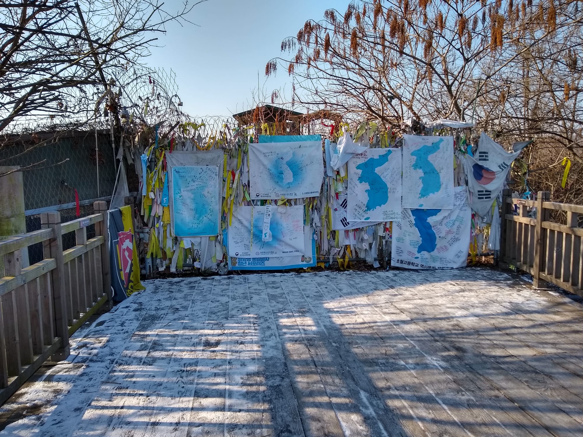
A wooden bridge deck ending at a fence hung with ribbons and painted cloth banners showing the Korean peninsula

Seoul & the Capital Area, South Korea

Paju

Ribbons and banners left by visitors at the Freedom Bridge at Imjingak in Paju. (Lance Vanlewen / Wikimedia Commons · CC BY-SA 4.0)

A city of about half a million people in the far north-west of Gyeonggi province, where the Imjin River meets the Han estuary and the Demilitarized Zone forms the northern boundary. Long a farming and garrison district, it now combines the Imjingak peace park and DMZ viewpoints with Paju Book City, the Heyri arts village and fast-growing commuter new towns.

Neighbourhoods

  • Munsan and the Imjingak area
    • DMZ visits
    • Close to public transport
    • Local life

    The northern town on the railway towards the border, a long-standing garrison and market centre with low streets of restaurants and shops. Imjingak park, the Unification Bridge road and the departure points for controlled tours of the border area lie a few kilometres beyond it.

    Open in Maps
  • Geumchon
    • Budget stays
    • Markets
    • Close to public transport

    The older commercial centre of the city, built around Geumchon station on the Gyeongui line, with traditional markets, cheap restaurants and motels. It is the most practical base for anyone arriving by train from Seoul.

    Open in Maps
  • Unjeong
    • Quiet and residential
    • Families
    • Shopping

    A new town of apartment towers, parks and shopping centres built from the 2000s in the south of the city, and now where most Paju residents live. It sits on the commuter line and the motorway towards Seoul.

    Open in Maps
  • Gyoha and Book City
    • Architecture
    • Bookshops and cafés
    • Quiet and residential

    The southern district by the Han estuary, holding the planned publishing town of low concrete and brick buildings designed by well-known architects, along with printing works, bookshops and cafés among reed beds.

    Open in Maps
  • Tanhyeon and the Heyri area
    • Arts and culture
    • Day trips
    • Cafés

    The north-western corner near the Imjin estuary, where the artists' village of Heyri, galleries, craft studios and a cluster of outlet shopping and themed cafés draw weekend visitors from Seoul.

    Open in Maps

Things to do

The border

  • Imjingakattraction

    A park and memorial complex beside the Imjin River, built in 1972 for families separated by the division of the peninsula, with an altar for ancestral rites, a steam locomotive damaged in the Korean War and the Freedom Bridge.

    Open in Maps
  • Third Tunnel of Aggressionattraction

    A tunnel running under the Demilitarized Zone, discovered in 1978 and dug by North Korea, part of which can be walked on controlled visits.

    Open in Maps
  • Dora Observatoryviewpoint

    A viewing platform on Dorasan hill looking north across the Demilitarized Zone into North Korea, with mounted binoculars and a briefing room.

    Open in Maps
  • Dorasan stationtransit hub

    The northernmost station on the South Korean railway towards Kaesong, opened in 2002 and signposted for a route that has never carried a regular passenger service.

    Open in Maps
  • Joint Security Arealandmark

    The compound just south of the former truce village of Panmunjom where the two sides meet face to face, visited only on organised tours that run when conditions allow.

    Open in Maps
  • Imjin Riverattraction

    The river that crosses the border and joins the Han estuary here, lined with wire, reed beds and wetlands that are important for wintering cranes and geese.

    Open in Maps

Books, art and design

  • Paju Book Cityattraction

    A planned town for the publishing industry, begun in the 1990s, where printers, publishers and bookshops occupy low buildings by well-known Korean and international architects.

    Open in Maps
  • Heyri Art Valleyneighborhood

    Korea's largest artists' village, begun in 1998 and home to the studios, galleries and museums of some 380 artists, writers and musicians, with a rule that no building rises above three storeys.

    Open in Maps

Countryside and walks

  • Gamaksantrail

    A 675-metre mountain on the eastern edge of the city, shared with Yangju and Yeoncheon, with ridge paths and views over the border country.

    Open in Maps
  • Odusan Unification Observatoryviewpoint

    A hilltop observatory where the Han and Imjin rivers meet, looking across the water towards the northern bank.

    Open in Maps
  • Jangneunglandmark

    The tomb of King Injo and his first queen, Inyeol, in wooded grounds outside the city centre, one of the Joseon royal tombs inscribed by UNESCO as a World Heritage Site.

    Open in Maps

Seasonal events

  • Ancestral rites at ImjingakSeollal in January or February, and Chuseok in September or October

    Families originally from the North gather at the Mangbaedan altar to bow towards their home towns on the two main holidays.

  • Paju Book Soriautumn

    A book festival held in Book City with readings, exhibitions, markets and events for children.

  • Heyri Pan Festivalspring and autumn

    The arts village holds seasonal weekends of open studios, concerts and outdoor performances.

  • Wintering cranes on the ImjinNovember to February

    Flocks of geese and cranes, including white-naped cranes, gather on the frozen paddies and riverbanks near the border each winter.

Eat and drink

Long-standing places and food districts in Paju. Hours, ratings and directions come from your maps app, always current.

Paju classics

  • Jangdan kong dishesrestaurant

    The Jangdan area near the border is known for its soybeans, served as thick biji stew of crushed beans, fresh tofu and soybean paste in the restaurants along the roads north.

    Open in Maps
  • Imjin River freshwater fishrestaurant

    Riverside restaurants serve maeuntang, a spicy freshwater fish stew, and fried or steamed river fish, with eel and shrimp in season.

    Open in Maps
  • Jangdan-kong makgeolli and tofurestaurant

    Handmade tofu, served warm with kimchi, and rice wine brewed locally are the standard country meal in the villages between the new towns.

    Open in Maps

Food districts and markets

  • Geumchon Marketmarket

    A traditional market in the old centre with produce, side dishes, noodle stalls and fried snacks, busiest on its regular market days.

    Open in Maps
  • Heyri cafésneighborhood

    The arts village is full of cafés and bakeries in concrete and timber buildings, many attached to galleries or small museums.

    Open in Maps
  • Book City cafésneighborhood

    Publishers' ground floors and converted printing halls hold coffee shops and bakeries used by editors, students and weekend visitors.

    Open in Maps

Experience Paju

History

Paju's low hills and river flats were farmed from early times, and the area's position on the road between Kaesong and Hanyang made it strategically important throughout the Joseon period. Several royal and aristocratic burials lie here, including the tomb of King Injo, and the district produced or sheltered notable Confucian scholars: Yi I, known as Yulgok, is commemorated at a shrine and academy in the city, and the Paju countryside was dotted with the estates of officials serving in the capital a short ride away.

War shaped the modern city. The Imjin valley was a corridor for invading armies for centuries, and in the Korean War the front line settled here, with heavy fighting along the river in 1950 and 1951 and again near the end of the conflict. The armistice of 1953 drew the Military Demarcation Line and the Demilitarized Zone across the north of the district, and the site of the former truce village of Panmunjom lies on the district's northern edge. Thousands of families who had left the North found themselves stopped here, which is why Imjingak was built in 1972 as a place for them to hold rites facing their home towns.

For decades afterwards Paju was a garrison district of army camps, curfews and farmland, with South Korean and American units stationed along the river. From the 1990s it changed quickly: Paju Book City was planned as a home for the publishing industry, the Heyri arts village was laid out beside it, Dorasan station opened in 2002 in the hope of trains running north, and large new towns at Unjeong and Gyoha turned the south of the city into a commuter suburb of Seoul. A large high-technology manufacturing complex became one of the city's biggest employers.

Culture & Customs

Paju's public culture is shaped by the border. Imjingak is a memorial rather than a viewpoint: separated families come at Seollal and Chuseok to bow towards the North at the Mangbaedan altar, and the fences around the park are thick with ribbons and messages left by visitors. Discussion of reunification, of the families divided in 1953 and of what the closed railway line might one day carry is part of ordinary conversation here in a way it is not further south, and it is a subject to be approached with tact.

Alongside that, the city has become one of the country's centres for books and the arts. Paju Book City gathers publishers, printers, designers and bookshops in a planned town whose architecture is studied in its own right, with reading halls, festivals and a strong culture of design; the Heyri village nearby was built by artists, writers and film people under rules about height and materials that give it a uniform, low-rise calm. Together they draw a steady weekend traffic of readers, students and day visitors from Seoul.

The rest of the city keeps its rural and military character: markets on fixed days, soybean and rice farming on the Jangdan plain, and a long-standing relationship between villages and the units stationed near them. Manners are those of the capital area — shoes off indoors, two hands for giving and receiving, no tipping — with the extra rule, at the border, that visitors do exactly what their guides say.

Daily Life

About 500,000 people live in Paju, and the number has roughly doubled since the 1990s as the new towns filled. Most residents are in apartment complexes at Unjeong and Gyoha in the south, within commuting distance of Seoul by motorway or the Gyeongui line; the northern half of the city is still farmland, low hills, small towns such as Munsan and large areas of military land where building is restricted.

Manufacturing is the backbone of the local economy: a large high-technology manufacturing complex employs many thousands of people directly and through its suppliers, alongside printing and publishing at Book City, furniture and paper works, and farming on the Imjin plain, where Jangdan soybeans and rice have a national reputation. Outlet shopping centres and the arts villages bring weekend visitors and seasonal work.

The rhythm is a commuter one in the south and a country one in the north, where field work, market days and the daily movement of military vehicles set the pace. Living so close to the border is routine rather than dramatic: sirens are tested, some roads have checkpoints, and the wire along the riverbank is simply part of the landscape. The city's running concerns are the cost and pace of new building, the state of the Imjin's wetlands, flooding in the monsoon, and how much the northern districts can develop while land-use restrictions remain.

Food

Paju's best-known produce comes from the Jangdan plain near the border, where the soil and the restricted land have kept farming small in scale. Jangdan soybeans are the basis of the local speciality, biji jjigae, a thick stew of crushed beans cooked with kimchi and pork, and of fresh tofu served warm in blocks with soy sauce and kimchi, and of doenjang bean paste sold in village shops. Jangdan also gives its name to a variety of hot pepper used in local chilli paste, and roadside restaurants north of Munsan make a point of the connection.

The Imjin River supplies the other local table. Freshwater fish are served as maeuntang, a peppery stew thickened with vegetables and crown daisy, and river eel and shrimp appear in season; in autumn the shrimp are salted for the year's kimchi. Duck, grilled or steamed with herbs, is a common country restaurant meal, as is bossam, boiled pork sliced and wrapped in leaves with radish salad.

Around the arts and publishing districts the food is more urban: cafés, bakeries and brunch restaurants in converted galleries and printing halls, along with pizza and pasta places aimed at weekend visitors. Geumchon's market supplies the everyday food — hand-cut kalguksu noodles, blood sausage, fried snacks and stalls of side dishes — and local makgeolli, the cloudy rice wine, is brewed from Paju rice and drunk with the bean and tofu dishes it suits best.

Planning tools

Budget

Paju is one of the cheaper parts of the capital area to eat and sleep in, and many people visit it as a day trip from Seoul rather than staying. Motels in Geumchon and Munsan are inexpensive, the hotels are in the new towns, and the main costs are an organised border tour and transport, since the sights are far apart.

Daily Budget Midrange
USD 110–200 (hotel in the new towns, restaurant meals, a guided border tour, taxis between sights)
Daily Budget Shoestring
USD 45–75 (motel or guesthouse, market food, trains and local buses)

Book a border tour several days ahead and bring a passport; an all-day taxi or a hire car is often the only practical way to link Imjingak, Book City and Heyri.

Best Time to Visit

Late April to June and September to early November, when the weather is mild and the riverside is at its best. Winter is cold and exposed, though the border landscape is stark and the wintering cranes arrive on the Imjin wetlands. July brings monsoon rain, and the Imjin can flood; August is hot and humid.

Suggested Number of Days

Most visits last a single day, often on an organised tour from Seoul. Anyone who wants the arts and publishing districts as well as the border area, or the hills and the river, should allow two.

First Visit
1 day
With Surroundings
2 days

Transportation

The Gyeongui–Jungang railway runs from Seoul through Geumchon to Munsan, with a shuttle service continuing to Imjingang station for the border area. City buses link the stations with the new towns, Book City and Heyri, but they are infrequent between districts and journeys can be slow. Many visitors come on a coach tour or by car along the motorway that follows the Han estuary.

Sights are spread over a wide rural area — allow far more time between them than the map distances suggest, and check the last buses back.

Airport & Station Connections

Trains from central Seoul reach Geumchon in a little over an hour and Munsan shortly after, with a connecting shuttle to the border park. Express buses and the Jayu-ro motorway along the Han estuary take about an hour by road from Seoul. Incheon International Airport is around 70 kilometres to the south-west, with limousine buses to the new towns.

Walkability

Individual districts are walkable but the city is not. Book City's blocks, the Heyri village and the Imjingak park each take an hour or two on foot, and the old centres of Geumchon and Munsan are compact. Between them lie kilometres of farmland, motorway and military land, so transport is needed for every move. Paths at the border sights are flat and mostly paved.

Safety

Paju is a safe city with very low crime, but it sits on the northern edge of the capital area. Access to the DMZ is controlled, and tours are occasionally cancelled when military tension rises. Military installations, checkpoints and restricted zones are common in the north of the city, some riverbanks are fenced and mined, and the Imjin floods in the summer monsoon.

Follow guides' rules exactly at the DMZ, carry a passport on those tours, obey all signs and fences near the river and military areas, and never photograph checkpoints or soldiers. Check current official travel advice before travelling.

Climate

A continental climate slightly colder than Seoul's, with the open river valley exposed to winter winds from the north. Summers are hot and humid with the bulk of the year's rain in July, and spring and autumn are short, dry and clear.

Summer
hot and humid, commonly 29–32°C by day in July and August, with heavy monsoon rain and river flooding
Winter
cold and dry, with January days near −2°C and nights often below −10°C, and the Imjin freezing along its edges

Local Customs

Customs are those of the capital area — no tipping, shoes off indoors, two hands for giving and pouring. The division of the peninsula is a matter of family history for many residents, including descendants of people who left the North before 1953, and is spoken about with care rather than curiosity.

Photography is restricted at and around the border sights, and staff will say where it is allowed; follow those instructions exactly.

Common Payment Methods

The currency is the South Korean won. Cards and mobile payment work in shops, cafés and restaurants and on buses and taxis, but small country restaurants and market stalls may want cash, and ATMs are fewer outside the new towns and station areas.