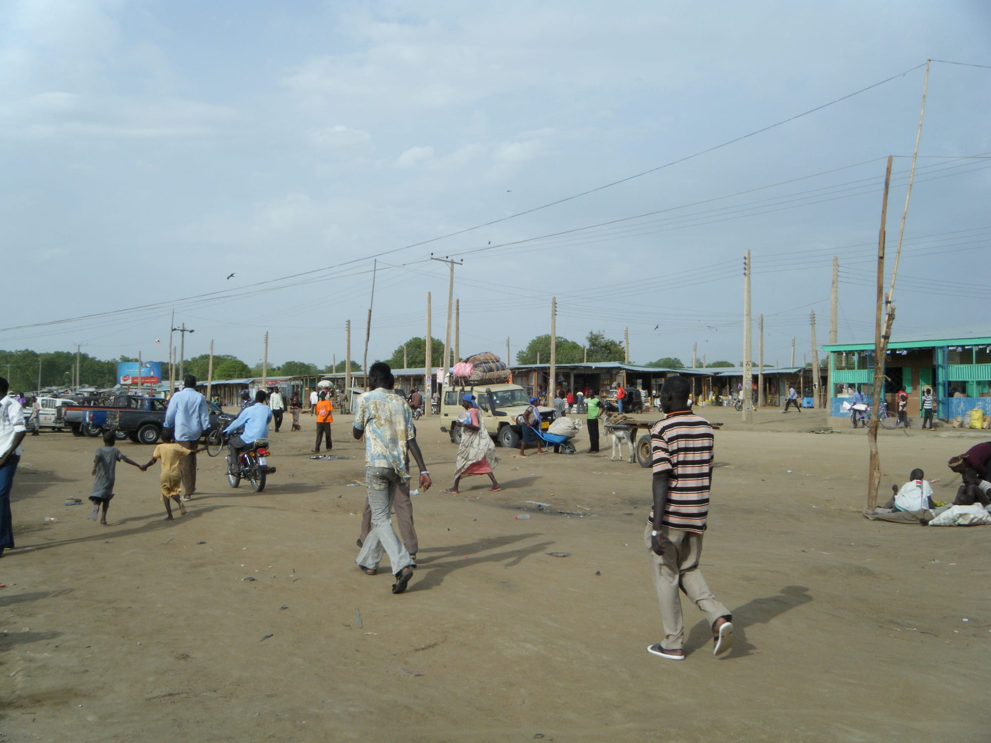
A wide sandy open space at the edge of a market in Bor, with low stalls, a painted shopfront, power poles and people walking

Malakal & the Upper Nile, South Sudan

Bor

The edge of Merol market in Bor, with newly raised power lines above the sandy ground. (Mr leroy playpus (Tuttle) / Wikimedia Commons · CC BY-SA 4.0)

A town on the east bank of the White Nile at the southern edge of the Sudd wetlands, capital of Jonglei state and the home of the Dinka Bor. It lies at the end of the paved road from Juba, and its recent history has been shaped by war and by years of severe flooding. This page is written to explain the town, not to encourage travel.

Neighbourhoods

  • Bor town centre
    • First-time visitors
    • Markets
    • Local life

    The area around the main market and the state government offices, with shops, small guesthouses, churches and the bus and lorry stands at the end of the road from Juba. Almost everything official in Jonglei happens here.

    Open in Maps
  • The riverside and port
    • River views
    • Trade

    The bank of the White Nile west of the centre, where barges and canoes land, fishermen work and cattle are watered. Beyond it the channels and papyrus of the Sudd begin.

    Open in Maps
  • The airstrip and compound area
    • Transport connections
    • Aid compounds

    Fenced compounds of aid organisations and the United Nations around the airstrip, with warehousing and vehicle yards. It is the arrival point for outsiders and the base for operations across Jonglei.

    Open in Maps
  • The outer neighbourhoods
    • Quiet and residential
    • Local life

    Spread-out districts of thatched and tin-roofed houses on the flat ground around the centre, where most people live. Several were flooded for long periods in recent years and many households have had to rebuild on raised ground.

    Open in Maps

Things to do

The river and the wetlands

  • The White Nile riverbankattraction

    The riverside west of the town, where canoes and barges land, cattle are watered and the channels of the wetland begin; hippos and crocodiles are present.

    Open in Maps
  • The edge of the Suddattraction

    The papyrus swamps, lagoons and floating vegetation that spread north from the town across the plains, one of the largest wetlands in the world and rich in birdlife.

    Open in Maps

The town

  • Bor marketmarket

    The town's main market, selling sorghum, fresh and dried fish from the river, milk, vegetables and goods brought up the paved road from Juba.

    Open in Maps
  • Bor Airporttransit hub

    The airfield serving the town and the only airport in Jonglei, used by humanitarian and charter flights and by small aircraft reaching the rest of the state.

    Open in Maps
  • The cattle camps outside the townattraction

    Dry-season camps of long-horned cattle on the higher ground and river margins, central to Dinka Bor life, and private places rather than sights to be visited casually.

    Open in Maps

Seasonal events

  • Christmas and EasterDecember and March or April

    The principal church festivals, when choirs sing in Dinka and families gather from the surrounding countryside.

  • Independence Day9 July

    The anniversary of independence from Sudan in 2011, marked with official parades and gatherings in the town.

  • Dry-season dances and wrestlingDecember to March

    Wrestling matches and night dances between sections and villages, held once the herds have gathered near water and roads are open.

Eat and drink

Long-standing places and food districts in Bor. Hours, ratings and directions come from your maps app, always current.

Bor staples

  • Nile fishrestaurant

    Tilapia, Nile perch and catfish from the river and the wetland, grilled over charcoal, stewed, or split and sun-dried for the market.

    Open in Maps
  • Kisra and stew kitchensrestaurant

    Small eating houses serving kisra, the thin fermented sorghum flatbread, or stiff porridge with okra, bean or groundnut stew.

    Open in Maps

Market and street food

  • Bor marketmarket

    Sorghum, dried fish, milk, groundnuts and imported rice, sugar and oil trucked up the road from Juba.

    Open in Maps
  • Charcoal grills and tea stallscafe

    Goat and beef grilled at roadside stands in the evening, and sweet black or milky tea sold from charcoal stoves through the day.

    Open in Maps

Experience Bor

History

Bor is the home of the Dinka Bor, cattle keepers and fishermen of the eastern bank of the White Nile at the southern edge of the Sudd, whose life moves between settlements on higher ground and camps near the water. The river made the place: it was a landing point on the route between Juba and the north long before it was a town, and the first modern Christian mission in what is now South Sudan was founded at Malek, 19 kilometres south, in the first decade of the twentieth century, making the area a centre of Anglican church life.

Two events fixed Bor in the country's history. In May 1983 a mutiny by southern soldiers of the Sudanese army garrison here is usually taken as the beginning of the second civil war, out of which the Sudan People's Liberation Movement/Army emerged under John Garang, a Dinka born at Wangulei in Twic East, north of the town. Work on the Jonglei Canal, meant to carry the Nile around the Sudd, was halted in 1984. Then in 1991, after a split in the southern movement, large numbers of Dinka civilians were killed in the Bor area, a wound that still shapes politics.

Bor, an administrative centre since Anglo-Egyptian days and the seat of government in Jonglei, grew after 2005 with returning families, aid operations and the paved road from Juba. Fighting reached the town again after December 2013, when it changed hands several times and much of it was damaged, and thousands sheltered in the United Nations site. Since then the dominant story has been water: the exceptional flooding of the early 2020s inundated large parts of the area, drowning fields and cattle and displacing many households.

Culture & Customs

Dinka Bor culture rests on cattle. A family's herd is its wealth and its history, bride-wealth is counted in cows, young men take praise names from the colour and horns of a favourite ox and compose songs about it, and disputes are settled by chiefs and customary courts with cattle as compensation. In the dry season young people move with the herds to camps near the river, where the animals are tethered at night among fires of burning dung.

Fishing is unusually important here compared with drier Dinka areas, because the Sudd and the river are at the door, and spear fishing and canoe work are skills learned young. Age-sets, initiation and the authority of elders structure society, and dances and wrestling matches between sections are the main public events of the dry season.

The Anglican church has deep roots in Bor, with hymns and services in Dinka, and church networks organise schools, clinics and much community life; Catholic and other congregations are present too. The town has produced a striking number of national political and military figures, and its people are conscious of that history. The killings of 1991, the fighting of 2013 and the years of flooding are all discussed, but carefully, and visitors do well to listen rather than take positions.

Daily Life

A United Nations estimate put Bor's population at about 728,000 people in 2024, and the figures have moved sharply with fighting and flooding. The town is low and spread out, with tin roofs and mud brick near the centre and round thatched houses and cattle byres beyond, and raised ground has become valuable since the floods.

Cattle, fishing and sorghum farming support most households, alongside state government work, trade and employment with aid organisations. The paved road from Juba makes Bor better supplied than other towns in the region, and lorries bring rice, sugar, oil and fuel; prices still rise quickly when the road is insecure. Many families have depended on food assistance through the flood years.

Days begin early with milking, fishing and the market, and slow through the afternoon heat. Water comes from the river and boreholes, power from generators and solar panels, and mobile coverage is better in the town than outside it. Flooding, cattle raiding and violence elsewhere in Jonglei, and the cost of food and fuel are the constant subjects of local life, and many households still live away from land they once farmed.

Food

Fish and milk dominate the everyday diet. The Nile and the swamps yield tilapia, Nile perch and catfish, eaten fresh and grilled over charcoal, stewed, or split and sun-dried for storage and trade, and dried fish stewed with okra or groundnut paste is a common meal. Milk, fresh or soured, comes from the herds and is the prized food of the cattle camps.

Sorghum is the staple grain, ground and cooked into a stiff porridge or fermented and baked as kisra, the thin sour flatbread, and eaten with stews of okra, often dried and pounded, beans, leafy greens or groundnut paste. Maize is grown as well, and wild foods from the wetland, including water-lily roots and seeds, become important in hungry seasons and after floods.

Meat is food for occasions: an ox is slaughtered and shared at a wedding, a funeral or a settlement between families, while goat is eaten more freely. Market food reflects the road from Juba, with rice, wheat flour, sugar and cooking oil, and ful, stewed brown beans, and bread are sold at stalls. Sweet black tea and milky tea are drunk through the day, and sorghum beer is brewed at home for gatherings.

Planning tools

Budget

There is no tourist economy. Accommodation is limited to aid compounds and a few basic guesthouses charged in dollars or pounds, and food and fuel arrive by road from Juba or by air, which keeps prices high. Vehicle hire and flights, rather than rooms and meals, decide what a stay costs.

Daily Budget Midrange
USD 150–300 (a compound room, meals and a vehicle with driver, before flights and security costs)
Daily Budget Shoestring
USD 50–100 (a basic guesthouse room, market meals, shared transport from Juba) — independent budget travel is not realistic

Carry US dollars in cash, arrange rooms and transport through a host organisation, and expect prices to follow the exchange rate.

Best Time to Visit

The dry season from December to March is when the roads and tracks around the town are passable and floodwater is at its lowest, and when herds gather near the river. The rains from May to October raise the Nile and flood the surrounding plains. Security conditions and flooding, rather than the calendar, decide whether travel is possible.

Suggested Number of Days

A day or two covers the town, the market and the riverbank. Longer stays are about the river and the wetland country around it, and depend on having a vehicle or a boat and local permission rather than on distance.

First Visit
1–2 days
With Surroundings
2–4 days

Transportation

Motorcycle taxis and shared pick-ups serve the town, while organisations working here run four-wheel drive vehicles. The paved road from Juba reaches Bor and buses use it, but roads further into Jonglei are dirt tracks cut by floods for much of the year, and canoes and small boats remain the everyday transport in the wetlands.

Road journeys are made in daylight and with current security advice, and river travel is slow and depends on water levels.

Airport & Station Connections

Bor lies about 190 kilometres north of Juba by road, at the end of the paved road, usually three to five hours by bus or car depending on checkpoints and the state of the surface. Bor Airport takes humanitarian and charter flights from Juba, a short hop by small aircraft, and barges on the White Nile connect the town with Juba and Malakal, slowly and irregularly.

Walkability

The centre is flat, sandy and small enough to cross on foot in twenty or thirty minutes, taking in the market, the offices and the churches. There are no pavements, the heat in the middle of the day is heavy, and the riverbank should not be approached casually on foot because of hippos and crocodiles.

Safety

Bor saw some of the heaviest fighting of the civil war after December 2013, changing hands several times, and thousands of people sheltered in the United Nations site beside the town. Jonglei continues to see armed youth groups, cattle raiding, abductions and revenge attacks, and flooding, disease and food shortages compound the risks. Medical care is very limited.

Most governments advise against all travel. Anyone present for work should follow strict organisational security rules and keep evacuation cover. Check current official travel advice before travelling.

Climate

Hot all year, with a rainy season from about May to October and a dry season from November to April. The flat clay plains drain poorly, and in recent years exceptional floods have left large areas around the town under water for long periods.

Summer
rainy season, roughly May to October: humid, about 24–34°C, with storms, high river levels and flooding
Winter
dry season, November to April: hot and dusty, often 35–38°C by afternoon in March, with cooler nights in December

Local Customs

This is the country of the Dinka Bor, and Dinka is the language of the town alongside Juba Arabic and English. Cattle are the measure of wealth, marriage and standing, and are spoken of with respect. Churches are central to public life, Sunday is quiet, and elders are greeted first. The town's history of war and displacement makes the events of 1991 and 2013 sensitive subjects.

Ask before photographing anyone, especially in cattle camps, which are private; never photograph soldiers, police, the airport or United Nations sites; and avoid taking sides in discussions of local politics.

Common Payment Methods

The South Sudanese pound is the currency, but US dollars are used for rooms, vehicles and anything substantial and are changed through trusted contacts. Cash is the only workable means of payment, cards are not accepted and ATMs cannot be relied on. Clean, recent dollar notes are preferred.