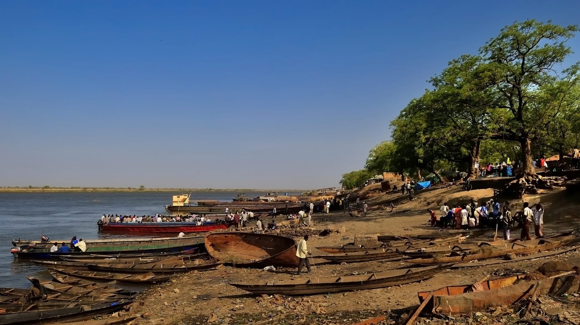
Wooden boats pulled up on a sandy riverbank under shade trees, with passenger boats on the wide Nile beyond

South Sudan

Malakal & the Upper Nile

The riverbank at Malakal on the White Nile, the capital of Upper Nile state. (Michael Walsh / Wikimedia Commons · CC BY 3.0)

The north-east of South Sudan, made up of Upper Nile, Unity and Jonglei, where the White Nile spreads into the Sudd wetland and flat floodplains run east to the Ethiopian border — the home of the Nuer, Shilluk and many Dinka, the country's oilfields and a vast antelope migration. This page is written to explain the region, not to encourage travel.

Explore Malakal & the Upper Nile

History

The Upper Nile has long been the land of three Nilotic peoples: the Shilluk, or Chollo, along the west bank of the White Nile; the Nuer, across the floodplains of Unity, northern Jonglei and eastern Upper Nile; and the Dinka, from Bor in the south to the Padang communities in the north. Further east live the Murle around Pibor, the Anyuak near the Ethiopian border and the Maban. The Shilluk formed a kingdom under a divine king, the reth, whose seat at Fashoda, now Kodok, lies north of Malakal.

In the 19th century Egyptian and northern traders pushed up the Nile, and in 1898 a small French expedition under Jean-Baptiste Marchand reached Fashoda just ahead of Kitchener's British-Egyptian force, a standoff that ended with French withdrawal. Under Anglo-Egyptian rule Malakal became the provincial capital, while the Nuer resisted British control into the 1920s.

The region was central to both civil wars. Work on the Jonglei Canal, meant to carry the Nile around the Sudd, stopped in 1984 after rebel attacks, and the 1991 split in the southern movement led to the killing of many Dinka civilians in Bor. Oil production in Unity and Upper Nile began in the late 1990s. After December 2013, Bor, Malakal and Bentiu saw some of the heaviest fighting of the civil war, and tens of thousands sheltered in UN protection sites. The 2018 peace deal reduced the fighting, but clashes in Upper Nile in early 2025 were followed by the arrest of Riek Machar, and tension remains high.

Culture & Customs

Cattle define Nuer and Dinka life here as elsewhere in South Sudan, but the rhythm is shaped by water: herds move to the edges of the Sudd and the rivers in the dry season and back to higher ground in the rains. Among the Nuer, bride-wealth in cattle, age-sets and the facial scarification of young men, once near-universal, carried great meaning, though the practice is now declining. Songs praising oxen and composed by young men are an art form.

The Shilluk keep their monarchy: the reth is installed at Fashoda in elaborate ceremonies and remains a unifying figure for the community. The Murle, Anyuak and other peoples of the east have their own languages and traditions, and relations between communities are strained by cattle raiding and child abductions that have taken many lives.

Christianity, spread by Presbyterian and Catholic missions, is widespread, and hymns in Nuer, Dinka and Shilluk are sung in churches of mud and thatch. Prophets, such as the 19th-century Nuer figure Ngundeng Bong, still hold a strong place in local memory.

Daily Life

Malakal, Bentiu and Bor are the largest towns, each with tens of thousands of people, though their populations have risen and fallen with fighting and displacement. Much of the population has lived in or around UN protection sites and displacement camps for years, and Maban county hosts large refugee camps for people who fled Sudan's Blue Nile state.

Oil from the fields of Unity and Upper Nile is exported by pipeline through Sudan and provides most of the country's government revenue, but little reaches local communities, and oil-related pollution is a concern. Most people live by herding, fishing and small-scale sorghum farming, heavily supported by food aid.

Water governs daily life. In recent years floods have drowned villages, fields and cattle across Unity and Jonglei, and many families move by canoe. The day begins early with milking or fishing, markets open before the heat, and evenings bring families together around fires to keep the insects away.

Food

Fish and milk are central here. The Nile, the Sobat and the channels of the Sudd provide Nile perch, tilapia and catfish, eaten fresh, grilled or stewed, or split and sun-dried for storage and trade; dried fish from the region is sold in markets far to the south. Milk, fresh or soured, is the prized food of the cattle camps.

Sorghum is the staple grain, cooked into a stiff porridge or kisra, a thin fermented flatbread, and eaten with okra, bean or groundnut stews. In hungry seasons and during floods, wild foods such as water-lily roots and seeds from the swamps become important.

Meat is eaten at weddings, funerals and ceremonies, when a bull is slaughtered and shared. In Malakal's market, influences from Sudan are strong: ful, stewed beans, and bread, lentils, grilled meat and sweet tea with milk are standard. Sorghum beer is brewed for gatherings in rural areas.

Attractions & Natural Wonders

Malakal, on the White Nile just below its meeting with the Sobat, is the region's historic river port, with boats drawn up along its sandy waterfront. North along the river is Kodok, the old Fashoda, seat of the Shilluk king and scene of the 1898 standoff.

Bentiu, the capital of Unity, lies on the plains north of the Sudd among oil installations and floodwater, and has little of the old town left after war and floods.

The Sudd is the region's great natural feature: where the White Nile and the Bahr el Zeraf spread across the plains, papyrus swamps, open lagoons and floating islands cover an area that swells and shrinks with the seasons. It supports shoebills, huge colonies of waterbirds, hippos, crocodiles and the Nile lechwe, an antelope found only in South Sudan and Ethiopia.

In the far east, in the Greater Pibor Administrative Area, carved out of Jonglei in 2014 and again in 2020, the Boma plateau rises near the Ethiopian border. Boma National Park and the plains to its west are the stage for one of the largest land-mammal migrations on Earth, as white-eared kob, tiang and Mongalla gazelle move between Boma and Badingilo with the rains, a spectacle surveyed from the air but almost never seen from the ground.

Cities in Malakal & the Upper Nile

Planning basics

Budget

There is no tourist economy. The only accommodation in Malakal, Bentiu or Bor is in aid compounds, UN bases and a handful of basic guesthouses, and access is by humanitarian or charter flight from Juba. Costs are higher than elsewhere in the country, because almost everything arrives by air or river barge.

Daily Budget Midrange
USD 150–300 for a compound room, meals and a vehicle, before flights and security
Daily Budget Shoestring
Not realistic — there is no independent travel here

Everything is paid in US dollars or pounds in cash and arranged through a host organisation, often weeks ahead.

Safety

This is one of the most conflict-affected parts of the country. The region's main towns changed hands several times in 2013 and 2014, fighting resumed in Upper Nile in 2025, and armed youth groups, intercommunal raids, abductions and revenge attacks recur, especially in Jonglei. Flooding, disease and food shortages compound the risks, and health care is very limited.

Most governments advise against all travel. Anyone present for work should follow strict organisational security rules and keep evacuation cover. Check current official travel advice before travelling.

Climate

Hotter and drier than the south of the country, with a single rainy season from about May to October and a long, hot dry season when afternoons in Malakal often pass 38°C. The flat clay plains drain poorly, and in recent years exceptional floods have left large parts of Unity and Jonglei under water for long periods.

Summer
rainy season, roughly May to October: humid, 25–35°C, with widespread flooding
Winter
dry season, November to April: very hot by March and April, dusty harmattan-like winds

Transportation

Malakal, Bentiu, Bor and several smaller towns have airstrips used by UN and humanitarian flights. The paved road from Juba reaches Bor, but elsewhere roads are dirt tracks cut by floods for much of the year. The White Nile carries slow barges and boats between Juba, Bor and Malakal, and canoes remain the everyday transport in the swamps.

Fly rather than travel by road or river, and move only with current security advice and a host organisation.

Best Time to Visit

The dry season from December to March is when roads are passable, the Sudd's edges shrink and the antelope move across the plains between Boma and Badingilo. In practice security and flooding, not the season, decide whether anyone can travel here.