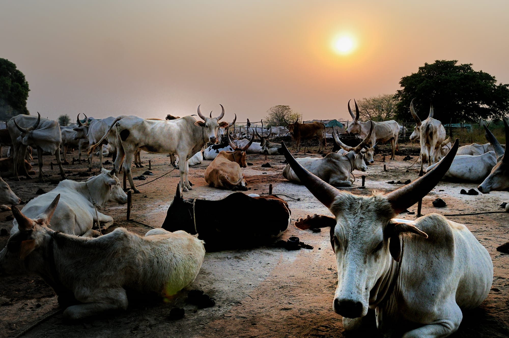
Long-horned white and brown cattle resting on bare ground in a cattle camp at sunset, with trees behind

South Sudan

Wau & Bahr el Ghazal

Dinka cattle in a camp at Wau, the capital of Western Bahr el Ghazal. (Michael Walsh / Wikimedia Commons · CC BY 3.0)

The north-western quarter of South Sudan, a land of savanna, seasonal rivers and floodplain running from the Sudanese border down to the edge of Equatoria, made up of Northern and Western Bahr el Ghazal, Warrap and Lakes, and dominated by Dinka cattle-keeping culture. This page is written to explain the region, not to encourage travel.

Explore Wau & Bahr el Ghazal

History

Bahr el Ghazal, the "river of gazelles", takes its name from the river that gathers the region's streams before they join the White Nile. It has long been home to the Dinka, who make up most of its people, along with the Luo (Jur), the Bongo and the many smaller groups of the Wau area collectively called the Fertit. In the mid-19th century it became the hunting ground of traders from the north, who built fortified stations, or zaribas, and seized ivory and people; the most powerful of them, al-Zubayr Rahma Mansur, ruled a private empire here until Egypt recognised him as its governor in 1873.

The Mahdist state took the area in the 1880s, and after 1898 it came under Anglo-Egyptian rule, with Catholic missions bringing schools and churches. The Babanusa–Wau railway reached Wau in the early 1960s. In the long second civil war the region suffered raids by government-backed militias from the north and a devastating famine in 1998.

Since independence, the 2013 war and later clashes brought fighting to Wau in 2016 and displaced tens of thousands into church and UN sites. President Salva Kiir comes from Warrap, and politics in the region is closely tied to Juba. To the north lies Abyei, an area claimed by both South Sudan and Sudan whose final status remains unresolved.

Culture & Customs

The Dinka, or Jieng, shape the culture of most of the region, and cattle are its centre. A family's herd carries its wealth and history; marriages are sealed with bride-wealth counted in cows, young men take names from their favourite oxen, and songs and poems praise the animals' colour and horns. In the dry season young people move with the herds to cattle camps near the rivers, where the cows are tethered at night among smoking dung fires.

Initiation, age-sets and the authority of chiefs and spear-masters remain important in rural life, and customary courts settle many disputes over cattle, marriage and compensation. Dances and songs accompany weddings.

Wau is more mixed: Luo, Fertit and Dinka live alongside each other, and the town has a long Catholic history, with its cathedral at the centre of community life. Christianity is widespread across the region, often alongside traditional belief, and Arabic closer to Sudanese Arabic than to Juba Arabic serves as the common language of Wau's markets.

Daily Life

Wau is the region's largest town and one of the biggest in the country, with a population in the low hundreds of thousands. Aweil, Kuajok, Tonj, Rumbek and Yirol are smaller market and administrative towns, and most people live in scattered homesteads of round, thatched huts across the plains.

Life follows the seasons. In the rains families plant sorghum, groundnuts and sesame near their homesteads and the herds graze the higher ground; in the dry season herders move to the river pastures. Trade runs along the roads to Juba and, when the border is open, north into Sudan, and markets sell goods brought in by lorry. Many households depend on food aid at times, and flooding and drought in successive years have damaged harvests.

Days begin early, with milking and tea; the heat of the afternoon slows everything, and the evening is spent around the fire in the homestead or the cattle camp. Schooling has expanded since 2005 but is still limited, and intercommunal violence over cattle and grazing land remains the most pressing local problem.

Food

The diet rests on sorghum and milk. Sorghum is ground and cooked into a stiff porridge, or made into kisra, a thin fermented flatbread, and eaten with stews of okra, beans, groundnut paste, leafy greens or dried fish. Milk, fresh or soured, is the most prized food in the cattle camps, where young herders may live largely on it in the dry season.

Meat is eaten mainly at ceremonies, weddings and funerals, when an animal is slaughtered and shared, since cattle are too valuable to kill casually. Fish from the Jur, Lol and other rivers and from the swamps of Lakes state is eaten fresh or sun-dried, and groundnuts, sesame and wild fruits add variety in season.

In Wau and the other towns, market stalls sell ful, stewed beans, with bread, grilled meat, lentils and rice brought in by road, and sweet tea is drunk at roadside tea stalls throughout the day. Local beer brewed from sorghum is common at gatherings.

Attractions & Natural Wonders

Wau, on the Jur River, is the region's main town and its most interesting: a riverside settlement of markets, older colonial-era buildings and the Catholic Cathedral of St Mary. Its mixed population of Luo, Fertit and Dinka gives it a character distinct from the cattle towns to the east.

Aweil, the capital of Northern Bahr el Ghazal, sits on the railway line from Sudan amid flat farmland dotted with thatched homesteads, and the Lol River flows nearby. Rumbek, the capital of Lakes state, is a small town of markets and schools at the heart of Dinka cattle country, and the lakes and swamps that give the state its name lie to its east and north, towards the Sudd.

The Southern National Park covers a great tract of savanna and woodland in the south of the region, crossed by rivers that flow north towards the Nile. It was once known for buffalo, giraffe and many kinds of antelope; decades of war and poaching have reduced them, and the park is almost never visited.

Across the whole region, the dry-season cattle camps are the most striking sight — thousands of long-horned cattle tethered at dusk among the smoke of dung fires.

Cities in Wau & Bahr el Ghazal

Planning basics

Budget

There is no tourist economy at all. Wau, Aweil, Kuajok and Rumbek have a few basic guesthouses and compounds used by aid workers and traders, priced in US dollars and well above what their standard would suggest. Getting there usually means a humanitarian or charter flight from Juba, which dwarfs any other cost.

Daily Budget Midrange
USD 100–250 for a basic compound room, meals and a vehicle, before flights and security
Daily Budget Shoestring
Not realistic — visitors are almost all aid workers, officials or traders with hosts

Everything is paid in US dollars or pounds in cash, and accommodation and transport should be arranged through a host organisation.

Safety

The region has seen fighting between government forces and opposition groups, notably around Wau in 2016, and intercommunal violence and cattle raiding cause heavy loss of life, especially in Lakes and Warrap. Revenge killings, armed youth, roadblocks, banditry and flooding all affect movement, and health care outside the towns is minimal.

Most governments advise against all travel. Anyone present for work should follow their organisation's security rules, avoid road travel at night and keep evacuation cover. Check current official travel advice before travelling.

Climate

Tropical savanna, drier and more strongly seasonal than Equatoria. Rain falls roughly from April or May to October, and the flat north around Aweil and Warrap floods widely in the wettest months. The dry season is hot and dusty, with afternoons often near 38°C by March and April.

Summer
rainy season, roughly May to October: warm and humid, with floods on the northern plains
Winter
dry season, November to April: hot and dusty, cooler nights in December and January

Transportation

Wau, Aweil, Kuajok and Rumbek have airstrips served by humanitarian and charter flights from Juba. Roads are mostly unpaved, often impassable in the rains, and marked by checkpoints and occasional ambushes. The old railway from Sudan through Aweil to Wau has seen little regular use for years.

Fly between towns where possible, and travel by road only with current security advice and a local host.

Best Time to Visit

The dry season from December to March is the only time roads between the towns are reliably passable, and when herds gather in the cattle camps near rivers. Security and permits, not the season, decide whether any travel is possible.