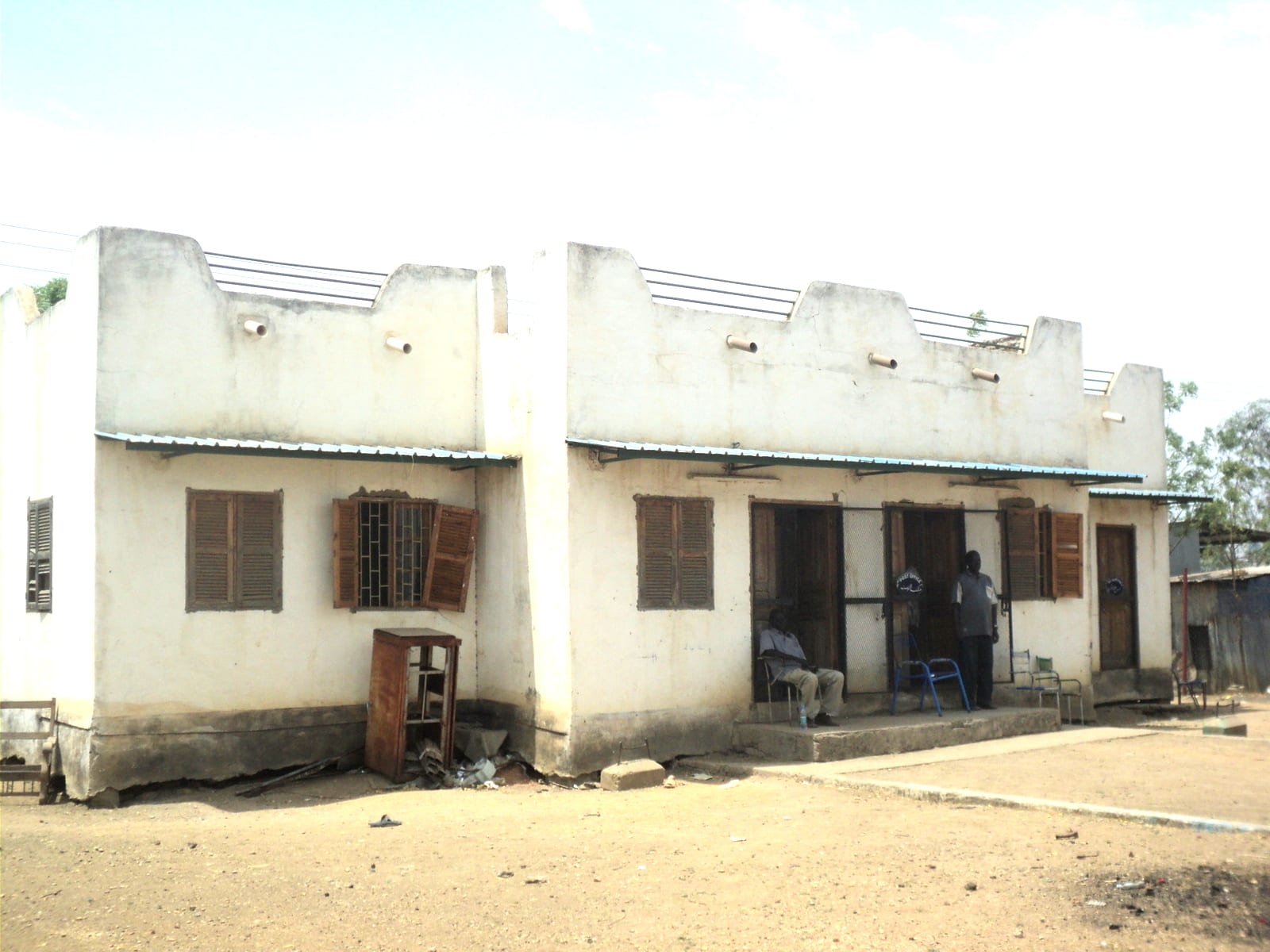
A low whitewashed colonial-era building with shuttered windows and a stepped parapet on bare sandy ground in Malakal

Malakal & the Upper Nile, South Sudan

Malakal

The old post office in Malakal, one of the town's surviving administrative buildings. (Leovdvxxx / Wikimedia Commons · CC BY-SA 4.0)

A river port on the White Nile in the far north-east of South Sudan, capital of Upper Nile state and for a century the administrative centre of the region. It stands just below the meeting of the Nile and the Sobat, in Shilluk country, and has been shaped by war, displacement and river trade. This page is written to explain the city, not to encourage travel.

Neighbourhoods

  • The river front and port
    • River views
    • Trade
    • Local life

    The sandy bank where barges, cargo boats and canoes tie up, with boatyards, fuel drums and traders unloading goods brought upstream and down. It is the reason the town exists and still its busiest edge.

    Open in Maps
  • The old administrative centre
    • Historic district
    • First-time visitors

    The grid of streets laid out under Anglo-Egyptian rule behind the river, holding state government offices, older public buildings, the market and what remains of the town's colonial-era architecture after years of fighting.

    Open in Maps
  • The market quarter
    • Markets
    • Street food

    The dense blocks of stalls, small shops and eating places inland from the river, where dried fish, sorghum, imported goods and cloth change hands and where most of the town's day-to-day trade happens.

    Open in Maps
  • The airport and compound side
    • Transport connections
    • Aid compounds

    The area around the airstrip north of the centre, with United Nations and aid organisation compounds, warehousing and the displacement sites that have housed tens of thousands of people for years.

    Open in Maps
  • The outer residential areas
    • Quiet and residential
    • Local life

    Spread-out districts of mud brick, tin and thatch at the edge of the town, rebuilt repeatedly after fighting and flooding, where most residents live and where services are thinnest.

    Open in Maps

Things to do

The river and the town

  • The White Nile waterfrontattraction

    The sandy riverbank and port where barges and canoes land, the historic point of arrival for everyone coming upriver from Sudan or downstream from Juba.

    Open in Maps
  • Malakal marketmarket

    The town's main market, trading sorghum, dried and fresh fish from the Nile and the Sobat, milk, cloth and imported goods that arrive by air, river or road.

    Open in Maps
  • The old administrative quarterneighborhood

    The streets of government buildings and colonial-era offices laid out when Malakal was the provincial capital of the Upper Nile.

    Open in Maps

Getting around

  • Malakal Airporttransit hub

    The airfield north of the town, used by United Nations and humanitarian flights and the practical way in and out for outsiders.

    Open in Maps

Short trips from the city

  • Kodokattraction

    The old Fashoda, the seat of the Shilluk king, where the meeting of French and British-Egyptian forces in 1898 became a crisis between the two powers.

    Open in Maps

Seasonal events

  • Christmas and EasterDecember and March or April

    The main church festivals of the year, with services and hymns sung in Shilluk, Nuer and Dinka as well as English and Arabic.

  • Independence Day9 July

    The anniversary of independence from Sudan in 2011, marked with official gatherings in the town.

  • Eid al-Fitrvaries with the lunar calendar

    Marked by the town's Muslim community, whose presence dates from its long trading links with Sudan to the north.

Eat and drink

Long-standing places and food districts in Malakal. Hours, ratings and directions come from your maps app, always current.

Malakal staples

  • Nile and Sobat fishrestaurant

    Nile perch, tilapia and catfish grilled over charcoal or stewed, and the sun-dried fish for which the Upper Nile is known across the country.

    Open in Maps
  • Kisra and stew kitchensrestaurant

    Small eating houses serving kisra, the thin fermented sorghum flatbread, with okra, bean or groundnut stews.

    Open in Maps

Market and street food

  • Malakal marketmarket

    Sorghum, dried fish, milk, groundnuts and imported rice, sugar, oil and lentils, with prices that rise sharply when the river and air routes are interrupted.

    Open in Maps
  • Ful and bread stallsrestaurant

    Stewed brown beans with oil and bread, the standard cheap breakfast here as in Sudan to the north.

    Open in Maps
  • Tea stallscafe

    Sweet black tea and milky tea with spices, sold from charcoal stoves under trees through the working day.

    Open in Maps

Experience Malakal

History

Malakal grew where the White Nile bends below its junction with the Sobat, in the land of the Shilluk, whose kingdom under a divine king, the reth, has its historic seat at Fashoda, now Kodok, downstream on the west bank. The river here was the highway between the Sudanese north and the southern plains, and nineteenth-century traders, soldiers and missionaries all came this way. In 1898 a small French expedition reached Fashoda just ahead of a British-Egyptian force, a standoff that brought the two powers close to war and ended with the French withdrawal.

Under Anglo-Egyptian rule the administration built its provincial headquarters at Malakal rather than at the royal seat, and the town acquired a grid of streets, government offices, a port and mission schools, becoming the administrative and trading centre of the Upper Nile. Steamers linked it to Khartoum and to Juba, and its market drew fish, grain and cattle from a wide area.

Both civil wars reached the town, but the destruction that shaped the Malakal of today came after December 2013, when it changed hands twelve times in two years between government and opposition forces. Much of the built town was wrecked and looted, most of the population fled, and tens of thousands moved into the United Nations protection site beside the airstrip, where many have remained for years. Since 2023 the town has also received people crossing from Sudan's own war, arriving by river and road from the north, and fighting in Upper Nile in 2025 renewed the pressure on an already fragile place.

Culture & Customs

Malakal is a meeting point of peoples rather than the town of any one of them. The Shilluk, or Chollo, hold the west bank of the Nile around it; Nuer communities live across the plains to the east and south; Dinka of the Padang group are close by to the west and north; and families of Sudanese trading descent have been established in the town for generations. Shilluk, Nuer, Dinka and Arabic are all spoken in the market, with English used in administration.

The Shilluk monarchy remains the institution that gives the region its distinct identity. The reth is installed at Kodok with elaborate ceremony and is a unifying figure for the community, and Shilluk history and royal lineage are recited with care. Among the Nuer and Dinka, cattle, bride-wealth, age-sets and songs praising oxen shape life as they do across the country, and the memory of prophets such as Ngundeng Bong remains strong.

Christianity, spread by Presbyterian and Catholic missions from the early twentieth century, is widespread, and hymns in local languages are a central part of church life; there is also a long-established Muslim minority. Relations between communities have been strained by years of war, and conversations about land, return and who controls the town are handled with care by everyone who lives here.

Daily Life

Malakal's population has moved violently up and down with the fighting: once a town estimated at about 139,000 people in 2010, it lost most of its residents after 2013, and its numbers now depend on how many have returned and how many remain in displacement sites. The result is a town of rebuilt and half-ruined buildings, compounds, shelters and open ground where blocks once stood.

The economy is river trade, markets, government salaries and, above all, humanitarian operations, which are among the largest employers. Fishing on the Nile and the Sobat feeds the town and supplies dried fish that is traded far to the south, while sorghum farming and cattle keeping continue in the countryside around it. Oil from the fields of Upper Nile provides the national revenue but little local benefit.

Days start early with fishing, milking and the market, and slow through the extreme heat of the middle of the day. Water comes from the river and boreholes, power from generators and solar panels, and supplies arrive by air and barge, so shortages and price spikes are routine. Flooding, cholera and other outbreaks, and the arrival of people fleeing the war in Sudan since 2023 all shape daily life.

Food

Fish is the food of the Upper Nile, and Malakal is its trading centre. Nile perch, tilapia and catfish from the river and the Sobat are eaten fresh, grilled over charcoal or stewed, and split and sun-dried in quantity for storage and for sale in markets far to the south. Dried fish stewed with okra or groundnut paste is a standard meal.

Sorghum is the staple grain, ground and cooked as a stiff porridge or fermented and baked as kisra, the thin sour flatbread, and eaten with okra, bean or groundnut stews and leafy greens. Milk, fresh or soured, comes in from the cattle camps and is the prized food of herding families. Meat is reserved for weddings, funerals and ceremonies, when a bull is slaughtered and shared.

The town's long trade with Sudan shows in its everyday eating: ful, brown beans stewed with oil, is the usual breakfast, bread, lentils and grilled meat are common in the market, and tea is drunk black and very sweet or with milk and spices through the day. In flood years and hungry seasons, wild foods from the swamps, including water-lily roots and seeds, become important, and sorghum beer is brewed for gatherings in the countryside.

Planning tools

Budget

There is no tourist economy of any kind. Accommodation means aid compounds, United Nations premises and a few very basic guesthouses, and almost everything consumed in the town arrives by air or river barge, which keeps prices higher than elsewhere in the country. Flights from Juba dominate any budget.

Daily Budget Midrange
USD 150–300 (a compound room, meals and a vehicle with driver, before flights and security costs)
Daily Budget Shoestring
USD 60–120 (a basic guesthouse room and market food) — there is no independent budget travel here

Everything is paid in US dollars or pounds in cash and arranged through a host organisation, often weeks ahead.

Best Time to Visit

The dry season from November to April is when roads and tracks around the town are passable and flooding recedes, though March and April are extremely hot. The rains from May to October bring high water and widespread flooding on the clay plains. Security conditions, not the season, determine whether any travel is possible.

Suggested Number of Days

The town itself is small and can be taken in over a day or two. Longer stays are about the river and the country along it, and depend entirely on flights, vehicles and permissions rather than on the distances involved.

First Visit
1–2 days
With Surroundings
3–4 days

Transportation

Inside the town people move on foot, by motorcycle taxi and in shared pick-ups, while organisations run their own four-wheel drive vehicles. The White Nile carries slow barges and boats between Juba, Bor and Malakal and north towards Sudan, canoes are everyday transport in the surrounding wetlands, and roads out of the town are dirt tracks cut by floods for much of the year.

Air travel is the normal way in and out, and any road or river journey needs current security advice and a host organisation's agreement.

Airport & Station Connections

Malakal Airport, just north of the town, handles United Nations and humanitarian flights from Juba, a flight of roughly an hour and a half. River barges still run between Juba and Malakal and on towards the Sudanese border, taking days or weeks and depending on water levels. Overland approaches are slow, seasonal and insecure.

Walkability

The old centre is flat and compact, and the river front, the market and the government quarter lie within twenty or thirty minutes of each other on foot. Streets are sandy, there are few pavements, the heat from March onwards is severe, and movement in and out of compounds and displacement sites is controlled.

Safety

Malakal changed hands repeatedly in the fighting that began in 2013, much of the town was destroyed, and tens of thousands of people have lived for years in the United Nations protection site beside it. Fighting resumed in Upper Nile in 2025. Armed groups, intercommunal violence, movement restrictions and very limited medical care all apply, and flooding and disease outbreaks compound the risks.

Most governments advise against all travel. Anyone present for work should follow strict organisational security rules and keep evacuation cover. Check current official travel advice before travelling.

Climate

Hot and strongly seasonal, drier than the south of the country. Rain falls from about May to October and the flat clay plains drain poorly; the dry season runs from November to April and becomes very hot in March and April.

Summer
rainy season, roughly May to October: humid, about 25–35°C, with storms and widespread flooding on the plains
Winter
dry season, November to April: very hot, often above 38°C by March and April, with dusty winds

Local Customs

Malakal stands in Shilluk country, close to Nuer and Dinka areas, and Shilluk, Nuer, Dinka and Arabic are all heard in the town, with English used in administration. The Shilluk monarchy is deeply respected and should be spoken of carefully. Churches are central to community life, and the town's long trade with Sudan has left a Muslim minority and Sudanese habits of dress, food and greeting.

Dress modestly, greet elders first, ask before photographing anyone, and never photograph soldiers, the airport, the port or United Nations sites; ethnic politics is not a subject for visitors.

Common Payment Methods

The South Sudanese pound is the official currency, but US dollars are used for rooms, vehicles and anything substantial, and Sudanese goods and money circulate through the northern trade. Cash is the only workable payment, cards are not accepted and ATMs cannot be relied on. Clean, recent dollar notes are preferred.