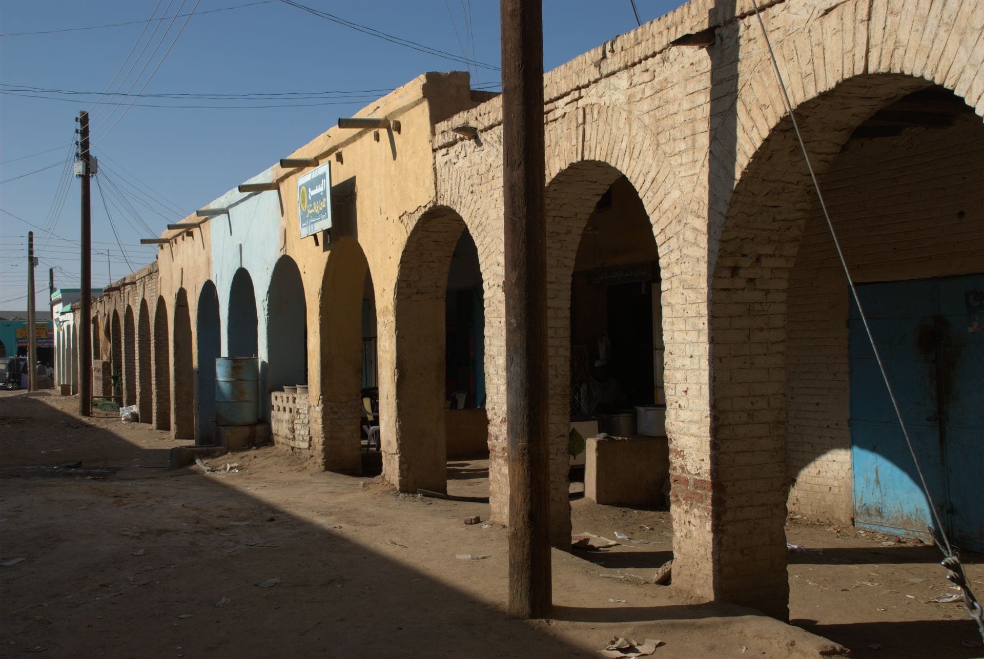
A row of arcaded mud-brick shopfronts in pale yellow and blue along a sandy street in Karima

Meroë & the North, Sudan

Karima

Arcaded shops on the market square in Karima. (Bertramz / Wikimedia Commons · CC BY 3.0)

A small town on a great loop of the Nile in Northern state, below the flat-topped sandstone hill of Jebel Barkal that Egyptians and Kushites held sacred to Amun. Temples and pyramids stand at its foot, and the royal cemeteries of Nuri and El-Kurru lie nearby. This page is written to explain the town, not to encourage travel.

Neighbourhoods

  • The market and the old town
    • First-time visitors
    • Markets
    • Local life

    The centre of Karima, a few sandy streets of arcaded mud-brick shops, tea stalls and workshops around the market square, with the bus stand nearby. Jebel Barkal rises in plain sight a short way to the south-west.

    Open in Maps
  • The riverbank and the palm groves
    • Riverside walks
    • Quiet and residential

    A green strip of date palms, wheat and vegetable plots between the town and the Nile, with pumps, mud-brick houses and boat landings. The river is wide here, and Merowe lies on the far bank.

    Open in Maps
  • Below Jebel Barkal
    • Historic district
    • Photography

    The edge of town where the fields stop and the desert begins at the foot of the mountain, with the temple ruins and the small pyramid field beside the track. A few guesthouses and a tented camp served visitors here before the war.

    Open in Maps

Things to do

Jebel Barkal

  • Jebel Barkallandmark

    The isolated sandstone hill about 3 km from the town, sacred to Amun for Egyptians and Kushites alike, with the ruined Great Temple of Amun and steep pyramids at its base; UNESCO listed it in 2003 with the other Napatan sites. The Jebel Barkal Museum is in Karima.

    Open in Maps

Royal cemeteries nearby

  • Nurilandmark

    A field of Napatan royal pyramids about 10 km from Jebel Barkal, the largest of them the tomb of Taharqa, the Kushite king who ruled Egypt in the seventh century BC.

    Open in Maps
  • El-Kurrulandmark

    The earliest royal cemetery of the Napatan kings, roughly 20 km downstream, where a decorated rock-cut burial chamber can be entered beneath the ruined pyramids.

    Open in Maps

Short trips from the town

  • Meroweattraction

    The town on the left bank opposite Karima, reached by the road bridge, with the district's offices and an airport; it is not the ancient city of Meroë, which lies far upstream.

    Open in Maps
  • Monastery in Ghazalilandmark

    The stone ruins of a Christian Nubian monastery in the Bayuda Desert south-west of the town, probably founded in the late seventh century and in use until the 13th.

    Open in Maps
  • Merowe Damlandmark

    The large hydroelectric dam completed in 2009 at the Fourth Cataract about 25 km downstream, which flooded a long stretch of the valley and displaced thousands of villagers.

    Open in Maps

Seasonal events

  • Ramadan and Eid al-Fitrvaries with the lunar calendar

    The fast is broken at sunset with dates and shared dishes, and the month ends with visiting between houses across the town and the surrounding villages.

  • Eid al-Adhavaries with the lunar calendar

    Sheep are slaughtered at home and the meat divided between the family, neighbours and the poor.

  • The date harvestroughly August to October

    The busiest weeks of the year along this reach of the Nile, when dates are cut, dried on mats and sold by the sack.

Eat and drink

Long-standing places and food districts in Karima. Hours, ratings and directions come from your maps app, always current.

Nubian and Nile-town cooking

  • Ful and bread kitchensrestaurant

    Simple eating houses near the market serve ful, mashed broad beans with oil and cumin, and a thick wheat pancake bread eaten with meat or vegetable stew poured over it.

    Open in Maps
  • Grill stallsrestaurant

    Charcoal-grilled mutton and goat sold by weight with bread, onion and salt, the standard evening meal out.

    Open in Maps

Market and street life

  • Karima marketmarket

    Dates in many varieties, wheat, broad beans, onions, spices and vegetables from the riverside plots, sold under the arcades around the square.

    Open in Maps
  • Tea and jebena stallscafe

    Low stools and charcoal stoves where sweet tea with mint or cinnamon and spiced clay-pot coffee are poured through the day.

    Open in Maps

Experience Karima

History

The land around Karima is the old heart of Kush. Egypt's New Kingdom pushed this far up the Nile around 1500 BC and identified the flat-topped hill beside the river, Jebel Barkal, as a home of the god Amun, building a great temple at its foot. When Egyptian power faded, a local dynasty rose at Napata, the settlement around the mountain, and in the eighth century BC its king Piye marched north and made himself pharaoh; his successors, among them Taharqa, ruled Egypt as its 25th dynasty and were buried under pyramids at El-Kurru and Nuri, within a few kilometres of the modern town.

Napata was sacked by an Egyptian army in 593 BC, and by about the third century BC the royal burials had moved south to Meroë, though Jebel Barkal kept its religious standing for centuries. Christian Nubian kingdoms followed, and the monastery at Ghazali in the desert valley behind the town dates from that period; Islam and Arabic spread through the region from about the 14th century, and the Shaigiya became the dominant people of this stretch of the river.

Karima itself is a modern town. It grew in the early 20th century at the terminus of a railway branch built from near Abu Hamad, becoming the transfer point between the trains and the Nile steamers that ran downstream towards Dongola, and a market for the farming villages along the bank. Archaeological excavation at Barkal, Nuri and El-Kurru from the early 20th century made its name abroad, and the UNESCO listing of 2003 brought a small stream of visitors that lasted until the war began in 2023.

Culture & Customs

Karima lies in Shaigiya country, on the edge of the Nubian-speaking north, and the two traditions meet here. Arabic is the everyday language, the Dongolawi Nubian language is spoken downstream, and families on both sides take pride in a long lineage tied to particular villages and stretches of riverbank. The Shaigiya figured prominently in the Egyptian Army and later in the Sudan Defence Force.

Houses follow the northern pattern: thick mud-brick walls around a courtyard, flat roofs, and large doors and gateways painted in bright colours and geometric patterns. Every house keeps a room for guests, and hospitality runs in a fixed order of water, tea, coffee and then food, offered to strangers as a matter of course. Weddings last several days, with a henna night and the jirtig ceremony in which the couple are adorned with red silk, gold and perfume.

Music is played on the tambour, the five-stringed lyre of the Nubian and Shaigiya north, with hand-clapping and drums, and the songs of Mohammed Wardi, the Nubian singer and cultural icon of modern Sudan, are known in every house. Islam is observed with Sufi devotion, and the domed tombs of local holy men stand at the edge of villages, drawing families to their annual commemorations. Life is lived early and late because of the heat, and a long absence in Khartoum or the Gulf followed by a return for Eid is a normal shape for a working life here.

Daily Life

Karima is a small town of a few tens of thousands of people, the market and administrative centre for the villages along this bend of the Nile and the crossing point to Merowe on the far bank. Its population has risen since 2023 with families displaced from Khartoum, and current figures are not reliable.

Farming is the base of life. A strip of fields and palm groves only a few hundred metres wide runs along both banks, growing dates above all, with wheat, broad beans, onions, spices and fodder crops watered by diesel pumps where waterwheels once turned. Livestock is kept in the villages, and the Merowe Dam downstream supplies power to the national grid. Trade, transport, government offices, schools and the hospital provide most salaried work, and remittances from relatives in Khartoum and the Gulf pay for much of the building on the edge of town. Informal gold mining in the surrounding desert has drawn workers since the 2010s.

Days start before sunrise and stop through the worst of the afternoon heat, and the evening is spent outdoors in courtyards and at tea stalls. Since 2023 fuel, electricity and medicines have been short, prices have risen steeply, and the small tourist business around the pyramids — guesthouses, drivers, guides — has disappeared entirely. Displaced families are housed with relatives, in schools and in rented rooms, straining water and food supplies in a town with little to spare.

Food

Northern cooking is plain and built on what the river grows. The characteristic bread here is a thick wheat pancake torn into pieces with a meat or vegetable stew poured over it, alongside kisra, the thin fermented sorghum flatbread eaten elsewhere in Sudan. Stews are mullah, made with okra fresh or dried and powdered as waika, with dried meat called sharmout, or with greens thickened by dakwa, the local peanut paste.

Breakfast is ful, broad beans simmered overnight and mashed with oil, cumin, white cheese and onion, eaten from a shared bowl with bread. Meat is grilled over charcoal for guests and feasts, goat and mutton above all, and fish from the Nile is fried whole. Nubian households make their own thin wheat breads and stews of molokhia greens, and wheat is more common in the north than in the rest of the country.

Dates are the pride of the region, the Barakawi variety above all, grown along the bank, eaten fresh and dried, pressed into paste, stuffed with nuts and set before every guest. Sweet tea with mint or cinnamon is drunk all day, jebena coffee is roasted, pounded with ginger and cardamom and strained through grass from a clay pot, and cold karkade, an infusion of dried hibiscus, is the usual drink against the heat. In Ramadan the fast is broken with dates and sweet drinks. Alcohol was banned under the sharia laws of 1983 and the ban was lifted for non-Muslims in 2020, although araqi, a date spirit, has long been distilled quietly in the villages.

Planning tools

Budget

Karima was one of the few places in Sudan with any tourist infrastructure before 2023 — a handful of guesthouses, a government resthouse and a tented camp below the mountain — and most visitors came on organised tours from Khartoum. The war ended that trade, and fuel and food prices have risen sharply. The figures below are pre-war, for reference only.

Daily Budget Midrange
USD 70–150 pre-war equivalent in Sudanese pounds (guesthouse or simple hotel, hired 4x4 and driver); organised tours with tented camps cost more
Daily Budget Shoestring
USD 25–45 pre-war equivalent in Sudanese pounds (Nubian guesthouse, local food, buses); no meaningful budget during the war

Do not plan travel here while the war continues; pre-war trips to the sites needed permits and cash in US dollars.

Best Time to Visit

In peacetime, November to February was the only comfortable season, with January the coolest month and low sun on the temples and pyramids early and late in the day. From April to September the heat is extreme and sand-laden winds are common. Travel is not advisable at any time while the war continues.

Suggested Number of Days

The town is small and the main sites are within a few kilometres of it, so a day or two covered them. A third allowed for the cemeteries across the river and the desert valley beyond, all of which need a vehicle.

First Visit
1–2 days
With Surroundings
3 days

Transportation

Karima is walkable in itself, and everything beyond it needs a hired 4x4 or pick-up with a driver; rickshaws and shared pick-ups serve the market and the villages along the river. A road bridge crosses to Merowe, buses ran to Khartoum across the Bayuda desert and downstream to Dongola, and the branch railway from near Abu Hamad ends in the town. Fuel shortages and checkpoints now make any journey uncertain.

There is no safe or dependable way for visitors to travel in the region at present.

Airport & Station Connections

Karima lies about 400 km north of Khartoum, reached in normal times by bus in five to seven hours on the paved road across the Bayuda desert, or by the longer Nile road through Atbara. Merowe, across the bridge, has an airport that carried occasional domestic flights and was fought over in the first days of the war in April 2023.

Walkability

The market streets are flat, small and easily walked, and the edge of the palm groves is only a few minutes away. Jebel Barkal is about 3 km from the centre, a walk possible in the cool hours but hot and exposed at any other time; the other sites are too far to reach on foot. Streets are sand, and there is almost no shade away from the river.

Safety

Do not travel. The north has seen less ground fighting than Khartoum, Darfur or Kordofan, but it is part of a country at war: the area around Merowe was fought over in the first days of the conflict in April 2023, a drone strike damaged the power station at the Merowe Dam in January 2025 and cut power as far away as Port Sudan and Atbara, and the towns are crowded with people displaced from the capital. Informal gold mining is widespread in the surrounding deserts, and medical care is scarce.

Most governments advise against all travel to Sudan, including the north, and consular help is not available. Check current official travel advice before travelling.

Climate

A hot desert with almost no rain in most years. The heat is extreme from April to September and hot winds carry sand off the Bayuda and Nubian deserts; winter days are warm and sunny and the nights by the river are cold.

Summer
extremely hot and dry, often above 40°C, with dust-laden winds
Winter
warm days around 30°C and chilly desert nights

Local Customs

This reach of the Nile is Shaigiya and Nubian country, conservative and strongly Muslim, and hospitality is a matter of honour: a stranger is given water, then tea, and often a meal before any question is asked. Modest dress covering shoulders and knees is expected, and many women wear the tobe. Alcohol was banned under the sharia laws of 1983, and the ban was lifted for non-Muslims in 2020.

A photography permit was required for travel in Sudan even in peacetime, and bridges, the dam, the airport and military sites may not be photographed; ask before photographing people or houses, and take nothing from an archaeological site.

Common Payment Methods

The currency is the Sudanese pound (SDG), which has lost most of its value. International cards and cash machines do not work because of sanctions, so the town runs entirely on cash, with US dollars historically carried in for exchange; banking has been badly disrupted by the war.