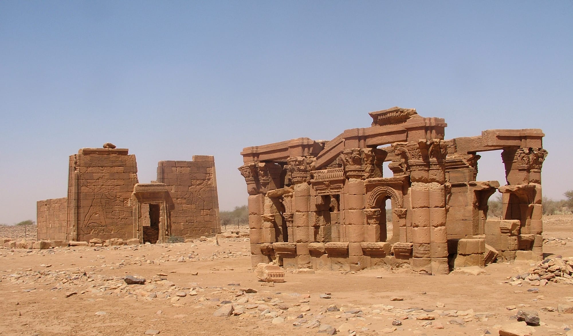
Two sandstone ruins in a stony desert under a clear sky, a columned kiosk with arches on the right and a temple gateway carved with reliefs on the left

Sudan

Meroë & the North

The Roman Kiosk and the Lion Temple of Apedemak at Naqa, a first-century Meroitic site in the desert east of the Nile. (LassiHU / Wikimedia Commons · CC BY-SA 4.0)

The desert north of Sudan, where the Nile bends through Nubia between Egypt and the edge of Khartoum — the land of the Kushite kings, with the pyramids of Meroë, the holy mountain of Jebel Barkal, the cataracts and a narrow ribbon of date palms and fields along the river. This page is written to explain the region, not to encourage travel.

Explore Meroë & the North

History

This stretch of the Nile is the cradle of Kush. From around 2500 BC a kingdom centred on Kerma, near the Third Cataract, grew rich on trade with Egypt and buried its rulers under huge mounds; Egypt's New Kingdom conquered it around 1500 BC and built temples as far upstream as Jebel Barkal, which it held sacred to Amun. When Egyptian power faded, a local dynasty based at Napata, beneath the mountain, rose in its place, and in the 8th century BC its king Piye marched north and made himself pharaoh. His successors, among them Taharqa, ruled Egypt as its 25th dynasty and were buried under pyramids at el-Kurru and Nuri.

Around the 3rd century BC the royal burials moved south to Meroë, already the capital of a kingdom with its own Meroitic script, iron furnaces, and ruling queens known as kandakes; one of them, Amanirenas, fought Rome's armies around 25 BC. Meroë declined by the 4th century AD. Christian Nubian kingdoms followed, and Makuria, ruled from Old Dongola, held Muslim Egypt at bay for centuries under a treaty known as the baqt. Its decline in the 14th century opened the way to Arab tribes and Islam.

The Ottoman-Egyptian conquest of 1820–21 met resistance at Shendi, where the local ruler burned the pasha's son to death. Kitchener's railway and army came up the Nile in the 1890s, defeating the Mahdists at Atbara in 1898, and Atbara became Sudan's railway town. In the 1960s the Aswan High Dam flooded Wadi Halfa, and the Merowe Dam of 2009 submerged the Fourth Cataract and displaced thousands of villagers.

Culture & Customs

The north is shared between Nubian-speaking and Arabic-speaking peoples. Nubian languages survive from Wadi Halfa up through Dongola — Nobiin in the far north and Dongolawi around Dongola — while further upstream the Arabic-speaking Shaigiya of the Karima and Merowe reach, the Rubatab and Manasir, and the Ja'aliyin of Shendi each keep their own proud identity. Many of Sudan's political and business elite trace their roots to these riverside towns.

Nubian villages are known for their houses: thick mud-brick walls around a courtyard, with large doors and gateways painted in bright colours and patterns. Every house keeps a guest room, and a stranger will be offered water, tea and often a meal before any question is asked. Weddings run for days, with the jirtig ceremony, in which the couple are adorned with red silk, gold and perfume, and a henna night.

Music has deep roots here. The tambour, a five-stringed lyre, accompanies Nubian and Shaigiya song, and Mohammed Wardi, a Nubian from the Wadi Halfa area, became one of the best-loved singers in the Arab and African world. Islam is observed with Sufi devotion, and the domed tombs of local holy men stand at the edge of many villages.

Daily Life

Life follows the river. A strip of fields and palm groves, often only a few hundred metres wide, runs along both banks, with desert on either side. Atbara, at the meeting of the Nile and the Atbara river, is one of the largest towns, with over 100,000 people; Shendi, Dongola, the capital of the Northern state, Ed Damer, Karima, Merowe, Berber and Wadi Halfa are smaller.

Farming is the old mainstay: dates above all, along with wheat, broad beans, onions, spices and fodder crops, watered from the Nile by diesel pumps where waterwheels once turned. Atbara has the railway workshops that made it a trade-union stronghold, and the Merowe Dam was built mainly to generate electricity. Since the 2010s a gold rush has drawn large numbers of informal miners into the Nubian and Bayuda deserts.

Emigration has long thinned the villages, with remittances from the Gulf paying for new houses. Since 2023 the north has taken in large numbers of people fleeing Khartoum, straining housing, fuel, water and prices, and many families passed through on their way to Egypt.

Food

Northern cooking is plain and built on what the river grows. Dates come in many varieties and are eaten with tea and given to guests. Broad beans, the base of ful, grow along the banks, and wheat is more common here than in the rest of Sudan.

The characteristic bread is gurasa, a pancake-like wheat bread, eaten torn into pieces with a meat or vegetable stew poured over it, while kisra, the thin fermented flatbread, is eaten as elsewhere. Nubian households make their own thin wheat breads and stews of okra, molokhia greens and dried meat. Fish from the Nile and Lake Nubia is eaten too, and lamb is slaughtered for weddings and feasts.

Sweet tea with mint, spiced jebena coffee and cold karkade (hibiscus) are the daily drinks. Aragi, a clear spirit distilled from dates, was brewed quietly in some villages despite the national ban on alcohol.

Attractions & Natural Wonders

In the Butana desert east of the Nile near Bagrawiya stand the pyramids of Meroë, rows of steep sandstone tombs on low ridges, many beheaded by a 19th-century treasure hunter, with the ruins of the royal city by the river. Nearby, Naqa has the Lion Temple of the god Apedemak and a temple of Amun, and Musawwarat es-Sufra a walled complex of courtyards and ramps. These sites form the Island of Meroë, a UNESCO World Heritage Site.

Upstream, in the great S-bend of the river, Jebel Barkal rises beside the town of Karima, with the temple of Amun and a group of pyramids at its foot, and the royal cemeteries of el-Kurru and Nuri a short drive away; together they are listed as Gebel Barkal and the Sites of the Napatan Region. Across the Bayuda desert, the ruined monastery of Ghazali lies in a dry desert valley.

Further north, Old Dongola's churches and throne-hall mosque stand on a bluff above the river, and Dongola is the modern gateway to Kerma and its Deffufa. The Nile cataracts, stretches of granite rocks and rapids, break the river at intervals: the Third near Tombos, the Fifth between Abu Hamad and Atbara, and the Second now submerged under Lake Nubia near Wadi Halfa. Between them lie the temple of Soleb and the island of Sai. All are currently beyond reach.

Cities in Meroë & the North

Planning basics

Budget

Before the war the north was the heart of Sudan's small tourist trade, with a few tented camps and Nubian guesthouses near Meroë and Karima and simple lodgings in Dongola and Wadi Halfa; most visitors came on organised tours from Khartoum. The war ended that trade, and prices for fuel and food have risen sharply. Figures are pre-war, for reference only.

Daily Budget Midrange
SDG — not meaningful during the war; pre-war roughly the equivalent of USD 70–150 (guesthouse or simple hotel, hired 4x4 and driver); organised tours with tented camps cost more
Daily Budget Shoestring
SDG — not meaningful during the war; pre-war roughly the equivalent of USD 30–50 (Nubian guesthouse, local food, buses)

Do not plan travel here while the war continues; pre-war trips to the sites needed permits and cash in US dollars.

Safety

Do not travel. The north has seen less ground fighting than Khartoum, Darfur or Kordofan, but it is part of a country at war: Merowe was fought over in the first days of the conflict, RSF drone strikes hit the Merowe Dam power station, Atbara and Dongola airport in 2025, and the region's towns are crowded with displaced people. Informal gold mining is widespread in the desert, and medical care is scarce.

Most governments advise against all travel to Sudan, including the north, and consular help is not available. Check current official travel advice before travelling.

Climate

The north is the driest part of Sudan and among the driest places on earth, with almost no rain in most years. From April to September the heat is extreme, often above 45°C around Dongola and Atbara, and hot winds carry sand off the Bayuda and Nubian deserts. Winter is dry and sunny, with cool nights by the river.

Summer
extremely hot and dry, often 42–47°C, with dust-laden winds
Winter
warm days around 25–30°C and chilly desert nights, sometimes near 10°C

Transportation

Paved highways run from Khartoum north along the Nile through Shendi and Atbara, and across the Bayuda desert to Karima and Dongola, then on to Wadi Halfa and the land crossings into Egypt, which carried huge numbers of people fleeing the war in 2023. A railway links Atbara with Wadi Halfa, and Merowe has an airport. Fuel shortages and checkpoints make any journey uncertain.

There is no safe or dependable way for visitors to travel in the region at present.

Best Time to Visit

In peacetime, November to February was the only comfortable season for the pyramids, temples and desert tracks, with January the coolest month. Travel is not advisable at any time while the war continues.