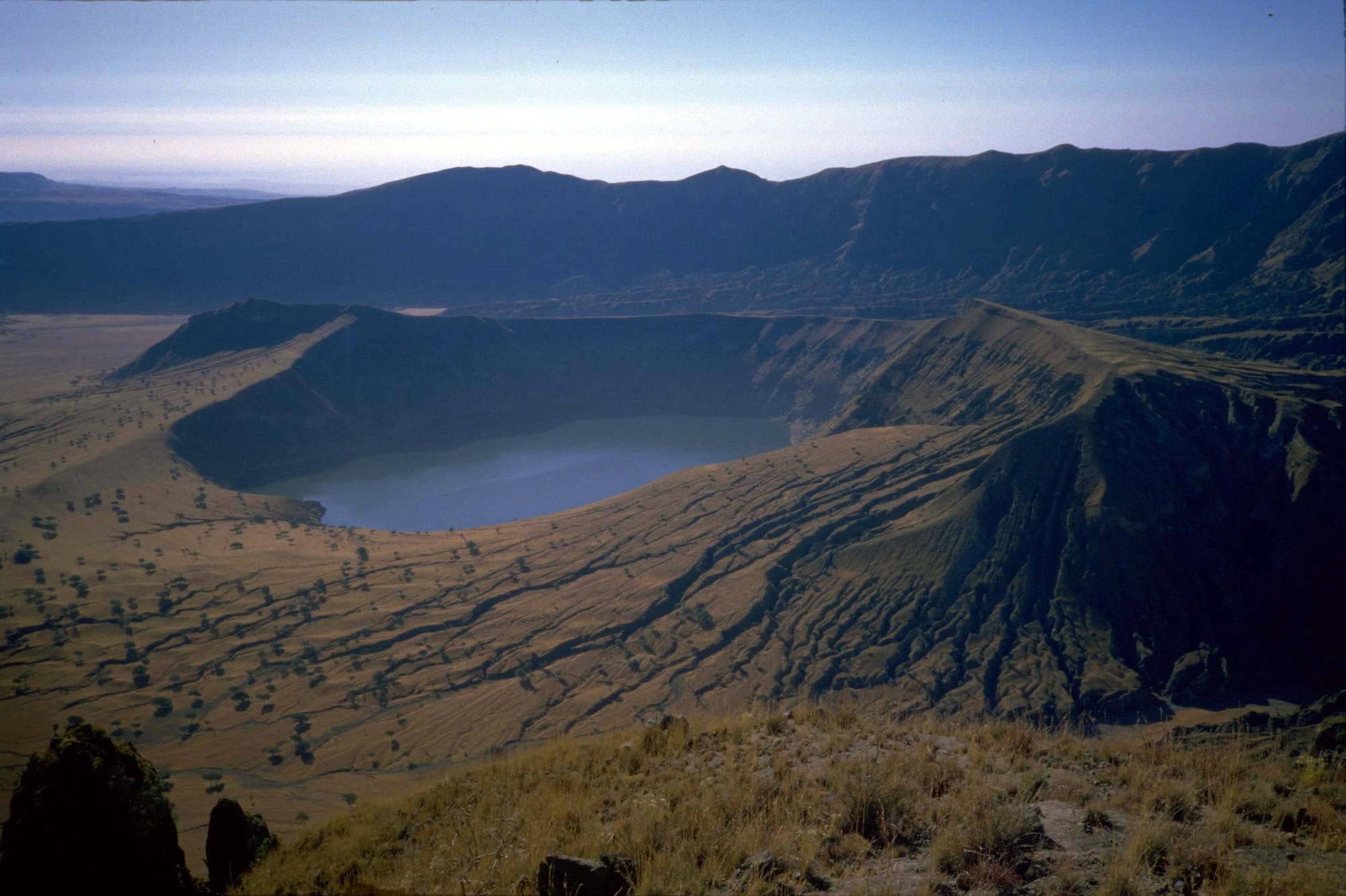
A deep volcanic crater holding a blue lake, ringed by steep dry slopes and ridges under a pale sky

Sudan

Darfur & Kordofan

The Deriba caldera and its crater lake at the summit of Jebel Marra, Darfur. (J Williams / Wikimedia Commons · CC BY-SA 3.0)

The vast west of Sudan, from the sultanate lands of Darfur and the volcanic Jebel Marra to the gum-arabic savannah of Kordofan and the Nuba mountains near the South Sudan border — home to farmers and camel and cattle herders, and the scene of Sudan's worst violence since 2003. This page is written to explain the region, not to encourage travel.

Explore Darfur & Kordofan

History

Early states grew around Jebel Marra, where the Daju and then the Tunjur kings ruled before the Keira dynasty of the Fur founded a sultanate by the 17th century. Darfur's sultans grew rich on the Forty Days Road, the camel route to Egypt that carried ivory, ostrich feathers and enslaved people, and in the late 18th century they fixed their capital at El Fasher. Kordofan, between Darfur and the Nile, was fought over by the Fur and the Funj of Sennar, while the Nuba hills sheltered their own chiefdoms, including the kingdom of Taqali.

Egyptian rule reached Kordofan in 1821 and Darfur in 1874, when the slave trader Zubayr Pasha defeated the sultan. Kordofan became the cradle of the Mahdist revolt: the Mahdi took El Obeid in 1883 and later that year destroyed an Egyptian army under Hicks Pasha at Shaykan nearby. After the Mahdist state fell, Ali Dinar revived the Darfur sultanate in 1898, until British forces killed him in 1916 and Darfur was joined to Sudan.

Neglect after independence fed rebellion. In the Nuba mountains war came with the southern civil war in the 1980s and resumed in 2011. In Darfur, rebels rose in 2003, and government forces and Janjaweed militias answered with a campaign of killing and burning that led to genocide charges against Omar al-Bashir. The Janjaweed were later reorganised as the Rapid Support Forces, and since April 2023 their war with the army has brought new massacres, including in El Geneina, a siege of El Fasher that ended when the RSF took the city in October 2025 and killed thousands of civilians, and fighting across Kordofan. The Abyei Area, on the border south of West Kordofan, is claimed by both Sudan and South Sudan and has had a special administrative status since the 2005 peace agreement.

Culture & Customs

The west is one of Sudan's most varied regions. In Darfur, the Fur of Jebel Marra, the Masalit around El Geneina and the Zaghawa of the northern desert speak their own languages alongside Arabic, while Arab tribes such as the Rizeigat herd camels in the north and cattle in the south. In Kordofan the cattle-herding Baggara, among them the Misseriya and Hawazma, share the land with settled farmers, and the Nuba mountains hold dozens of peoples speaking many different languages, Muslim and Christian alike.

Relations between herders and farmers, once managed by customary agreements over grazing routes and water, turned violent as drought, guns and politics pressed on the land, and ethnic identity became a line of war. Yet the region shares traditions, among them Islam and a strong code of hospitality.

The Nuba are known for their passion for wrestling, and Nuba communities have practised body painting and scarification. Across the region, weekly markets are the great social occasion, and harvest festivals, horse and camel racing and drumming mark the end of the rains.

Daily Life

Before the war Nyala, El Fasher and El Obeid were each cities of several hundred thousand people, with El Geneina, Zalingei, Ed Daein, Kadugli, Dilling, El Fula and En Nahud the other main towns. Hundreds of thousands of Darfuris had lived in displacement camps since the 2000s.

The economy rests on land. Kordofan's savannah is a heartland of Sudan's gum arabic, about 70% of world supply, tapped from acacia trees and sold in El Obeid, along with groundnuts, sesame and millet; herders move cattle, camels and sheep along seasonal routes, and livestock is a major export. Oil fields lie in West and South Kordofan, and gold mining spread across Darfur and the Nuba mountains in the 2010s.

The war has destroyed much of this. Millions have been displaced, many across the border into Chad, markets and hospitals have been looted, harvests lost, and famine confirmed in camps such as Zamzam near El Fasher. Aid reaches the region only in part, and the RSF and allied groups have announced a rival government in the areas they hold.

Food

The staple is millet or sorghum cooked into asida, a stiff porridge shaped in a bowl and eaten with mullah, a thick stew; in Darfur the stew is often made with dried okra or dried meat, called sharmout. Kawal, a pungent fermented food, gives many western stews their deep flavour, and groundnuts are ground into sauces and dressings.

Herding families live on milk: fresh and soured cow's milk among the Baggara, camel's milk in the north, and butter made from both. Meat is roasted at feasts and weddings, and dried strips are kept for the lean season. Jebel Marra's cooler slopes grow fruit and vegetables.

Kordofan's drinks are its own. Karkade, made from hibiscus flowers, is drunk hot or cold, and sweet tea and spiced coffee go with every visit.

Attractions & Natural Wonders

Jebel Marra is Darfur's great natural sight: a volcanic massif rising to about 3,000 metres from the plains, with perennial streams, and at its summit the Deriba caldera, a double crater holding two lakes. North of it, El Fasher grew around the sultans' palace, and further north the Meidob hills hold the Malha crater lake. Nyala, south of Jebel Marra, was the region's largest market town, and Radom National Park lies on the Central African border at the far south of Darfur.

In Kordofan, El Obeid has a large market and one of Sudan's oldest cathedrals, and the battlefield of Shaykan lies nearby. Around it stretches the gum-arabic country of North Kordofan, a sandy savannah of acacia trees, baobabs and millet fields dotted with villages.

To the south, the Nuba mountains rise as clusters of granite hills from the plain around Kadugli and Dilling, with villages of round thatched houses built among the boulders, terraced fields, and wrestling grounds. None of it can be visited while the war continues.

Cities in Darfur & Kordofan

Planning basics

Budget

Even before 2023 the west had almost no visitor trade: Darfur needed special permits after 2003 and was visited mainly by aid workers and peacekeepers, whose presence pushed up rents in El Fasher and Nyala. Today markets have been looted or burned, food is scarce and prices are extreme. The figures below are pre-war, for reference only.

Daily Budget Midrange
SDG — not meaningful during the war; pre-war roughly the equivalent of USD 70–150 (guesthouse, hired vehicle and driver)
Daily Budget Shoestring
SDG — not meaningful during the war; pre-war roughly the equivalent of USD 30–50 (simple lodging, market food, buses)

Do not plan travel to Darfur or Kordofan; there is no visitor economy and no safe way in.

Safety

Do not travel. Darfur and Kordofan are among the most dangerous places in the world. Since 2023 the Sudanese Armed Forces, the Rapid Support Forces and allied militias have fought across both regions, with sieges of cities, drone and air strikes, looting, ethnic massacres and widespread sexual violence; famine has been confirmed in displacement camps. South Kordofan also has a separate insurgency, and unexploded ordnance lies across former battlefields.

Most governments advise against all travel to Sudan, and there is no consular help anywhere in the region. Check current official travel advice before travelling.

Climate

Rain increases steadily from north to south. North Darfur and North Kordofan are semi-desert with short, unreliable summer rains, while South Darfur, West Kordofan and the Nuba mountains are savannah, green from June to October. Jebel Marra is cooler and wetter than the plains around it. Rains cut dirt roads for months, and April to June is fiercely hot.

Summer
very hot before the rains, often 40°C; rains from about June to October, heavier in the south
Winter
dry and warm, around 30°C by day, with cool nights and dusty harmattan winds

Transportation

A railway runs from Khartoum to El Obeid and from Babanusa south-west to Nyala, and El Obeid, El Fasher and Nyala have airports, but most of the region depends on dirt roads that flood in the rains. Since 2023 roads, railways and airports have been fought over, and aid convoys are often blocked.

There is no safe way for visitors to enter or travel in the region.

Best Time to Visit

In peacetime, November to February was the best season, after the rains and before the heat, when roads were passable and Jebel Marra was green. Travel is not advisable at any time while the war continues.