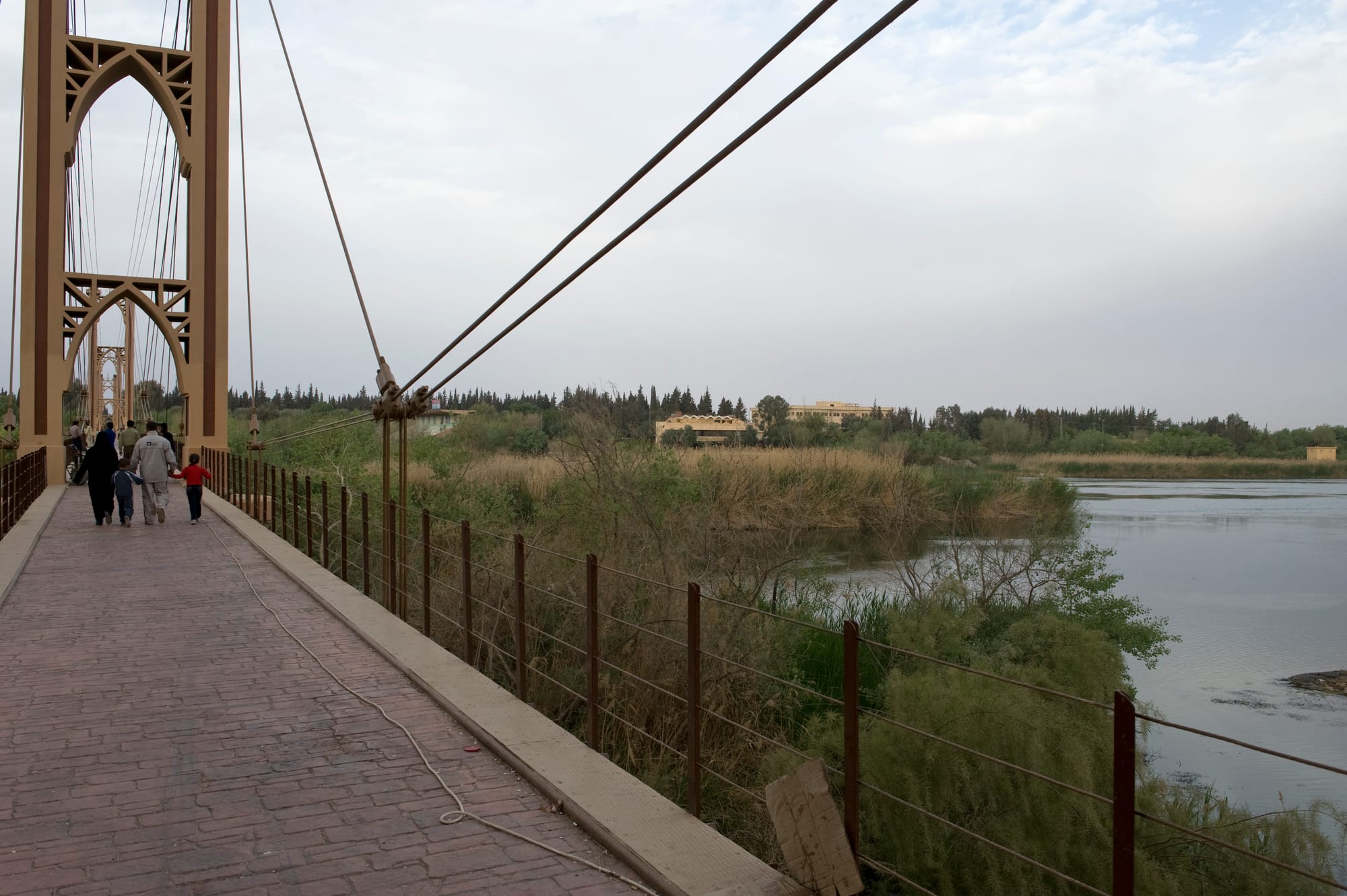
The brick-paved walkway and yellow steel tower of a suspension footbridge, with the Euphrates and green riverbank trees beyond

The Euphrates & the Northeast, Syria

Deir ez-Zor

The French-built suspension bridge over the Euphrates at Deir ez-Zor, photographed before the war. (Dosseman / Wikimedia Commons · CC BY-SA 4.0)

The main city of eastern Syria, spread along the Euphrates where the river crosses desert on its way to Iraq. It grew under late Ottoman rule as an administrative and trading centre, became a byword for the end point of the Armenian deportations, and served archaeologists working at Dura-Europos and Mari. This page is written to explain the city, not to encourage travel to it.

Neighbourhoods

  • The centre and the corniche
    • First-time visitors
    • Close to transport
    • River views

    The commercial heart on the right bank, a grid of shops, offices, hotels and cafés running back from the riverside road. The corniche along the Euphrates, with its trees and benches, has long been where the city takes its evening walk.

    Open in Maps
  • Al-Joura and the older quarters
    • Local life
    • Markets

    The dense older districts west and south of the centre, built up through the 20th century in low concrete houses along narrow streets, with neighbourhood markets and bakeries. These quarters saw heavy fighting and rebuilding is uneven.

    Open in Maps
  • The left bank and the island
    • Quiet and residential
    • Riverside

    Across the river lie farmland, gardens and the suburbs that spread towards Hasakah, linked by the road bridges. The wooded island and riverbanks in between were the city's traditional picnic ground.

    Open in Maps
  • The northern edge
    • Quiet and residential

    Newer housing, the university buildings and the roads out towards Raqqa and the desert, where the city thins into irrigated fields and then into steppe.

    Open in Maps

Things to do

In the city

  • Deir ez-Zor Suspension Bridgelandmark

    A French-built pedestrian suspension bridge of 1927 that crossed the Euphrates and became the city's emblem; it was destroyed in 2013 during the war.

    Open in Maps
  • The Euphrates cornicheattraction

    The riverside promenade through the middle of the city, lined with trees and cafés and the usual place for an evening walk beside the water.

    Open in Maps
  • Deir ez-Zor Museummuseum

    The regional archaeological museum, founded in 1974 and housed since 1996 in a purpose-built building, holding most of the clay tablets found at Mari along with finds from Dura-Europos and the tells of the Khabur.

    Open in Maps

Ancient sites downstream

  • Dura-Europoslandmark

    A Hellenistic and Roman frontier town on a cliff above the river downstream, where excavators found a painted synagogue and one of the earliest known house-churches.

    Open in Maps
  • Marilandmark

    The mud-brick remains of a Bronze Age city-state at Tell Hariri near the Iraqi border, whose palace archive of tablets records the age of Hammurabi.

    Open in Maps

Upstream

  • Halabiyelandmark

    A fortified city upstream on the right bank, known in antiquity as Zenobia after the Palmyrene queen who fortified it in the 3rd century, its walls climbing a bluff above a narrow stretch of the valley and refortified under Justinian.

    Open in Maps
  • Al-Mayadinattraction

    A river town downstream from the city, near the medieval fortress of Rahba on the desert edge.

    Open in Maps
  • Terqalandmark

    A tell on the Euphrates downstream, the site of an ancient walled town in the orbit of Mari, excavated for its temple and archives.

    Open in Maps

Eat and drink

Long-standing places and food districts in Deir ez-Zor. Hours, ratings and directions come from your maps app, always current.

Euphrates classics

  • River fishrestaurant

    Carp and other Euphrates fish are split, seasoned and grilled over wood, traditionally eaten at simple places along the river rather than in the centre.

    Open in Maps
  • Desert trufflesmarket

    After good winter rains the steppe produces kama, desert truffles gathered and sold by the kilo in spring and cooked with meat or rice.

    Open in Maps

Markets and food streets

  • The central market streetsneighborhood

    Grills, shawarma counters, bakeries and juice stands cluster in the blocks behind the corniche, alongside sellers of dates, nuts, sheep's-milk cheese and dried yoghurt.

    Open in Maps
  • The produce marketmarket

    Vegetables, melons and cucumbers from the irrigated river gardens, wheat and burghul from the plains, and sacks of spices for the lamb dishes of the east.

    Open in Maps

Experience Deir ez-Zor

History

Deir ez-Zor grew where the Euphrates offered a crossing between the Syrian steppe and the Jazira plains, on a route travelled since antiquity by traders between Mesopotamia and the Mediterranean. The valley around it was old country — Mari downstream was a rich city-state in the third and second millennia BC, and Dura-Europos a Seleucid foundation that became a Roman garrison facing Persia — but the town itself was a modest riverside settlement for most of its history.

Its rise came under late Ottoman rule in the 19th century, when the government made it the seat of the Zor Sanjak, a district answering directly to Istanbul and created to bring the Euphrates tribes under administration. Officials, garrisons, merchants and craftsmen arrived, a riverside quarter of markets and khans took shape, and the town became the recognised capital of the Syrian east. In 1915 and 1916 the deserts around it became the end point of the Armenian deportations, and the name of the city has carried that meaning ever since; an Armenian genocide memorial church was built there in 1991 and was destroyed in 2014.

The French mandate added the suspension bridge of 1927, a landmark for generations, and made the city a base for the archaeologists excavating Mari, Dura-Europos and the tells of the Khabur. After independence, oil and gas discovered in the surrounding desert and irrigation along the river made the province economically important, and the city grew quickly. From 2011 it was fought over repeatedly, much of it was destroyed, and the suspension bridge was brought down. Rebuilding has gone on since, much of it by residents themselves.

Culture & Customs

The city belongs to the tribal Arab world of the Euphrates rather than to the merchant cities of western Syria, and the difference is audible in the dialect, which is closer to the speech of Iraq than to that of Damascus. Large tribal confederations such as the Uqaidat and the Baggara have long shaped politics, marriages, land and the settling of disputes, and a mediated tribal settlement is still often preferred to a court.

Hospitality follows a formal pattern: guests are received in a reception room or tent, bitter coffee scented with cardamom is poured in small quantities from a long-spouted pot, and a sheep may be killed for an honoured visitor. Meals are eaten from a shared tray, with guests served first and pressed to eat more. Poetry in the Bedouin manner, recited and sung, is a respected accomplishment, and weddings bring drumming, line dancing and processions through the streets.

Society here is conservative and family-centred, and religious observance is mainstream Sunni Islam; small Christian and other communities lived in the city before the war. The river itself is part of local identity — swimming, fishing, picnics on the banks and the evening walk along the corniche — and the destruction of the suspension bridge was felt as the loss of a symbol rather than just a crossing. Memory of the Armenian deportations gives the city a place in another people's history, marked each April by Armenians worldwide.

Daily Life

Deir ez-Zor is the largest city of eastern Syria and the seventh largest in the country. The war displaced most of them at one time or another; many have returned to damaged homes and neighbourhoods, and the population now is uncertain. The city is overwhelmingly Arab, with strong ties between urban families and the villages along the river.

Its economy rests on the river and the desert. Irrigated farming on both banks produces wheat, cotton, vegetables and melons; the oil and gas fields of the province supplied much of Syria's output before the war and their revenues have long been contested; and the city lives on trade, transport, government offices and, in recent years, on aid and reconstruction work. Jobs are scarce and much work is informal.

Daily life starts early to beat the heat, with markets and fieldwork in the morning, a long quiet afternoon and families out on the corniche and on roofs after dark. Electricity and water supply are intermittent, and generators and tankers fill the gaps. The dominant concerns are clearing rubble and unexploded ordnance, restoring the river crossings, housing and property disputes, the fate of people detained or missing, and the pace at which services return.

Food

Eastern Syrian cooking is plainer than that of Aleppo or Damascus and closer to the food of Iraq and the Bedouin. The centrepiece of any feast is lamb or mutton, boiled or slow-cooked in a large pot and served on a mound of rice or over layers of flatbread soaked in broth, eaten with the hand from a shared tray. Ouzi and similar rice-and-meat dishes appear at weddings, and grilled kebab and kofta are the everyday restaurant food.

The Euphrates gives the city its distinctive dish: carp and other river fish split open, salted and grilled slowly over a wood fire by the water, a method shared with the Iraqi masgouf. In spring, after good rains, kama — desert truffles gathered from the steppe — are sold by the sack in the markets and cooked with meat or rice. Dairy from sheep and goats comes as laban, thick strained labneh, salty cheeses and kishk, dried yoghurt and burghul, which is reconstituted into a winter soup.

Bread is baked on the wall of a clay tannour oven and eaten with everything. Wheat from the plains becomes burghul and freekeh; river gardens supply tomatoes, cucumbers and the melons the valley is known for; and dates, figs and pistachios fill the sweet shops alongside simple semolina pastries. Tea, strong and very sweet, is drunk all day, and the bitter cardamom coffee of the tribes opens and closes every formal visit.

Planning tools

Budget

The east never had much of a visitor trade — a few simple hotels served archaeologists, traders and officials, and most of that is gone. The real costs of any stay are a trusted fixer, a driver and a vehicle, since distances are long and the roads need local knowledge. Everything is paid in cash. Figures are indicative only.

Daily Budget Midrange
USD 120–250 (better hotel, fixer, car and driver) — indicative only
Daily Budget Shoestring
USD 30–50 (basic hotel, local food, shared transport) — indicative only

Carry all money as clean US dollar notes and budget generously for a fixer and driver, the one cost that cannot be cut; a redenominated pound with two zeros removed replaced the old notes during 2026.

Best Time to Visit

Historically March to April, when the desert briefly greens and the heat has not arrived, and October to November once summer has broken. Midsummer on the Euphrates is punishing and dust storms blow in spring and early summer. Security conditions, not the season, decide whether any visit is possible.

Suggested Number of Days

A day or two covers the city itself, much of which is still being rebuilt. Three or four days allow the sites strung along the Euphrates both upstream and downstream, which are far apart and slow to reach by road.

First Visit
1–2 days
With Surroundings
3–4 days

Transportation

Roads follow the Euphrates from Raqqa down through the city to Abu Kamal on the Iraqi border, with another road north through the Khabur valley to Hasakah. Bridges over the river were destroyed in the war and some crossings remain makeshift, and checkpoints punctuate every route. Shared taxis and minibuses link the towns; within the city, taxis are the normal way to move.

Move only with a local fixer who knows the current checkpoints and road conditions, and only in daylight.

Airport & Station Connections

Deir ez-Zor has an airport about 10 km south-east of the city, long out of normal commercial use, so almost all arrivals are overland. The main approaches are the desert road from Damascus and Palmyra, the river road from Raqqa and Aleppo, and the route south from Hasakah and Qamishli, whose airport passed back to the national civil aviation authority in February 2026 in preparation for civilian flights. Journeys are long and checkpoints add hours.

Walkability

The centre and the corniche are flat and walkable, and the grid of the commercial streets is easy to follow. Beyond them the city is spread out along the river and taxis are needed. Damaged buildings, rubble and unmarked ground make wandering unwise, and summer heat rules out walking in the middle of the day.

Safety

Most governments advise against all travel to this part of Syria. The city and its province were fought over for years, much of the built area was destroyed, and the ruins, former front lines and desert beyond are heavily contaminated with mines and unexploded ordnance. Cells of the former ISIS insurgency have continued attacks in the surrounding desert, and kidnapping, tribal disputes and crime are further risks. Consular help is absent.

Do not travel for leisure; anyone who must go should do so only with an experienced local fixer and security advice, keep off unmarked ground, and never touch debris. Check current official travel advice before travelling.

Climate

Desert climate in a river valley: very hot, dry summers, short cool winters with little rain, and big differences between day and night. Dust storms are common in spring and early summer, and the river makes the immediate riverside a few degrees more bearable than the steppe.

Summer
very hot and dry, often 40–45°C by day, with warm nights
Winter
cool, roughly 3–14°C, with frosty nights and the year's little rain

Local Customs

This is Arab tribal country, and tribal identity shapes hospitality, marriage and the settling of disputes. Guests are received formally, with bitter cardamom coffee poured from a long-spouted pot and a meal of rice and lamb eaten from a shared tray, the guest served first. Society is conservative: modest dress covering shoulders and knees is expected, and most women cover their hair.

Ask before photographing people, especially women, and never photograph soldiers, checkpoints, bridges or damaged areas. Alcohol is not part of public life here; accept at least one cup of coffee when it is offered.

Common Payment Methods

The currency is the Syrian pound, redenominated in 2026 with two zeros removed. Everything is paid in cash, international cards do not work and ATMs cannot be relied on, so visitors bring clean US dollar notes and change them through trusted local channels. Prices and exchange rates move quickly.