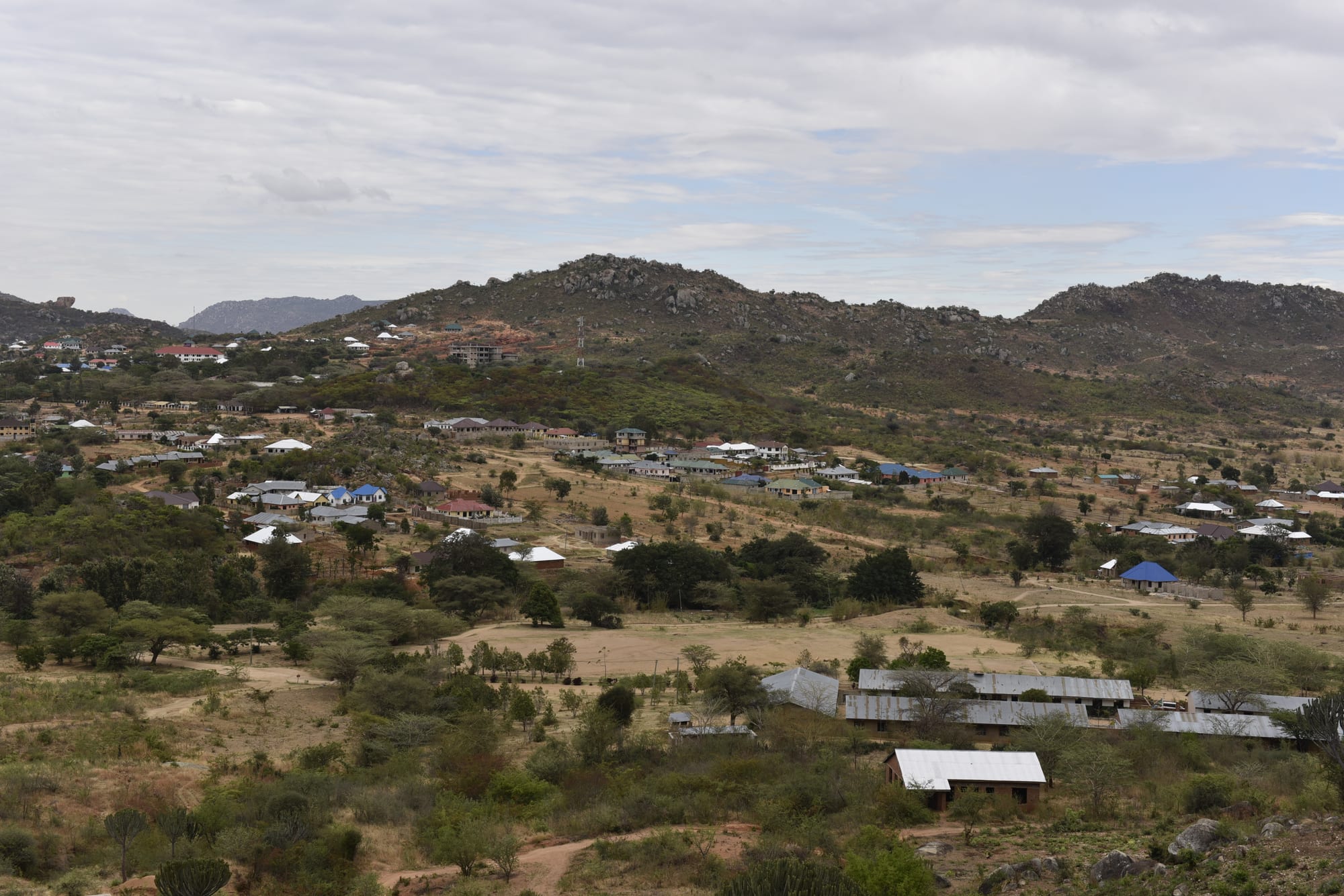
A town of scattered metal-roofed houses spread across dry green slopes below rounded rocky hills under a cloudy sky

The Southern Highlands & the South, Tanzania

Iringa

Iringa spreading across the highland slopes below its rocky hills. (Travis cardy1 / Wikimedia Commons · CC BY-SA 4.0)

A highland town in southern Tanzania, built on a rocky escarpment about 1,600 metres above sea level on the road between Dar es Salaam and Mbeya. It grew from a German garrison established during the war against the Hehe leader Mkwawa, and is now a cool, compact regional and university town and the usual base for visits to Ruaha National Park.

Neighbourhoods

  • The town centre
    • First-time visitors
    • Markets
    • Historic district

    A small grid of streets on the plateau top, with the market, banks, bus offices, cafés and the older German-era administrative buildings. It is the part of Iringa most visitors see, walkable end to end in a quarter of an hour.

    Open in Maps
  • The market quarter
    • Markets
    • Local life
    • Crafts

    The blocks around the municipal market, busiest in the morning, where produce from the highlands is traded alongside baskets, cloth and household goods. Small eating houses and tea stalls serve traders and travellers off the buses.

    Open in Maps
  • The escarpment edge
    • Views
    • Quiet and residential

    Streets running out to the lip of the plateau, where the ground drops away towards the Little Ruaha valley. Houses, guesthouses and schools look out over rocks and open country, and the light in the late afternoon is the town's best feature.

    Open in Maps
  • The university side
    • Students
    • Quiet and residential

    The neighbourhoods around the University of Iringa and the town's other colleges, with student housing, small shops, printing kiosks and bars, busier in term time and noticeably quiet in the holidays.

    Open in Maps

Things to do

In and around the town

  • Gangilonga Rockviewpoint

    The great stone on the hillside above the town, a well-known landmark run as a tourist site, and the widest view over Iringa.

    Open in Maps
  • University of Iringaattraction

    A Lutheran-founded university in the town, one of the institutions that give Iringa its student population.

    Open in Maps
  • Iringa Airporttransit hub

    The small airport at Nduli outside the town, used by domestic flights and by light aircraft serving the southern parks.

    Open in Maps

Prehistory and the Hehe

  • Isimila Stone Age Siteattraction

    A gully south-west of town where Acheulean hand-axes, cleavers and other Middle Pleistocene stone tools hundreds of thousands of years old were excavated, set among eroded sandstone pillars and canyons.

    Open in Maps
  • Kalengaattraction

    Mkwawa's fortified capital west of Iringa, destroyed by German forces in 1894, where a small museum keeps the chief's returned skull and other relics.

    Open in Maps

Short trips from the town

  • Ruaha National Parkpark

    One of Tanzania's largest national parks, named after the Great Ruaha River along its south-eastern edge, known for lions, elephants and greater kudu.

    Open in Maps
  • Udzungwa Mountains National Parkpark

    A steep forested range with waterfalls, walking trails and endemic primates, quite unlike the dry country around Iringa.

    Open in Maps

Eat and drink

Long-standing places and food districts in Iringa. Hours, ratings and directions come from your maps app, always current.

Markets

  • Iringa municipal marketmarket

    Highland produce in quantity — potatoes, maize, beans, cabbages, tomatoes, avocados and fruit — with baskets and woven goods sold around the edges.

    Open in Maps

Food districts and grills

  • Town-centre eating housesneighborhood

    Small restaurants and tea rooms around the market and the bus offices serve ugali with beans and greens, rice and stew, chapati, samosas and chai.

    Open in Maps
  • The nyama choma barsneighborhood

    Open-air bars on the edges of town grill goat and beef over charcoal and serve it with kachumbari and chips or grilled bananas.

    Open in Maps

Experience Iringa

History

The country around Iringa has been inhabited for an extraordinarily long time: at Isimila, a short way south-west, archaeologists excavated Acheulean hand axes and cleavers left by early humans in the Middle Pleistocene, in a gully now known for its eroded sandstone pillars. In the 19th century the highlands became the heartland of the Hehe, whom Munyigumba and then his son Mkwawa welded into a powerful military state that dominated the surrounding peoples.

Mkwawa's forces ambushed and destroyed a German column at Lugalo in 1891, one of the worst defeats colonial troops suffered in East Africa. The Germans returned in force, storming his fortified capital at Kalenga in 1894, and pursued him until he died in 1898 rather than be captured. His skull was taken to Germany and returned in 1954, and is kept in the small museum at Kalenga. To avenge Zelewski's death and impose their authority the Germans had meanwhile built a military station at Neu Iringa on the defensible escarpment, and that garrison post became the modern town, with its boma and its grid of streets.

Under British rule Iringa remained a modest highland centre for the farms around it. After independence it grew as the capital of Iringa Region, as a stop on the tarred highway to Zambia and Malawi, and as a base for Ruaha. Universities and colleges opened in recent decades, missions and aid organisations established offices, and the town has grown steadily without losing its small, cool, hilltop character.

Culture & Customs

Iringa is the town of the Hehe, whose name is said to come from their war cry and whose 19th-century resistance is taught across Tanzania. Mkwawa is a national figure, and locally he is more than that: the museum at Kalenga, the great rock above the town, and the story of his skull's return are part of everyday identity. Neighbouring peoples include the Bena of Njombe to the south and the Kinga of the mountains.

Christianity shapes public life. Lutheran and Catholic missions established schools, hospitals and later universities here, and church choirs, weddings and Sunday services fill the town's weekends. Iringa also has a long-standing Muslim community from the caravan and colonial era, and a small Asian trading presence whose shops line parts of the centre.

The town's other character comes from its students and its visitors. Several universities and colleges give it a young population in term time, with cheap eating houses and bars to match, and the flow of travellers heading for Ruaha has supported craft shops, basket weaving and cultural tourism projects in the villages nearby. Manners are unhurried and formal: greetings first, respect for elders, and modest dress in a highland climate where people cover up against the cold anyway.

Daily Life

About 200,000 people live in Iringa municipality, making it one of the larger towns of the Southern Highlands but far smaller than Mbeya. Government offices, schools, universities, hospitals and the transport trade along the highway provide most formal employment, alongside shops, markets and a growing tourism business.

The economy around the town is agricultural. The highlands grow maize, potatoes, beans, sunflowers, vegetables and fruit, with tea estates at Mufindi to the south-west and timber plantations on the plateau, and much of the produce moves out by lorry along the Dar es Salaam road. Livestock, dairy and small processing plants add to the trade, and Iringa is a stop for freight moving between the coast, Zambia and Malawi.

Days begin cold and early, the market fills by mid-morning, and the afternoon brings buses through town and students out of lectures. Housing spreads down the slopes and along the approach roads, and water and road maintenance struggle to keep up. Current concerns include the flow of the Great Ruaha River, which has declined with irrigation upstream in the Usangu wetlands, soil erosion on steep farmland, highway accidents, and the seasonal work that draws young people away to the cities.

Food

Iringa eats highland food, heavier and more vegetable-rich than the coast. Ugali from local maize is the staple, eaten with beans, cowpeas, pumpkin leaves, cabbage or a stew of beef or goat, and potatoes appear at nearly every meal — boiled, in stews, or fried as chips and served with eggs as chipsi mayai. Avocados, tomatoes and fruit from the surrounding farms are cheap and abundant.

Grilled meat is the sociable food here as elsewhere in Tanzania: goat or beef roasted over charcoal, chopped on a board and eaten with kachumbari, the raw tomato and onion salad, at the bars on the edge of town. Breakfast is chai with milk, chapati, mandazi or a samosa, and roasted maize is sold at roadsides.

The regional drink is ulanzi, a mildly alcoholic wine tapped from young bamboo shoots in the rainy season and drunk fresh, sweet and cloudy; it is a speciality of the Southern Highlands and is sold at roadside stalls in season. Local beers and home-brewed maize and millet beers are drunk too, and the tea grown at Mufindi and coffee from the region's farms are widely available.

Highland markets also sell honey, sunflower oil pressed locally, dried fish carried up from the rivers and lakes, and in the cold months the hot, thick porridges of maize or millet, uji, that are eaten early in the morning.

Planning tools

Budget

Iringa is cheap to stay in and eat in, with guesthouses, mid-range hotels and a few comfortable lodges outside town. The costs come from the parks: Ruaha's entry fees, a vehicle and a guide add up quickly, and most visitors arrange a safari through an operator in town.

Daily Budget Midrange
USD 75–170 (hotel, restaurant meals, taxis and local excursions; park safaris cost far more)
Daily Budget Shoestring
USD 25–45 (guesthouse, local food, buses and the market)

Compare road-based safaris arranged in Iringa with fly-in packages, since the local operators are usually far cheaper; carry cash, as cards work only in the larger hotels.

Best Time to Visit

June to October is dry and clear, the best stretch for Ruaha, when grass is low and animals gather at the river, though highland nights are cold. The rains from about December to April bring green hills, mud on side roads and the season for bamboo wine, and some park camps close.

Suggested Number of Days

A night or two covers the town and its immediate surroundings. Four or five days suit a stay that also takes in the national park to the west, which needs at least two full days to be worth the drive.

First Visit
1–2 days
With Surroundings
4–5 days

Transportation

The centre is small enough to walk, and motorcycle taxis, three-wheelers and shared minibuses cover the rest of the town cheaply. Long-distance buses on the Dar es Salaam–Mbeya highway stop here, and vehicles for the parks are hired with a driver, since the roads west are rough and distances long.

Agree fares before setting off, and hire a four-wheel-drive with a driver for the park roads rather than attempting them in an ordinary car.

Airport & Station Connections

Iringa lies a few kilometres off the main highway from Dar es Salaam to Mbeya, roughly 500 km from the coast, and buses make the journey in most of a day. Iringa Airport at Nduli, north-east of the town, takes domestic flights and light aircraft, and light planes also serve airstrips in the parks.

Walkability

The centre is compact, flat on top of the plateau and pleasant to walk in the cool highland air, with the market, hotels and bus offices close together. Streets beyond it climb and fall steeply, and the edges of town are further apart than they look. Pavements are uneven and lighting thin after dark.

Safety

Iringa is a quiet town with little crime beyond opportunistic theft around the market and bus stands. The main practical danger is the highway: the Dar es Salaam–Mbeya road carries heavy lorry traffic and sees frequent serious accidents. Malaria is less of a risk at this altitude than in the lowlands but is present in the valleys nearby.

Keep well away from the Mozambique border areas of Mtwara and Ruvuma, drive only by day, and follow guides' instructions in the parks. Take warm clothing for highland nights and malaria precautions for trips down into the valleys. Check current official travel advice before travelling.

Climate

Cool for the tropics, thanks to an altitude of about 1,600 metres, with a single rainy season and a long dry season. Days are mild rather than hot and nights can be genuinely cold, particularly in the middle of the year.

Summer
December to March is the warm, wet season, with days around 25–27°C and heavy afternoon rain
Winter
June to August is dry and cool, with days around 22–24°C and nights that can drop to 8–10°C

Local Customs

This is Hehe country, and Mkwawa's resistance to German rule is a source of considerable local pride. Christianity is strong, with Lutheran and Catholic churches long established, and Sunday is quiet. Swahili is used everywhere, greetings come before business, and elders are addressed with shikamoo.

Dress warmly in the evening and modestly in town, ask before photographing people or the museum's relics at Kalenga, and follow the guides' rules at the prehistoric site.

Common Payment Methods

The currency is the Tanzanian shilling. Banks and ATMs are in the town centre and are generally reliable, and larger hotels and safari operators take cards or ask for US dollars. Markets, minibuses, guesthouses and small restaurants are cash, and mobile money is used by almost everyone locally.