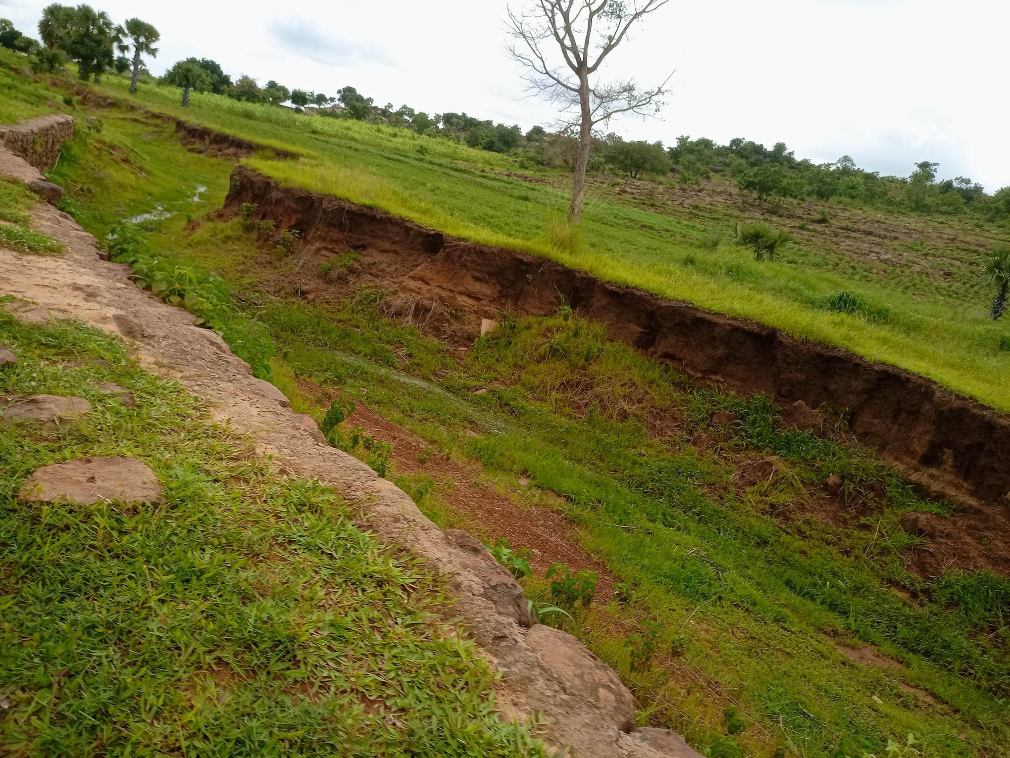
Green savanna grassland cut by a deep red-earth gully, with scattered trees and fan palms on the slope beyond

Kara & the North, Togo

Dapaong

Savanna country on the edge of Dapaong, in Togo's Savanes region. (AKOUETE Ata Franck / Wikimedia Commons · CC BY-SA 4.0)

The largest town of Togo's far north and capital of the Savanes region, set on rising ground in dry savanna near the Burkina Faso border. It is a Moba market town of millet fields, baobabs and rocky escarpments, with cave shelters and granaries in the cliffs nearby, and it serves as the administrative and trading centre for the driest and poorest part of the country.

Neighbourhoods

  • The centre and the market
    • First-time visitors
    • Markets
    • Close to transport

    The administrative core along the highway, with the market, the prefecture, banks, small hotels and the bush-taxi stands. Trade fills the streets on market days and the town is quiet for the rest of the week.

    Open in Maps
  • The mission quarter
    • Historic buildings
    • Quiet stays

    The area around the Catholic cathedral and the mission, whose schools, dispensary and guesthouse have shaped the town since the colonial period. Buildings here are plain and low, set among trees, and it is one of the calmer parts of Dapaong.

    Open in Maps
  • The outskirts and the fields
    • Local life
    • Walks

    Compounds of mud-brick and concrete houses spread out among millet and sorghum plots, baobabs and rock outcrops on every side of the town. The line between town and farmland is blurred, and life here follows the farming year.

    Open in Maps

Things to do

In the town

  • Dapaong marketmarket

    The region's main market, where millet, sorghum, shea butter, livestock, pottery and cloth are traded and sellers arrive from the surrounding villages and across the border.

    Open in Maps
  • The Catholic cathedral and missionlandmark

    The seat of the Dapaong diocese, with the mission buildings, schools and health work that have long been part of the town's life.

    Open in Maps

Rocks, caves and savanna

  • Nôk and Mamproug cave dwellingsattraction

    More than 300 shelters and granaries of clay, straw and stone built into cliffs and overhangs south of the town between the 17th and 19th centuries, largely for defence and for protecting harvests; they were placed on Togo's tentative list for UNESCO World Heritage in 2000.

    Open in Maps
  • Namoudjoga rock paintingsattraction

    Paintings of people, animals, horsemen and geometric signs on a large rock shelter in the Namoudjoga hills near Dapaong, one of several rock-art sites in the area.

    Open in Maps
  • The escarpment and savanna around the townviewpoint

    Low cliffs, rocky outcrops, baobabs and millet fields on the edge of town, green after the rains and bare and dusty through the Harmattan.

    Open in Maps

Short trips from the town

  • Cinkasséattraction

    A town about 38 km north of Dapaong on the borders with both Burkina Faso and Ghana, facing Cinkansé across the frontier and the main crossing for road freight in the far north.

    Open in Maps
  • Fosse aux Lions National Parkpark

    A national park of about 16.5 km² south of the town, first protected as a reserved forest in 1954, whose elephant population has fallen to almost nothing; the small town of Tandjouaré lies within it and facilities for visitors are limited.

    Open in Maps
  • Mangoattraction

    A town on the Oti river south of Dapaong on the highway, formerly Sansanné-Mango, the region's other main centre and a staging point on the road towards Kara.

    Open in Maps

Seasonal events

  • Market daysthroughout the year

    The town's set market days gather traders and farmers from across the Savanes region and from over the Burkinabè border.

  • The rainsMay to October

    The single wet season, when millet and sorghum are sown and the savanna turns green, and when work in the fields takes up most of the daylight.

  • Harmattan seasonDecember to February

    The dry, dusty months of Saharan wind, cool nights and very hot afternoons, when markets, funerals and ceremonies fill the calendar.

Eat and drink

Long-standing places and food districts in Dapaong. Hours, ratings and directions come from your maps app, always current.

Dapaong classics

  • Pâte and sauce at the marketmarket

    Cooked-food sellers serve pâte of millet, sorghum or maize with sauces of leaves, okra, baobab or groundnut, seasoned with fermented néré seeds.

    Open in Maps
  • Roadside grillsneighborhood

    Evening charcoal grills along the highway sell brochettes of goat and beef and sometimes guinea fowl, with chilli and onion.

    Open in Maps

Drinks and produce

  • Tchoukoutou courtyardsneighborhood

    Millet beer brewed by women and served warm in calabashes, drunk in compounds and at the market, and central to funerals and ceremonies.

    Open in Maps
  • Shea butter and bush producemarket

    Shea butter, néré seeds, baobab leaf powder and honey gathered from the bush are sold in the market, largely by women's groups.

    Open in Maps

Experience Dapaong

History

The land around Dapaong has been settled for a very long time: the cliffs and overhangs of the escarpments nearby hold shelters, walls and storage chambers built into the rock, used as refuges in times of raiding and as granaries safe from fire and animals, and they remain the clearest evidence of the region's older history. This is the country of the Moba and Gourma, farming peoples of the savanna who lived in dispersed compounds rather than towns, with authority held by earth priests and village elders.

The far north was the last part of Togoland brought under colonial control. German forces reached it at the end of the 19th century, and after the First World War the area passed to French administration, which established a post at Dapaong as the administrative centre for the savanna. Catholic missionaries followed, building the church, schools and a dispensary that grew into some of the region's main institutions, and Dapaong became the seat of a diocese.

After independence in 1960 the town became the capital of the Savanes region, and it grew slowly as an administrative and market centre, its economy shaped by the highway to Burkina Faso and by the cotton trade. Drought, thin soils and land pressure have driven migration south and abroad for generations. Since 2021 the region has been affected by attacks linked to the conflict in the Sahel, mainly in the prefecture on the Burkina Faso border, and a state of emergency was declared there in 2022.

Culture & Customs

Moba culture dominates the area, with Gourma communities alongside it and traders from elsewhere in Togo and from Burkina Faso in the town itself. Authority runs through lineage heads, earth priests and village chiefs, and land is held and allocated by families rather than bought and sold. Funerals are the largest gatherings of the year, lasting days, with drumming, dancing, tchoukoutou and the sacrifice of animals, and they bring migrants home from Lomé, Accra and Abidjan.

The region is known for carved wooden figures used in shrines and for the ceremonies that mark initiation, harvest and death; masked and stilt dances appear at festivals in the villages. Islam and Christianity are both strong — the town has mosques and a cathedral — and many households combine them with older practice without apparent difficulty.

The mission has been a cultural force in its own right, through schools, literacy work, health care and craft and farming co-operatives, and much of the region's educated class passed through it. Women's groups are unusually visible here, organised around shea butter, cereal banks and market trade. Market day is the social event of the week, and manners at it are formal: greetings first, bargaining slow, and elders served before anyone else.

Daily Life

Dapaong had 58,071 people at the 2010 census, which makes it the largest town of the Savanes region and, for most of its residents, a market and administrative centre rather than a city. Compounds spread widely between fields, and the built-up area gives way to millet, sorghum and baobabs within a few minutes' walk of the market.

Farming supports nearly everyone: millet, sorghum, maize, groundnuts and beans for the household, cotton as the cash crop, and goats, guinea fowl and cattle. Women gather and process shea nuts and néré seeds, brew beer and trade in the market. The rest of the town's work is administration, schools, health services, transport along the highway to Burkina Faso, and the aid and church organisations that have long operated in the region.

The year is sharply divided. From June the fields take all available labour; in the dry season people repair houses, hold funerals and ceremonies, and migrate south for seasonal work. The concerns are practical and severe: irregular rain, thin soils, water supply, food stocks between harvests, and the insecurity on the border, which has displaced families from villages and disrupted markets and farmland in the prefectures nearest Burkina Faso.

Food

Savanna food is grain and sauce. Pâte, a stiff dough of millet or sorghum flour and sometimes maize, is eaten at the main meals with sauces built on baobab leaf, okra, hibiscus leaf, groundnut or wild greens, seasoned with fermented néré seeds, whose dark, strong flavour is characteristic of the north. Meat is occasional rather than daily, most often goat or guinea fowl, and dried fish carried up from the rivers and the south gives depth to sauces.

Shea butter, made by pounding, roasting and boiling nuts gathered in the bush, is the common cooking fat and one of the region's few exports. Groundnuts are eaten roasted, ground into sauce or pressed for oil; beans appear as fried cakes; and yams and rice, both brought in from further south, are festival and market-day food rather than everyday fare. Wild foods matter here more than on the coast: baobab leaves and fruit, tamarind, néré pods and bush honey.

Tchoukoutou, the millet beer brewed by women and drunk warm from calabashes, is the social drink and part of every funeral, ceremony and market day; the courtyards where it is sold serve as the town's meeting places. In Muslim households, sweet millet drinks, bissap made from hibiscus and ginger juice take its place, and bottled lager is sold in the town's bars.

Planning tools

Budget

Dapaong is one of the cheapest towns in Togo. Accommodation is limited to a few simple hotels and the mission guesthouse, and market food costs very little. Transport is the main expense: the long highway journey from Kara or Lomé, and a hired vehicle or motorbike with a guide for anything outside the town.

Daily Budget Midrange
USD 55–110 (a simple hotel, restaurant meals, a hired vehicle with driver and a guide)
Daily Budget Shoestring
USD 20–40 (auberge or mission guesthouse, market food, bush taxis and zémidjans)

Cash machines are unreliable this far north, so money is best drawn in Kara, and fuel and water are worth carrying for any trip out of town.

Best Time to Visit

November to February is the coolest and driest time, though the Harmattan fills the air with dust. March to May is extremely hot, regularly above 35°C. The rains from June to September green the savanna and are the busiest months in the fields, with tracks outside the town often difficult.

Suggested Number of Days

A day covers the town and its market. A second allows the rock country nearby with a guide, or a stop on the way between Kara and the border. Distances, road conditions and the heat of the middle of the day are what stretch a visit here.

First Visit
1 day
With Surroundings
2 days

Transportation

The town is small enough to walk, and zémidjan motorbike taxis handle everything else, including the tracks out to the villages and the cliffs. Shared taxis, minibuses and long-distance coaches run south along the highway to Mango, Kandé and Kara and north to the Burkina Faso border at Cinkassé.

Highway journeys are best made by daylight and started early, and a guide and a motorbike are the usual way to reach the rock shelters.

Airport & Station Connections

Dapaong lies on Togo's main north–south highway, roughly 220 km north of Kara and about 640 km from Lomé, reached by long-distance coach, minibus or bush taxi; most travellers break the journey at Kara or Sokodé. The border with Burkina Faso at Cinkassé is about 38 km north, and the nearest airport is at Niamtougou, near Kara.

Walkability

The centre is compact and flat enough to cross on foot in a quarter of an hour, with the market, the mission and the transport stands close together. There is little shade, the heat is severe from late morning, and the outskirts and the rock country need a motorbike or a vehicle.

Safety

The Savanes region, in which Dapaong stands, has been affected by attacks linked to the conflict in the Sahel, mainly in Kpendjal prefecture on the Burkina Faso border, and a state of emergency declared there in June 2022 has been extended several times. Road accidents and malaria are risks throughout.

Travel in the Savanes region near the Burkina Faso border is best avoided, highway travel is best done only by day, and local advice should be sought before any trip outside the town. Check current official travel advice before travelling.

Climate

The driest and hottest part of Togo, with one rainy season and a long dry one. Rain falls from about May to October, and the months before it are fierce; the Harmattan brings dust and surprisingly cool nights from December to February.

Summer
the rains, about May to October: 23–33°C, humid, with heavy storms and green fields
Winter
the Harmattan, about December to February: 16–36°C, dry and dusty, with cool nights and hot afternoons

Local Customs

This is Moba and Gourma country, with Islam, Christianity and traditional practice all present, and French used in offices and schools. Chiefs and elders carry authority, and visits to villages, cliffs or granaries are arranged through them or a recognised guide, with a fee paid to the community. Dress is modest, greetings are unhurried and asked in order of seniority, and shrines and burial places are not entered without permission.

Permission is asked before photographing people, compounds, granaries or soldiers, and photography near the border and at checkpoints should be avoided entirely.

Common Payment Methods

The currency is the West African CFA franc, pegged to the euro. Dapaong has a few bank branches and cash machines but they cannot be relied on, and cards are effectively useless outside them. Everything is paid in cash, small notes are needed for transport and the market, and mobile money is widely used by residents.