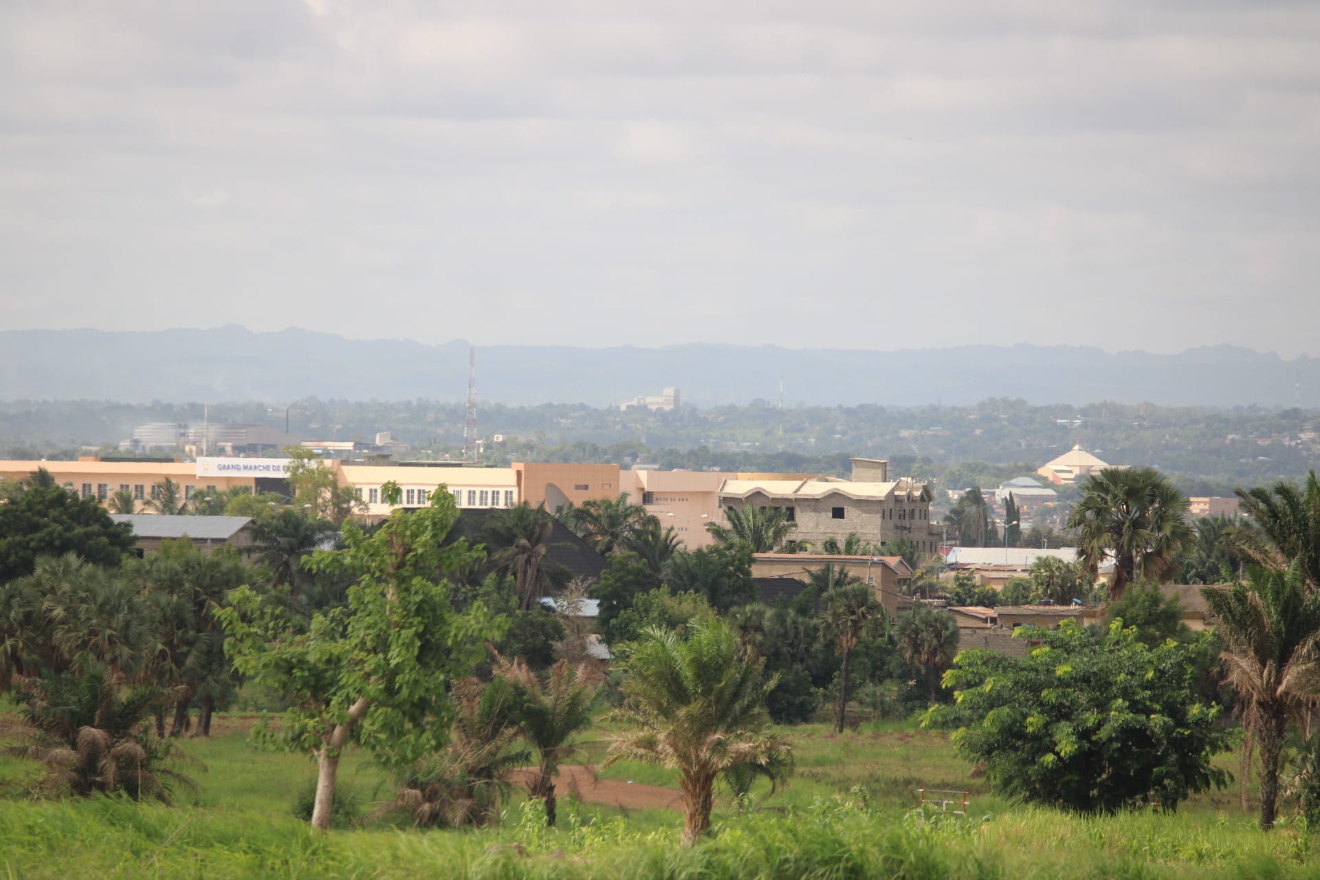
A low town of pale buildings and palms spreading towards a long hazy ridge of hills under a cloudy sky

Kara & the North, Togo

Kara

Kara seen across trees and fields, with the hills of northern Togo behind. (Hermannkass / Wikimedia Commons · CC BY-SA 4.0)

Northern Togo's main city, on the Kara river at the foot of the terraced Kabye hills, about 420 km up the highway from Lomé. A small colonial-era station, it grew quickly from the 1970s under a president born nearby, gaining a university, a stadium and wide boulevards, and now serves as the regional capital and the base for visits to the Koutammakou tower-houses.

Neighbourhoods

  • The centre and the market
    • First-time visitors
    • Markets
    • Close to transport

    The administrative heart of the city, laid out on wide boulevards around the market, the prefecture and the banks, with hotels, bus and bush-taxi stands and most of the restaurants. It is busiest in the early morning and towards dusk, and quiet under the midday sun.

    Open in Maps
  • The university quarter
    • Students and nightlife
    • Quiet and residential

    The area around the University of Kara, at the southern edge of the city, with student housing, cheap eating places, photocopy shops and bars. Term time gives this part of the city a younger and livelier feel than the rest.

    Open in Maps
  • The riverside
    • Local life
    • Walks

    The banks of the Kara river, which runs past the city and swells in the rains, used for washing, market gardening and sand digging. Bridges and low-lying ground here flood in the wettest weeks of the year.

    Open in Maps
  • The Kabye hills around the city
    • Villages
    • Views
    • Walks

    The steep, densely farmed country rising east and north of Kara, where stone-terraced fields, granaries and compounds of round houses cover the slopes. Villages here keep the forges, markets and ceremonies of Kabye life, and roads are narrow and unsurfaced.

    Open in Maps

Things to do

In the city

  • Kara marketmarket

    The city's main market, drawing sellers from the hills with grain, yams, shea butter, cloth and livestock, and busiest on its set days.

    Open in Maps
  • University of Karaattraction

    Togo's second university after Lomé, created by decree in 1999 and opened in 2004, whose campus and students shape the southern edge of the city.

    Open in Maps
  • The Kara riverattraction

    The river that gives the city its name, low and sandy through the dry season and fast and brown in the rains, with market gardens along its banks.

    Open in Maps
  • Stade Municipalattraction

    The city's 10,000-seat multi-use stadium, home ground of ASKO Kara and a setting for public gatherings in the north.

    Open in Maps
  • Kara Regional Museummuseum

    A museum opened in 1983 inside the Kara Congress Palace, showing farming and hunting tools, household objects, instruments, dress and ritual objects of the peoples of the region.

    Open in Maps

The Kabye hills

  • The terraced hill villagesviewpoint

    Stone-walled fields, granaries and round thatched houses on the slopes east of the city, farmed intensively for generations and walked with a local guide.

    Open in Maps
  • Village forges and marketsmarket

    Hill villages keep rotating market days and, in places, blacksmiths working iron by hand, a craft with deep roots in the north.

    Open in Maps

Short trips from the city

  • Koutammakouattraction

    The land of the Batammariba north of Kandé, a UNESCO World Heritage cultural landscape of two-storey takienta tower-houses built of earth, with granaries, shrines and fields around them.

    Open in Maps
  • Kandéattraction

    A small town on the highway north, the nearest town on the road into the Koutammakou.

    Open in Maps
  • Niamtougou International Airporttransit hub

    The airport for northern Togo, north of Kara near Niamtougou, used mainly by the air force and by government, chartered and private aircraft rather than scheduled flights.

    Open in Maps
  • Bafiloattraction

    A trading town south of Kara on the highway, known for its large mosque, its weaving, its wagasi cheese and the nearby Bafilo Falls.

    Open in Maps
  • Bassarattraction

    A town west of Kara that was once a centre of iron making and is now known as the yam capital of Togo, growing the Labaco variety preferred for fufu.

    Open in Maps

Seasonal events

  • EvalaJuly

    The Kabye initiation festival, when young men wrestle in a series of bouts marking their passage to adulthood, held in the villages around Kara over several days.

  • AkpemaJuly

    The Kabye rite for young women, held around the same weeks as the Evala, with processions, dress and ceremony in the hill villages.

  • Market daysthroughout the year

    Markets rotate between Kara and the surrounding villages on fixed days, and each brings traders, livestock and produce down from the hills.

  • Harmattan seasonDecember to February

    The dry months of dust and cool nights, when roads to the villages and the Koutammakou are at their most passable.

Eat and drink

Long-standing places and food districts in Kara. Hours, ratings and directions come from your maps app, always current.

Kara classics

  • Pâte and sauce at the marketmarket

    Cooked-food sellers serve pâte of maize, millet or sorghum with sauces of leaves, okra or groundnut, often seasoned with fermented néré seeds.

    Open in Maps
  • Roadside brochettes and grilled guinea fowlneighborhood

    Charcoal grills along the main road sell brochettes of beef or goat and, on good days, guinea fowl, with chilli and raw onion.

    Open in Maps

Drinks and markets

  • Tchoukoutou barsneighborhood

    Courtyards and stalls where millet or sorghum beer brewed by women is served warm from calabashes, the north's everyday social drink.

    Open in Maps
  • Kara market food stallsmarket

    Fried bean cakes, rice and beans, yam chips and fried dough sold from basins around the market from early morning.

    Open in Maps

Experience Kara

History

Kara sits where the highway north crosses the Kara river, beneath hills the Kabye have farmed intensively for centuries, terracing the slopes in stone and manuring them by hand to feed a dense population on thin soil. The hills were a refuge, defensible and awkward for outsiders, and the settlements on them long mattered more than anything on the plain below.

The town on the river is a colonial creation: a bridge thrown over the Kara by the German administration in 1902 marks its beginning, and under later French rule the place then known as Lama-Kara grew slowly as a market and staging point on the road north, at the crossing of the highway and the east–west route from Bassar towards Benin. Crowded hillsides pushed many Kabye into migration, first as forced labour on colonial plantations and roads in the south and later as voluntary migrants to Lomé and the cocoa country.

The city's transformation came after 1967, when Gnassingbé Eyadéma, a Kabye born at Pya nearby, took power. Kara was made the centre of the north: the highway was improved, ministries opened branches, a stadium, hotels and wide boulevards were built, and the surrounding villages received attention and investment. Kabye men were recruited in large numbers into the army. The pace of building slowed after the 1990s, and the city's buildings still carry the stamp of that era, but the university founded in the 2000s gave it a new role, and Kara remains the administrative and commercial capital of northern Togo.

Culture & Customs

Kara is the centre of Kabye country, and the Kabye mark the stages of life with public ceremony. The Evala, held each July, brings young men back from Lomé and abroad to wrestle in the villages in bouts watched by whole communities: the matches confirm passage into adulthood, and the reputations won at them last for years. The Akpema is the parallel rite for young women, with processions and formal dress. These are rites, held in the villages and organised by families and elders; visitors watch on sufferance and with permission.

Traditional religion remains strong alongside Christianity and Islam, expressed in ancestral shrines, sacrifices at planting and harvest, and the authority of elders and chiefs over land and disputes. The stone terraces, granaries and round houses of the hills are themselves cultural inheritance, maintained collectively.

The city is more mixed than the hills. Students from across the country, traders from Sokodé and Bafilo, soldiers and civil servants give it a wider mix of languages and faiths, with mosques and churches within a few streets of each other. Wrestling and football are the local passions, and evenings pass over tchoukoutou in courtyards, where a calabash is shared and passed rather than bought by the glass.

Daily Life

Kara had 94,878 people at the 2010 census and has grown since, making it one of the largest cities in Togo and the main centre of the north. It spreads low and wide along the highway and the river, with the market and administrative buildings at its core and farming villages beginning immediately beyond the last streets.

The economy is administration, trade and transport: the regional government, schools and hospital, the university, the market that gathers the produce of the hills, and the lorries and bush taxis working the highway to Burkina Faso. Farming underlies all of it — sorghum, millet, maize and yams, with cotton as the cash crop, shea nuts gathered by women, and cattle, goats and guinea fowl. Remittances from relatives in Lomé and abroad keep many households going.

The year follows the rains: intense work in the fields from May, and a dry season of markets, funerals, house repairs and ceremony. Days begin before six and pause in the afternoon heat. Poverty is deeper here than on the coast, jobs for graduates are scarce, water and power supply are uneven, and the insecurity further north has pushed displaced families and higher transport costs into the region.

Food

The staple is pâte, a stiff dough of sorghum, millet or maize flour, eaten with sauces of leaves, okra, groundnut or baobab, commonly seasoned with fermented néré seeds, a dark, pungent condiment used across the West African savanna. Yams, grown in quantity to the west around Bassar, are boiled, fried or pounded into fufu, and rice appears at celebrations and in roadside dishes.

Meat is eaten less often than on the coast but matters at festivals: guinea fowl, goat and beef are grilled over charcoal or stewed in sauce, and brochettes are sold at the roadside in the evening. Shea butter, made by women from nuts gathered in the bush, is the cooking fat of many villages, and dried fish from the rivers and from the south flavours sauces. Fried bean cakes, yam chips and rice with beans are the everyday street foods.

Tchoukoutou, the millet or sorghum beer brewed by women and served warm in calabashes, is the drink of the region and part of every ceremony, funeral and market day; in Muslim households and towns, sweet millet drinks, bissap made from hibiscus and ginger juice take its place. Bottled lager and sodabi, the palm spirit from the south, are sold in the city's bars.

Planning tools

Budget

Kara is cheap, with simple hotels and auberges in the centre and very inexpensive market food. The costs that matter are transport and guiding: the long ride up from Lomé, a vehicle with driver for the tower-house villages, and the fees paid to village guides and communities, which are fixed locally and go to the villages.

Daily Budget Midrange
USD 60–130 (a better hotel in the city, a hired car with driver, guided visits)
Daily Budget Shoestring
USD 20–45 (auberge, market food, bush taxis and zémidjans)

Cash machines thin out sharply north of the city, so enough cash for village fees and fuel is best drawn in Kara.

Best Time to Visit

November to February is the most comfortable and the easiest for the unsurfaced roads into the hills and the Koutammakou, though Harmattan dust dulls the light. March and April are extremely hot. The rains from May to October green the hills and fill the river but make tracks difficult; the Evala wrestling falls in July, in the middle of them.

Suggested Number of Days

A day or two covers the city and a walk in the nearby hills. Three or four are needed to include the villages further north with a vehicle and a guide, or to stay through part of the July festival season. Road conditions in the rains are what usually add time.

First Visit
1–2 days
With Surroundings
3–4 days

Transportation

Zémidjan motorbike taxis are the city's transport and reach the hill villages on tracks no car will manage. Shared taxis and minibuses run the highway south to Sokodé, Atakpamé and Lomé and north to Kandé, Mango and Dapaong from stands near the market. Cars with drivers are hired by the day for the tower-house country.

Highway travel is best done by daylight, and a motorbike or four-wheel drive with a local guide is the practical way to reach the villages after rain.

Airport & Station Connections

Kara lies on Togo's single main north–south highway, about 420 km from Lomé — a long day by bush taxi or minibus, commonly broken at Atakpamé or Sokodé. Niamtougou International Airport, north of the city, has no scheduled commercial flights, so arrivals are by road. Buses also run north towards the Burkina Faso border.

Walkability

The centre is flat and laid out on broad streets, and the market, hotels and transport stands are close enough to walk between, though the boulevards are wide and there is little shade in the middle of the day. Distances to the university and the outer quarters are better covered by motorbike taxi, and anything in the hills involves steep, rough tracks.

Safety

Kara and the surrounding Kabye hills are generally calm, and the usual risks are road accidents on the highway and on motorbikes, and petty theft in crowded places. The situation differs further north, where the Savanes region near the Burkina Faso border has been affected by attacks linked to the conflict in the Sahel. Malaria is present all year.

Avoid the Savanes region on the Burkina Faso border, travel only by day on the highway, and use local guides in the Koutammakou. Check current official travel advice before travelling.

Climate

A single rainy season, from about May to October, followed by a long dry season. The Harmattan brings dust and genuinely cool nights from December to February, and the weeks before the rains, in March and April, are the hottest of the year.

Summer
the rains, about May to October: 23–32°C, humid, with heavy storms, a green landscape and muddy tracks
Winter
the Harmattan, about December to February: 17–35°C, dusty and hazy, with cool nights and very hot afternoons

Local Customs

Kabye is the language of the region alongside French, and traditional authority and initiation still order village life. Visits to hill villages, forges, granaries or ceremonies are arranged through the chief or a recognised guide, and fees are community payments rather than tips. Evala wrestling is a rite of passage, not a show for visitors. Dress is modest, greetings are unhurried, and elders are addressed first.

Permission is asked before photographing people, houses, granaries or ceremonies, and a guide should be arranged locally rather than approaching a village unannounced.

Common Payment Methods

The currency is the West African CFA franc, pegged to the euro. Kara has bank branches and cash machines that take international cards, and it is the last reliable place for them on the way north. Cards are otherwise almost never accepted, village visits and transport are paid in cash, and mobile money is widely used by residents.