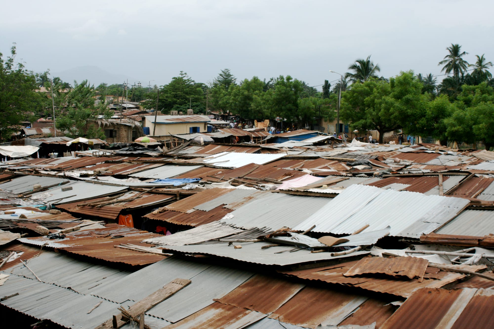
Rusting corrugated-iron roofs of a market spreading towards palms, trees and a hazy line of hills behind

Lomé, Kpalimé & the South, Togo

Kpalimé

The roofs of the main market at Kpalimé, with the hills of south-western Togo behind. (Dominik Schwarz / Wikimedia Commons · CC BY-SA 3.0)

A hill town in south-western Togo, close to the Ghanaian border and about 120 km from Lomé by road, set among the forested slopes of the Kloto uplands beneath Mount Agou, the country's highest peak. Coffee and cocoa brought it a German station and a railway from the coast; today its market, craft workshops and cool green surroundings make it the base for walking in the hills.

Neighbourhoods

  • The market quarter and town centre
    • First-time visitors
    • Markets
    • Close to transport

    The low centre around the main market, the church and the crossroads where the roads from Lomé, Atakpamé and the Ghanaian border meet. Shops, banks, small hotels, taxi and minibus stands and cooked-food sellers are all within a short walk, and the town is at its busiest here on market days.

    Open in Maps
  • The Kloto hills above the town
    • Walks and viewpoints
    • Quiet and residential
    • Nature

    The forested slopes north-west of the centre, reached by a winding road through cocoa and coffee plots, where villages such as Kouma-Konda sit among trees and butterflies. Air is cooler here, guesthouses are small and simple, and footpaths lead to viewpoints looking out over the plain into Ghana.

    Open in Maps
  • The Agou side
    • Hiking
    • Villages
    • Views

    The country south-east of the town around Mount Agou, a patchwork of hillside villages, terraced smallholdings and steep lanes rising to Togo's highest ground. It is farming country rather than a visitor district, and most people come for the climb and the views.

    Open in Maps

Things to do

Hills and waterfalls

  • Mount Agouviewpoint

    Togo's highest point, 986 metres, about 15 km south-east of the town, with villages and cocoa and coffee fields on its flanks, a paved road to the top and views that reach into Ghana.

    Open in Maps
  • The Kloto forest and Kouma-Kondatrail

    Remnant forest and farm paths in the hills north-west of the town, known for butterflies and birds, usually walked with a village guide.

    Open in Maps
  • Kpimé waterfallattraction

    One of several falls that drop from the plateau around the town, a short drive to the north, strongest late in the rains and much reduced in the dry months.

    Open in Maps
  • Château Vialelandmark

    A chateau of a main building and a tower built by a German in the early 1940s in the hills north of the town, near Kouma-Konda; owned by the state and used for cabinet meetings and visiting heads of state, it is known chiefly for its position on the ridge.

    Open in Maps

In town

  • The main marketmarket

    The town's produce and general market, busiest on its set days, selling yams, maize, peppers, cloth, palm oil and coffee and cocoa from the surrounding farms.

    Open in Maps
  • The craft workshopsattraction

    Kpalimé is Togo's main craft centre, with dozens of artisanal workshops and retail outlets and a training college, turning out batik, weaving, woodcarving, pottery, decorated calabashes and mounted butterflies.

    Open in Maps
  • The Catholic churchlandmark

    The town's large Catholic church, a landmark at the centre of Kpalimé and the seat of the diocese created in 1994.

    Open in Maps

Short trips from the town

  • The coffee and cocoa farmsattraction

    Smallholdings in the hills around the town where cocoa pods, coffee and spices are grown and dried, visited on guided walks from the villages.

    Open in Maps
  • The Ghanaian borderattraction

    The frontier about 15 km west of the town, where the hills continue into Ghana's Volta Region and cross-border trade fills the roadside markets.

    Open in Maps

Seasonal events

  • Market daysthroughout the year

    The town's set market days draw sellers and buyers from across the Kloto hills and fill the centre with traffic and produce.

  • The rains and the waterfallsApril to July, and September to October

    The wettest months, when the hills are greenest and the falls around the town run strongest, though tracks turn to mud.

  • Harmattan seasonDecember to February

    The dry, dusty months when Saharan haze softens the light over the hills and walking is at its most comfortable.

Eat and drink

Long-standing places and food districts in Kpalimé. Hours, ratings and directions come from your maps app, always current.

Kpalimé classics

  • Pâte and sauce at the marketmarket

    Cooked-food sellers in and around the market serve akoumé, the stiff maize dough, with adémè, gboma or groundnut sauce and a piece of fish.

    Open in Maps
  • Roadside grillsneighborhood

    Evening charcoal grills at the crossroads sell brochettes, grilled chicken and fried plantain, with beer and sodabi sold alongside.

    Open in Maps

Local produce

  • Hill coffee and cocoamarket

    Coffee and cocoa from the surrounding smallholdings are sold in the market, sometimes roasted or processed locally, along with honey and spices.

    Open in Maps

Experience Kpalimé

History

Kpalimé grew where the road from the coast meets the wooded escarpment of the Kloto hills, in Ewe country close to what is now the Ghanaian border. Its modern shape dates from the German colonial period, when the highlands were found to suit coffee and cocoa and the administration encouraged plantations on the slopes. The German commissioner Jesko von Puttkamer founded the first field station at Misahöhe, 9 km from the town, in 1890, and the Lomé–Kpalimé branch of the railway opened in 1907, making the town the collecting point for the crops of the hills.

The First World War brought the German period to an abrupt end. The frontier drawn after the war, and confirmed when British Togoland joined Ghana in 1957, cut the hills in two and left Kpalimé about 15 km from an international border, with families, markets and farmland on both sides. Under French administration and after independence in 1960, cocoa and coffee remained the basis of the local economy, with prices set far away and fortunes rising and falling with them.

The railway carried freight and passengers for decades before services ended, and the town turned to road transport. Craft work gave it a second reputation, for batik, weaving and woodcarving, and the forest, the waterfalls and Mount Agou drew the first visitors. Kpalimé today is a market and service town for a densely farmed upland, its population swollen by people who have left smaller villages.

Culture & Customs

The hills are Ewe country, with Akposso and Akébou communities on the higher ground to the north and east, and Ewe is the language of the market and the home while French belongs to school and administration. Traditional authority through village chiefs remains strong, and access to forest paths, waterfalls and farms is arranged through them or through guides they recognise, with fees agreed in advance and shared in the village.

Christianity is strong here, a legacy of the German and later missions, and churches are full on Sundays, with drumming and choirs audible across town. Vodun and older practice continue alongside it, quietly rather than publicly: sacred groves are left uncut, and shrines stand at the entrances to hamlets. Funerals are the great social events, gathering people back from Lomé and abroad, and bringing cloth, brass bands and all-night wakes.

Craft is the town's public identity. Kpalimé is Togo's main centre for wood sculpture, weaving, wickerwork, decorated calabashes, batik, pottery and mounted butterflies, with dozens of workshops and retail outlets and a training college for artisans; the workshops still take apprentices and sell to visitors. Market days set the town's weekly rhythm, drawing farmers down from the hills with head-loads of produce and filling the lorry park before dawn.

Daily Life

About 75,000 people live in Kpalimé, which makes it the fourth-largest town in Togo, after Lomé, Sokodé and Kara, and the main centre of the Kloto area. It is a place of low concrete and mud-brick houses under iron roofs, with the market, the lorry park and the church at its core and farmland beginning almost immediately beyond the last streets.

Farming underpins everything. Cocoa and coffee are the cash crops of the hills, grown on small family plots and sold through buyers in town; maize, cassava, yams, bananas, avocados and vegetables are grown for the household and the market. Trade with Ghana, legal and informal, is constant, and the craft workshops, transport, schools and a hospital provide most of the town's salaried work. Money sent home by relatives in Lomé and abroad matters to many families.

Days begin before dawn with the walk or motorbike ride to the fields, and the market fills early; the hottest hours are slow, and the evening belongs to the maquis and the football on television. Low and unpredictable crop prices, ageing plantations, soil erosion on steep slopes, patchy electricity and the loss of young people to Lomé and abroad are the standing concerns.

Food

Kpalimé eats what the south of Togo eats, with more of the hills in it. Akoumé, the stiff maize dough also called pâte, and fufu pounded from yam or cassava are the staples, eaten with sauces of adémè, made from jute leaves, gboma, a spinach-like green, okra, groundnut or palm nut, usually with smoked fish and sometimes with a little goat or chicken. Ayimolou, rice cooked with beans, is the common working breakfast, sold from great basins at the roadside.

The hills add their own produce: avocados, oranges, bananas and plantain grown between the cocoa trees, pineapple, and forest honey and spices sold in small bottles at the market. Yams from the plateau country to the north arrive by the lorry-load, boiled, fried or pounded. Grilled chicken and brochettes are the standard evening food at the roadside grills, often with fried plantain, alloco, or chips.

Coffee is the town's signature product, grown on the surrounding slopes, though most of the crop leaves the region unroasted and local drinking of it is modest. Palm wine is tapped in the lowlands and distilled into sodabi, drunk socially and poured in libation, and tchoukoutou, the millet beer of the north, turns up in bars alongside bottled lager, bissap made from hibiscus and fresh ginger juice.

Planning tools

Budget

Kpalimé is cheaper than the capital and is often used as a lower-cost, cooler base. Accommodation is mostly small hotels and simple guesthouses in town or in the hill villages, and market food costs very little. The main extras are guide fees for walks in the Kloto hills and on Mount Agou, and transport if a vehicle is hired rather than shared.

Daily Budget Midrange
USD 60–120 (a better hotel, restaurant meals, a hired car with driver and guide fees)
Daily Budget Shoestring
USD 20–45 (guesthouse or auberge, market food, bush taxis and zémidjans)

Guides for the hills are arranged in the villages or through guesthouses; agree the fee and the route before setting out.

Best Time to Visit

November to February gives the driest paths and the clearest walking, though Harmattan haze can flatten the views. The waterfalls are fullest late in the rains, in June and July and again in October, when the hills are at their greenest but tracks are slippery and leeches and mosquitoes are more active.

Suggested Number of Days

A day or two is enough for the town itself and one walk in the hills. Three suit a longer stay in the villages, with time for the farms and a full day of climbing. Rain, mud and the pace of shared transport are what usually stretch a visit.

First Visit
1–2 days
With Surroundings
3 days

Transportation

The town is small enough to cross on foot, and zémidjan motorbike taxis cover everything else, including the steep hill roads where cars struggle. Shared taxis and minibuses run to Lomé and to Atakpamé from stands near the market, and a vehicle with driver can be hired for the day to reach Mount Agou and the waterfalls.

Hill roads are steep, unsurfaced in places and slippery in the rains; allow much more time than the distance suggests.

Airport & Station Connections

Kpalimé lies about 120 km north of Lomé, generally three hours or so by road depending on traffic leaving the capital. Shared taxis and minibuses run the route through Kévé and Agou all day, starting early. The nearest airport is in Lomé. A colonial-era railway once linked the town to the capital, but passenger services no longer run.

Walkability

The centre is compact and flat enough to walk, with the market, church, transport stands and shops within a few minutes of each other. Pavements are patchy and the roadside is shared with motorbikes. Everything in the hills involves real climbing on unsurfaced tracks, best done early in the day before the heat.

Safety

Kpalimé and the surrounding hills are quiet, and the usual risks are road accidents, particularly on motorbikes, and petty theft in crowded market areas. Hill paths are steep and slippery in the rains, and walking with a local guide avoids getting lost on farm tracks. Malaria is present year-round, as across Togo.

Motorbike rides on the steep hill roads are the main everyday risk, hill paths are best walked with a village guide, and malaria precautions are needed all year. Check current official travel advice before travelling.

Climate

Wetter and a little cooler than the coast because of the altitude and the hills, with two rainy seasons and a break in August. Mornings in the Kloto uplands can feel genuinely fresh, and mist often sits in the valleys after rain.

Summer
the long rains, about April to July: 22–30°C, humid, with heavy afternoon storms and muddy tracks
Winter
the dry season, about November to March: 20–32°C, warm days and cooler nights, with Harmattan haze from December

Local Customs

French is the official language and Ewe is spoken everywhere; the hills around the town are Ewe and Akposso country. Visits to a village, a forest path or a farm go through the chief or a local guide, and the fee that is asked is a community arrangement rather than a tip. Dress is modest away from the guesthouses, greetings come before questions, and shrines and sacred groves should not be entered or photographed without permission.

Ask before photographing people, farms or shrines, and expect to pay a small agreed fee for guides and village visits rather than tipping afterwards.

Common Payment Methods

The currency is the West African CFA franc, pegged to the euro. Kpalimé has a few bank branches and cash machines in the centre, but they are not always reliable and cards are accepted almost nowhere. Village guides, guesthouses and the market work in cash, so it is worth arriving with enough, and mobile money is widely used locally.