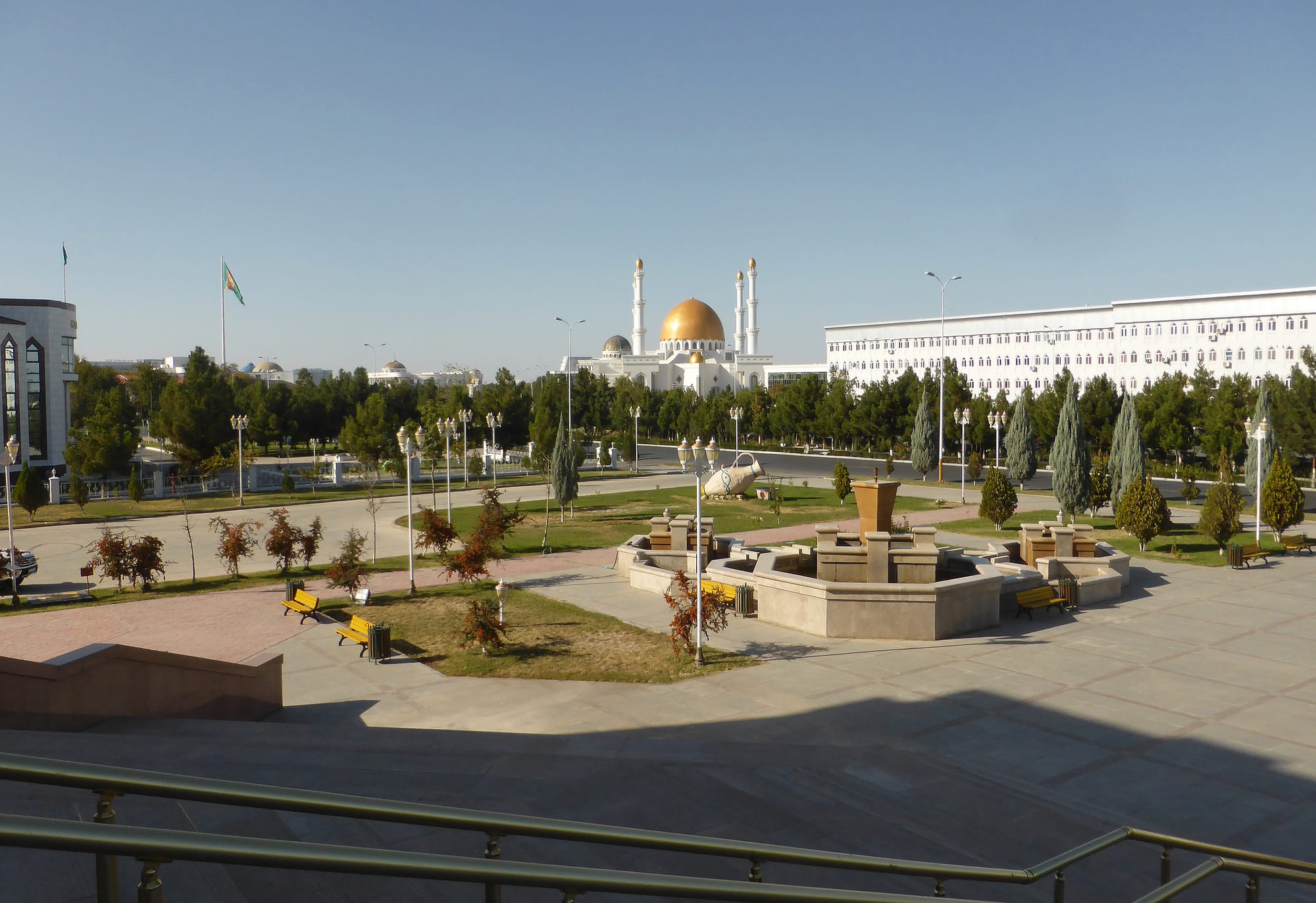
A wide city square with lawns, conifers and a fountain, backed by a white building and a mosque with a gold dome and white minarets

Mary, Merv & the East, Turkmenistan

Mary

A central square in Mary, with the city's gold-domed mosque behind. (Hans Birger Nilsen / Wikimedia Commons · CC BY 2.0)

An oasis city on the Murghab river in south-eastern Turkmenistan, founded by the Russians in 1884 a little west of the ruins of Merv, one of the great cities of the medieval Islamic world. Today it is a low, orderly provincial capital living on cotton, wheat and the gas fields of the surrounding desert, and the base for visiting Merv. This page is written to explain the city, not to encourage travel.

Neighbourhoods

  • The central squares
    • First-time visitors
    • Museums
    • Close to public transport

    The ceremonial heart of the city, with marble-faced public buildings, fountains, lawns and conifer planting around the main squares. The regional museum, the city mosque and most of the hotels used by visitors are within a short drive.

    Open in Maps
  • The Russian grid
    • Historic district
    • Walking

    The older streets laid out after 1884, low and tree-lined, with single-storey brick houses, shops and Soviet-era apartment blocks. This is where the shade is, and where daily errands are run on foot.

    Open in Maps
  • The bazaar quarter
    • Best for food
    • Local life
    • Markets

    The area around the main market, busiest in the early morning, where produce from the oasis, meat, bread and household goods are sold and shared taxis wait for passengers.

    Open in Maps
  • The river and the canal banks
    • Quiet and residential
    • Greenery

    Housing and allotments along the Murghab and the irrigation channels that cross the city, with poplars and willows on the banks and cotton fields beginning a short way out.

    Open in Maps
  • Bayramaly and the eastern oasis
    • Close to the ruins
    • Countryside

    A separate town about 30 kilometres east, at the edge of the Merv ruins, surrounded by irrigated farmland and long known as a climatic spa. The archaeological site begins immediately beyond it.

    Open in Maps

Things to do

Ancient Merv

  • Mervlandmark

    A UNESCO World Heritage Site about 30 kilometres east, where several walled cities of different eras stand side by side, from the circular citadel of Erk Kala and the square city of Gyaur Kala to the Seljuk capital beyond.

    Open in Maps
  • Tomb of Ahmad Sanjarlandmark

    The domed 12th-century mausoleum of the Seljuk sultan who ruled from Merv until 1157, the best-preserved building on the site.

    Open in Maps
  • Great Kyz Kalalandmark

    A large ruined köshk, an earthen palace-fortress whose outer walls are formed of massive corrugations, built between the Sasanian and early Islamic centuries and still in use under the Seljuks.

    Open in Maps

In the city

  • Mary Museummuseum

    The city's history museum, in the centre, covering the oasis from ancient times to the present through archaeological finds, carpets and displays on Turkmen life.

    Open in Maps
  • Gurbanguly Hajji Mosquelandmark

    The city's white marble mosque, completed in 2009, with gilded domes and four slender minarets, standing near the central squares.

    Open in Maps
  • Mary International Airporttransit hub

    The provincial airport about six kilometres north-east of the centre, with domestic flights from Ashgabat that most visitors use to reach the region.

    Open in Maps

Around the oasis

  • Bayramalyneighborhood

    A town about 30 kilometres east at the edge of the Merv ruins, in irrigated farmland, long known as a climatic spa whose sanatoria treat kidney and circulatory conditions.

    Open in Maps
  • Gonur Depelandmark

    A Bronze Age palace and temple complex excavated in the desert north of Mary, centre of what archaeologists call the Bactria–Margiana Archaeological Complex.

    Open in Maps
  • Hanhowuz Reservoirattraction

    A large reservoir storing Karakum Canal water west of the oasis, a rare expanse of open water in the desert.

    Open in Maps

Seasonal events

  • Nowruzlate March

    The spring new year, celebrated with family meals, music and the cooking of semeni from sprouted wheat.

  • Melon DayAugust

    A national holiday for the Turkmen melon, marked in a province famous for growing them.

  • The cotton harvestSeptember to November

    The busiest season in the oasis, when the fields, roads and gins around the city are working at full stretch.

  • Independence Daylate September

    The anniversary of independence in 1991, marked with concerts, decoration of the squares and public ceremony.

Eat and drink

Long-standing places and food districts in Mary. Hours, ratings and directions come from your maps app, always current.

Markets and food districts

  • The central bazaarmarket

    The city's main market, piled with melons and watermelons in late summer, and selling dried fruit, nuts, spices, rice, mutton and tandoor bread all year.

    Open in Maps
  • Tandoor bakeries and somsa stallsneighborhood

    Clay ovens across the older districts bake round chorek loaves and somsa, meat-and-onion pastries pressed to the oven wall.

    Open in Maps
  • Chaikhanas and restaurants near the centreneighborhood

    Tea houses and canteens around the central streets serving chorba, palow, manty, lagman and shashlik, with green tea throughout.

    Open in Maps
  • Roadside melon stalls in the oasismarket

    Stalls along the roads out of the city sell the melons the province is known for, along with grapes, pomegranates and tomatoes in season.

    Open in Maps

Experience Mary

History

Mary is a young city beside a very old one. The Murghab river, flowing north out of the Afghan mountains, spreads into an inland delta and has supported farming here since the Bronze Age, when Gonur Tepe and its neighbours flourished in what is now desert to the north. The oasis later became Margiana, a province of the Persian empire, and under Alexander's successors a walled city was founded at what became Merv, about 30 kilometres east of the modern centre.

Merv grew for more than a thousand years, each era building a new walled city beside the last: a Sasanian stronghold, the base from which Arab armies moved into Central Asia, and in the 11th and 12th centuries the eastern capital of the Seljuk empire and one of the largest cities in the world, with libraries, madrasas and an observatory associated with Omar Khayyam. Sultan Sanjar died in 1157 and was buried in the domed tomb that still stands. In 1221 the Mongols destroyed the city and killed much of its population, and though smaller towns followed on the site, it never recovered.

The modern city dates from the Russian conquest of the Merv oasis in 1884, when a garrison and administrative town were laid out west of the ruins on a grid, served by the Transcaspian Railway. In Soviet times it became a cotton centre, and from the 1960s the discovery of enormous gas fields in the surrounding desert changed the province's economy. Since independence the centre has been rebuilt with marble-faced public buildings, and in 2012 Mary was declared one of the cultural capitals of the Commonwealth of Independent States.

Culture & Customs

The Merv oasis is Teke Turkmen country, and its identity is bound up with the carpet patterns, dress and family networks of that group, which differ in detail from those of Ahal or the Amu Darya. Weaving is the household art: deep-red carpets with rows of güls, and the embroidered dresses and heavy silver jewellery worn by brides. Weddings are the great public occasions, with music, singing and long tables late into the night, and the wider family is expected to take part.

The ruins are not only an archaeological site to local people. Shrines within and around Merv draw pilgrims, who circle the tombs, pray and tie cloth to frames, and Sunday and holiday visits are as much devotional as touristic. The city's mosque and the smaller neighbourhood ones fill on Fridays, and religious practice is generally quiet and family-based.

Provincial life is formal in public and warm in private. Public ceremony — parades, anniversaries, decorated squares — follows the national pattern, and the city was given prominence as a cultural capital of the Commonwealth of Independent States in 2012. Hospitality is emphatic: tea is offered immediately and refusing food is awkward; elders are greeted and served first. Turkmen dominates daily speech, with Russian still heard among older and urban residents, and the oasis keeps a strong sense of being the country's agricultural heartland.

Daily Life

About 167,000 people live in Mary, the country's fourth-largest city and the capital of a province of well over a million. The city is flat and low-rise: Soviet apartment blocks and single-storey brick houses on the old grid, marble-faced offices around the central squares, and allotments and poplars along the irrigation channels. Most households shop at the bazaar in the early morning and travel by shared taxi or bus.

Two industries shape the province. The desert holds the Galkynyş field, the world's second-largest gas field, and the older Shatlyk field found in 1968, and gas processing, pipelines and the power station at the edge of the city provide skilled and rotational work. The oasis itself grows cotton, wheat, melons and vegetables on canal and river water, with state quotas and an autumn harvest that pulls in labour from across the region.

Days start early, particularly in summer, when outdoor work and errands are done before the heat and the streets empty in the afternoon. Water is the persistent worry: the Murghab's flow is shared with Afghanistan upstream, irrigation has left salt in the soil, and supply to households can be intermittent. Food prices and the gap between the official and informal value of the manat press on budgets, the internet is slow and heavily filtered, and many families have members working in Ashgabat or abroad.

Food

The Mary table is the Turkmen one, built on bread, mutton, rice and tea. Chorek, the round loaf baked against the wall of a clay tandoor, is on every table and treated with respect. Palow — rice cooked slowly with mutton, carrot and onion in a heavy pot — is the dish of guests, weddings and holidays. Dograma, regarded as the national dish, tears chorek into a bowl with boiled mutton and raw onion and is moistened with broth, and is associated with feasts and religious occasions. Chorba, a mutton and vegetable soup, is everyday food.

Bazaar and street food is shared with the wider region: somsa baked in the tandoor, gutap fried in thin half-moons with meat, pumpkin or greens, manty steamed in stacks, lagman noodles in broth, and shashlik grilled over charcoal wherever there is a crowd. Gatyk, a thick sour yoghurt, and suzma, its drained form, cool summer meals, and chal, fermented camel's milk, comes in from the desert in the hot months.

Fruit is what the province is known for. Turkmen melons from the Murghab oasis were famous across the Soviet Union and have their own national day in August; watermelons, grapes, apricots, pomegranates and tomatoes fill the market through the season, and much of the crop is dried for winter. Green tea, poured from small pots into bowls, is drunk all day and offered to every visitor, with black tea more common in the cold months.

Planning tools

Budget

Costs here are set by the guided tour rather than by the city. Mary is the usual overnight base for Merv, with a small number of state-priced hotels, and is reached by domestic flight or a long drive from Ashgabat. Local prices in manat are very low, but the guide, driver, hotels and permits are paid to the agency in advance in US dollars.

Daily Budget Midrange
USD 180–320 (full guided tour taking in Merv and Gonur Tepe, hotel, car and driver)
Daily Budget Shoestring
USD 120–180 (transit route with a guide, simple hotel, bazaar food and tea)

Bring clean, new US dollar notes for the whole trip; cards are not usable here and cash machines cannot be relied on.

Best Time to Visit

April to May and late September to October. The ruins are open and shadeless, so early morning and late afternoon are the workable hours even in spring. The cotton harvest fills the oasis with activity in autumn, midsummer regularly passes 40°C, and winter is cool, grey and occasionally frosty.

Suggested Number of Days

Most visits last a night or two, which is what the ruins east of the city usually require. Longer stays are for those adding a desert excursion north or a slower look at the oasis. Domestic flight times and the wider tour route generally decide the length of a stay.

First Visit
1–2 days
With Surroundings
2–3 days

Transportation

Visitors move by car with their guide, which is the practical way to reach the ruins and the oasis villages, since the archaeological site is large and distances inside it are long. The city itself has buses and shared taxis used by residents, and trains on the Ashgabat–Turkmenabat line stop at the station.

Keep the car for the ruins: walking between the separate walled cities of the site in the heat is not realistic.

Airport & Station Connections

Mary International Airport, about six kilometres north-east of the centre, has domestic flights from Ashgabat taking about an hour, which is how most visitors arrive. The main road and railway east from the capital also pass through, roughly six to seven hours by car, and continue to Turkmenabat and the Uzbek border crossing at Farap.

Walkability

The older grid of streets is flat, shaded by trees and easy to walk, and the central squares can be crossed on foot, though they are built to a monumental scale with long open stretches. The bazaar is the one place where walking is genuinely rewarding. The ruins outside the city need a vehicle, and summer heat limits walking to early and late in the day.

Safety

Crime against visitors is very low and guides accompany tours throughout. The practical hazards are extreme summer heat and dehydration at the unshaded ruins, uneven ground among the earthworks, long drives on rough roads, and the restrictions that apply everywhere in the country on photographing official buildings, police and checkpoints.

Carry water and sun protection at Merv, wear sturdy shoes on the earth walls, and ask the guide before photographing anything official. Check current official travel advice before travelling.

Climate

A hot desert climate in an irrigated oasis, among the hottest parts of the country in summer. Rainfall is low and concentrated in winter and spring, dusty desert winds blow through the oasis, and spring and autumn are short.

Summer
very hot and dry, often above 40°C by day with warm nights and blowing dust
Winter
cool, generally around 0–10°C by day, with frost at night and occasional snow

Local Customs

Mary is a conservative provincial city where dress is modest and neat, shoes are removed indoors and at mosques, and women cover their heads at religious sites. Guests are pressed to eat, tea is poured constantly, and bread is handled with care. Weddings are large public occasions, and the Teke carpet patterns and silver jewellery of the oasis are worn with pride at them.

Tipping is not customary beyond something for a guide or driver at the end of a tour; ask before photographing people, and keep clear of pilgrims at shrines within the ruins.

Common Payment Methods

The currency is the Turkmen manat, exchanged at a fixed official rate. This is a cash economy: international cards do not work, cash machines are scarce and often empty, and the tour is paid in US dollars arranged in advance. Small manat notes are useful at the bazaar and for tea houses.