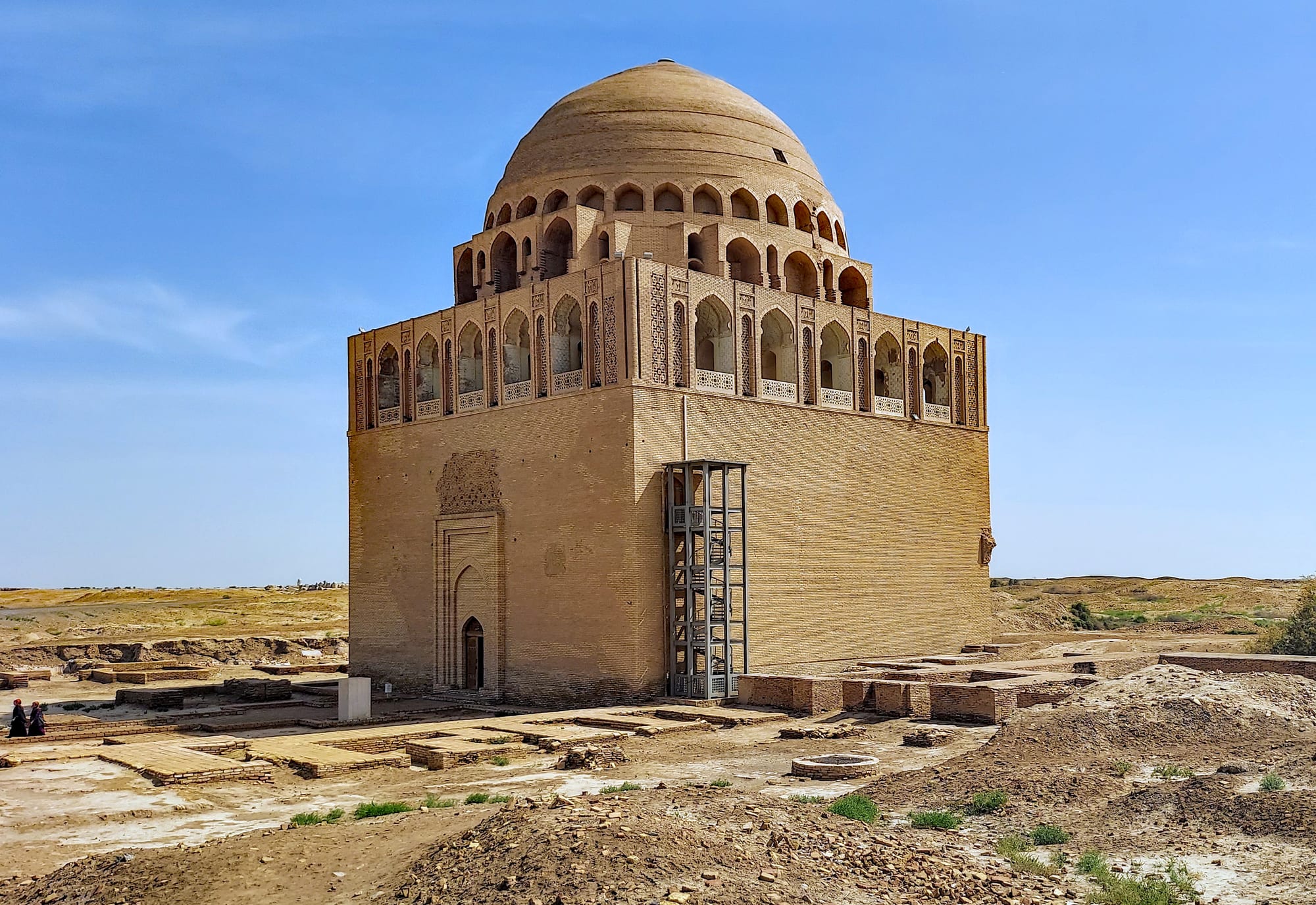
A square brick mausoleum with an arcaded gallery and a large ribbed dome, standing among low excavated ruins

Turkmenistan

Mary, Merv & the East

The 12th-century mausoleum of Sultan Sanjar in the ruins of ancient Merv, near Mary. (P. Hughes / Wikimedia Commons · CC BY 4.0)

Eastern Turkmenistan, from the Murghab oasis around Mary and the ruins of ancient Merv to Turkmenabat on the Amu Darya and the Koytendag mountains on the Uzbek border — a land of Bronze Age and Silk Road cities, cotton and gas fields, and the country's highest peaks.

Explore Mary, Merv & the East

History

The Murghab river fans out into an inland delta north of the Kopet Dag, and settled farmers used its water from the Bronze Age. Gonur Tepe, in the desert north of Mary, was a walled centre of what archaeologists call the Bactria– Margiana Archaeological Complex around 2000 BC, with palaces, fire altars and rich graves. Later the oasis was Margiana, a province of the Persian Empire, and under Alexander's successors a new walled city, Antiochia Margiana, rose at Merv.

Merv then grew for more than a thousand years, each new city built beside the last. It was a Sasanian stronghold, the base from which Arab armies advanced into Central Asia, and the city where the Abbasid revolt was launched in 747. Under the Seljuks in the 11th and 12th centuries it became their eastern capital and one of the largest cities in the world, with libraries and the observatory where Omar Khayyam is thought to have worked. Sultan Sanjar died in 1157, and in 1221 the Mongols destroyed the city and killed much of its population.

Along the Amu Darya, Amul, near today's Turkmenabat, was an important river crossing on the route from Merv to Bukhara, and the region long lay under the Emirate of Bukhara. The Russians took the Merv oasis in 1884 and founded Mary beside the old ruins, and in Soviet times both provinces became cotton lands watered by the Amu Darya and the Karakum Canal.

Culture & Customs

Mary and Lebap are home to different Turkmen tribes from Ahal. The Merv oasis is Teke country, while the Ersari live along the Amu Darya, and each group has its own carpet patterns, dress details and family networks. Lebap — the name means "riverbank" — has long ties to its Uzbek neighbours, and the local dialect of Turkmenabat blends Turkmen and Uzbek, reflecting centuries of rule from Bukhara.

Religious life centres on shrines as much as mosques. Merv was long a popular place of pilgrimage, and in Lebap the Astana Baba mausoleum near Kerki gives its name to the town that has grown up around it. Weddings remain the great public occasions, with music and singing late into the night.

Horses are prized here too, and the cotton harvest still shapes the autumn calendar.

Daily Life

Mary, the provincial capital, is a low, tidy city of broad streets and marble public buildings on the Murghab, and a centre of the gas and cotton industries. The province is the heart of the gas industry: the Galkynysh field, one of the world's largest gas fields, and the older Shatlyk field lie in its desert. Cotton, wheat and melons fill the irrigated land.

Turkmenabat, the old Chardzhou, is a river city and rail junction on the Amu Darya, with food-processing plants, textile mills and a busy bazaar, and is the second-largest city in the country. The rest of Lebap is a strip of irrigated farmland along the river between the Karakum on one side and the Uzbek border on the other, reaching south-east to the mountain villages of Koytendag.

Everyday life follows the national pattern — family, bazaar, state work — with the heavy demands of the cotton harvest each autumn.

Food

The eastern oases share the national dishes — palow, dograma, chorba and tandoor-baked chorek — and noodle dishes such as lagman, shared with neighbouring cuisines, are common in the bazaars of Turkmenabat. River fish, fried or grilled, is eaten along the Amu Darya.

Melons are the region's pride. Turkmen melons were famous across the Soviet Union, which the country once supplied, and in late summer the roadside stalls of Mary and Lebap are piled with them, alongside watermelons, grapes and pomegranates.

Green tea is drunk all day, and in the villages chal, fermented camel's milk, and gatyk, a thick yoghurt, cool the heat.

Attractions & Natural Wonders

Ancient Merv lies just east of Mary: the earthen ramparts of Erk Kala and Gyaur Kala, the walled Seljuk city of Sultan Kala with the domed mausoleum of Sultan Sanjar, and the Timurid-era Abdullah Khan Kala to the south. Scattered across the oasis are the corrugated mud-brick walls of the Great and Little Kyz Kala, early medieval fortified mansions, Mary is known for its regional museum, and the excavated palace and temples of Gonur Tepe lie a long 4x4 ride to the north.

In Lebap, Turkmenabat stands on the Amu Darya, whose green, braided channels contrast with the dunes of the Karakum. South of the city the Repetek reserve protects a patch of sand desert with saxaul trees, studied by scientists since the early 20th century, upstream near Kerki stands the Astana Baba mausoleum, and far downstream, north-west of Turkmenabat, the medieval caravanserai of Daýahatyn.

In the far south-east, the Koytendag range rises to Aýrybaba, the highest mountain in Turkmenistan. Its limestone country hides more than 300 caves, including the Karlyuk caves, and the dinosaur plateau near Hojapil, where hundreds of fossilised footprints cross a tilted rock slab.

Cities in Mary, Merv & the East

Planning basics

Budget

Mary is the usual overnight stop for Merv, with a handful of hotels at state prices, and is reached by domestic flight or a long road from Ashgabat. Koytendag is remote and needs extra driving days, a 4x4 and special permits, which make it one of the most expensive add-ons in the country. Local prices in TMT are low; tours are paid in US dollars.

Daily Budget Midrange
USD 180–320 (full guided tour with Merv and Gonur Tepe, or a 4x4 trip to Koytendag)
Daily Budget Shoestring
USD 120–180 (transit route via Mary and Turkmenabat with a guide, simple hotels)

Ask the agency early about Koytendag, as the border-zone permit takes extra time to arrange.

Safety

Crime is low and guides accompany tours. The main hazards are extreme summer heat at the ruins, long drives on uneven roads and, at Koytendag, mountain terrain and remoteness close to the Uzbek and Afghan borders, where movement is restricted and checkpoints are frequent.

Carry water and sun protection at Merv and Gonur Tepe, and keep passports and permits to hand near the borders. Check current official travel advice before travelling.

Climate

The Mary oasis and the Amu Darya valley are among the hottest parts of the country in summer, with dusty desert winds. Koytendag is the exception: its high plateaus and valleys are cooler and greener, and the peaks carry snow in winter.

Summer
very hot in Mary and Turkmenabat, often above 40°C; cooler in the Koytendag uplands
Winter
cool to cold, around 0–10°C in the lowlands; snow on the Koytendag peaks

Transportation

Mary has an airport with domestic flights from Ashgabat, and the main road and railway run east from the capital through Mary to Turkmenabat, where the Farap crossing leads to Bukhara in Uzbekistan. Merv is a short drive east of Mary, and Gonur Tepe is a long 4x4 drive across desert tracks. Koytendag lies far to the south-east of Turkmenabat along the Amu Darya.

Many travellers crossing to or from Uzbekistan use Turkmenabat and Farap, combining Merv with a transit route.

Best Time to Visit

April to May and late September to October. Merv's ruins are exposed and shadeless, so early morning or late afternoon visits suit even in spring. Late spring and autumn are best for walking in Koytendag, and the cotton harvest in autumn fills the oases with activity.