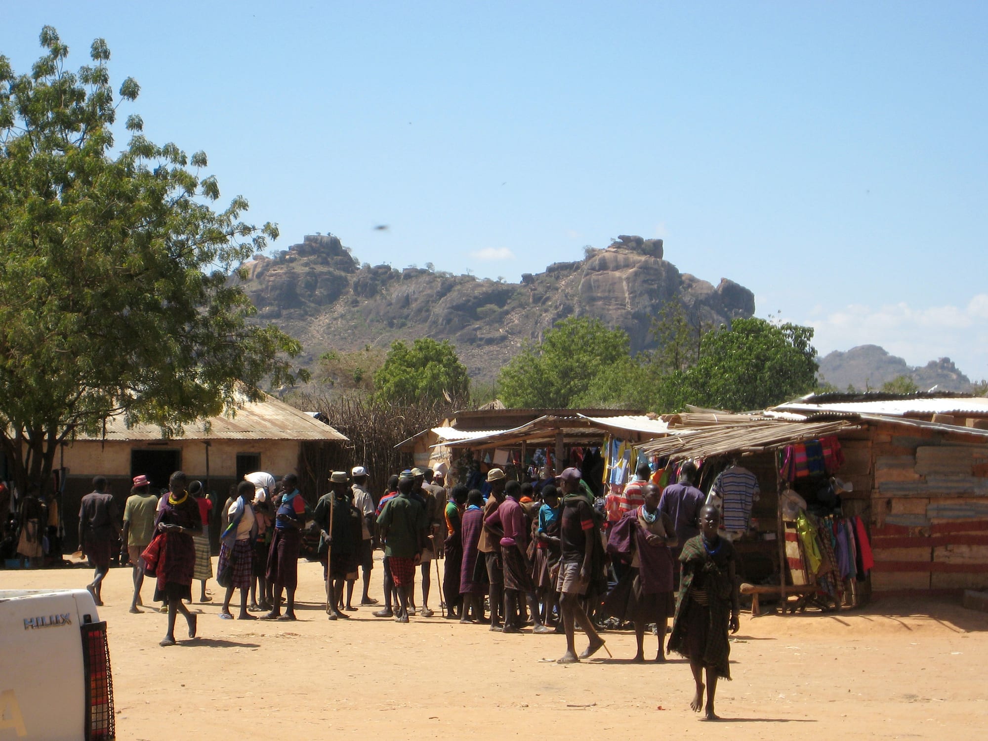
A dusty open square in a small town with corrugated-iron market stalls and people walking, rocky hills rising behind

Gulu, Kidepo & the North, Uganda

Kaabong

A street corner in Kaabong town, beneath the rocky hills of Karamoja. (Keitsist / Wikimedia Commons · CC BY-SA 3.0)

A small district town in the far north-east of Uganda, in the Karamoja sub-region near the borders with South Sudan and Kenya. Set among dry plains and rocky hills in the country of the Dodoth, it is a market and administrative centre for a herding population and the last town of any size on the road to Kidepo Valley National Park.

Neighbourhoods

  • The town centre and market
    • First-time visitors
    • Markets
    • Local life

    A short grid of dusty streets with shops in corrugated-iron rows, trading stores, boda-boda stands and the open market where grain, vegetables, sandals and cloth change hands. Almost everything a visitor uses in Kaabong — transport, supplies, telephone airtime — is within a few minutes' walk of here.

    Open in Maps
  • The administrative quarter
    • Quiet and residential
    • Services

    The district offices, hospital, schools and church and mission compounds stand a little apart from the trading streets, on wider plots shaded by trees. It is the quietest part of the town and where most of the guesthouses and aid-agency vehicles are found.

    Open in Maps
  • The outskirts and the herding country
    • Landscapes
    • Local life

    Beyond the last buildings the land opens into thorn scrub, sorghum gardens and scattered homesteads fenced with brushwood. Cattle and goats are driven out at dawn and back at dusk, and the rocky hills that ring the valley are visible from almost everywhere in town.

    Open in Maps

Things to do

In the town

  • Kaabong marketmarket

    The town's trading centre, busiest on market days, where herders and farmers from the surrounding hills sell grain, milk, vegetables, livestock and beadwork.

    Open in Maps

Short trips from the town

  • Kidepo Valley National Parkpark

    A remote national park of 1,442 square kilometres, a broad savanna of long grass and fan palms ringed by mountains, with elephants, giraffes, buffalo and lions in the Narus valley.

    Open in Maps
  • Mount Morungoleviewpoint

    A mountain in Kidepo Valley National Park, the country around it home to the Ik, one of Uganda's smallest ethnic groups, who farm and hunt in the hills.

    Open in Maps
  • Kotidoattraction

    The district town south of Kaabong on the Karamoja road, a trading centre of similar size for the herding communities around it.

    Open in Maps
  • Mount Morototrail

    A mountain of 3,083 metres rising above the town of Moroto, with long climbs to the summit ridge, a full day's drive south of Kaabong.

    Open in Maps

Eat and drink

Long-standing places and food districts in Kaabong. Hours, ratings and directions come from your maps app, always current.

Kaabong eating

  • The market food stallsmarket

    Cooked food is sold beside the produce — beans and boiled maize, sorghum and millet bread with a sauce of greens or groundnut, roasted maize in season and sweet tea.

    Open in Maps
  • The trading-street eating housesrestaurant

    Simple rooms behind the shopfronts serve the standard Ugandan plate — rice, posho, beans, greens and stewed goat or beef — with chapati and fried eggs in the mornings.

    Open in Maps
  • Grilled goat and roadside snacksrestaurant

    Goat meat grilled over charcoal is the meat of choice in Karamoja, sold by the piece at roadside braziers alongside chapati, samosas and roasted groundnuts.

    Open in Maps

Experience Kaabong

History

The valley around Kaabong has been herding country for centuries, held by the Dodoth, one of the Karamojong-speaking peoples who moved into the dry north-east from the north. Their year turned on moving cattle between wet-season homesteads and dry-season grazing, and on relations — trading, intermarrying, raiding — with the Jie to the south, the Turkana across the Kenyan border and the Toposa in what is now South Sudan.

Colonial administration reached Karamoja late and lightly. The sub-region was governed at a distance and with very little investment, so schools, clinics and roads arrived decades after they did elsewhere in Uganda. Kaabong grew as a small administrative and mission post, with a trading row of shops serving the surrounding homesteads.

Independence changed little at first. The spread of automatic rifles from the 1970s onwards made traditional cattle raiding far deadlier, and successive governments answered with disarmament campaigns conducted by the army, which were followed by periods of relative calm and by renewed raiding. Kaabong became the headquarters of its own district in the 2000s, when Karamoja's large districts were subdivided, bringing offices, staff and aid organisations to the town. Kidepo Valley, north-west of the town, had been gazetted as a national park in 1962, and the slow growth of tourism there has given Kaabong a second role as a stop on the road.

Culture & Customs

Kaabong is the centre of the Dodoth, who speak Ngakarimojong and share the cattle-centred culture of the wider Karamojong group. Wealth, marriage and standing are counted in animals, and the homestead — a cluster of huts and granaries inside a thorn or brushwood fence, known as a manyatta — is the basic social unit. Elders hold authority, decisions are made in gatherings of men under a tree, and age-sets order a man's life stages.

Dress and ornament are distinctive: bright wrapped cloth, stacked bead collars worn by women, and stools that double as headrests carried by men. Dance and song mark marriages, initiations and the return of herds, and traditional beliefs about rain and cattle persist alongside Catholic and Protestant missions, which have been present in the district for generations and run many of its schools.

On the Morungole range north-west of the town live the Ik, a small group with their own language who farm and hunt in the hills; they are among Uganda's least numerous peoples and a subject of long-standing outside interest. Across the district, relations between herding communities, government disarmament programmes and the spread of settled farming and mining are constant themes in local life. Visitors are uncommon enough to be noticed, and a greeting in Ngakarimojong is received warmly.

Daily Life

Kaabong is a small town of some thirteen thousand people, serving a district whose population lives mostly in scattered rural homesteads. The built-up area is a handful of streets: shops, a market, the district offices, a hospital, schools and church compounds, with guesthouses and the vehicles of aid agencies and government programmes among them.

The economy is livestock and subsistence farming. Cattle, goats and sheep are the store of wealth, and families plant sorghum, millet, maize and beans on gardens that depend entirely on rains that often fail. Karamoja is among the poorest parts of Uganda and suffers chronic food insecurity in the months before harvest, when markets, relief programmes and remittances carry households through. Minerals are dug by hand in parts of Karamoja, and charcoal burning and brewing bring in cash.

The day begins early, with animals driven out to graze and the market filling soon after, and slows in the heat of the afternoon. Water is fetched from boreholes and pumps, power comes from solar panels and generators more than from the grid, and telephone coverage is patchy outside the town. Long distances to services, the effects of drought, and the security of roads and grazing areas are the issues people talk about most.

Food

Karamoja eats what the dry country and the herds provide. The staple is a stiff bread or porridge of sorghum or millet flour, cooked to the consistency of thick dough and eaten with the hands, dipped in a sauce of greens, beans or groundnut paste. Maize has become common through markets and relief supplies, and boiled or roasted maize and cassava fill out the day.

Milk is central to herding households, taken fresh or soured, and goat is the meat most often eaten, grilled over charcoal or stewed with onion and tomato. Meat is not everyday food for most families; it belongs to market days, ceremonies and the killing of an animal for a guest. Wild greens gathered in the bush, groundnuts, cowpeas and pumpkins broaden the plate in the wet season.

In the town itself the cooking is the standard Ugandan one: rice, posho, beans, greens, stewed meat and chapati, with the rolex — a chapati rolled around a fried egg — sold at roadside stalls, and sweet milky tea drunk through the day. Local brewing matters socially: beers made from fermented sorghum or millet are shared at gatherings, and distilled spirits are sold cheaply in the trading centres, where drinking is a recognised social problem.

Planning tools

Budget

The town itself is inexpensive: guesthouses are simple, meals are local, and there is little to spend money on beyond food, fuel and airtime. The real cost of a visit to this corner of Uganda is the journey and the park — a hired 4x4 with a driver, fuel for very long distances, Kidepo's entry and vehicle fees, and lodges inside or beside the park.

Daily Budget Midrange
USD 160–390 on safari (lodge, park fees, 4x4 with driver-guide)
Daily Budget Shoestring
USD 20–40 (a simple guesthouse in town, local meals, shared transport; no park fees)

Carry enough cash shillings and fuel for several days, as both are scarce in the far north-east, and arrange a Kidepo visit through an established operator.

Best Time to Visit

December to March is the driest and best time for the tracks and for wildlife in Kidepo, when the grass is short and animals gather near water, though it is also the hottest and dustiest part of the year. The rains from about April to October bring green country and better photography but rough, sometimes impassable roads.

Suggested Number of Days

The town takes a few hours to see, so most visitors stay a night on the way to or from Kidepo. Three or four days allows for the drive, time in the park and a visit to a Karamojong or Ik community. Road conditions and the long approach are what change the number.

First Visit
1 day
With Surroundings
3–4 days

Transportation

There is no public transport worth planning around. A few buses and shared minibuses link Kaabong with Kotido, Moroto and Kitgum on rough murram roads, running on their own schedules, and boda-boda motorbikes serve the town and nearby villages. Almost all visitors arrive in a hired 4x4 with a driver, which is also what the park tracks require.

Check the state of the roads and the security situation locally before setting out, travel between towns in daylight, and carry spare fuel, water and a tyre repair kit.

Airport & Station Connections

Kaabong lies about 540 kilometres from Kampala by road, a journey of two days or one very long one, usually through Gulu and Kitgum or up through Karamoja by way of Moroto and Kotido. The final stretches are unpaved. Kidepo Airport at Lomej, near the national park headquarters, takes daily flights from Entebbe, which is how many safari visitors reach the area.

Walkability

The town is small enough to cross on foot in fifteen or twenty minutes, and the market, shops and district offices are all within that circle. Streets are unpaved, dusty in the dry months and muddy in the rains, and there is little shade at midday. Anything outside the town needs a vehicle.

Safety

Karamoja is different: armed cattle raiding between communities, and attacks on vehicles on some roads, persist despite repeated army disarmament campaigns, and governments advise against travel to parts of the sub-region. The situation varies from district to district and from year to year, and the border areas with South Sudan and Kenya see spillover insecurity. In the town itself the everyday risks are road accidents, petty theft and the heat.

Take local advice on routes before any road journey in Karamoja, travel with an established operator and in daylight, follow police and ranger guidance, and take malaria precautions. Check current official travel advice before travelling.

Climate

Semi-arid and hot, with a single unreliable wet season from about April to October and a long dry season in between. Rainfall is lower and less dependable than in the rest of Uganda, and droughts are frequent; the hills around the valley are a little cooler than the open plains.

Summer
June to August is the wetter part of the year, green and about 18–30°C, with storms that cut the murram roads
Winter
December to March is hot and very dry, often above 32°C by afternoon, with dust, haze and bush fires

Local Customs

This is a herding society in which cattle carry wealth, marriage payments and standing, and questions about a family's animals are not casual conversation. Greetings come before business, elders are addressed first, and modest dress is expected of visitors. Ngakarimojong is the language of daily life, with English and some Swahili in offices and shops. Tipping is not customary, though guides and drivers appreciate it.

Always ask before photographing people, homesteads or livestock, and expect a payment to be requested; do not photograph soldiers, police or army posts, and enter a manyatta only with an invitation or a local guide.

Common Payment Methods

The Ugandan shilling is used for everything. Cash is essential: card payment is not accepted in the town, ATMs are few and unreliable this far from the larger centres, and mobile money agents are the usual way of moving funds. Bring enough shillings from Gulu, Moroto or Kampala to cover the whole trip, including fuel.