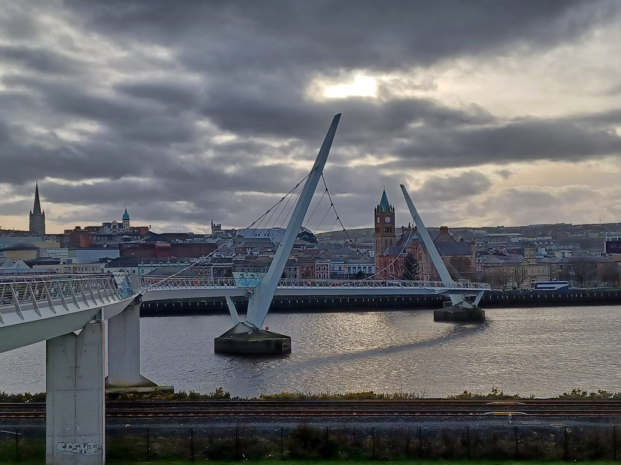
A curving white footbridge with two tilted masts over the River Foyle, with a red clock tower and a church spire behind under cloud

Northern Ireland, United Kingdom

Derry

The Peace Bridge across the River Foyle, with the Guildhall and the city behind. (Simon Burchell / Wikimedia Commons · CC BY-SA 4.0)

Northern Ireland's second city, officially Londonderry, on both banks of the River Foyle beside the border with County Donegal. It grew from a 6th-century monastery into a planned 17th-century walled city that never fell to siege, and later became a starting point of the Troubles. Today its intact walls, the Bogside murals and the Peace Bridge draw visitors to a compact, hilly city.

Neighbourhoods

  • The walled city
    • First-time visitors
    • Historic district
    • Close to public transport

    The hilltop inner city ringed by walls just under a mile round, running from the Guildhall up to St Columb's Cathedral. Its four original gates, steep streets, churches and the Craft Village sit within a short walk, and the walkway on top of the walls looks out over the whole city.

    Open in Maps
  • The Bogside
    • Murals and recent history
    • Museums

    A low-lying district just outside the walls on what was once a dried-up branch of the river. Its gable-end murals, Free Derry Corner and the Museum of Free Derry tell the story of the civil rights era, Free Derry and Bloody Sunday, and it is a short walk from the centre.

    Open in Maps
  • Waterside
    • Railway station
    • Quiet and residential

    The half of the city on the east bank of the Foyle, linked to the Cityside by the Craigavon Bridge, the Foyle Bridge and the Peace Bridge. The railway station, Ebrington Square and large residential districts and retail parks are here.

    Open in Maps
  • Cityside and the quays
    • Shopping
    • Nightlife

    The busy streets and riverfront north and south of the walls on the west bank, with the Foyleside and Quayside shopping centres and Waterloo Street, the main strip of bars, just north of the walls.

    Open in Maps

Things to do

The walls and the old city

  • Walls of Derrylandmark

    Built in 1613–1619, the only completely intact city walls in Ireland, just under a mile round and mostly over 4 metres high, never breached despite three 17th-century sieges, with a walkway on top.

    Open in Maps
  • The Guildhalllandmark

    The Guildhall at the foot of the walled city, completed in 1890 and rebuilt after a fire in 1912, with a clock tower modelled on the Elizabeth Tower in London.

    Open in Maps
  • St Columb's Cathedrallandmark

    The Church of Ireland cathedral of the Diocese of Derry and Raphoe, dedicated to St Columba, on the crag at the top of the walled city.

    Open in Maps
  • Apprentice Boys Memorial Hallmuseum

    The hall of the Apprentice Boys of Derry on Society Street, home to the Siege Museum, which tells the story of the Apprentice Boys and the Siege of 1689.

    Open in Maps

The Bogside and recent history

  • Museum of Free Derrymuseum

    A museum in the Bogside on the civil rights movement of the late 1960s and the Free Derry movement of the early 1970s, with photographs, posters, film footage and personal artefacts.

    Open in Maps
  • Free Derry Cornerlandmark

    A free-standing gable wall at the junction of Lecky Road, Rossville Street and Fahan Street, commemorating Free Derry, the self-declared nationalist area that existed between 1969 and 1972.

    Open in Maps
  • St Eugene's Cathedrallandmark

    The Roman Catholic cathedral of the Diocese of Derry, opened in 1873 and completed in 1903.

    Open in Maps
  • Long Tower Churchlandmark

    A church, also known as St Columba's, on the hill as Lecky Road climbs east out of the Bogside.

    Open in Maps

The river

  • Peace Bridgelandmark

    A curving footbridge opened in 2011 between the Foyle Embankment on the Cityside and Ebrington Square on the Waterside.

    Open in Maps
  • Ebrington Squareattraction

    A public square on the former army parade ground of Ebrington Barracks, opened in 2012 at the Waterside end of the Peace Bridge.

    Open in Maps
  • Craigavon Bridgelandmark

    One of only a few double-decker road bridges in Europe, crossing the Foyle and named after Lord Craigavon, the first Prime Minister of Northern Ireland.

    Open in Maps

Music, theatre and nights out

  • Millennium Forumattraction

    A theatre and conference centre on Newmarket Street with the city's largest auditorium, staging music, theatre and pantomime.

    Open in Maps
  • Waterloo Streetneighborhood

    A steep street just north of the walls that is the city's main strip of bars, several with traditional music.

    Open in Maps

Short trips from the city

  • Mussenden Templelandmark

    A small circular building on cliffs near Castlerock, high above the Atlantic on the north-western coast of Northern Ireland.

    Open in Maps
  • Giant's Causewayattraction

    Tens of thousands of interlocking basalt columns stepping into the sea on the north Antrim coast, a UNESCO World Heritage Site, reached from Derry by train to Coleraine and a bus along the Antrim coast.

    Open in Maps

Seasonal events

  • St Patrick's Day17 March

    A public holiday in Northern Ireland, marked in the city with parades.

  • City of Derry Jazz Festivallate April to early May

    A festival of jazz and big-band music in venues across the city.

  • Foyle Maritime FestivalJuly

    Tall ships, clipper races and events along the quays of the Foyle.

  • Maiden City FestivalAugust

    A week-long festival around the Apprentice Boys' Relief of Derry parade, which marks the lifting of the siege in 1689.

  • Halloween Carnivallast weekend of October

    A Halloween street carnival drawing more than 30,000 revellers, billed locally as the largest street party in Ireland and held over the weekend when the clocks change.

  • Foyle Film Festivallate November

    A film festival held over the last two weeks of November.

Eat and drink

Long-standing places and food districts in Derry. Hours, ratings and directions come from your maps app, always current.

Derry classics

  • Waterloo Street pubsneighborhood

    The city's main bar strip, just outside the walls, where traditional music sessions are part of the night.

    Open in Maps
  • Chip shops for a pastie supperneighborhood

    Northern Irish chip shops sell the pastie, a battered, deep-fried round of minced pork, onion and potato, served with chips as a pastie supper.

    Open in Maps

Food districts and markets

  • Walled City Marketmarket

    A market held in Guildhall Square on the first Saturday of the month.

    Open in Maps
  • Shipquay Street and the walled cityneighborhood

    Cafés and restaurants on the steep streets inside the walls, Thai food on Shipquay Street among them.

    Open in Maps

Experience Derry

History

The earliest records of the place date from the 6th century, when Colmcille, or St Columba, founded a monastery on the west bank of the Foyle at a place then called Doire Calgach; 546 is often given as the founding date, and the name Doire means "oak grove". The north-west stayed under Gaelic rule until the Nine Years' War, and in 1608 the town was burned in a rebellion. Under the Plantation of Ulster the English Crown handed the area to The Honourable The Irish Society, backed by the London livery companies, which built the first planned city in Ireland from 1613, enclosed it with walls by 1619 and renamed it Londonderry.

The walls withstood three sieges in the 17th century. In December 1688 apprentice boys shut the gates against King James's army, and the Siege of Derry lasted 105 days until relief ships broke through up the Foyle at the end of July 1689; the city has been called the Maiden City ever since. In the 19th century shirt-making, begun in 1831, became within 50 years the most prolific in the UK, with women often the main wage earners while unemployment among men was high.

Partition in 1921 put a border at the city's western edge. Catholics were discriminated against under unionist rule, and the city became the centre of the civil rights movement. The Battle of the Bogside in August 1969 is often dated as the start of the Troubles, and on 30 January 1972, Bloody Sunday, British paratroopers shot dead 13 unarmed civilians on a civil rights march. After the Good Friday Agreement of 1998 the Peace Bridge opened in 2011, and in 2013 the city was the first UK City of Culture.

Culture & Customs

Derry carries two names and two traditions. Nationalists say Derry, the name used by the council since 1984; unionists often prefer Londonderry, the official name under the royal charter of 1662; and the compromise "Derry/Londonderry" earned the city the nickname Stroke City from the broadcaster Gerry Anderson. Road signs in Northern Ireland read Londonderry, and on some of them "London" has been obscured. The Apprentice Boys of Derry commemorate the siege each August, while the Bogside's murals and the Museum of Free Derry tell the nationalist story of the civil rights years, Free Derry and Bloody Sunday.

The city has turned its calendar into a draw. Its Halloween carnival, held on the last weekend of October, draws more than 30,000 revellers and is promoted as the first and longest-running in Ireland, and there are jazz, maritime and film festivals through the year. The Millennium Forum and the Playhouse stage theatre and music, and traditional sessions fill the bars of Waterloo Street.

Both association football and Gaelic football are popular. Derry City, known as the Candystripes, play in the League of Ireland Premier Division, the top league of the Republic of Ireland, as its only club from Northern Ireland. Local humour is quick and self-mocking: residents once joked that the skeleton on the city's coat of arms was a Catholic waiting for a job and a council house.

Daily Life

The 2021 census counted about 85,000 people in the city, making it Northern Ireland's second-largest, and about 105,000 lived in the urban area in 2011. Around 78 per cent of residents in 2021 came from a Catholic background and about 17 per cent from a Protestant or other Christian one. The city divides along the river: about 17,000 Protestants lived on the west bank, the Cityside, in 1971, but the number fell rapidly during the 1970s, and the 2011 census recorded about 3,200 there against about 55,000 Catholics.

The old shirt factories have gone. Call centres and inward investment have filled part of the gap; Seagate has run a factory in the Springtown Industrial Estate since 1993 and employed about 1,400 people in 2019. The Magee campus of Ulster University is in the city, and critics have long argued that the north-west has been short-changed on investment, from the university to roads and railways.

Shopping centres such as Foyleside and Quayside serve the Cityside, and the Crescent Link retail park in the Waterside is the second largest in Northern Ireland. Life runs across the border as a matter of course, with hourly buses to Letterkenny and Buncrana in Donegal and cross-border shopping whenever exchange rates or tax differences favour it.

Food

Derry eats as the rest of Northern Ireland does. The Ulster fry, which topped a poll of Ulster's favourite dish, is a variant of the full breakfast that traditionally includes soda farls — farls made from soda bread — and potato bread alongside bacon, sausages and eggs. Champ is an Irish dish of mashed potatoes with scallions, butter and milk.

Chip shops are part of everyday life. Alongside fish and chips they sell the pastie, a round of minced pork, onion and potato in batter, deep-fried; with chips it is a pastie supper, because "supper" in a Northern Irish chip shop means something served with chips. In a white roll it becomes a pastie bap. The filling was traditionally coloured pink with cochineal, though many shops have stopped.

The walled city has cafés and restaurants on its steep streets, Thai among them, and the Craft Village inside the walls holds more. On the first Saturday of each month the Walled City Market is held in Guildhall Square. In the evening the bars of Waterloo Street, just outside the walls, are where food gives way to drink and music.

Planning tools

Budget

Walking the walls and the Bogside murals costs nothing, and the city is compact enough to need few taxis. Rooms are scarcer and dearer during the big festivals, above all the Halloween carnival, and paid museums and tours are the main extra costs.

Daily Budget Midrange
USD 150–260 (mid-range hotel or B&B, restaurant dinners, museums and a guided tour)
Daily Budget Shoestring
USD 60–100 (hostel bed, cafés and chip-shop suppers, walking)

Book rooms early for the Halloween carnival and other festival weekends.

Best Time to Visit

May to September for the longest days and the best walking weather. The calendar sets the tone: the jazz festival in spring, the maritime festival in July, the Maiden City Festival and Apprentice Boys parade in August, and the Halloween carnival at the end of October, which fills the city. Winter is damp and dark early, but quiet.

Suggested Number of Days

One or two days cover the walled city, the Bogside and the riverfront. Three or four allow time for the north coast and Donegal, which are much easier by car than by public transport.

First Visit
1–2 days
With Surroundings
3–4 days

Transportation

The city is compact, and most visitors walk; an hourly bus connects the Waterside station with the centre. Hourly buses run to Strabane, Omagh, Coleraine, Letterkenny and Buncrana, and up to twelve a day to Dublin. A car is needed for the countryside on both sides of the border.

From the Waterside station the city centre is a walk across the Craigavon Bridge or the Peace Bridge.

Airport & Station Connections

City of Derry Airport, near Eglinton on the south shore of Lough Foyle, is about 8 miles from the city centre, with flights to Glasgow, Edinburgh, Manchester, Liverpool and London Heathrow. Belfast's two airports and Dublin are alternatives. Trains run to Belfast via Coleraine and Antrim from the station in the Waterside, and buses link the city with Belfast, Dublin and Donegal.

Walkability

Compact and walkable, though some streets are steep. The walls form a walkway around the inner city, the Bogside is a short walk below them, and the Peace Bridge and Craigavon Bridge make the Waterside and the railway station a walk across the river.

Safety

The UK is generally safe, with the main risks being pickpocketing and phone theft in crowded parts of London and other cities, occasional late-night antisocial behaviour, and drink-related trouble around nightlife. In Derry the Bogside, a short walk from the centre, is generally considered safe to visit in daylight, and afternoon parades in the summer marching season can bring alcohol-fuelled disorder.

Treat murals and memorials respectfully, avoid contentious parades and bonfires in summer, and keep to well-lit streets late at night. Check current official travel advice before travelling.

Climate

Mild, damp and changeable. At Ballykelly, east of the city, at least a millimetre of rain falls on about 170 days a year, and frost comes on about 27 nights.

Summer
mild, with long evenings and frequent showers — in Belfast average daytime highs are about 17.5°C in July
Winter
cool and damp, with occasional frost — in Belfast average daytime highs are about 6.5°C in January

Local Customs

The city's name is itself a matter of identity: Derry is preferred by nationalists and used in everyday conversation by most residents, Londonderry is the official name and is preferred by many unionists, and both appear on signs and services. It helps to listen before talking politics.

Ask before photographing residents in the Bogside and other neighbourhoods, and treat memorials to the dead of the Troubles with respect.

Common Payment Methods

The currency is the pound sterling, and Visa and Mastercard debit and credit cards are accepted. Across the border in Donegal the currency is the euro. Northern Irish banks print their own notes, which are often not accepted in Great Britain.