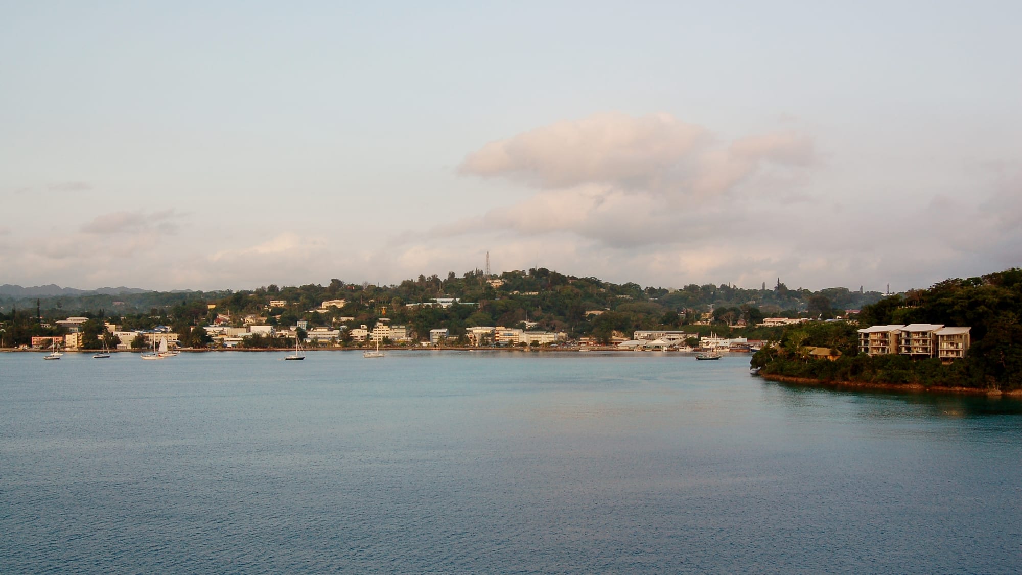
The low town of Port Vila spread along a green hillside above its calm harbour, with yachts moored offshore

Vanuatu

Port Vila

Port Vila and its harbour seen from the water, with Iririki Island at right. (Bahnfrend / Wikimedia Commons · CC BY-SA 4.0)

The capital of Vanuatu, built around a deep bay on the west coast of Efate, with the small island of Iririki in the middle of its harbour. A trading settlement that became the seat of joint British and French rule, it is now the country's port, market town and main tourist gateway, and was heavily damaged by the earthquake of December 2024.

Neighbourhoods

  • The centre and the seafront
    • First-time visitors
    • Shops and markets
    • Waterfront

    The few blocks along the waterfront road between the market and the wharf hold the banks, duty-free shops, restaurants and tour offices. It is the busiest part of the country by day, with the harbour on one side and a hillside of offices and churches on the other.

    Open in Maps
  • Iririki and the harbour
    • Resorts
    • Views
    • Quiet

    Iririki, the wooded island a few minutes by ferry from the seafront, was the British High Commissioner's residence before it became a resort. The harbour around it is used by yachts, dive boats and the cruise ships that tie up at the wharf across the water.

    Open in Maps
  • Nambatu and Nambatri
    • Best for food
    • Local life
    • Close to transport

    The districts strung along the main road south of the centre. Supermarkets, offices, nakamals, bakeries and many of the city's restaurants are here, mixed with housing and schools.

    Open in Maps
  • The inland suburbs
    • Local life
    • Quiet and residential

    Densely settled residential areas inland from the harbour, among them Elluk, built up largely by families who moved to the capital from the outer islands. Houses, small shops, churches and kava bars line the roads, and little is arranged for visitors.

    Open in Maps
  • Erakor and Pango
    • Beaches
    • Lagoons
    • Quiet

    The southern peninsulas, where the Erakor lagoon curls behind the coast and villages sit among coconut plantations. Small resorts, lagoon swimming and island restaurants reached by short ferry rides are the attraction.

    Open in Maps
  • Mele Bay
    • Beaches
    • Snorkelling
    • Day trips

    The wide bay west of the city, backed by Mele village and the hills behind it, with the best swimming and snorkelling close to the capital, a marine reserve offshore and waterfalls a short way inland.

    Open in Maps

Things to do

Landmarks and museums

  • National Museum of Vanuatumuseum

    The country's main collection, holding slit drums, canoes, Lapita pottery and ceremonial carvings, and a photographic archive of sand drawing, the continuous-line tradition recognised by UNESCO as intangible heritage.

    Open in Maps
  • Parliament of Vanuatulandmark

    The national parliament stands at Saralana Park in the middle of town, in front of the Vanuatu Cultural Centre and National Museum and close to the Malvatumauri, the national council of chiefs.

    Open in Maps
  • Independence Parkpark

    The open ground in the centre of town, faced by the Presbyterian church, used for national-day parades, sport and public gatherings.

    Open in Maps
  • The seafront promenadeviewpoint

    The walkway along Vila Bay, with shade trees, handicraft stalls, food vans and views across to Iririki.

    Open in Maps

Markets and the harbour

  • Port Vila Marketmarket

    The central market on the seafront, where women growers from villages around Efate sell root crops, greens, fruit, fish and cooked food; its market house was severely damaged in the earthquake of December 2024 and later demolished.

    Open in Maps
  • Iririki Islandattraction

    The island in the harbour, reached by a short ferry, with a shoreline walking track, swimming off the rocks and a view back over the town.

    Open in Maps

Beaches, reefs and lagoons

  • Hideaway Islandbeach

    A small island in Mele Bay, reached by a short boat ride, with a marine reserve on its seaward side and one of the world's few underwater post offices.

    Open in Maps
  • Mele Bay beachesbeach

    The long shallow bay west of the city, with sand, shade and coral close to shore, the usual swimming choice for residents of the capital.

    Open in Maps
  • Erakor Islandbeach

    A small island at the mouth of the Erakor lagoon on the outskirts of the city, minutes by ferry from the southern suburbs, with a beach and a resort.

    Open in Maps
  • Pango Pointviewpoint

    The headland about seven kilometres south of the city, with cliffs above the water and views back along the coast.

    Open in Maps

Short trips from the city

  • Mele Cascadesattraction

    A series of waterfalls and pools stepping down the hillside behind Mele village west of the city, one of the most popular recreation spots on Efate.

    Open in Maps
  • Eton Beachbeach

    A sheltered white-sand beach with a reef-protected inlet on the east coast of Efate, one of the island's best-known beaches.

    Open in Maps
  • Chief Roi Mata's Domainattraction

    A UNESCO World Heritage Site north-west of the city, taking in the residence, burial site and associated places of a paramount chief remembered in oral tradition across central Vanuatu.

    Open in Maps

Seasonal events

  • Independence Daylate July

    Vanuatu's national day on 30 July fills Independence Park and the streets with parades, string bands, sport and custom dancing from many islands.

  • Fest'Napuanannual

    The country's main music festival, set up in 1996 and held in Port Vila, with string bands, reggae and contemporary Ni-Vanuatu musicians over several days.

  • Cruise ship seasonApril to October

    Ships from Australia call at the wharf through the dry season, and market and handicraft sellers, taxis and tour operators work to their arrivals.

  • Dry-season diving and sailingMay to October

    Calmer seas and clearer water bring dive boats, yachts and fishing charters to the harbour, and the cyclone season keeps most of them away from January to March.

Eat and drink

Long-standing places and food districts in Port Vila. Hours, ratings and directions come from your maps app, always current.

Port Vila classics

  • Market food stallsmarket

    Stalls at the central market sell laplap topped with chicken, beef, octopus or fried fish alongside island cabbage, rice and taro, cooked by the women who sell the produce, and are among the cheapest meals in the city.

    Open in Maps
  • Seafront food vansrestaurant

    Vans and open-air stalls along Vila Bay sell grilled fish and chicken, chips, skewers and simboro in the evening, with tables under the trees.

    Open in Maps

Food streets and districts

  • Waterfront restaurantsneighborhood

    The waterfront road through the centre has French-influenced restaurants, cafés, bakeries and bars, a legacy of the condominium years and the reason Port Vila has a reputation for food.

    Open in Maps
  • Nambatu and Nambatri eatingneighborhood

    The districts along the main road south-east of the centre hold Vietnamese, Chinese, Japanese and island kitchens, bakeries and supermarkets used by residents rather than visitors.

    Open in Maps

Kava and bakeries

  • Nakamalsneighborhood

    Kava bars, marked by a coloured light at the gate, sell shells of freshly pounded kava from late afternoon, and the etiquette is to drink quietly.

    Open in Maps
  • French-style bakeriescafe

    Baguettes, croissants and pastries are made daily in several bakeries around the centre and the southern districts, one of the clearest traces of French rule.

    Open in Maps

Experience Port Vila

History

People have lived on Efate for around three thousand years, and Lapita pottery from the region places the island among the earliest settled in the western Pacific. The bay was part of the domain remembered in oral tradition as that of Roi Mata, a paramount chief whose residence and burial site north-west of the modern city are now a World Heritage Site. Europeans came in numbers in the 19th century after sandalwood traders and, from the 1860s, labour recruiters who took islanders to work on plantations in Queensland and Fiji.

The settlement on Vila Bay grew as British and French planters, missionaries and traders established themselves. In 1889 the town's settlers declared a self-governing commune, Franceville, an experiment that lasted only months but that extended the vote unusually widely for its day. Rivalry between the two colonial powers was settled in 1906 by the Anglo-French Condominium of the New Hebrides, a joint administration with two police forces, two legal systems, two school systems and two of almost everything else, with Port Vila as its capital. American forces used Efate as a base during the Second World War, though the larger installations were on Espiritu Santo.

The independence movement of the 1970s was led from the town, and Vanuatu became independent on 30 July 1980 under Walter Lini. Since then Port Vila has grown quickly with migration from the outer islands. Cyclone Pam caused severe damage in 2015, and the earthquake of 17 December 2024 damaged buildings and infrastructure in the centre; almost every house in the city was damaged and the market house was later demolished.

Culture & Customs

Port Vila is where the whole archipelago meets. Migrants from the country's sixty-five inhabited islands live here, each with their own language — Vanuatu has over a hundred — and Bislama serves as the common tongue, with English and French as the other official languages and a school system still divided between them. Island associations, churches and family networks organise much of social life, and people identify strongly with their home island.

Kastom, the body of customary law, knowledge and ceremony, remains authoritative alongside the state: the Malvatumauri, the national council of chiefs, meets here, and chiefs settle many local disputes. The nakamal, both a meeting place and a kava bar, is where decisions are discussed and evenings are spent, and the shell of kava is offered rather than sold in ceremonial settings. Sand drawing, made with one continuous finger line in the ground, and the slit drums and carvings in the National Museum are among the best-known art forms; string band music, reggae and gospel dominate live performance, and Fest'Napuan is the annual showcase.

Church attendance is high, mainly Presbyterian, Anglican and Catholic, and Sunday is quiet. Football is the main sport, with a league of its own in the capital, and national-day celebrations in July bring custom dance groups from across the islands into the capital. Manners are unhurried and understated; directness and impatience read as rudeness.

Daily Life

About 50,000 people live in Port Vila, roughly a sixth of Vanuatu's population, and the city has grown fast as families move in from the outer islands. Much of that growth has gone into informal settlements on the edges of the urban area, where housing, water and drainage lag behind. Custom land ownership shapes where building can happen, and leases rather than freehold underpin most development.

The economy runs on tourism, the port, government, construction and offshore financial services, with cruise passengers and Australian and New Zealand visitors the largest tourist groups. Agriculture around the city supplies the market house, and many households depend on seasonal work schemes in Australia and New Zealand, whose remittances are now a major part of national income. Two shocks fell together in 2024: the liquidation of the national airline, which cut flights, and the December earthquake, which closed offices and shops in the centre and damaged the main wharf.

Days start early, with the market and building sites busy soon after dawn and offices closing in the middle of the afternoon; the nakamals fill at dusk. Power and water are expensive, cyclone season dictates the household calendar between November and April, and the price of imported rice, tinned fish and fuel is a constant subject.

Food

Port Vila has a reputation for eating well by the standards of the Pacific, which rests on two traditions side by side. The first is Ni-Vanuatu island food, at its plainest and best at the market stalls: laplap, the national dish, is grated yam, taro, banana or breadfruit mixed with coconut cream, wrapped in banana leaves and baked in a stone oven, sometimes with chicken, beef or fish. Simboro is a steamed roll of grated banana, manioc or taro in banana leaves with coconut milk, and meals come with island cabbage, rice and fish.

The second is the French inheritance of the condominium: bakeries turning out baguettes and pastries, restaurants cooking with butter and wine, and a taste for long lunches. Vanuatu beef is a local speciality, as are reef fish, tuna, lobster and coconut crab, the last a delicacy whose capture is limited by minimum size rules.

Tanna coffee, grown in the south of the country, is served widely; local fruit juices, coconut water and Tusker, the national beer, are the standard drinks. Above all there is kava, pounded fresh from the root and drunk in nakamals at dusk, central to the city's evenings.

Planning tools

Budget

Port Vila is the most expensive place in Vanuatu, and moderately expensive for the Pacific. Almost all food and fuel is imported, and resort rooms on the water cost far more than guesthouses inland. Market meals, minibuses and the beaches keep a cheap trip possible; dive packages, hire cars and domestic flights to other islands are the items that add up.

Daily Budget Midrange
USD 150–320 (resort or hotel, restaurant meals, a dive day or island tour, some domestic travel)
Daily Budget Shoestring
USD 60–110 (guesthouse or backpackers, market and food-van meals, minibuses)

Draw vatu in the capital, since outer islands are cash-only, and book domestic flights early because capacity has been limited since Air Vanuatu was placed in liquidation in May 2024.

Best Time to Visit

May to October is the dry season: less humid, calmer seas, clearer water for diving and the lowest cyclone risk. It is also the busiest stretch, with cruise calls and school holidays from Australia and New Zealand. November to April is hot, wet and quieter, and cyclones are most likely between January and March.

Suggested Number of Days

Two or three days cover the city, the market and the nearby bays. Five to seven allow a circuit of Efate and a trip to another island, which needs slack for weather and domestic flights. Divers and sailors stay longer.

First Visit
2–3 days
With Surroundings
5–7 days

Transportation

Minibuses are the main way to move around the capital: they have no fixed routes, are flagged down, and drop passengers in turn for a flat fare within the urban area. Taxis are metered or negotiated. Hire cars and scooters suit the road around Efate.

Agree a taxi fare before setting off, and say the destination to a minibus driver before boarding, as he may be heading the other way.

Airport & Station Connections

Bauerfield International Airport lies just north of the centre, a short drive from town, with flights from Australia, New Zealand, Fiji and New Caledonia and domestic services to the other islands. Cruise ships berth at the wharf across the harbour from the town, and yachts clear customs in Vila Bay.

Walkability

The centre is walkable: the market, the seafront, the museum and the shops lie within about two kilometres along the waterfront. Beyond that the city climbs steep hills, footpaths are patchy or absent, and the heat and traffic make walking unpleasant, so residents use minibuses for even short journeys.

Safety

Vanuatu is generally safe, and violent crime against visitors is uncommon, but petty theft, bag-snatching and break-ins occur in the capital, and walking alone at night away from the seafront is not advised. Natural hazards are the greater concern: a magnitude 7.3 earthquake struck offshore on 17 December 2024, killing at least 14 people and damaging buildings in the town centre, and cyclones affect Efate in the wet season. Medical facilities are limited.

Keep valuables out of sight and use a taxi after dark, take advice on malaria and dengue precautions before travelling, follow cyclone and tsunami warnings, and carry insurance covering medical evacuation. Check current official travel advice before travelling.

Climate

Tropical, hot and humid, cooled by south-east trade winds. The wet season from November to April brings heavy rain, high humidity and the cyclone risk; May to October is drier and more comfortable. Rain often comes in short heavy bursts rather than all day.

Summer
hot and humid — summer runs December to February in the southern hemisphere, with days around 29 to 31°C and the heaviest rain
Winter
warm and drier — June to August days are typically around 25 to 27°C, with nights near 19 to 20°C and steady trade winds

Local Customs

Bislama, the English-based creole, is the shared language, and a greeting before business is expected. Dress is modest in town and in villages, with swimwear kept to beaches and resorts. Land and reefs are mostly held under custom ownership, so access to a beach, waterfall or garden is often arranged with the local community, sometimes for a small fee. Kava, drunk in nakamals from late afternoon, is the social institution.

Ask before photographing people, villages or ceremonies, ask permission before crossing custom land, keep voices low in a nakamal, and note that tipping and bargaining are not customary.

Common Payment Methods

The currency is the vatu (VUV). Banks, ATMs and card payment are available in Port Vila, and hotels, restaurants and larger shops take cards, although surcharges are common. Markets, minibuses, taxis, nakamals and everything on the outer islands need cash, so vatu should be drawn before leaving the capital.