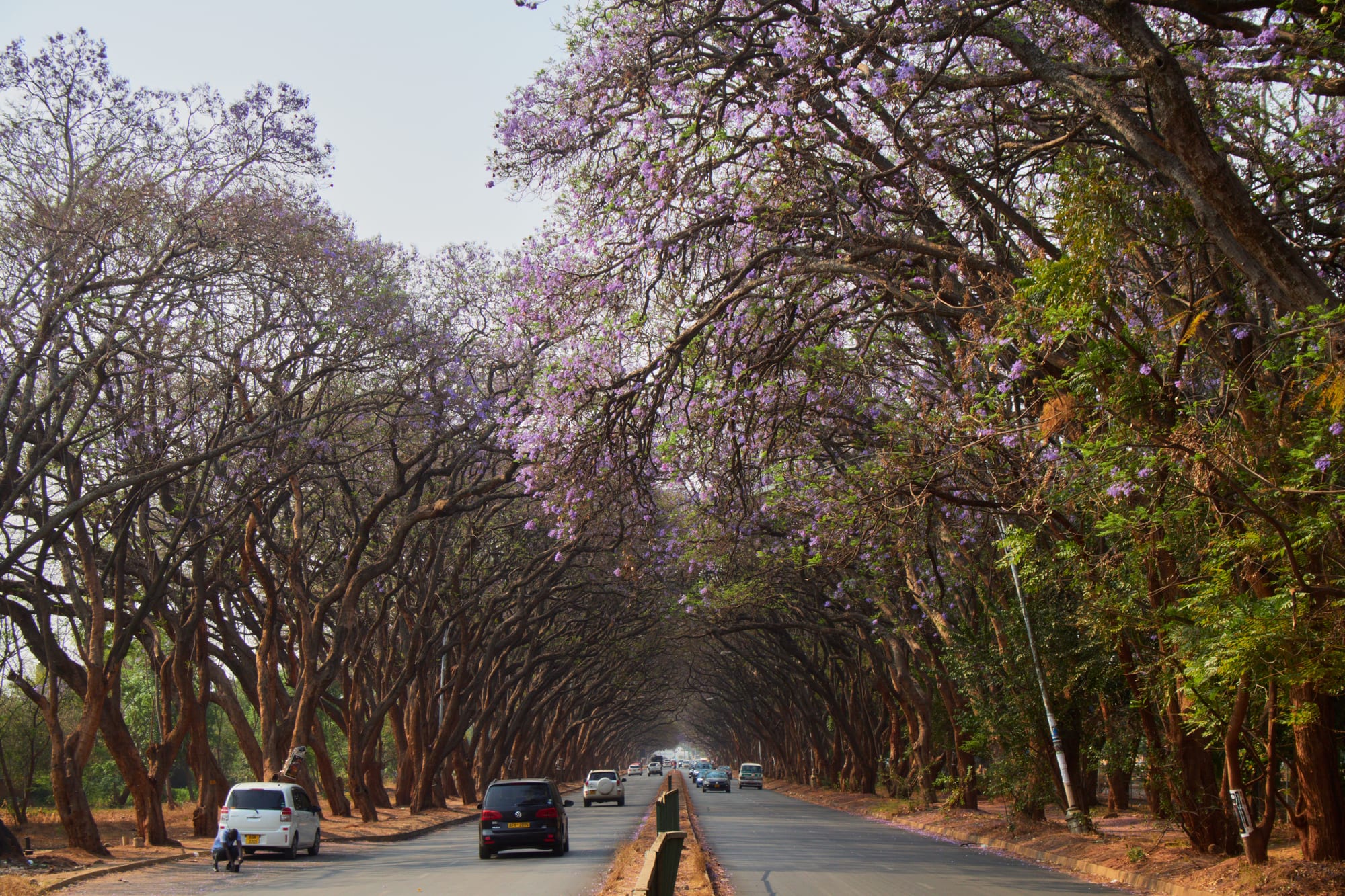
Jacaranda trees in purple flower arching over both sides of a divided road, with cars driving between them

Harare & Mashonaland, Zimbabwe

Harare

Jacarandas in flower over a divided avenue in Harare. (lumoplank / Wikimedia Commons · CC0)

Zimbabwe's capital and largest city, founded in 1890 as Fort Salisbury on the high plateau and renamed Harare in 1982. It is the seat of government and the centre of the country's business, universities and media, a low-rise, tree-shaded city of wide avenues and garden suburbs whose galleries, sculpture gardens and produce markets sit alongside a large informal economy.

Neighbourhoods

  • The city centre
    • First-time visitors
    • Museums and galleries
    • Close to public transport

    The grid of streets laid out below the Kopje, holding the government offices, banks, the National Gallery and Harare Gardens. It is busy and crowded by day with vendors, commuters and kombis, and empties in the evening, when most visitors move out to the suburbs.

    Open in Maps
  • Avondale
    • Best for food
    • Shops
    • Close to the centre

    A leafy suburb a short drive north of the centre, built around a shopping centre with cafés, restaurants, bookshops and a weekend flea market. Its streets of older houses and flats sit close to the University of Zimbabwe, and it is one of the easiest areas to walk in.

    Open in Maps
  • Borrowdale
    • Quiet and residential
    • Shops
    • Families

    A wealthy suburb in the far north of the city, with large gardens, shopping complexes, a racecourse and many of the embassies and guesthouses. It is spread out and needs a car, but it is the calmest part of Harare.

    Open in Maps
  • Mbare
    • Markets
    • Local life
    • Music

    The oldest township, laid out south of the centre in the early colonial city and still the busiest part of Harare. Mbare Musika, the national produce market, and the long-distance bus terminus are here, along with a craft market and a long tradition of musicians.

    Open in Maps
  • Highfield
    • History
    • Local life

    A south-western township closely tied to the nationalist movement, where much of the political organising of the 1950s and 1960s took place. It is residential and busy, with markets, churches and football grounds, and little aimed at visitors.

    Open in Maps
  • Mount Pleasant
    • Quiet and residential
    • Students

    A northern suburb around the University of Zimbabwe campus, with tree-lined streets, student housing and a small shopping centre. It is a practical, unshowy base between the centre and the far northern suburbs.

    Open in Maps

Things to do

Museums and galleries

  • National Gallery of Zimbabwemuseum

    The country's main art museum, opened in 1957, whose workshop school helped launch the Shona stone sculpture movement; it shows work by Zimbabwean artists in stone, metal and wood alongside painting, drawing and installation.

    Open in Maps
  • Museum of Human Sciencesmuseum

    Formerly the Queen Victoria Museum and opened in 1903, with collections on Zimbabwean archaeology, ethnography and prehistory, including a model Shona village and the Ngoma Lungundu, the oldest wooden object found in sub-Saharan Africa.

    Open in Maps
  • Chapungu Sculpture Parkattraction

    An open-air park of Zimbabwean stone sculpture on the eastern edge of the city, long associated with the artists of the Shona sculpture movement.

    Open in Maps

Landmarks and viewpoints

  • The Kopjeviewpoint

    The granite hill above the south-west corner of the centre, at 1,540 metres the highest point in Harare, where the first town grew up and from which the views take in the whole city.

    Open in Maps
  • Africa Unity Squarelandmark

    A large public square near the Civic Centre on the southern edge of the city centre, one of the open spaces of the Causeway district.

    Open in Maps
  • University of Zimbabwelandmark

    The country's oldest university, opened in 1952 in the northern suburb of Mount Pleasant, with a wooded campus that is central to the city's intellectual life.

    Open in Maps
  • Sacred Heart Cathedrallandmark

    The Roman Catholic cathedral in the city centre, on Fourth Street, and the seat of the Metropolitan Archdiocese of Harare.

    Open in Maps
  • Eastgate Centrelandmark

    A shopping and office complex of the 1990s known internationally for a passive cooling system modelled on the ventilation of termite mounds.

    Open in Maps
  • National Heroes' Acrelandmark

    A national monument and burial ground on a hillside west of the centre, built with North Korean assistance and dedicated to figures of the liberation war.

    Open in Maps
  • Rufaro Stadiumattraction

    The football ground in Mbare, home to Dynamos, where Bob Marley played at the celebrations of independence in 1980.

    Open in Maps
  • National Sports Stadiumattraction

    The country's largest stadium, west of the centre beside the National Heroes' Acre, used for international football and rugby and for national ceremonies.

    Open in Maps

Parks and gardens

  • Harare Gardenspark

    The spacious park in the city centre, between the business district and the Avenues, with a swimming pool and an open-air theatre.

    Open in Maps
  • Harare Sports Clubattraction

    The city's main cricket ground, beside the gardens in the centre, which has hosted Test and one-day internationals since the 1990s.

    Open in Maps
  • National Botanic Gardenspark

    Gardens north of the centre laid out to show the trees and plants of Zimbabwe's different regions, from miombo woodland to lowveld species.

    Open in Maps
  • Mukuvisi Woodlandspark

    A wildlife reserve of indigenous woodland inside the city, founded in 1980, with trails, viewing platforms and game including zebra, giraffe, eland and impala.

    Open in Maps

Markets

  • Mbare Musikamarket

    Zimbabwe's largest produce market, where lorries from the farming districts unload maize, tomatoes, greens and fruit, beside a craft market and the main long-distance bus terminus.

    Open in Maps

Short trips from the city

  • Domboshavaviewpoint

    A granite whaleback about 27 km north, a national monument, with rock paintings in a cave below the summit and a short climb to views across the plateau.

    Open in Maps
  • Lake Chivero Recreational Parkpark

    The reservoir on the Manyame River that supplies Harare's water, about 30 km south-west, protected with its hinterland as Lake Chivero Recreational Park and listed as a Ramsar wetland, with game in the park and boating and fishing on the lake.

    Open in Maps
  • Ewanrigg Botanical Gardenspark

    Botanical gardens in the farmland beyond the city, run by the national parks authority and reached by a short turn-off from the Shamva road.

    Open in Maps

Seasonal events

  • Independence Day celebrationsApril

    The anniversary of independence on 18 April, marked with an official ceremony at a main stadium and with music and family gatherings across the city.

  • Harare International Festival of the Artslate April or early May

    A multi-day festival of music, theatre and dance founded in 1999, held around the Harare Gardens area.

  • Heroes' DayAugust

    A public holiday on the second Monday of August commemorating the liberation war, with ceremonies at the National Heroes' Acre.

  • Jacaranda seasonSeptember and October

    The city's jacaranda-lined avenues flower purple in the weeks before the rains, followed by the red of the flamboyant trees.

Eat and drink

Long-standing places and food districts in Harare. Hours, ratings and directions come from your maps app, always current.

Harare classics

  • Sadza and relish at a city-centre canteenrestaurant

    Plain lunch canteens around the centre serve sadza with muriwo, beans, beef or chicken stew, eaten by hand — the everyday meal of the city.

    Open in Maps
  • Braai stands and beer gardensrestaurant

    Grilled beef and goat, often with sadza and a relish, cooked over coals at stands and beer gardens, busiest on weekend afternoons.

    Open in Maps

Markets and food districts

  • Mbare Musikamarket

    The city's produce market, where most of Harare's fruit, vegetables, grain and dried fish arrive, with cooked-food stalls around the edges.

    Open in Maps
  • Avondale shopping centreneighborhood

    Cafés, bakeries and restaurants around a suburban shopping centre north of the centre, with a weekend market in the car park.

    Open in Maps
  • Borrowdale restaurantsneighborhood

    The northern suburbs hold most of Harare's sit-down restaurants, coffee shops and bars, spread between shopping complexes.

    Open in Maps

Experience Harare

History

Harare began on 12 September 1890, when Cecil Rhodes's Pioneer Column halted on the open plateau below a granite hill and raised the British flag at what they named Fort Salisbury, after the British prime minister. The rocky kopje gave the settlement its first shelter and its name for the surrounding district; the town grew on the flat ground to the north-east, laid out in a grid of wide streets designed, like Bulawayo's, for wagon teams. It became a municipality in 1897 and the capital of the self-governing colony of Southern Rhodesia in 1923.

Rail links to Beira and to the south turned Salisbury into a commercial and administrative centre for a farming economy built on tobacco and maize, and the town filled with offices, banks and the head branches of companies. African residents were confined to townships laid out at a distance from the white suburbs — Mbare, then Highfield — and these became the seedbed of nationalist politics in the 1950s and 1960s, when meetings in Highfield's halls shaped the movements that grew into ZANU and ZAPU. The city was the capital of the Federation of Rhodesia and Nyasaland from 1953 to 1963 and of Ian Smith's unrecognised state after 1965, and during the liberation war it was ringed by security measures while fighting continued in the countryside.

Independence was celebrated at Rufaro Stadium in April 1980, and Salisbury was renamed Harare in 1982, after the Shona chief Neharawa. The city expanded quickly as movement controls ended. The economic crises that followed hit it hard: hyperinflation that peaked in 2008, the demolitions of Operation Murambatsvina in 2005, and the succession of currencies since. In November 2017 soldiers and crowds in the streets of Harare brought Robert Mugabe's 37 years in power to an end.

Culture & Customs

Harare is the country's cultural clearing house. Stone sculpture is the art form most associated with it: a workshop attached to the National Gallery in the late 1950s and 1960s encouraged a generation of Shona carvers working in serpentine and springstone, and their successors still carve in yards and roadside studios around the city, with pieces held in collections abroad.

Music runs through the city's life. The mbira, a thumb piano of metal keys played at ceremonies for the ancestors, underlies the chimurenga music that Thomas Mapfumo built in the townships in the 1970s; sungura, gospel and, since the 2010s, Zimdancehall from Mbare's home studios come out of the kombis and bars. Mbare and Highfield have produced musicians, footballers and politicians in roughly equal measure, and their reputation in the city rests on all three.

Everyday manners follow Shona practice: greetings before any transaction, deference to elders, and a soft clap of the hands in thanks. Church life is strong and highly visible, from Catholic and Methodist congregations to the white-robed apostolic groups who meet in the open on Sunday mornings on patches of ground around the suburbs. English, Shona and a good deal of Ndebele mix on the streets, and Harare's humour about its own difficulties is a recognised local trait. Football is followed closely, with the city's clubs playing at Rufaro and the National Sports Stadium, and cricket has a long base in the northern suburbs.

Daily Life

About 1.8 million people lived in the city at the 2022 census, and about 2.5 million in the surrounding Harare Metropolitan Province, which takes in the satellite town of Chitungwiza to the south — the largest urban concentration in the country. Harare holds the ministries, the parliament, the University of Zimbabwe, the main hospitals, the banks and the newspapers, and much of the formal economy that remains.

That formal economy is small relative to the population, and the informal one is what most households live on: vendors on the pavements, cross-border traders, minibus crews, tuckshops, backyard workshops and money-changers. Salaries are often paid partly in US dollars and partly in ZiG, and prices are quoted in both. Power cuts are a normal part of the week, and generators, solar panels and batteries are widespread in businesses that can afford them; water supply in parts of the city is intermittent, and boreholes are common.

The daily rhythm starts early, with kombis filling from the townships before dawn and the centre busy by seven. The north of the city — Avondale, Mount Pleasant, Borrowdale — has gardens, shopping complexes and private schools; the south and west — Mbare, Highfield, Glen View, Budiriro — are denser and poorer, and the distance between the two is the most obvious fact about Harare. Many families depend on money sent by relatives in South Africa or Britain, and rural homes in the Mashonaland districts remain the place people return to for funerals, holidays and retirement.

Food

Sadza is the centre of almost every meal: stiff white maize-meal porridge, cooked thick, eaten by hand and rolled into a ball to scoop up the relish beside it. Muriwo, greens such as covo or pumpkin leaves cooked with tomato and onion and often peanut butter, is the usual accompaniment, along with beans, matemba or kapenta (small dried fish from Lake Kariba), or a stew of beef, goat or chicken. Free-range village chicken, called road runner, is valued above the commercial kind, and a slower-cooked bird is a mark of a proper meal.

Meat grilled over coals — nyama, usually beef or goat — is the food of weekends and gatherings, sold at braai stands and beer gardens and often bought raw at a butchery counter and cooked on the spot, a way of eating that suits the city's sociability. Mopane worms, dried and fried with onion and tomato, appear in markets in season. Breakfast is bota, a thinner maize porridge with peanut butter or sugar; maputi, puffed maize, and roasted maize cobs are sold at roadsides; freezits, frozen flavoured ice in plastic sleeves, are the children's street snack.

Mbare Musika supplies most of the city's fruit, vegetables and grain, and its surrounding stalls sell cooked food to traders and travellers all day. Drinks run from Chibuku, the opaque sorghum-and-maize beer sold in cartons and known as Shake Shake, to maheu, a non-alcoholic fermented maize drink, bottled lagers brewed in the city's industrial south, and Mazoe orange cordial, named after the citrus valley north of Harare and drunk in almost every household.

Planning tools

Budget

Harare has the country's widest range of places to stay, from backpacker lodges and guesthouses in the northern suburbs to business hotels in and around the centre. Local food, markets and kombis are inexpensive; hotel rooms, restaurant meals in the northern suburbs and car hire are priced in US dollars and cost much the same as in neighbouring capitals.

Daily Budget Midrange
USD 120–300 (city hotel, restaurant meals, car hire or hired driver, day trips out of town)
Daily Budget Shoestring
USD 40–70 (guesthouse or lodge bed, sadza and market food, kombis, entry to a museum)

Carry small, clean US dollar notes; cards work in larger hotels, supermarkets and northern-suburb restaurants but rarely elsewhere.

Best Time to Visit

The dry months from May to October are the most settled, with sunny days, cold nights in June and July and warm, dusty heat by October. September and October bring the jacaranda and flamboyant flowering. The rains from November to March are green and mild, with heavy afternoon storms that can make driving slow.

Suggested Number of Days

Two days cover the city's galleries, parks and markets at an easy pace. Three or four allow for the granite country and lakes within an hour or two of the city. Traffic and the distance between suburbs stretch any plan, so allow more time without a car.

First Visit
2 days
With Surroundings
3–4 days

Transportation

Harare spreads over a wide area and most residents travel by kombi — shared minibuses that run fixed routes from ranks around the centre, cheap, crowded and without printed timetables. Metered taxis and ride-hailing apps operate in the city and are the usual choice for visitors, along with hire cars and hired drivers. There are no scheduled passenger trains.

Agree a taxi fare before setting off if the meter is not used, and keep small notes for kombi and taxi journeys.

Airport & Station Connections

Robert Gabriel Mugabe International Airport lies south-east of the centre, roughly half an hour by road, and is the country's main gateway, with regional flights to Johannesburg, Nairobi and Addis Ababa and domestic flights to Victoria Falls and Bulawayo. Intercity coaches and minibuses connect Harare with the main towns and with South Africa and Zambia, arriving at terminals near Mbare and the centre.

Walkability

The city centre is a flat grid and easy to cross on foot in daylight, with the gallery, the gardens and the main streets close together. Beyond it the suburbs are spread out, with long blocks, few pavements in places and distances of several kilometres between shopping centres, so walking between districts is impractical and walking after dark is not advised.

Safety

Harare has the country's highest levels of street crime, with pickpocketing, bag-snatching and car break-ins in the city centre, and political protests can turn violent. Police roadblocks are frequent on the roads out of the city. Power cuts are common, leaving streets and stairwells dark, and pavements and roads are often in poor repair.

Take malaria precautions in the low-lying areas, avoid political gatherings, don't drive at night, keep documents and small change ready for roadblocks, and don't swim in still fresh water outside managed sites. Central Harare is best avoided on foot after dark, and taxis are the usual way to move between suburbs at night. Check current official travel advice before travelling.

Climate

Harare stands at about 1,500 metres, which keeps it mild for the tropics. The year divides into a warm wet season from November to March, a cool dry season from May to August and a hot dry spell in September and October before the rains. Summer here falls in December to February.

Summer
warm and wet, with days around 25–28°C and heavy afternoon storms
Winter
dry and sunny, with days around 20–23°C and nights that can approach freezing in June and July

Local Customs

Greetings come before business: a handshake and an exchange about health and family are expected, and elders are greeted first. Shona speakers often clap softly in thanks or greeting. Dress is generally neat and modest in town and in churches. Tipping is not obligatory but around ten per cent is appreciated in restaurants, and small notes are given to car guards.

Ask before photographing people, and do not photograph soldiers, police, roadblocks, the State House or other government buildings; discussion of politics with strangers is best left alone.

Common Payment Methods

The official currency is the ZiG, the gold-backed unit introduced in 2024, but the US dollar is used for the large majority of transactions, and tourism, fuel and larger dealings are generally priced in dollars. Clean, recent US dollar notes in small denominations are the most useful thing to carry, as change is a constant difficulty. Cards are accepted in larger hotels, supermarkets and northern-suburb restaurants; mobile money is widely used by residents, and ATMs are unreliable.