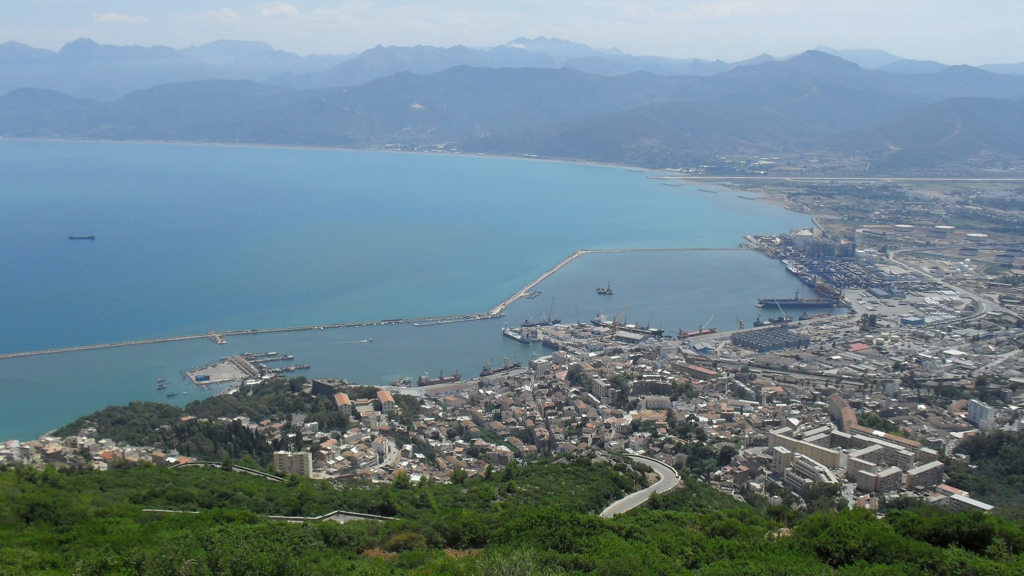
The bay of Béjaïa seen from a green hillside, with the port breakwater, the old town on a headland and hazy mountains beyond

Algiers & Kabylie, Algeria

Béjaïa

Béjaïa, its port and bay seen from the slopes of Mount Gouraya. (Khebweb / Wikimedia Commons · CC BY-SA 4.0)

A Mediterranean port in Kabylie, set on a wide bay beneath the limestone bulk of Mount Gouraya. Capital of the Hammadid dynasty in the 11th century and a major medieval trading city, it is now an industrial and university town with a Kabyle old quarter, cliffs and coves on the headland of Cap Carbon, and beaches along the corniche east of the centre.

Neighbourhoods

  • The old town and the Casbah quarter
    • Historic district
    • First-time visitors

    The oldest part of Béjaïa, climbing from the harbour in narrow streets and stairways towards the remains of its Hammadid and Ottoman walls and gates. Small shops, mosques and the fort of Bordj Moussa are within a short walk of each other.

    Open in Maps
  • The town centre
    • First-time visitors
    • Best for food
    • Close to public transport

    The French-era grid around the main square and the Boulevard de la Liberté, where the banks, hotels, cafés and the market are concentrated. Most buses and shared taxis start from here, and the seafront is a few minutes away.

    Open in Maps
  • Brise de Mer and the port side
    • Walks by the sea
    • Best for food

    The stretch of shore between the town and the harbour, with a promenade, fish restaurants and views of the cranes and ferries. It is where people walk in the evening.

    Open in Maps
  • Sidi Ahmed and the upper slopes
    • Quiet and residential
    • Views

    Residential districts climbing the hillside towards the Gouraya park gate, mostly apartment blocks and small houses, with long views down over the bay and the road up to the cliffs.

    Open in Maps
  • The corniche towards Tichy
    • Beaches
    • Families

    The coast road east of the city passes coves, hotels and sandy beaches that fill with Algerian holidaymakers in July and August, continuing towards the resort towns of Tichy and Aokas.

    Open in Maps

Things to do

The coast and the mountain

  • Gouraya National Parkpark

    The protected massif above the town, with limestone cliffs, Aleppo pine and oak woods, walking paths and a population of Barbary macaques.

    Open in Maps
  • Cap Carbonviewpoint

    A high rocky headland beyond the Gouraya massif, reached by a corniche road and a footpath, with a lighthouse built in 1906 on the cliff above the sea, the highest in the world by its altitude.

    Open in Maps
  • Yemma Gourayaviewpoint

    The 660-metre summit above the bay, crowned by an old fort and held by tradition to be the resting place of the saint who gives the mountain its name, a steep walk up from the town for the widest view of the coast.

    Open in Maps
  • Les Aiguadesbeach

    A small pebble cove on the road out to Cap Carbon, backed by cliffs and pine woods, popular for swimming in summer.

    Open in Maps

The old town

  • Bordj Moussalandmark

    A fort above the old town, one of the city's listed national monuments, inside the perimeter the Spanish held after 1510 and later used by the Ottomans and the French.

    Open in Maps
  • Port of Béjaïatransit hub

    One of Algeria's main commercial ports, handling oil, containers and ferries to Marseille, and the reason the city grew where it did.

    Open in Maps

Short trips along the coast

  • Tichyattraction

    A seaside town about 12 km east with the busiest beaches on this coast, hotels and summer crowds.

    Open in Maps
  • Aokasattraction

    A small coastal town under cliffs east of Béjaïa, known for its beach and for the caves in the rock above it.

    Open in Maps
  • Kherrataattraction

    An inland town about 35 km away at the mouth of the Kherrata gorges, where the road is cut into the cliff face above the river.

    Open in Maps
  • Ouzellaguenlandmark

    The commune in the Soummam valley where, at Ifri, the Congress of Soummam met in August 1956 and set out the organisation of the independence movement.

    Open in Maps
  • Toudjaattraction

    A village in the hills west of the city with springs and the remains of the Roman aqueduct that once supplied Saldae, the ancient Béjaïa.

    Open in Maps

Mountains inland

  • Djurdjura National Parkpark

    The limestone range at the heart of Kabylie, with cedar forest, caves and the Lalla Khedidja summit, reached by mountain roads west of the Soummam valley.

    Open in Maps

Seasonal events

  • YennayerJanuary

    The Amazigh new year, marked across Kabylie with family meals, music and village celebrations, and a public holiday.

  • The olive harvestlate autumn and winter

    Families return to the hill villages to pick olives, and the small mills around the Soummam valley press the year's oil.

  • Summer beach seasonJuly and August

    The corniche east of the city fills with Algerian holidaymakers and the emigrant families who come back from France for the summer.

Eat and drink

Long-standing places and food districts in Béjaïa. Hours, ratings and directions come from your maps app, always current.

Markets and food streets

  • Béjaïa central marketmarket

    Fruit, vegetables, olives, dried figs and fish from the bay, with bread and pastry shops on the surrounding streets.

    Open in Maps
  • Fish restaurants by the harbourneighborhood

    Grilled sardines, sea bream and prawns served simply near the port and along the seafront promenade.

    Open in Maps
  • Town centre caféscafe

    Coffee, mint tea and pastries on the main boulevard, where much of the city's social life takes place.

    Open in Maps

Experience Béjaïa

History

The bay was settled in antiquity as Saldae, a Carthaginian and then Roman port, supplied with water by an aqueduct from the springs at Toudja. Its great period began in 1067, when the Hammadid ruler an-Nasir moved his capital here from the Qal'a in the mountains and built a walled city of palaces and mosques along the shore. For two centuries Béjaïa was one of the busiest ports of the western Mediterranean, trading wax, olive oil, leather and grain with Pisa, Genoa and Marseille, and a centre of learning where scholars from across the Maghreb taught. The young Leonardo Fibonacci learned Hindu–Arabic numerals in the city while his father worked there as a merchant, and the wax trade gave French its word for a candle, bougie, from the city's French name.

Spain took the town in 1510 and held it until the Ottomans drove them out in 1555, after which it became a provincial port of the Regency of Algiers rather than a capital. French forces captured it in 1833, and colonial Béjaïa grew modestly around the harbour while the Kabyle hills behind it resisted until 1857 and rose again in 1871.

In 1956 the Congress of Soummam met at Ifri, in the valley inland, and set out the political organisation of the independence movement. Saharan oil made the port a pipeline terminal, and after independence the city expanded with refineries, food industries and a university. It has also been a centre of the Berber cultural movement, from the protests of 1980 to those of 2001.

Culture & Customs

Béjaïa is one of the two main cities of Kabylie, and Kabyle culture shapes daily life. The Kabyle language is heard everywhere, Tifinagh letters and the Amazigh flag appear on walls and shopfronts, and Yennayer, the Amazigh new year in January, is a family occasion as much as a public holiday. Village life in the hills behind the city still keeps collective institutions, including the assembly known as the tajmaât and shared work at harvest.

Music is central. The Kabyle song tradition of Idir, Lounis Aït Menguellet, Matoub Lounès and the many groups that followed them mixes poetry, the mandole and the bendir, and it carries a long-running argument about language, memory and identity. Concerts, poetry evenings and theatre in Kabyle draw large audiences, and the university gives the city a young and politically engaged population.

Crafts survive in the surrounding villages: hand-formed pottery painted with geometric patterns, silver and enamel jewellery from the Ath Yenni area, and woven blankets. Religion is mostly Sunni Islam, observed in a comparatively relaxed public style, and small Christian congregations exist in the region. Hospitality is emphatic — refusing a second helping takes persistence — and family occasions, above all weddings, bring emigrant relatives home from France each summer.

Daily Life

The city counted about 178,000 people at the 2008 census, with many more in the towns and villages along the bay and up the Soummam valley. The port, an oil terminal, food and plastics industries, and the University of Béjaïa are the main employers, alongside the summer tourist trade on the corniche. Several well-known Algerian food companies are based in the area, which has given the city a reputation for private enterprise.

People live mostly in apartment blocks spreading up the slopes and along the valley, with the older quarters near the harbour more crowded and harder to maintain. Many households depend partly on money sent from relatives in France, where the Kabyle diaspora is large, and on olives and figs from family land in the hills. Young people leave for Algiers or abroad, and the villages refill in summer and at Yennayer.

The rhythm is provincial: early mornings, a long afternoon, and a slow evening walk along the seafront when the heat eases. Water shortages in dry summers, traffic on the single coastal road, housing and unemployment are the everyday complaints, and the state of the road and rail links to Algiers is a standing local grievance.

Food

Béjaïa eats Kabyle mountain food with a coastal edge. Olive oil is the base of almost everything, pressed in village mills after the winter harvest and poured over bread, salads and vegetables. Aghrum, a flat wheat or semolina bread baked on a clay griddle, accompanies stews; berkoukes, a large hand-rolled pasta grain, is simmered in a broth of vegetables and meat; and couscous appears in many forms, including a plain version with buttermilk.

From the sea come sardines, anchovies and bream, grilled over charcoal or fried whole, and stalls near the harbour sell them with bread and harissa. The market is full of the products of the hills: dried figs, carob, honey, wild herbs, peppers and the year's olives in barrels of brine. Seksu s bzar, couscous with pulses and seasonal vegetables, is the ordinary family meal rather than a feast dish.

Sweets lean on semolina, dates and honey: makroud, griwech and the syrup-soaked cakes made for Ramadan. Coffee is drunk short and strong, mint tea is offered to guests, and the region bottles mineral water from mountain springs. Figs and fresh oranges from the Soummam valley are sold from the back of vans at the roadside in season.

Planning tools

Budget

Béjaïa is cheaper than Algiers, though hotel prices on the corniche rise sharply in July and August when Algerian families take their holidays. Café meals, shared taxis and buses cost little, and the beaches and the walks in the Gouraya park are free. Everything is paid for in dinar cash.

Daily Budget Midrange
USD 110–220 (mid-range hotel in town or on the coast, restaurant meals, taxis or a hired driver)
Daily Budget Shoestring
USD 30–55 (simple hotel, café and street food, buses and shared taxis)

Book ahead for the summer weeks, when the coast east of the city is full, and bring euros to change, as foreign cards are rarely accepted.

Best Time to Visit

May, June, September and early October combine warm sea temperatures with space on the beaches and comfortable walking weather on Mount Gouraya. July and August are hot, humid and crowded. Spring is green and wet, Kabylie being one of the rainier parts of Algeria, and winter is mild on the coast but stormy.

Suggested Number of Days

Two days are enough for the town, the headland and a beach. Four allow the corniche east of the city, the Soummam valley and a day in the mountains of Kabylie, where the roads are slow and winding.

First Visit
2 days
With Surroundings
4 days

Transportation

The city is served by buses and shared taxis, which also run along the corniche and up the Soummam valley, and a railway line links it with Algiers. Roads out of town climb steeply and the coastal corniche is narrow, so journeys take longer than the distances suggest. Many visitors hire a car or a driver for the mountain villages.

Traffic into the city backs up badly in summer and at rush hour; travelling early in the day makes a noticeable difference.

Airport & Station Connections

Soummam – Abane Ramdane Airport lies about 5 km south of the centre and has domestic flights and flights to France. Béjaïa is roughly 220 km east of Algiers, about four hours by road along the coast or through the Soummam valley, with trains, coaches and shared taxis on the same routes. Ferries connect the port with Marseille.

Walkability

The centre and the old town are compact and best seen on foot, though the streets between the harbour and the upper quarters are steep and heavy on the legs. The seafront promenade is an easy walk. Reaching the park gate, Cap Carbon or the corniche beaches means a long uphill walk or a taxi.

Safety

Béjaïa is a calm provincial city with the ordinary risks of petty theft in crowds and on busy beaches. The main hazards are traffic on narrow coastal roads, strong currents off some beaches where there are no lifeguards, and unmarked paths on the cliffs above the sea. Police checkpoints are common on roads inland.

Walking the higher Gouraya paths is best done in daylight and, on unfamiliar routes, with local company. Most governments advise against all travel to the border regions with Mali, Niger, Libya, and Mauritania, and to parts of the Saharan interior, citing terrorism and kidnapping risk. Check current official travel advice before travelling.

Climate

Mediterranean and noticeably wet by Algerian standards, as the mountains behind the bay catch rain from the sea. Summers are hot and humid with almost no rain; autumn and winter bring long spells of rain and storms, and snow falls on the mountains inland rather than on the coast.

Summer
hot and humid, generally around 29°C by day, with warm sea and little rain
Winter
mild and wet, generally 8–17°C, with heavy rain and cloud over the mountains

Local Customs

This is a Kabyle city: Kabyle (Taqbaylit) is spoken at home and in the villages, alongside Algerian Arabic and French, and Amazigh identity is displayed openly in flags, music and shop signs. Public life is somewhat more relaxed than in much of Algeria, but modest dress is still expected away from the beaches. Hospitality is taken seriously, and an invitation to eat is not a formality.

A greeting in Kabyle — azul — is appreciated; ask before photographing people, and avoid photographing the port, military sites and police.

Common Payment Methods

The currency is the Algerian dinar and cash is used for nearly everything. Foreign cards are accepted in very few places and cash machines that take them are scarce, so visitors bring euros or US dollars to change. The official bank rate is much weaker than the widely used parallel rate, and changing money outside the banking system is technically illegal.