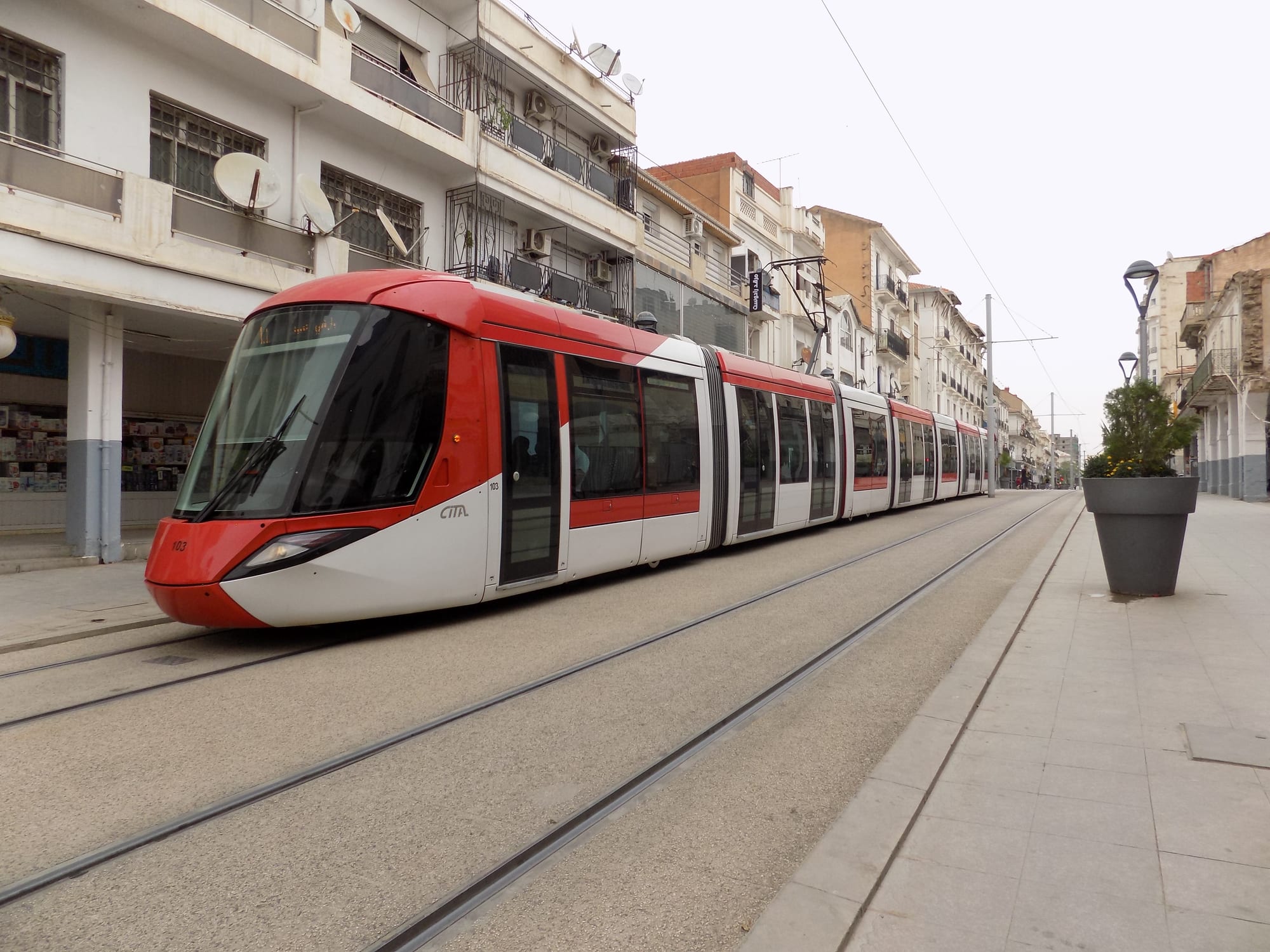
A red and white tram running down a paved pedestrian street lined with balconied apartment blocks and shops

Constantine & the East, Algeria

Sétif

A tram on the pedestrianised main street in the centre of Sétif. (Zach1055 / Wikimedia Commons · CC BY-SA 4.0)

A city of the eastern high plateaus, standing above 1,000 metres in wheat and sheep country between Algiers and Constantine. Roman Sitifis and later a Byzantine fortress, it is now a commercial and university city known for its fountain, its mosaic museum, its football club and its position an hour from the Roman ruins of Djémila.

Neighbourhoods

  • The city centre
    • First-time visitors
    • Cafés
    • Close to public transport

    The colonial grid around the fountain and the pedestrianised main avenue, with the market streets, the theatre, banks, patisseries and most of the hotels. The tramway runs through it and everything central is within a short walk.

    Open in Maps
  • The park quarter
    • Families
    • Parks

    The green district around the city's leisure park, with gardens, fairground rides and a small zoo that draw families at weekends, surrounded by apartment blocks and cafés.

    Open in Maps
  • Bel Air and the northern districts
    • Quiet and residential
    • Local life

    Residential neighbourhoods climbing gently north of the centre, a mixture of older villas and newer apartment estates, with local markets and schools rather than sights.

    Open in Maps
  • El Hidhab
    • Students
    • Modern city

    The university and stadium district on the southern edge of the city, planned around Ferhat Abbas University and the large football stadium, with student housing, wide roads and newer housing estates.

    Open in Maps
  • Ain Trik and the eastern edge
    • Quiet and residential

    Newer suburbs spreading towards the Constantine road, largely apartment blocks built to house the city's fast growth, with shops and small markets serving them.

    Open in Maps

Things to do

Landmarks in the city

  • Ain El Fouara fountainlandmark

    The city's emblem, a fountain of 1898 with a marble statue at its centre, standing where the main avenues meet and fed by water from the hills.

    Open in Maps
  • The Byzantine citadellandmark

    The walls and towers of the fortress built in the 6th century under Byzantine rule on the site of the Roman town, on open ground at the edge of the centre.

    Open in Maps
  • Avenue 1er Novembreattraction

    The pedestrianised spine of the city centre, lined with shops, cafés and patisseries and crossed by the tramway, busiest in the early evening.

    Open in Maps

Museums and ancient sites

  • National Public Museum of Sétifmuseum

    The city's national museum, built east of the old citadel and best known for the Roman mosaics lifted from Sitifis and the surrounding countryside, alongside prehistoric, Numidian and Islamic collections.

    Open in Maps
  • The Roman remains of Sitifislandmark

    Fragments of the Roman colony founded for army veterans at the end of the 1st century, including a bath building with mosaics and the site of two late-4th-century Christian basilicas.

    Open in Maps

Parks and walks

  • Parc d'Attractionspark

    A leisure park in the heart of the city with gardens, walking paths, fairground rides and a small zoo, the main open space for families.

    Open in Maps
  • The market streetsmarket

    The lanes east of the main avenue, packed with clothing, spice, vegetable and household stalls, where Sétif's reputation as a trading city is most obvious.

    Open in Maps

Short trips from the city

  • Djémilalandmark

    Roman Cuicul, a UNESCO World Heritage Site since 1982 and under an hour's drive north-east, with forums, temples, a theatre, a triumphal arch and a museum of mosaics on a mountain ridge.

    Open in Maps
  • Kherrata and its gorgeviewpoint

    A town north of Sétif beside a narrow limestone canyon cut by the Agrioun river, followed by a road of tunnels and ledges carved into the cliffs.

    Open in Maps
  • El Eulmaattraction

    The second-largest town in Sétif Province, about 25 kilometres east of the city, and a trading centre whose markets draw buyers from well beyond the plateau.

    Open in Maps
  • Béjaïaattraction

    A Mediterranean port city north of the plateau, backed by the cliffs and coves of the Gouraya headland, a long but feasible day out by road.

    Open in Maps

Seasonal events

  • Football seasonautumn to spring

    Matches of the city's long-established club fill the stadium on the southern edge of town and are followed closely across the province.

  • Ramadan eveningsvaries with the lunar calendar

    The centre empties by day and fills after sunset, with patisseries, cafés and the market streets busy until late.

  • The 8 May commemorationsMay

    The events of 1945 are marked each year with ceremonies at the city's memorials and in the towns of the surrounding province.

  • Summer cultural weeksJuly and August

    Concerts, theatre and craft fairs are staged in the parks and halls during the school holidays, when many families return from abroad.

Eat and drink

Long-standing places and food districts in Sétif. Hours, ratings and directions come from your maps app, always current.

Plateau classics

  • Chakhchoukha and couscousrestaurant

    The staples of the high plains — torn flatbread in a spiced lamb and chickpea sauce, and couscous with mutton and seasonal vegetables — served in plain restaurants around the centre.

    Open in Maps
  • Grilled meats and merguezrestaurant

    Sheep country food, with skewers, chops and spiced merguez sausages grilled over charcoal and eaten with bread and salad.

    Open in Maps

Markets and sweet shops

  • The central marketmarket

    Cereals, pulses, dried fruit, olives, cheese and vegetables from the plateau farms, alongside butchers and bakeries, in the streets east of the main avenue.

    Open in Maps
  • Patisseries of the centrecafe

    Trays of baklawa, makroud filled with dates, griwech and almond sweets, made in quantity before Eid and for weddings, sold along the pedestrian avenue.

    Open in Maps

Experience Sétif

History

The plateau around Sétif has been farmed since prehistory, and the Numidians held it before Rome. The Roman colony of Sitifis was founded for army veterans around the end of the 1st century AD and grew into the capital of the province of Mauretania Sitifensis, a town of baths, basilicas and estates in the middle of a grain country whose surplus was shipped from the coast. Christianity took root early, and two large Christian basilicas were built at the edge of the town at the end of the 4th century.

After the Vandal period the Byzantines fortified the site in the 6th century, building the citadel whose walls still stand. Under Arab and Berber rule the town shrank to a village on the caravan routes between the coast and the interior, and by the early 19th century little of the Roman city remained visible. French forces occupied the site in 1838 and laid out a new garrison town on a grid inside the old Byzantine walls, which became a centre of colonial cereal farming.

On 8 May 1945, as crowds across Algeria celebrated the end of the war in Europe, police fired on a nationalist demonstration in Sétif; the riots that followed killed about a hundred European settlers, and the repression across Sétif, Guelma and Kherrata that followed killed thousands of Algerians, with the toll still disputed. Those events are widely seen as a turning point on the road to the war of independence that began in 1954. Since 1962 Sétif has grown rapidly into one of Algeria's largest inland cities, with a university, a tramway and a reputation for commerce.

Culture & Customs

Sétif has a reputation in Algeria for trade and hard work. The city and the towns around it, El Eulma above all, are known for merchants who import and distribute goods across the country, and that commercial character shapes the way people speak about their own city. It is conservative in manner, with an important religious and reformist tradition inherited from the ulama movement of the 1930s.

Football is the city's great passion. Its club, founded in the 1950s and one of the most successful in Algerian and North African competition, gives Sétif a national profile, and match days fill the roads towards the stadium on the southern edge of town. The 1945 events are the other pillar of local identity, commemorated in monuments, street names and the annual ceremonies in May.

Culturally the plateau belongs to the eastern Algerian world of malouf and of bedoui sung poetry, and Chaoui and Kabyle influences meet here, since Sétif sits between the Aurès and Kabylie and has drawn families from both. Weddings run for days, with henna nights, long meals and music; trays of sweets are exchanged between households at Eid; and the Ain El Fouara fountain in the centre serves as the place everyone meets, photographs and argues about.

Daily Life

About 288,000 people lived in the city at the 2008 census, and well over a million in the province, which is one of the most populous in Algeria. The city has grown quickly, spreading south towards the university and east along the Constantine road in estates of apartment blocks, while the colonial grid at the centre remains the commercial heart.

The economy rests on agriculture and trade. The surrounding high plains produce wheat, barley, pulses and sheep, and Sétif's food processing, dairies and light industry work with that produce; wholesale trade, construction and the university employ much of the rest. The province is also one of the main sources of Algerian emigration to France, and money and visitors flow back each summer.

Life is ordered by the plateau climate: early starts, markets busy in the morning, a pause in the heat of summer afternoons, and cafés full in the evening. Winter is a real constraint, with frost, wind and snow that can cut roads to the mountain villages for days. Housing shortages, traffic in the centre and youth unemployment are the usual complaints, and the tramway, opened in 2018, has changed how people cross the city.

Food

Sétif eats the food of the high plains, built on wheat, lamb and pulses. Chakhchoukha — thin flatbread torn into pieces and soaked in a sauce of lamb, chickpeas, tomato and spices — is the dish of celebration, and couscous, steamed semolina under a stew of mutton and seasonal vegetables, is the Friday meal in most homes. Trida, small squares of hand-cut pasta in a chicken and chickpea sauce, is the festive alternative.

Soups and breads carry the cold months. Chorba frik, the tomato and green-wheat soup, breaks the fast throughout Ramadan; hearty lentil and chickpea dishes are everyday food; and kesra and matlou, flat semolina breads baked on a griddle, are made at home and sold from small bakeries. Sheep from the plateau give grilled chops, skewers and merguez sausages, and dried and preserved meat still appears in winter cooking in the villages.

The city is proud of its sweets, which draw on the eastern Algerian repertoire: baklawa layered with almonds, makroud stuffed with dates and fried, griwech twisted and dipped in honey, and rfiss, crumbled semolina bread worked with butter and honey. They are made in quantity for weddings and for Eid and sold from the patisseries along the main avenue. Strong black coffee and mint tea are drunk at all hours, and the water of the Ain El Fouara fountain is still carried home by some families.

Planning tools

Budget

Sétif is a business and trading city rather than a tourist one, which keeps hotel prices moderate and the choice reasonable. Most visitors spend more on transport than on rooms, since seeing Djémila usually means hiring a car with a driver for the day. Cash is used almost everywhere.

Daily Budget Midrange
USD 90–190 (mid-range hotel, restaurant meals, a driver for Djémila or the Kherrata road)
Daily Budget Shoestring
USD 35–60 (simple hotel, café meals, the tram and shared taxis)

Bring euros or US dollars to change; foreign cards are rarely accepted and ATMs taking them are scarce.

Best Time to Visit

April to June and September to October are the best months, when the plateau is green or golden and the days are warm without the summer glare. Summer is hot and very dry. Winter is genuinely cold at this altitude, with frost, strong winds and snow that can close mountain roads.

Suggested Number of Days

The city itself is a comfortable day. Two or three days allow for the Roman sites and the mountain roads north, each of which takes the best part of a day once travel is counted. Winter weather can slow any trip out of the city.

First Visit
1 day
With Surroundings
2–3 days

Transportation

A tramway links the university and stadium district with the centre and the eastern neighbourhoods, and buses and shared taxis cover the rest and the nearby towns. Coaches leave frequently for Algiers, Constantine, Béjaïa and Batna, the railway serves the main northern line, and the East–West Highway passes just outside the city.

Shared taxis are the usual way to reach Djémila and El Eulma; they leave when full rather than to a timetable.

Airport & Station Connections

Sétif's airport lies west of the city at Ain Arnat, handling domestic and some international flights. Trains and coaches connect the city with Algiers in around four to five hours and with Constantine in about two, and the East–West Highway makes road travel across the north straightforward. Many visitors arrive by road from Constantine or Béjaïa.

Walkability

The centre is flat, laid out on a grid and easy to walk, with a long pedestrianised avenue at its heart and the fountain, market streets, museum and citadel all within a few minutes of one another. Outside this core the city spreads into wide avenues and housing estates that are better covered by tram or taxi. Winter cold and wind make walking less pleasant.

Safety

Sétif is a calm provincial city, with the ordinary petty crime of crowded markets and bus stations. The main practical hazards are traffic, winter ice and snow on the plateau roads, and mountain routes north of the city that are narrow and exposed in bad weather. Police checkpoints on the highways are routine.

Identification should be carried for checkpoints, police and military sites should not be photographed, and mountain roads are best driven in daylight and good weather. Keep to main roads in the border provinces, cooperate with checkpoints and escorts, and avoid lonely mountain walks without a local guide. Check current official travel advice before travelling.

Climate

A semi-arid highland climate at about 1,100 metres, with a wide gap between day and night temperatures all year. Rain falls mainly between autumn and spring, summers are hot and dry, and winters are among the coldest of any large Algerian city.

Summer
hot and dry, often 30–35°C by day, with cool nights
Winter
cold, with days around 10°C, nights near freezing, and frequent frost, wind and snow

Local Customs

The plateau is socially conservative and family-centred. Modest dress is expected, greetings are unhurried and formal, and hospitality — coffee or tea, and an insistence on feeding a guest — is taken seriously. Mosques are generally not open to non-Muslim visitors, and Friday morning is quiet across the city.

Ask before photographing people or market stalls, dress with shoulders and knees covered, expect a changed rhythm during Ramadan, and note that alcohol is not sold openly and public drinking is unacceptable.

Common Payment Methods

The currency is the Algerian dinar. Cash is used for nearly everything, from hotels to taxis and the market; foreign cards work only in a few larger establishments and ATMs that accept them are hard to find. Euros and US dollars are the currencies travellers bring to change.