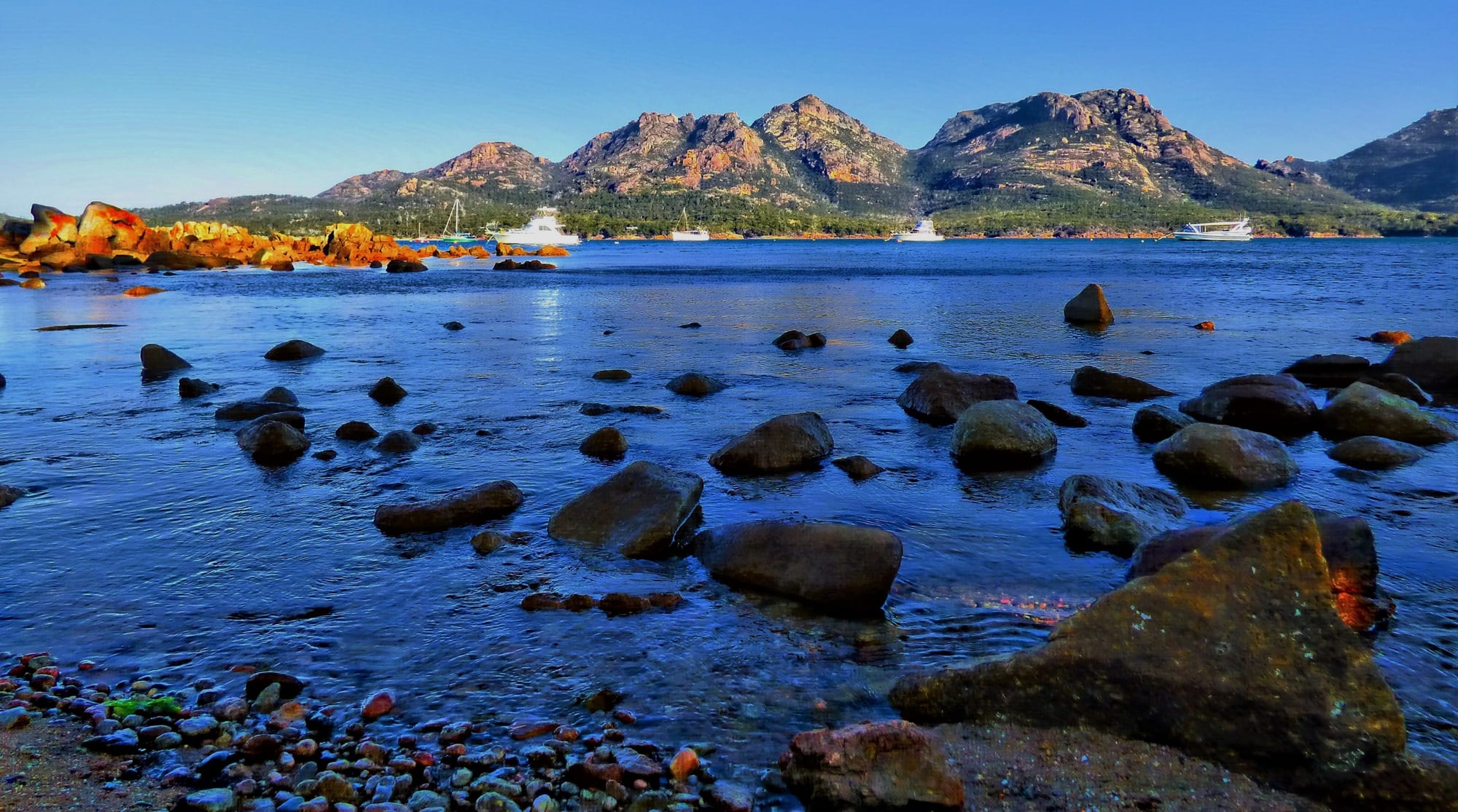
Boulders in shallow clear water on a sheltered bay, with bare granite peaks rising behind

Tasmania, Australia

Coles Bay

The shore at Coles Bay, on the Freycinet Peninsula on the east coast of Tasmania. (Queentulip / Wikimedia Commons · CC BY-SA 4.0)

A small village on the east coast of Tasmania, set on the sheltered water of Great Oyster Bay beneath the pink granite peaks known as the Hazards. It grew from whaling, mining and fishing into the gateway settlement for Freycinet National Park, and now lives almost entirely on visitors walking to Wineglass Bay, boating on the bay and eating the shellfish farmed nearby.

Neighbourhoods

  • The Esplanade and the township
    • First-time visitors
    • Close to the water
    • Shops and food

    The centre of the village, a short grid of streets behind a beach and a jetty on Great Oyster Bay. The general store, bakery, tavern and boat operators are here, along with holiday houses and cabins, and the Hazards fill the view across the water.

    Open in Maps
  • Freycinet Drive and the park entrance
    • Walkers
    • Camping
    • Quiet and residential

    The road south of the village that runs into Freycinet National Park past Richardsons Beach, Honeymoon Bay and the park's campgrounds before reaching the Wineglass Bay car park. Accommodation here is a mix of campsites, cabins and lodges among the coastal scrub.

    Open in Maps
  • Swanwick
    • Quiet and residential
    • Views of the Hazards

    A scattered residential locality a few kilometres north of the village on the road in, with houses on the hillside and a boat ramp. It is quieter than the township and has the widest views back to the peninsula.

    Open in Maps
  • Friendly Beaches
    • Beaches
    • Surf
    • Remote camping

    A long white surf beach reached by an unsealed side road north of the town, inside the national park. There is basic camping, no services and often nobody else in sight; swimming is exposed and the water is cold.

    Open in Maps

Things to do

Walks and viewpoints

  • Wineglass Bay Lookoutviewpoint

    A steep track up to the saddle between two of the Hazards, from which the curve of Wineglass Bay appears below; the path continues down to the beach itself.

    Open in Maps
  • Mount Amostrail

    A short but demanding scramble over bare granite slabs to the 454-metre summit of Mount Amos, one of the five Hazards, with the peninsula and Great Oyster Bay spread out below.

    Open in Maps
  • Hazards Beach circuittrail

    A day-long loop from the Wineglass Bay car park over the saddle and back along the western side of the peninsula, passing Aboriginal shell middens above the sand.

    Open in Maps
  • Cape Tourvilleviewpoint

    A short boardwalk around a headland with a small lighthouse, looking down sea cliffs and along the outer coast towards Wineglass Bay.

    Open in Maps
  • Sleepy Bayviewpoint

    A rocky cove of orange-lichened granite a few minutes' walk from the road, popular for rock pools and dawn light.

    Open in Maps

Beaches and the water

  • Honeymoon Baybeach

    A tiny sheltered inlet framed by granite boulders just inside the national park, one of the easiest places to swim and a favourite spot at sunset.

    Open in Maps
  • Richardsons Beachbeach

    A calm curve of sand beside the park campground, with the Hazards behind and shallow water suitable for children and kayaks.

    Open in Maps
  • Great Oyster Bayattraction

    The wide, sheltered bay between the peninsula and the Tasmanian mainland, used for sailing, sea kayaking, fishing and boat cruises along the coast.

    Open in Maps
  • Moulting Lagoonpark

    A shallow coastal lagoon at the head of the bay, a wetland of international importance for black swans and other waterbirds.

    Open in Maps

Short trips from the town

  • Bichenoattraction

    A fishing town north along the coast, with a granite blowhole, a rocky foreshore walk and a little penguin colony on Diamond Island alongside it.

    Open in Maps
  • Swanseaattraction

    An older town on the far shore of Great Oyster Bay, with colonial buildings, a bark mill museum and the vineyards of the east coast wine area nearby.

    Open in Maps
  • Maria Islandpark

    A car-free national park island reached by ferry from Triabunna to the south, with convict ruins at Darlington, painted sandstone cliffs and abundant wildlife.

    Open in Maps

Seasonal events

  • Summer holiday seasonDecember to January

    The village fills with Tasmanian and mainland families, campgrounds are fully booked and the boat operators run at capacity; it is the liveliest and most crowded time of year.

  • Freycinet ChallengeOctober

    A multi-sport event held on the peninsula each year, combining ocean kayaking, road cycling and running between the beaches and tracks around the town.

  • Australian Three Peaks RaceEaster

    A continuous sailing and running race from Beauty Point to Hobart that stops here, its crews running from the town to climb Mount Freycinet.

Eat and drink

Long-standing places and food districts in Coles Bay. Hours, ratings and directions come from your maps app, always current.

Coles Bay classics

  • Oyster and mussel farm gaterestaurant

    Shellfish grown in Great Oyster Bay is sold on the road into town to eat on the spot at outdoor tables, along with rock lobster and other local seafood in season.

    Open in Maps
  • The Esplanade shopsneighborhood

    The village centre holds a general store, a bakery, a tavern and a handful of cafés and restaurants — the whole of the town's eating out, and most of it closes early out of season.

    Open in Maps

Markets and produce

  • Coles Bay general storemarket

    The small supermarket and bottle shop that supplies self-caterers and campers; the choice is limited and prices are higher than in the larger towns.

    Open in Maps
  • East coast wine cellar doorsneighborhood

    Cool-climate vineyards along the Tasman Highway north and south of the Coles Bay turn-off pour pinot noir, chardonnay, riesling and sparkling wine, several with views over Great Oyster Bay.

    Open in Maps

Experience Coles Bay

History

Bands of the Oyster Bay people gathered along this coast for thousands of years, harvesting shellfish and marine plants between the bay and the peninsula and leaving large shell middens that are still visible above the sand at Hazards Beach and elsewhere in what is now the national park. Disease and the violence of the colonial frontier in the early 19th century destroyed that way of life across eastern Tasmania, and Aboriginal Tasmanian communities today trace descent largely through the Bass Strait islands.

Europeans came for what could be taken from the bay. George Meredith set up a shore-based whaling station in 1824, which worked only through the winter months and had been abandoned by the 1850s; the Hazards are said to be named after a whaling captain, Richard Hazard. Tin and coal miners and pastoralists followed, leaving mine shafts and abandoned huts that walkers still pass, and fishing for crayfish and scallops supported a handful of families. The peninsula and its islands carry the name of Louis de Freycinet, a member of the French scientific expedition that charted parts of the Tasmanian coast in the early 1800s.

Protection changed the village's fortunes. Freycinet was declared a national park in 1916, Tasmania's first along with Mount Field, and after the Second World War a sealed road, electricity and holiday shacks turned Coles Bay into a summer settlement for Tasmanian families. Photographs of Wineglass Bay from the saddle above it became one of the state's defining images in recent decades, and the village rebuilt itself around walkers and cruise boats rather than whaling and fish.

Culture & Customs

Coles Bay's culture is the culture of the Tasmanian shack: a low-key holiday settlement where families have returned to the same cabins for generations, where boats sit on trailers in front gardens, and where the summer day is measured by the tide and the wind rather than by opening hours. In January the population multiplies and the beach at Richardsons and the jetty fill with children, fishing lines and kayaks; by May the streets are almost empty again.

Outdoor life is the shared language. Almost every conversation in the village touches on the walks — who made it up Mount Amos, whether the saddle track was crowded, how the weather looks for the circuit — and on fishing and diving for crayfish and abalone, a serious pastime on this coast with strict seasons and limits. Local businesses are small, family-run and often seasonal, and staff in summer include many young travellers on working holidays.

Conservation is part of local identity, and also a source of argument. Residents live inside or beside a national park that draws large numbers of visitors, and debates run over walking-track upgrades, private developments on the peninsula, parking at the Wineglass Bay car park and how many people the place can take. The Aboriginal history of the peninsula is increasingly acknowledged in park interpretation, including the shell middens above the beaches. The village banned plastic shopping bags in 2003, one of the first places in the world to do so.

Daily Life

About 500 people live in Coles Bay and the surrounding area all year, yet Freycinet National Park draws visitors in numbers that dominate the economy of this part of the east coast. The difference shapes everything: a village of holiday houses that stand dark for much of the year, a primary-aged population small enough that older children travel to school at Bicheno or Swansea, and a workforce that swells and shrinks with the seasons.

Tourism provides nearly all the work — cabins, lodges, cafés, boat cruises, kayak and walking guides, park management — alongside marine farming of oysters and mussels in the bay, commercial fishing and building trades serving holiday-house owners. Shopping, banking and medical appointments generally mean a drive to Swansea, Bicheno or further to Launceston or Hobart.

The day runs early: boats out at first light, walkers on the tracks before the heat, and quiet streets after dark. Housing is the main local issue, as holiday letting has absorbed much of the modest housing stock and seasonal staff struggle to find anywhere to live. Water supply in dry summers, bushfire preparedness and the pressure of visitor numbers on a single access road are the other recurring concerns.

Food

Seafood from the water in front of the village defines eating here. Pacific oysters, native oysters and mussels are grown in the bay and sold beside the road into town, usually eaten shucked and raw or grilled with little more than lemon; southern rock lobster, known throughout Tasmania as crayfish, is the local luxury, and scallops, flathead and squid come off the boats. The scallop pie — scallops in a mild curried sauce inside shortcrust pastry — is a Tasmanian bakery speciality found in the village as it is across the state.

Beyond seafood, the food is straightforward holiday cooking: bakery pies and sausage rolls, fish and chips eaten on the jetty, barbecues at the campgrounds, and a few small restaurants working with Tasmanian produce — beef and lamb, berries, cheeses and leatherwood honey from the western rainforests. Self-catering is the norm, and many visitors arrive with a boot full of food bought in Hobart or Launceston.

The surrounding east coast is one of Tasmania's wine districts, its cool nights and long ripening season suited to pinot noir, chardonnay, riesling and sparkling wine; cellar doors line the Tasman Highway within a short drive of the Coles Bay turn-off. Tasmanian single malt whisky, craft beer and cider round out the local drinks list, and cold-climate fruit — cherries, raspberries and blackcurrants — appears in the farm stalls and bakeries in summer.

Planning tools

Budget

Coles Bay is a holiday village with few beds and a short season, so accommodation is the dominant cost and rises sharply from December to February and over Easter. A hire car is effectively essential, national park entry is charged per vehicle or per person, and boat cruises and guided kayak trips are the other large items. Self-catering and walking keep a visit cheap, as the park's best-known walks cost nothing beyond the pass.

Daily Budget Midrange
USD 190–330 (cabin, cottage or lodge room, restaurant and seafood meals, a hire car, park pass and a boat trip)
Daily Budget Shoestring
USD 90–140 (campsite or hostel bed, self-catering from the store, a shared hire car and a park pass)

Book beds and campsites months ahead for the summer school holidays, and buy a holiday parks pass if visiting more than one Tasmanian national park.

Best Time to Visit

December to March has the warmest, driest weather and the longest days for walking and swimming, but also the crowds and the highest prices. Late spring and early autumn are the best compromise, with mild days, clear light and quiet tracks. Winter is cold and windy, some businesses reduce their opening, and the peninsula is at its emptiest.

Suggested Number of Days

Two days suit most visits, enough for the main walks and time on the water. Three or four allow the longer circuits on the peninsula and the towns and vineyards along the east coast. Weather is the main variable, since a wet, windy spell closes off the high granite walks.

First Visit
2 days
With Surroundings
3–4 days

Transportation

Almost everyone arrives and moves around by car; the village, the park entrance and the walk car parks are spread over several kilometres of one road. A limited coach service connects the east coast towns, and some accommodation and tour operators run transfers, but there is no local public transport. Bicycles, kayaks and boat trips are all available in the village, and parking at the Wineglass Bay car park fills up in the middle of the day in summer.

Drive slowly at dusk and after dark, when wallabies, possums and wombats come onto the roads around the town.

Airport & Station Connections

The town is reached only by road, on Coles Bay Road, which leaves the Tasman Highway between Swansea and Bicheno. Hobart is roughly 190 kilometres away, about two and a half to three hours by car, and Launceston is a similar drive; both have airports, and most visitors pick up a hire car there or bring one on the Devonport ferry. Fuel and shopping are easier in Swansea or Bicheno than in the village itself.

Walkability

The township is small enough to cross on foot in fifteen minutes, and the beach, jetty, store and tavern are all close together. Everything else — the park entrance, Honeymoon Bay, the Wineglass Bay car park, Cape Tourville — lies several kilometres down Freycinet Drive, on a road without footpaths, so walking between them is not practical. The park's own tracks are the real walking, and they range from flat boardwalks to steep granite scrambles.

Safety

Crime is very rare in the village. The risks are outdoor ones: exposed granite slopes that become slippery when wet, sudden changes of weather, cold water and strong currents on the ocean beaches, sunburn under Tasmania's high ultraviolet levels, and bushfire in hot, dry summers. Mobile coverage is patchy on the peninsula's tracks, and snakes are present in the scrub.

Carry water, warm layers and waterproofs on every walk, tell someone the intended route, swim only at the sheltered beaches unless confident in surf, and check fire danger ratings in summer. Check current official travel advice before travelling.

Climate

Cool temperate and maritime, and one of the drier, sunnier corners of Tasmania because the peninsula sits in the lee of the island's mountains. Seasons are reversed from the northern hemisphere: summer runs from December to February and winter from June to August. Sea breezes and strong westerlies are common all year, and the water stays cold.

Summer
mild to warm, generally about 12–23°C, with occasional hot northerly days above 30°C and cool, breezy evenings
Winter
cool and often windy, roughly 5–14°C by day, with frosts, rain and snow on the Tasmanian mountains inland

Local Customs

Manners are informal and small-town: people say hello on the tracks, and shorts and walking clothes are normal everywhere in the village. Tipping is not expected in Australia, though rounding up or leaving a little for good service is welcome. Shops and kitchens keep short hours out of season, and the town effectively closes early in the evening. Shell middens along the shore are Aboriginal heritage and are protected, so nothing should be moved or collected.

Take all rubbish out of the park, keep to marked tracks on the granite and off private driveways, do not feed wallabies or possums, and remember that alcohol is sold only to over-18s and drink-driving limits are strictly enforced.

Common Payment Methods

The currency is the Australian dollar. Cards and contactless payment are accepted by the store, tavern and tour operators, and many businesses prefer them. Banking services in the village are minimal, so it is worth drawing cash in Hobart, Launceston, Swansea or Bicheno before arriving, particularly for campground fees and small purchases.