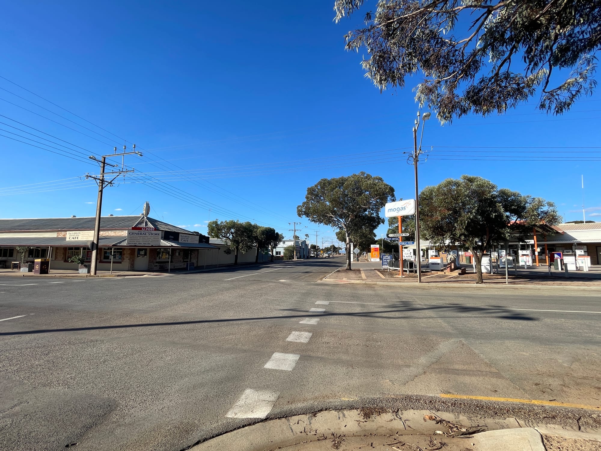
An empty crossroads in a small outback town, with a stone general store, a cafe and a fuel station under a deep blue sky

South Australia, Australia

Hawker

The crossroads of Flinders Ranges Way and Cradock Road in the centre of Hawker. (Pru.mitchell / Wikimedia Commons · CC BY-SA 4.0)

Hawker is a small town on the western edge of the Flinders Ranges in South Australia, about 365 kilometres north of Adelaide and the closest settlement to Wilpena Pound. Laid out in 1880 as a railway and wheat town on land too dry to farm, it now lives on fuel, supplies and beds for travellers heading into Ikara-Flinders Ranges National Park.

Neighbourhoods

  • Hawker township
    • First-time visitors
    • Fuel and supplies
    • Cheapest beds

    Four streets around a crossroads where the road north to Wilpena Pound meets the road south-east to Cradock. The hotel, the general store, the fuel station, a caravan park, the visitor information counter and the school stand within a couple of hundred metres of each other.

    Open in Maps
  • Wilpena Pound
    • Closest to the walks
    • Camping

    The natural amphitheatre in the heart of the national park, about 55 kilometres north of the town. A resort, a campground and the walking tracks are inside the Pound, which puts visitors at the trailheads but far from shops, fuel and mobile coverage.

    Open in Maps
  • Rawnsley Park and the southern Pound
    • Station stays
    • Quiet and residential

    Sheep-station country under the southern rim of the Pound, roughly halfway between the town and the park entrance. Working stations here let cabins, cottages and campsites, with the red wall of Rawnsley Bluff above and dirt tracks running out into the scrub.

    Open in Maps
  • Cradock and the eastern plains
    • Quiet and residential
    • Ruins and back roads

    Flat saltbush and grain country south-east of Hawker, scattered with the stone ruins of farms abandoned in the droughts. Cradock, a tiny settlement with an old pub, sits about 20 kilometres out on the road towards Orroroo.

    Open in Maps

Things to do

Short trips into the ranges

  • Ikara-Flinders Ranges National Parkpark

    The park north of the town, built around Wilpena Pound and the folded quartzite ridges either side of it, with walks, gorges, rock art and campgrounds.

    Open in Maps
  • St Mary Peakviewpoint

    At 1,189 metres the highest point on the rim of Wilpena Pound and in the Flinders Ranges; Adnyamathanha people regard the peak as a sacred place and ask that it not be climbed.

    Open in Maps
  • Brachina Gorgetrail

    A gorge crossed by a dirt road that cuts down through the folded rock layers of the ranges, with yellow-footed rock-wallabies on the scree.

    Open in Maps

Short trips north and south

  • Blinmanattraction

    A former copper-mining village in the hills north of the park and the highest surveyed town in South Australia, where the old mine is open to visitors.

    Open in Maps
  • Parachilnaattraction

    A handful of buildings on the plain north-west of the park, at the western end of the road through Parachilna Gorge, known for its hotel.

    Open in Maps
  • Kanyakaattraction

    The ruins of a pastoral station south of Hawker, started in 1852 and long abandoned, with roofless stone buildings, a woolshed and a cemetery, and a waterhole nearby.

    Open in Maps
  • Nilpena Ediacara National Parkpark

    A former cattle station west of the ranges whose rock beds hold fossils of some of the earliest complex animals, seen on guided fossil tours in the cooler months.

    Open in Maps
  • Quornattraction

    A railway town south of Hawker at the northern end of Pichi Richi Pass, surveyed in 1878 for the line north and still lined with stone hotels and shopfronts from the days when trains to the interior ran through it.

    Open in Maps
  • Pichi Richi Railwayattraction

    A preserved narrow-gauge railway that runs steam and heritage trains through the Pichi Richi Pass between Quorn and Port Augusta, on part of the old line north.

    Open in Maps

Seasonal events

  • Wildflowers after the winter rainAugust to October

    When winter rain has fallen, the plains and gorges flower, with Sturt's desert pea, everlastings and wattle, and the ranges turn briefly green.

  • Hawker Cup race meetingLate May

    The Hawker Racing Club's annual thoroughbred meeting, which draws people in from stations and towns across the district.

  • Easter and the winter school holidaysMarch or April, and July

    The busiest weeks of the year, when campgrounds inside the park and the few rooms in the town fill with families and four-wheel-drive travellers.

  • Shearing and musteringspring and autumn

    Not a public event, but the seasons that bring station workers, shearers and stock trucks into the town and fill the pub.

Eat and drink

Long-standing places and food districts in Hawker. Hours, ratings and directions come from your maps app, always current.

Hawker's own

  • Hawker Hotelrestaurant

    The stone pub with verandahs at the crossroads, and the social centre of the district — counter meals, cold beer and the local noticeboard.

    Open in Maps
  • The general store and roadhousemarket

    Groceries, pies, coffee, fuel and gas bottles; the last full supply point for anyone heading into the park or north up the Flinders Ranges Way.

    Open in Maps

Eating in the ranges

  • Prairie Hotel, Parachilnarestaurant

    An outback hotel north-west of the park with a reputation well beyond the region for native and 'feral' meats, including camel, kangaroo, emu and goat.

    Open in Maps
  • Camp kitchens and station tablesneighborhood

    Beyond the two pubs the choice narrows to the resort's dining room at Wilpena, a few station kitchens and cooking over a fire, so most travellers carry food in.

    Open in Maps

Experience Hawker

History

The Flinders Ranges are Adnyamathanha country. In Adnyamathanha tradition the walls of Wilpena Pound are the bodies of two akurra, giant serpents, which came to rest around a gathering place; Ikara, now part of the national park's name, means meeting place. People have lived and travelled through these gorges for tens of thousands of years, and painted and engraved sites survive across the district.

European pastoralists took up runs from the 1850s. Kanyaka, south of the present town, was started as a cattle station in 1852 and later ran sheep before it was abandoned. In 1865 the colony's Surveyor-General, George Goyder, drew a line across the map marking the limit of rainfall reliable enough for cropping. A run of unusually wet years tempted wheat farmers north of it anyway, and in 1880 the government surveyed a town on the plain and named it after George Hawker, a pastoralist and member of the colonial parliament. It stood on the railway then being pushed north from Port Augusta towards Marree, the route later travelled by the old Ghan.

For a few seasons the wheat grew. Then the rain failed, the droughts of the 1880s proved Goyder right, and the farms were walked off, leaving the stone shells that still stand in the paddocks. Hawker held on as a railway town and a service centre for sheep stations. When the main line was moved west in 1956, the town turned to the traffic going north instead, and the national park became its living.

Culture & Customs

This is station country, and the culture is that of a small, scattered community that depends on distance being managed rather than removed. The hotel is the meeting place, the noticeboard and the mail conversation; station families drive in for supplies and stay to talk. Football and netball clubs draw players from properties across the district, and the Royal Flying Doctor Service and distance education for station children are ordinary parts of life rather than curiosities.

Adnyamathanha culture is present and increasingly visible: guides, rangers and tour operators explain Yura Muda, the creation stories tied to particular hills, waterholes and gorges, and the national park is managed with Adnyamathanha involvement. Requests about how sites are treated are taken seriously here, and visitors are expected to follow them.

The ranges also have a place in Australian art. Hans Heysen painted them repeatedly, fixing the image of white-trunked gums against red rock in the national imagination, and the long-distance Heysen Trail is named after him. Photographers and painters still come for the light in the hour after dawn. Road manners matter more than social ones: a raised finger off the wheel to oncoming vehicles, a slow pass on gravel, and gates left exactly as they were found.

Daily Life

A few hundred people live in Hawker, which makes it a small town even by outback standards, though it serves a district of stations and travellers many times that number. The town has a hotel, a general store and fuel, a caravan park, an area school, a health service, a police station and a volunteer fire brigade, and that list is close to complete.

The economy rests on three things: sheep and cattle stations, the tourist traffic heading into the ranges, and the trucking and contracting that keep both supplied. Trade is strongly seasonal, heavy from Easter through to October and thin in the summer heat. Anything not sold in town comes from Port Augusta, about 100 kilometres away, which is also where people go for a supermarket, a hospital and a hardware store.

Distance sets the rhythm. Deliveries arrive on set days, mobile and internet coverage is patchy beyond the streets, and water comes from bores and rainwater tanks. Children on remote properties learn partly by distance education before boarding in Port Augusta or Adelaide, and young adults usually leave for work or study. Keeping the school, the clinic and the store viable in a town this size is a constant local concern, as are drought, feral goats and the cost of fuel.

Food

Eating in Hawker is pub and store food, done well and without ceremony. The hotel serves counter meals of the Australian country kind — steak, schnitzel, fish, a roast and chips — and the general store sells pies, pasties, sandwiches, coffee and the groceries travellers load into an esky before driving into the park. Barbecues and camp cooking do the rest; many visitors eat better in a campground than they expect to.

The regional specialities are outback ones. Saltbush-fed lamb from the plains is prized, and quandong, the small tart native peach that grows in the arid country, turns up in pies, jams and sauces. Wattleseed appears in damper and biscuits. North-west of the park, the hotel at Parachilna built its name on native and introduced game — camel, kangaroo, emu, goat and pig — and it is the one place in the district people drive an hour or more to eat at.

Adnyamathanha foods gathered from this country include quandong, native currants, seeds ground for damper and kangaroo, and bush-food knowledge is part of what Aboriginal-run tours explain. Beer is the drink of the district, and the wine on the lists comes down from the Clare Valley and the Barossa to the south.

Planning tools

Budget

Costs here are set by distance. Fuel is dearer than in the cities, the choice of beds is small, and a hire car or four-wheel drive is the largest single item for most visitors. Park entry and camping fees are modest, and camping is much cheaper than the hotel rooms and station cottages. Groceries bought in Port Augusta or Adelaide cost noticeably less than those bought in the ranges.

Daily Budget Midrange
USD 150–260 (motel room or station cottage, pub and resort meals, park fees, a hire car)
Daily Budget Shoestring
USD 55–100 (campsite or caravan-park cabin, food carried in, fuel shared between travellers)

Fill the tank at every town, carry more water and food than the trip seems to need, and expect card payments to work in the towns but not in every gorge or campground.

Best Time to Visit

April to October. Autumn and spring give warm days and cold nights, and spring can bring wildflowers after winter rain; the winter months are cool, clear and the best for long walks. Summer, from December to February, is severely hot, and the long climbs in the park become dangerous.

Suggested Number of Days

A night in the town is enough to see it and stock up. Most visitors give the surrounding ranges three to five days, and more if they want the long walks, the dirt roads and the country further north. Distances rather than opening times decide the length of a stay.

First Visit
1–2 days
With Surroundings
3–5 days

Transportation

A car is essential. Sealed roads run north from Hawker to Wilpena Pound and beyond, and south to Quorn and Port Augusta, but most gorges, lookouts and station tracks are unsealed and some need a four-wheel drive or high clearance. Distances between fuel stops are long, mobile coverage falls away outside the towns, and dirt roads can close after rain. Small-group tours out of Adelaide and Port Augusta reach the park without a hire car.

Avoid driving at dawn, dusk and night, when kangaroos, emus and wandering stock are on the road; slow right down for oncoming road trains on gravel and tell someone the route before taking remote tracks.

Airport & Station Connections

Hawker is about 365 kilometres north of Adelaide, four to five hours by car through the Clare Valley and Orroroo, or by way of Port Augusta, which lies roughly 100 kilometres to the south-west and is the nearest large town. Almost everyone arrives by road; there are no scheduled passenger trains and the town's airstrip is used by light aircraft and the Royal Flying Doctor Service. Tour coaches and small-group trips run from Adelaide in the cooler months.

Walkability

The township itself takes a few minutes to cross on foot, and everything in it — pub, store, fuel, caravan park — sits around one intersection. Nothing else is within walking distance: the national park begins tens of kilometres away, and the roads out of town have no footpaths, wide gravel shoulders and fast traffic. Walking is what the ranges are for, not the town.

Safety

Hawker is a quiet town with very little crime. The dangers are environmental and mechanical: extreme summer heat, dehydration on walks, long distances between help, breakdowns on remote tracks, flash flooding in creeks and gorges after storms, and snakes in warm weather. Mobile coverage is unreliable once the town is out of sight.

Carry several litres of water a person, start walks at first light, tell someone the route and expected return, and consider a satellite messenger or emergency beacon for remote tracks. Check current official travel advice before travelling.

Climate

Semi-arid, with hot, dry summers and mild, sunny winter days followed by cold nights. In the southern hemisphere summer falls in December to February and winter in June to August. Rainfall is low and unreliable, arriving mostly in winter, though summer thunderstorms can drop a great deal of water at once.

Summer
very hot and dry — days commonly in the mid-30s °C and often above 40°C, with warm nights
Winter
mild by day and cold at night — days around 16–18°C, chilly nights and clear skies

Local Customs

Manners are those of a small country town: a nod or a word to strangers, first names, and a raised finger off the steering wheel to oncoming drivers on quiet roads. Tipping is not expected in Australia. Gates on station tracks are left as they were found, and stock always has right of way. The ranges are Adnyamathanha country, and some places, including the summit of St Mary Peak, carry requests from the traditional owners about how they are treated.

Respect signs asking that particular sites not be climbed or photographed, do not touch rock art or move stones, and ask permission before crossing private station land. The legal drinking age is 18.

Common Payment Methods

The currency is the Australian dollar. Cards and contactless payment work at the hotel, store and fuel station in town and at the park visitor centre, but connections drop out and a small amount of cash is worth carrying. There is very limited banking in Hawker, so cash is best drawn in Port Augusta or Adelaide before heading north.