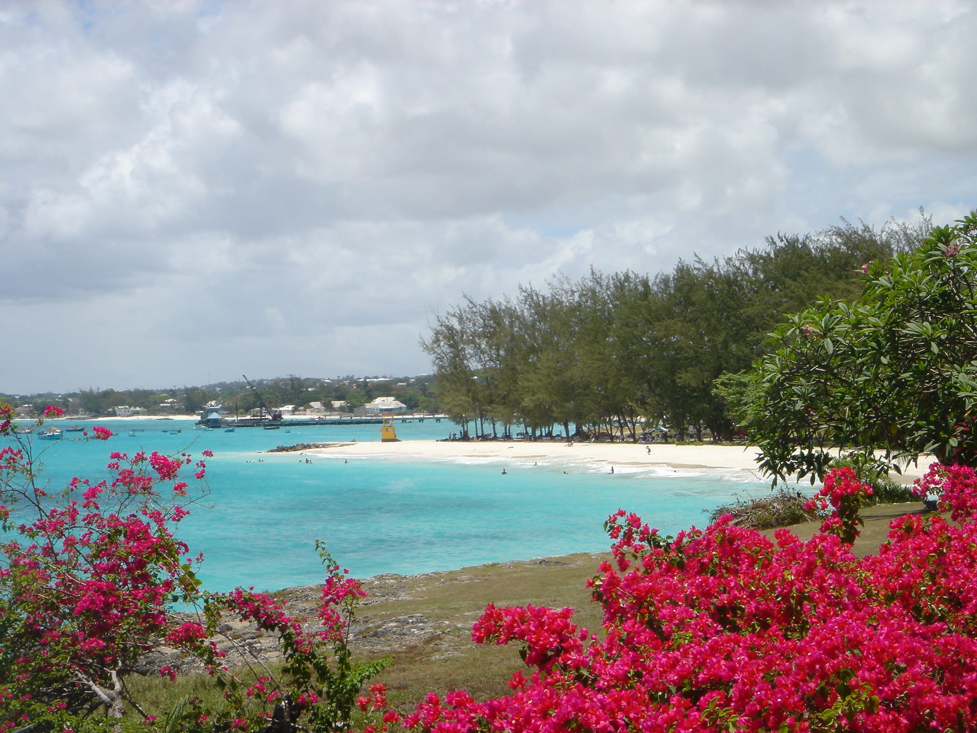
Turquoise water and a white sand beach lined with casuarina trees near Oistins, with pink bougainvillea in front

Barbados

Oistins

Miami Beach, just east of Oistins on the south coast of Barbados, seen from Enterprise Coast Road. (The original uploader was ROxBo at English Wikipedia. / Wikimedia Commons · Public domain)

The parish capital of Christ Church, midway along the parish's coast in the south of Barbados — a fishing village where boats unload their catch at the market, and where locals and visitors gather each Friday night for its fish fry. Calm beaches lie on either side, and the busy hotel strip of the south coast begins just to the west.

Neighbourhoods

  • Oistins village and waterfront
    • Best for food
    • Local life
    • Nightlife

    The fishing village around the bay, where boats unload at a jetty by the market and the food stalls of the Friday fish fry stand. Rum shops, bars, shopping arcades and the parish church are close by along Highway 7.

    Open in Maps
  • Enterprise and Miami Beach
    • Beaches
    • Families
    • Quiet and residential

    The quieter coast just east of the village, with the sheltered family bay of Enterprise Beach and the longer sweep of Miami Beach, a favourite local hangout where older residents swim and exercise each morning.

    Open in Maps
  • Saint Lawrence Gap
    • Nightlife
    • Beaches
    • Hotels and restaurants

    A 1.5-kilometre stretch of bars, restaurants, dance clubs and shops on a white-sand beachfront between Oistins and Worthing to the west, known as 'the Gap' and the main party zone of the south coast.

    Open in Maps

Things to do

Food and nights out

  • Oistins Friday fish frymarket

    On Friday nights, and more quietly on Saturdays, locals and visitors crowd the waterfront stalls for fried fish meals, local crafts and loud music — a 'lime', or social gathering, as much as a meal.

    Open in Maps
  • Saint Lawrence Gapneighborhood

    The south coast's main party strip, with a boardwalk, bars and clubs along the beach a short way west.

    Open in Maps

Beaches

  • Miami Beachbeach

    A sandy beach with usually calm water and sunset views, popular with locals and visitors, with the sheltered family cove of Enterprise Beach on its north side.

    Open in Maps
  • Plane spotting on Oistins beachviewpoint

    The beach lies under the usual approach path to Grantley Adams International Airport, so it is a popular place for watching aircraft come in.

    Open in Maps

Short trips from the town

  • Garrison Historic Arealandmark

    The old British military district on the edge of Bridgetown, with its racecourse on the former parade ground, barracks and the Barbados Museum.

    Open in Maps

Seasonal events

  • Oistins Fish FestivalEaster

    A folk festival held every Easter since 1967 to honour the people of the fishing industry, with arts and crafts, a greasy-pole climbing contest, and fish, fish cakes, pudding and souse.

Eat and drink

Long-standing places and food districts in Oistins. Hours, ratings and directions come from your maps app, always current.

Oistins classics

  • Oistins fish frymarket

    Beach huts and stalls cook fish brought straight off the boats, served as fish dinners; Friday is the big night.

    Open in Maps
  • Saint Lawrence Gap restaurantsneighborhood

    The Gap's bars and restaurants are most concentrated at its western end, with food kiosks at Dover Beach.

    Open in Maps

Experience Oistins

History

The name Oistins is thought to be a corruption of "Austin's", after an early landowner whom Richard Ligon, one of the first historians of Barbados, described as "a wild, mad, drunken fellow whose lewd and extravagant carriage made him infamous in the island". The name Oistin is also known in Irish and Scottish Highland history, and is probably a Gaelic form of the Norse name Thorstein.

The town is known for the charter often called the Treaty of Oistins, thought to have been signed at the site of the Mermaid's Inn on 17 January 1652. It brought a formal end to fighting between the colonists of Barbados and the English Commonwealth, a dispute over, among other demands, the island's right to trade with the Spanish-controlled Netherlands. After a flood in 1669 destroyed the parish church near Dover, the main church of Christ Church moved to Oistins, which became the parish capital; the town was later also home to the parish's district hospital and a coast guard station, both now closed.

Oistins became a fishing village but never a port for long-distance shipping. Many workers on Gerald Bull's Project HARP, a research project, lived around the town and the nearby airport. Towards the end of the 20th century it became a tradition for visitors to join locals at the Friday fish fry.

Culture & Customs

Fishing is the heart of Oistins' identity. The Oistins Fish Festival, held every Easter since 1967, honours the people of the fishing industry with arts and crafts, a greasy-pole climbing competition and plenty of fish, fish cakes, pudding and souse. The festival's organisers have decided to change its name, so it may appear under a new title.

The weekly fish fry is the town's other great institution. On Friday nights, and a little more quietly on Saturdays, locals and tourists sit together at long tables over fried fish meals while stalls sell local crafts and loud music plays. It is the classic Bajan "lime" — a social gathering where talk, rum and music matter as much as the food, shared by Bajans and visitors alike.

The beaches around the town are as much for residents as for visitors. Miami Beach is known as a local hangout, and older residents swim and exercise there each morning. Aircraft landing at the airport pass low overhead, and plane spotters gather on the beach to watch them.

Daily Life

Oistins is a coastal area rather than a large town: a working fishing village alongside a tourist area of bars, rum shops and shopping arcades, and the capital of Christ Church, the parish along the island's south coast. Christ Church also contains the airport and Saint Lawrence Gap, the main party zone of the south coast.

Much daily work is tied to the sea and to visitors. Fishing boats unload at a jetty by the market, and fish is prepared and cooked by the beach; supermarkets in the town serve the surrounding neighbourhoods; and the hotels, restaurants and bars of the south coast employ many local people. The town is also a small port, with an offshore landing where tankers deliver fuel to the island.

Highway 7, the main road along the south coast, is the town's lifeline and its daily problem: minibuses run constantly between Oistins and Bridgetown, and traffic is heavy through the chain of coastal villages — Hastings, Worthing, Rockley and Saint Lawrence — that link the two. The beaches nearby have faced erosion, and Miami Beach has been the focus of work by the island's coastal authorities to let it recover.

Food

Fish is the point of Oistins. Fish straight off the boats is prepared and cooked by the beach, and at the Friday fish fry the stalls serve fried fish meals. The island's own catches feature: flying fish, once so plentiful that Barbados is called "the land of the flying fish", is the base of the national dish, cou-cou and flying fish, in which a smooth cornmeal-and-okra mash comes with flying fish, fried or steamed, and a spicy gravy.

Other Bajan staples appear at the stalls and in the town's rum shops: fish cakes, macaroni pie, rice and peas, and pudding and souse — a spiced sweet-potato pudding served with pickled pork. Cutters, sandwiches in a bread roll, are the everyday quick lunch, and Bajan pepper sauce is on every table.

To drink there is rum, beer, rum punch and local soft drinks such as mauby, a bittersweet bark infusion, and sorrel. For more choice, the restaurants and bars of Saint Lawrence Gap lie a short ride west along the coast, with food kiosks at Dover Beach.

Planning tools

Budget

The south coast is livelier and cheaper than the west coast, and Oistins is one of the best-value places on the island to eat: the fish fry is the island's classic good, inexpensive meal. Buses and minibuses along Highway 7 cost little; hotel rooms on the beach strip vary widely.

Daily Budget Midrange
USD 200–350 (south-coast hotel, restaurant dinners, a catamaran or dive trip)
Daily Budget Shoestring
USD 90–140 (guesthouse, buses and minibuses, fish-fry dinners and local food)

Buses reach the Friday fish fry cheaply from anywhere on the south coast.

Best Time to Visit

Mid-December to April has the driest weather and the busiest season; Easter brings the Oistins Fish Festival. Late April to June is a good-value shoulder, and the wetter months from June to November are the quietest and cheapest. The fish fry runs all year.

Suggested Number of Days

Oistins itself needs little time beyond a Friday night, but it makes a good base on the south coast for a longer beach stay; the number of days depends on how much of the rest of the island is explored.

First Visit
2–3 days
With Surroundings
5–7 days

Transportation

Highway 7 runs along the south coast from Bridgetown through Saint Lawrence Gap to Oistins, and almost every eastbound bus goes there. Privately run minibuses shuttle constantly between Bridgetown and Oistins, stopping wherever passengers wave, and some buses run through to Speightstown in the north without changing.

Minibuses sound their horns to attract passengers; traffic drives on the left and the coast road is often congested.

Airport & Station Connections

Grantley Adams International Airport is close by to the east — the beach lies under its approach path — and taxis are the quickest way to the town; some buses also link the airport with Oistins. From Bridgetown, buses and minibuses run along the south coast.

Walkability

The village, the fish fry and the beaches nearby are easy to reach on foot. Highway 7 is busy, so minibuses are the easier way to travel along the coast to Saint Lawrence Gap and beyond.

Safety

Barbados is one of the safer Caribbean destinations, with a stable society and low levels of violent crime affecting tourists, though gang- and gun-related crime has risen in specific residential areas of and around Bridgetown that visitors have no reason to enter. The fish fry is busy and good-natured, and the south coast's sea is generally calm.

Watch belongings in the Friday crowds, use taxis or busy buses late at night, avoid isolated beaches and unlit areas after dark, and be firm with persistent beach vendors. Check current official travel advice before travelling.

Climate

Tropical and warm all year, steadied by the trade winds. The dry season runs roughly December to May; June to November is wetter and more humid and coincides with the Atlantic hurricane season.

Summer
June to November — across the island hotter than the dry season's 26–29°C and more humid, with short heavy downpours
Winter
December to May — across the island days are around 26–29°C, with low rainfall and a steady breeze

Local Customs

English is the official language, and Bajan creole is widely spoken. A 'lime' is a relaxed social gathering, and the fish fry is the classic one: shared tables, music and conversation. Greetings matter — a 'good evening' before ordering is the polite start.

Beachwear is for the beach — cover up at the stalls and in shops. Ask before photographing fishermen and vendors.

Common Payment Methods

The currency is the Barbadian dollar, pegged to the US dollar at roughly two to one, and US dollars are widely accepted, often with change given in local money. Cash in small local notes is the easiest way to pay at the fish-fry stalls and on buses; cards are accepted in hotels, supermarkets and larger restaurants.