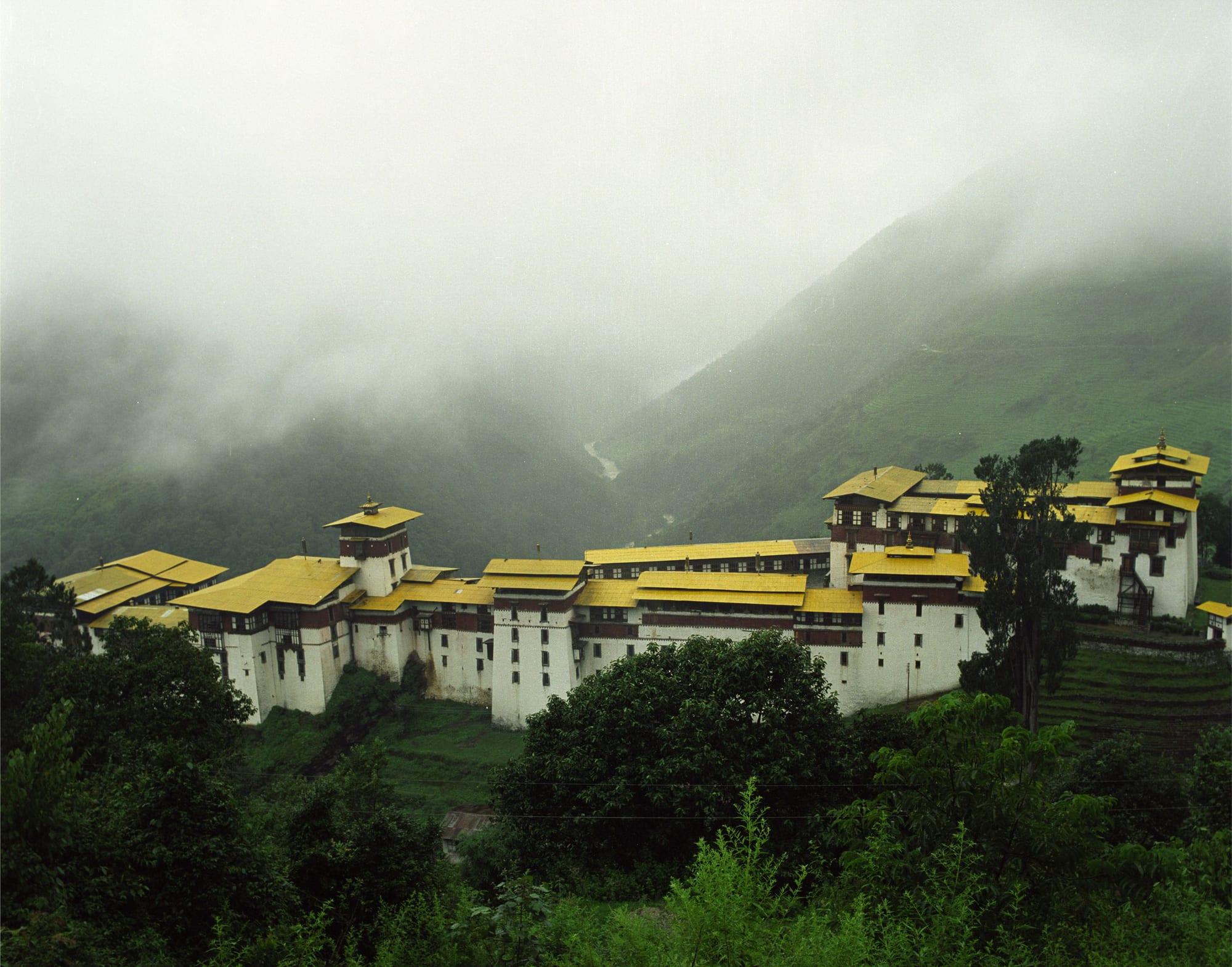
A long white fortress with yellow roofs stepping down a green ridge, with cloud filling the valley behind it

Bumthang & Central Bhutan, Bhutan

Trongsa

Trongsa Dzong on its ridge above the Mangde Chhu, with cloud across the valley. (Christopher Fynn / Wikimedia Commons · CC BY-SA 3.0)

A small hillside town in central Bhutan, strung along the lateral road above the gorge of the Mangde Chhu at about 2,200 metres. Trongsa exists because of its dzong, the largest in the country, which controlled the east–west route across the country and whose governors became the kingdom's first kings.

Neighbourhoods

  • The main street
    • First-time visitors
    • Shops and services

    A short row of shops, offices and simple restaurants along the highway above the dzong, with a small vegetable market and the bus stop. It is the whole of the town's commercial life and is walked end to end in a few minutes.

    Open in Maps
  • The dzong and the watchtower slope
    • Historic district
    • Views over the gorge

    Below the road the dzong steps down a long spur in a sequence of courtyards and temples, with the round five-storey watchtower, now a museum of the monarchy, on the hillside above it. Paths between the two look straight down into the Mangde Chhu gorge.

    Open in Maps
  • The road out to the Pele La
    • Hotels
    • Quiet and residential
    • Mountain views

    West of town the highway climbs past guesthouses, farmhouses and forest towards the pass, giving the classic distant view of the dzong across the gorge from a roadside viewpoint.

    Open in Maps
  • The lower valley
    • Farm country
    • Villages

    South of the town the land drops steeply towards warmer country, with maize and rice terraces, scattered hamlets and the road that eventually reaches Zhemgang and the southern foothills.

    Open in Maps

Things to do

The dzong

  • Trongsa Dzonglandmark

    The largest dzong in Bhutan, a maze of courtyards, temples and offices stepping down a ridge above the river, built from 1644 on the spur where a temple had been founded in 1543.

    Open in Maps

Short trips from the town

  • Chendebji Chortenlandmark

    A white stupa in the Nepali style with painted eyes, beside the river about 40 kilometres west on the road to the Pele La, built in the 18th century to subdue a local demon.

    Open in Maps
  • Jigme Singye Wangchuck National Parkpark

    The protected forests of the Black Mountains west of Trongsa, crossed by the road to the Pele La, holding tigers, red pandas and a wide range of birdlife.

    Open in Maps
  • Jakar Dzonglandmark

    The fortress above Bumthang's main town, about two hours east over the Yotong La, at the entrance to the valleys of Bhutan's oldest temples.

    Open in Maps
  • Wangdue Phodrang Dzonglandmark

    The fortress on a ridge above the Punatsangchhu, west over the Pele La on the road towards Punakha, destroyed by fire in 2012 and rebuilt in traditional technique.

    Open in Maps

Seasonal events

  • Trongsa Tshechuwinter, December or January

    The district's main festival, several days of masked religious dance in a courtyard of the dzong, held in the cold months when the valley's families can gather.

  • LosarFebruary or March

    Bhutanese New Year, marked with family meals, temple offerings and archery matches in the villages along the valley.

Eat and drink

Long-standing places and food districts in Trongsa. Hours, ratings and directions come from your maps app, always current.

Where Trongsa eats

  • Main street restaurantsneighborhood

    A handful of plain dining rooms above the dzong serve red rice with ema datshi, potato and cheese dishes, dried pork and momos, with Indian and Nepali plates for drivers on the lateral road.

    Open in Maps
  • Trongsa vegetable marketmarket

    A small market selling chillies, greens, potatoes, cheese and butter from the surrounding farms, with maize and oranges brought up from the warmer land to the south.

    Open in Maps
  • Hotel dining rooms on the Pele La roadneighborhood

    The guesthouses west of town cook set Bhutanese meals of rice, cheese-and-chilli dishes and vegetables for the travellers who break the long drive here.

    Open in Maps

Experience Trongsa

History

Trongsa's story begins with a hermitage. In 1543 the Drukpa lama Ngagi Wangchuck is said to have built a small temple on the spur above the Mangde Chhu, and a settlement grew around it — the name is usually explained as "new village". In 1644 the Zhabdrung Ngawang Namgyal's government began the fortress that became Trongsa Dzong, and successive rulers enlarged it into the largest dzong in the country, a chain of courtyards and temples following the shape of the ridge.

Position gave it power. Before modern roads, the east–west route across Bhutan ran past the dzong, which controlled the country's trade for centuries, so whoever held Trongsa held the traffic between the two halves of the kingdom. Its governors, the Trongsa Penlops, became the most powerful officials in the kingdom. In the 19th century Jigme Namgyal, the Penlop known as the Black Ruler, fought the British in the Duar War and rose to become Druk Desi, and his son Ugyen Wangchuck, also Penlop of Trongsa, was chosen as the first hereditary king of Bhutan in 1907. Each crown prince is still invested as Penlop of Trongsa before taking the throne.

The dzong has been damaged and rebuilt repeatedly, most seriously after an earthquake in 1897. The second king used Kuenga Rabten, south of the town, as a winter palace in the early 20th century. The lateral road, built from the 1960s, brought the modern town into being as a line of shops above the fortress, and the watchtower was converted into a museum of the monarchy which opened in 2008.

Culture & Customs

Trongsa is a place of national ceremony more than of local spectacle. The dzong holds the district administration and a large monk body, and its link to the royal family gives the town a formality that its size would not otherwise explain: investitures, state visits and the winter tshechu all take place within its walls. The Ta Dzong museum tells the same story, with the possessions of the first kings and the religious objects of the Penlops.

Daily culture is that of central Bhutan. National dress is worn to offices and into the dzong, with the kabney scarf for men and the rachu for women; the Bumthangkha and Khengkha languages of the neighbouring valleys are heard alongside Dzongkha; and the village calendar turns on local temple rituals, house consecrations and the annual choku ceremonies held by families. Archery is played on the flat ground that can be found, which in this landscape is scarce.

The town lives with the road. Almost every vehicle crossing Bhutan stops here, and Trongsa functions as a gate and a resting place, with the pace and the mixed company of a highway town — drivers, monks, officials, traders from the south and a steady trickle of visitors. Residents tend to be reserved and matter-of-fact, and the dzong remains the reference point for everything: directions, work, worship and the town's sense of itself.

Daily Life

Trongsa district holds only a small share of Bhutan's population, and the town itself a few thousand people, making it one of the smallest of Bhutan's district centres. The dzong provides much of the formal employment, with the district administration, courts, monk body and schools, and the rest comes from shops, guesthouses, road maintenance and transport.

Farming supports most families outside the town. On the higher ground it is potatoes, wheat, barley and vegetables with cattle for milk and butter; further down the slopes, where the valley falls towards Zhemgang, maize, rice, oranges and areca nut grow in a warmer climate. Households divide work between fields, livestock and, increasingly, a wage job in the town.

The rhythm is quiet. Shops open in the morning, the market handles the day's produce, and the street is dark and largely empty by early evening, when traffic on the highway drops away. Concerns are those of rural Bhutan: the cost of transport over two high passes, patchy mobile and internet coverage in the side valleys, young people leaving for Thimphu or abroad, and the effect of hydropower construction on the Mangde Chhu, which has brought work, traffic and change to the valley below the dzong.

Food

Trongsa eats the cooking of central Bhutan, adjusted to what the steep land produces. Red or white rice is served with ema datshi, whole chillies stewed with soft local cheese, and its variations — kewa datshi with potatoes and shamu datshi with mushrooms — with dried beef or sikam, dried pork belly, cooked with chillies and radish when there is meat. Maize, grown on the lower slopes, appears as kharang, cracked maize cooked like rice, and as porridge in village kitchens.

Buckwheat dishes from Bumthang, puta noodles and khule pancakes, are common on menus here, since the valleys are only a pass apart. Wild foods matter in season: ferns and nakey shoots in spring, mushrooms after the monsoon, and bamboo shoots from the forests to the south, often cooked with cheese or dried pork. Oranges from the warmer land below the town are sold along the highway in winter.

Drinks follow the national pattern. Suja, tea churned with butter and salt, is offered at any hour, sweet milk tea is drunk with snacks, and ara, the home-brewed grain spirit, is made from rice, maize or wheat and served to guests and at festivals. Doma, areca nut with betel leaf and lime, is chewed widely. Eating out means the plain restaurants on the main street or a set meal in one of the guesthouses on the road towards the pass.

Planning tools

Budget

Costs follow national policy rather than local prices: most visitors pay the Sustainable Development Fee of USD 100 per person per night on top of accommodation, food and transport, and many book through a licensed Bhutanese operator who provides guide and driver. Trongsa has no luxury hotels, and lodging is in mid-range guesthouses along the road, so the daily total is at the lower end of the Bhutanese range.

Daily Budget Midrange
USD 400–500 (the fee, a mid-range guesthouse, guide and driver, restaurant meals and small purchases)
Daily Budget Shoestring
USD 300–380 (the nightly Sustainable Development Fee, a simple guesthouse, canteen meals and shared transport)

Spending money goes on handicrafts, textiles and tips; visitors from India travel under separate, much cheaper rules.

Best Time to Visit

Autumn, from late September to November, gives the clearest views of the dzong from across the gorge, and spring brings rhododendron on the road to the Pele La. Winter is cold but bright, with the district's festival in the dzong. The monsoon months from June to August are cloudy and wet, with landslides possible on the roads either side of the town.

Suggested Number of Days

Most visits amount to one day, or an overnight stop between the western valleys and Bumthang. Two days allow the country south and west of the town at a slower pace. Long drives in and out shape the total more than the town itself.

First Visit
1 day
With Surroundings
2 days

Transportation

Everything lies along the lateral highway and the lanes dropping to the dzong. Tourist travel is normally in the operator's vehicle with a driver, which is also how the sights outside town are reached; buses and shared taxis run along the highway between Wangdue Phodrang and Bumthang. There is no local transport within the town.

Stop at the viewpoint west of the town for the long view of the dzong across the gorge, which cannot be seen from beside the building itself.

Airport & Station Connections

Trongsa sits at the middle of Bhutan's lateral road, a long day's drive from Thimphu or Punakha over the Pele La at about 3,400 metres, and about two hours west of Jakar in Bumthang over the Yotong La. The nearest airfields are Bathpalathang in Bumthang, with domestic flights, and Paro International Airport far to the west.

Walkability

The town is a single street and is walked in minutes, but everything around it is steep. The dzong lies well below the road and the watchtower well above it, so moving between them means a stiff climb, and the hillside lanes are narrow and without pavements. Walking on the highway itself is uncomfortable because of traffic.

Safety

Trongsa is very safe, and crime is rare. The real risks are the mountain roads, with rockfall, landslides in the monsoon and ice on the passes in winter, steep unfenced drops around the dzong and the gorge, and the distance from a well-equipped hospital.

Keep well back from unfenced edges above the gorge, allow generous time for road delays, and carry warm clothing for the passes. Check current official travel advice before travelling.

Climate

A temperate mountain climate, milder than Bumthang but often wrapped in cloud, with heavy monsoon rain and mist rising from the gorge. Clear days in autumn show the whole ridge and the mountains behind it.

Summer
mild and very wet — June to August days are generally 18–24°C, with long spells of cloud and rain
Winter
cold and mostly dry — December to February days reach about 10–14°C, with frost at night and snow on the passes

Local Customs

The dzong is a working monastery and the district's administrative seat: modest dress with covered arms and legs is required, shoes come off at shrine doors, and much of the building is closed to visitors. Walk clockwise around chortens and temples. The town has a strong sense of the monarchy's history, and the crown prince still becomes Penlop of Trongsa before taking the throne.

Ask before photographing people or monks, and do not photograph inside shrines or the museum's display rooms unless told it is allowed.

Common Payment Methods

The currency is the ngultrum, pegged one to one with the Indian rupee, which also circulates. There is a bank and an ATM in the town, but machines can be out of cash and cards are rarely accepted outside hotels, so notes are needed for shops, the market and offerings. Residents increasingly pay one another by mobile QR code.