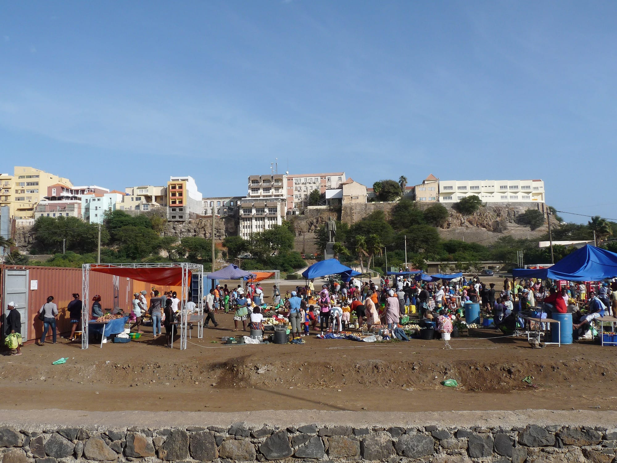
Pastel buildings standing along the rim of a flat-topped cliff above Praia, with market stalls and shade canopies on the open ground below

Cabo Verde

Praia

The Plateau, the old centre of Praia, seen from the market ground below its escarpment. (Ji-Elle / Wikimedia Commons · CC BY-SA 3.0)

The capital of Cabo Verde, on the southern coast of Santiago, built on a flat-topped sea cliff known as the Plateau that became the capital in 1770 after the decline of nearby Cidade Velha. It is the country's largest city and its administrative and commercial hub, spreading inland from the old centre over a ring of hills and bays.

Neighbourhoods

  • Plateau
    • First-time visitors
    • Historic district
    • Close to public transport

    The old colonial centre on its flat-topped cliff, laid out on a grid around the Praça Alexandre Albuquerque with the presidential palace, ministries, banks, the old town hall and the ethnographic museum. Shops and cafés line the main streets and the escarpment gives views over the bays on either side.

    Open in Maps
  • Achada Santo António
    • Best for food
    • Quiet and residential

    A newer district on the plateau south-west of the centre, with embassies, offices, apartment blocks, restaurants and supermarkets. It is where many better-off residents and foreign workers live, and where much of the city's evening eating out happens.

    Open in Maps
  • Prainha and Quebra Canela
    • Beaches
    • Quiet and residential

    The coastal strip south-west of the centre, with the city's two main beaches, hotels and villas on the slopes behind. Quebra Canela's sheltered sand is the city's weekend gathering place.

    Open in Maps
  • Sucupira and Fazenda
    • Markets
    • Local life

    The busy commercial ground immediately below the Plateau, dominated by the sprawling Sucupira market and the bus and van stands around it. Crowded, loud and the place where much of the city actually shops.

    Open in Maps
  • Achadas and the eastern hills
    • Local life

    The dense residential quarters that climb the hills around the centre, such as Achada Grande to the east and Achadinha to the north-west, grown rapidly with migration from the countryside. Largely residential, with neighbourhood markets and churches.

    Open in Maps

Things to do

The old centre

  • Plateauneighborhood

    The colonial-era heart of the capital on its cliff top, with pastel administrative buildings, a shaded central square and a grid of streets that can be walked in an hour.

    Open in Maps
  • Palácio da Presidêncialandmark

    The presidential palace at the southern end of the Plateau, a neoclassical building of around 1894 built as the residence of the Portuguese governor and taken over by the presidency after independence in 1975.

    Open in Maps
  • Museu Etnográfico da Praiamuseum

    A small ethnographic museum opened in 1997 in a nineteenth-century building on the Plateau, with objects showing the traditional ways and customs of Cabo Verdeans.

    Open in Maps
  • Sucupira Marketmarket

    The city's large open-air market below the Plateau, selling clothing, household goods, tools, fruit and vegetables.

    Open in Maps

Beaches

  • Quebra Canelabeach

    The popular city beach in the district of the same name south-west of the centre, busy at weekends and in the evening.

    Open in Maps
  • Prainhabeach

    A smaller beach beside Quebra Canela, in the district of hotels and embassies of the same name.

    Open in Maps
  • Gamboabeach

    The beach immediately below the Plateau on its southern side, beside the old port, and the site of the annual Festival de Gamboa music festival.

    Open in Maps

Short trips

  • Cidade Velhalandmark

    The first European town in the tropics, about 10 km west, a UNESCO World Heritage Site since 2009, with a sixteenth-century pillory in its square and a ruined cathedral above the shore.

    Open in Maps
  • Fortaleza Real de São Filipelandmark

    The hilltop fort above Cidade Velha, built between 1587 and 1593 after Francis Drake's raid of 1585, with walls, a cistern and a view down the coast.

    Open in Maps
  • Igreja de Nossa Senhora do Rosáriolandmark

    A church in Cidade Velha built in 1495, the town's oldest surviving building and described as the oldest colonial church in the world.

    Open in Maps
  • Assomadamarket

    The main town of Santiago's interior, about 26 km north-west, whose market, founded in 1931, is one of the largest on the island, with farm produce and crafts.

    Open in Maps
  • Serra Malaguetapark

    A mountain range about 35 km north-west, protected as a natural park since 2005 and rising to 1,064 m, the highest point of northern Santiago, with walking trails among endemic plants.

    Open in Maps
  • Tarrafalattraction

    A fishing town with a sheltered palm-backed beach, and the site of a camp used by the Portuguese authorities from 1936 until 1974 to hold political prisoners, now preserved as a museum.

    Open in Maps

Getting around

  • Nelson Mandela International Airporttransit hub

    The capital's international airport, opened in 2005 about 3 km north-east of the city centre, handling international flights and domestic services.

    Open in Maps

Seasonal events

  • Gamboa FestivalOnce a year

    An annual music festival staged on Gamboa beach below the Plateau.

  • CarnivalFebruary or March

    Parades of costumed groups and drumming through the Plateau and the surrounding districts in the days before Lent.

  • Tabanka seasonMay to July

    Processions of Santiago's tabanka groups on holy days, with drums and conch horns, a tradition whose groups also act as mutual-aid associations.

Eat and drink

Long-standing places and food districts in Praia. Hours, ratings and directions come from your maps app, always current.

Praia classics

  • Cachuparestaurant

    Santiago's version of the national stew, made with hominy corn, beans, cassava, sweet potato and pork or tuna, and fried the next morning with an egg.

    Open in Maps
  • Grilled fish and lobsterrestaurant

    Tuna, other fish and lobster landed along the Santiago coast, grilled and served with rice, beans and salad.

    Open in Maps
  • Xerémrestaurant

    A coarse maize porridge, served with fish or meat, from the farming kitchens of Santiago's interior.

    Open in Maps

Markets and food districts

  • Sucupira Marketmarket

    The city's largest market, an open sprawl of stalls below the Plateau where most of Praia buys clothing, produce and household goods.

    Open in Maps
  • Achada Santo António restaurantsneighborhood

    The district where most of the capital's sit-down restaurants, pizzerias and bars are concentrated, along with cafés used for business lunches.

    Open in Maps

Experience Praia

History

Praia grew up in the shadow of Ribeira Grande, now Cidade Velha, the first European town in the tropics, founded on this coast in 1462 and enriched by the Atlantic slave trade. Repeated raids on that exposed harbour — among them Francis Drake's in 1585 and Jacques Cassard's in 1712 — pushed settlement eastwards to a defensible flat-topped cliff above a sheltered bay. A settlement grew on this Plateau, gradually superseded the old town, and became the capital of the Portuguese colony in 1770; in 1858 it was formally made a city.

The nineteenth-century town on the Plateau took the shape it still has: a grid of streets around a central square, with the governor's palace, the customs house, the barracks, the church and the merchants' houses. Growth was slow, checked by the droughts and famines that repeatedly devastated Santiago and drove emigration, and the port never rivalled Mindelo's coal trade.

Independence in 1975 made Praia a national capital, and the city expanded dramatically as people moved in from the interior of Santiago and the other islands. Ministries, the university, banks and the airport turned it into the country's administrative and commercial centre, and its population has multiplied several times over since the 1970s. Development has spread across neighbouring plateaux and ravines, often faster than services could follow, and the city remains a place of rapid, uneven growth.

Culture & Customs

Praia's culture is strongly African-rooted, and it reflects the badiu identity of Santiago, one of the islands that received enslaved people directly from the West African mainland. Batuque, in which women beat rolled cloth on their laps and sing call-and-response verses of social commentary, and the finaçon chant that accompanies it, belong to this island, as does funaná, the accordion-driven dance music once discouraged by the colonial authorities and now heard everywhere.

The tabanka groups of Santiago, with their processions of drums and conch horns on holy days from May to July, also act as mutual-aid associations and remain a living tradition in villages around the capital. Catholicism and the saints' days structure the year.

As a capital the city is also the country's political and intellectual centre, with the parliament, the university and the national press. Its population is mixed — people from every island, plus West African traders, Chinese shopkeepers and Portuguese and Brazilian residents — and street life is louder, faster and less picturesque than in Mindelo, a contrast that Cabo Verdeans discuss endlessly and with some humour.

Daily Life

Around 160,000 people live in Praia, and its municipality holds more than a quarter of the national population; the wider urban area keeps growing as people arrive from Santiago's interior and the smaller islands. The Plateau is for work rather than living; most residents are in the achadas, the flat-topped hills around it, in a mixture of planned districts and self-built neighbourhoods.

The city runs on government, services and trade: ministries and the parliament, banks and telecoms, the university and technical colleges, the port, the airport, construction and a very large informal economy of market stalls and street vendors, much of it run by women. Fishing works from the coastal villages, and produce comes in daily from the island's interior valleys.

The day begins early and the Plateau empties in the evening when offices close, while the residential districts and the beaches fill. About a third of the city's people lived below the poverty line in 2014, traffic is heavy on the few roads linking the plateaux, and youth unemployment, housing and crime are the issues that dominate local politics.

Food

Praia's food is Santiago's: heavier on maize, beans and pork than the northern islands, and closer to West African cooking. Cachupa, the national dish, is cooked here in its rich version with pork, sausage and several kinds of bean, and eaten again the next morning fried with an egg. Xerém, a coarse maize porridge served with fish or meat, is the other island staple, and each island has its own way with cachupa.

The coast supplies tuna, octopus and lobster, grilled or stewed with tomato and onion. Pastéis, fried pastries filled with fish or meat, are a common snack at market stalls and roadside stands, along with grilled maize cobs in season.

Fruit and vegetables from the interior valleys arrive daily at the city's markets, above all the Sucupira. To drink there is grogue, the sugarcane spirit distilled in Santiago's valleys and in Santo Antão, taken neat or as ponche, sweetened with cane molasses or condensed milk, alongside local beer, imported wine and strong coffee.

Planning tools

Budget

Praia is a working capital rather than a resort, and costs reflect that. Hotels are aimed at business travellers and government visitors and are the main expense; eating in local restaurants, buying at the markets and using shared vans are inexpensive. Day trips to Cidade Velha and the island's interior, and domestic flights onward, are the other significant costs.

Daily Budget Midrange
USD 90–170 (hotel room, restaurant meals, taxis and a car or driver for island trips)
Daily Budget Shoestring
USD 35–60 (guesthouse or residencial room, local food, shared aluguer vans)

Rooms fill and prices rise when conferences and official events are in town; the Plateau, the beaches and the markets cost nothing to explore.

Best Time to Visit

November to June is dry, sunny and warm, with the coolest and clearest conditions between December and March. August to October is hotter and more humid and carries the year's rain, which greens Santiago's interior and makes the mountains around Serra Malagueta worth walking.

Suggested Number of Days

Two days is enough for the capital itself, which is more a place of business than of sights. Four or five allows the World Heritage town down the coast, the market towns and mountains of the interior and the north of Santiago. Transport times, not distances, set the pace.

First Visit
2 days
With Surroundings
4–5 days

Transportation

Shared aluguer vans and small buses cover the city and run from stands near the Sucupira market to towns across Santiago, leaving when full. Taxis are cheap and plentiful in the capital. Hire cars are available for the island's mountain roads, which are winding and in places cobbled, and driving after dark outside town is best avoided.

Vans to the interior leave from the stands below the Plateau; for Cidade Velha and Tarrafal it is worth starting early, as services thin out in the afternoon.

Airport & Station Connections

Nelson Mandela International Airport is about 3 km north-east of the Plateau, ten minutes by taxi, with international flights and the main domestic network to the other islands. Ferries from Praia's port run directly to Maio, Fogo and São Vicente, slowly and with sailings that change at short notice.

Walkability

The Plateau is walkable and pleasant: a compact, level grid of streets, with the main square, the palace and the museum inside it. Everything else involves steep slopes, busy roads and long distances, since the city is spread over several plateaux separated by ravines. Walking between districts at night is not usual, and taxis are used instead.

Safety

Petty theft is the main concern in Praia, and bag-snatching, pickpocketing and occasional muggings are the main risks, above all after dark, in quiet streets of the Plateau once offices close, around the markets and on unlit beaches. Violent crime is low by regional standards.

Keep valuables out of sight, avoid quiet urban areas of Praia after dark, and ask locally about currents before swimming off unpatrolled beaches. Check current official travel advice before travelling.

Climate

Hot semi-desert climate cooled by the trade winds. Rain is scarce and confined mostly to August, September and October, when short heavy downpours can flood ravines; the rest of the year is dry and sunny, with Saharan dust sometimes hazing the air in winter.

Summer
August to October is the warmest and most humid, around 28–30°C by day, with the year's rain
Winter
December to March is dry and breezy at around 24–26°C, with cooler nights

Local Customs

Portuguese is the official language and the Santiago variety of Cabo Verdean Creole, badiu, is the language of daily life; French and English are less common than in the resort islands. Greetings precede any request, and dress in the capital is neat — beachwear stays on the beach and shoulders are covered in churches. Batuque and tabanka, the island's African-rooted music and mutual-aid traditions, are sources of local pride.

Ask before photographing people, particularly market traders and at religious processions, and do not photograph government or military buildings.

Common Payment Methods

The currency is the Cabo Verdean escudo (CVE), pegged to the euro at about 110 to 1. Cards are accepted in hotels, supermarkets and larger restaurants in the capital, but cash is needed at markets, in vans and at small kitchens, and euros are less freely accepted here than on Sal or Boa Vista. ATMs are widespread in the Plateau and Achada Santo António.