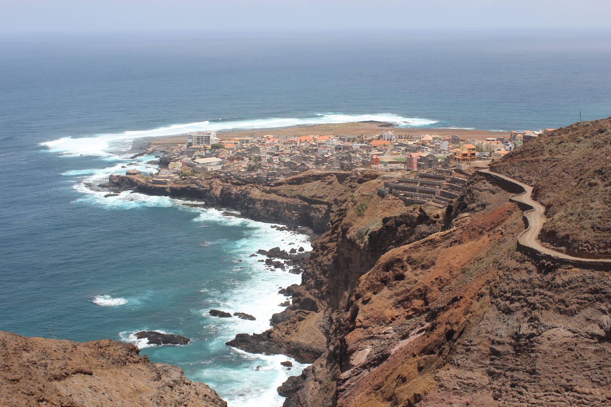
A small town on a low rocky headland with surf breaking along the cliffs, terraced fields and a road cut into the red hillside above

Cabo Verde

Santo Antão

Ponta do Sol on the northern coast of Santo Antão, seen from the cliffs above the town. (Zinneke / Wikimedia Commons · CC BY-SA 3.0)

The north-western tip of Cabo Verde and the second largest of its islands, split by a mountain spine into an arid south and a green, cloud-fed north of deep ravines and terraced fields. Reached only by ferry from Mindelo, it lives from sugarcane, coffee and grogue distilling, and is the archipelago's walking island, crossed by old cobbled paths between cliff-top villages.

Neighbourhoods

  • Ribeira Grande
    • First-time visitors
    • Local life
    • Close to public transport

    The island's historic main settlement and a city since 2010, known locally as Povoação, built near the mouth of the Ribeira Grande on the north-east coast. Its streets of shops, offices and small guesthouses run back from a bridge over the ribeira, and the shared vans that serve the northern valleys gather here.

    Open in Maps
  • Ponta do Sol
    • Quiet and residential
    • Best for food
    • Walks

    A small town on a flat headland at the island's northern tip, with a fishing harbour, a square of colonial buildings and the flat ground of a former airstrip. It is the usual base for the coastal path towards Fontainhas and Cruzinha.

    Open in Maps
  • The Paúl valley
    • Scenery
    • Walks
    • Farms and distilleries

    A steep, intensively farmed valley of sugarcane, banana, mango and coffee running down from the crater rim to the sea at Vila das Pombas. Small grogue distilleries work along it, and stone paths climb between hamlets perched on the slopes.

    Open in Maps
  • Porto Novo
    • Arrivals and departures
    • Close to public transport

    The island's largest town and its port, on the dry south-east coast facing São Vicente, where the ferry from Mindelo docks and the roads north begin. It is a working town rather than a place people stay, but it is the island's transport hub.

    Open in Maps

Things to do

Valleys and viewpoints

  • Cova craterviewpoint

    A volcanic caldera about 1 km across at the head of the Paúl valley, its floor at around 1,170 m planted with maize and beans and its rim rising to about 1,500 m.

    Open in Maps
  • Paúl valleytrail

    The island's greenest ravine, terraced from the sea to the crater rim with sugarcane, coffee and fruit, and lined with small grogue distilleries.

    Open in Maps
  • Ribeira da Torretrail

    A stream valley running inland from Ribeira Grande towards the Cova crater, farmed on a small scale for sugar cane, coffee, yams, bananas, papaya and mango, its upper reaches inside a natural park.

    Open in Maps
  • Fontainhasviewpoint

    A settlement near the rocky north coast about 2 km south-west of Ponta do Sol, taking in the small villages of Corvo and Forminguinhas, and a stop on the coastal path.

    Open in Maps

Walks

  • Ponta do Sol to Cruzinha coastal pathtrail

    An old cobbled and cut path along the north coast past Fontainhas and Corvo to the fishing village of Cruzinha da Garça, high above the surf for much of the way.

    Open in Maps
  • Estrada da Cordatrail

    The mountain road across the island's spine between Porto Novo and Ribeira Grande, passing through Corda at about 1,000 m, some 4 km from the Cova crater.

    Open in Maps
  • Tope de Coroaviewpoint

    The island's highest point at 1,979 m, a bare volcanic summit in the arid west, climbed as a long guided walk.

    Open in Maps

Towns and the coast

  • Ponta do Sol harbourlandmark

    The small fishing harbour at the island's northern tip, where boats are hauled up the slipway and the catch is sold on the quay.

    Open in Maps
  • Ribeira Grandeneighborhood

    The island's historic main settlement and seat of its first municipality in 1732, near the mouth of the Ribeira Grande, with the parish church of Nossa Senhora do Rosário and a market.

    Open in Maps
  • Porto Novo ferry porttransit hub

    The harbour on the south coast where the ferry from Mindelo arrives, the island's only regular link with the rest of the country.

    Open in Maps

Short trips

  • Tarrafal de Monte Trigoattraction

    A remote coastal settlement of about 800 people below the island's western mountains, linked to the rest of the island by a new road only in 2021.

    Open in Maps

Seasonal events

  • Festa de São João BaptistaJune

    Saint John the Baptist's day, 24 June, celebrated in Porto Novo with colá, the drumming and dancing of the island's saints' days; Pombas and Garça mark Saint Anthony and Saint Peter in the same month.

  • CarnivalFebruary or March

    Parades and music in the island's towns in the days before Lent, on a smaller scale than Mindelo across the channel.

Eat and drink

Long-standing places and food districts in Santo Antão. Hours, ratings and directions come from your maps app, always current.

Santo Antão classics

  • Cachuparestaurant

    The national stew of hominy corn and beans, cooked here with pork or tuna, and fried up the next morning with an egg.

    Open in Maps
  • Grogue and poncherestaurant

    Sugarcane spirit distilled in small valley stills, drunk neat or sweetened with cane molasses and lime into a ponche; the island's best-known product.

    Open in Maps
  • Valley producerestaurant

    Papaya, mango, banana, coffee and goat's cheese from the northern ravines appear in almost every meal, alongside fish landed at Ponta do Sol.

    Open in Maps

Where to eat

  • Ponta do Sol squareneighborhood

    The small square and seafront hold the island's best concentration of restaurants and cafés, several serving fish landed a few metres away.

    Open in Maps
  • Ribeira Grande marketmarket

    A modest municipal market for valley fruit and vegetables, fish, cheese and bottled grogue, busiest early in the morning.

    Open in Maps

Experience Santo Antão

History

Santo Antão was sighted by Portuguese navigators in the 1460s and named for Saint Anthony, but it was settled slowly, the first evidence of settlement dating from 1548. What made it valuable was water: the north-eastern valleys catch the trade-wind clouds, and their slopes were terraced into one of the few reliably productive farming landscapes in the archipelago, worked by hand because machinery cannot reach them. Sugarcane grew in the ravines, and cane spirit — grogue — became the island's characteristic product, distilled in small stills that still work today.

The island's isolation shaped everything. The dry south coast was settled late: Porto Novo was a fishing village of some 30 buildings in 1901, and its port was inaugurated only in 1962 — before then ships anchored offshore and landed goods by small boat. It has since become the island's largest town, linked with Ribeira Grande by the mountain road through Corda and with Pombas by a coast road. The Agostinho Neto Airport near Ponta do Sol was closed for safety reasons in the 1990s, leaving the ferry as the sole link.

Repeated droughts and famines drove islanders away — to Mindelo on São Vicente, which drew many of them during the famines of the mid-twentieth century, and later abroad. Emigration and remittances still shape the villages, while hiking and walking tourism has become one of the island's main industries.

Culture & Customs

Santo Antão is thought of within Cabo Verde as the country's agricultural heartland and the home of grogue, and islanders take the distinction seriously: the provenance of cane spirit is discussed here in the way wine is elsewhere, and offering a visitor a glass is a basic courtesy. The trapiche, the press that crushes the cane, is a symbol of the island, and cane cutting and distilling still organise part of the year.

Musically the island keeps colá, the drumming and dancing of the saints' days, alongside the morna and coladeira heard everywhere in the archipelago. June is the festival month: Santo António in Pombas on the 13th, São João in Porto Novo on the 24th and São Pedro in Garça on the 29th are all celebrated with colá.

Village society is tight, Catholic and built on mutual help, with families spread between the valleys and the diaspora. Manners are formal by Cabo Verdean standards: greetings on the path, respect for elders, and an expectation that visitors walking through farmland ask rather than assume.

Daily Life

About 38,000 people lived on Santo Antão in 2019, many of them in the north — in Ribeira Grande, Ponta do Sol, Vila das Pombas and the hamlets stacked up the valley sides — though Porto Novo, on the drier south coast, is the largest town. Young people continue to leave for São Vicente, Praia and abroad.

Farming is still the backbone: sugarcane for grogue, coffee in the upper Paúl valley, bananas, mangoes, papaya, cassava, yams and vegetables grown on terraces irrigated by channels from the springs, along with goats and a little cattle. Fishing works out of Ponta do Sol, Cruzinha and Tarrafal de Monte Trigo. Produce is shipped to São Vicente again since a quarantine on the island's farm exports, imposed because of a millipede pest, was lifted in 2008, and walking tourism supports guesthouses, guides and drivers in the northern valleys.

The day begins very early in the fields and ends soon after dark. Shared vans rattle down to the coast with people and produce; the ferry's arrival sets the rhythm of Porto Novo. Water management, landslides and road damage after heavy rain, and the steady loss of young people to emigration are the recurring concerns in valley conversation.

Food

Santo Antão eats more from its own land than most of Cabo Verde. Cachupa here is made with the island's own maize and beans and whatever else the terraces yield — cassava, sweet potato, squash, green banana — simmered for hours with pork or tuna and eaten again the next day fried with an egg.

The valleys supply the rest: papaya, mango, bananas, sugarcane and coffee grown high in Paúl, along with fresh goat's cheese eaten with papaya jam. Fish landed at Ponta do Sol and Cruzinha — tuna, wahoo, moray, octopus and limpets picked off the rocks — is grilled or stewed into a caldeirada. Maize also appears as xerém, a corn dish served with soup.

Grogue is the island's signature. Cane is crushed at small trapiches, fermented and distilled into a clear spirit of considerable strength, then drunk neat, mixed with cane syrup and lime as ponche, or infused with herbs such as rue, rosemary or anise. Coffee from the upper valleys, drunk strong and sweet, rounds out the local table.

Planning tools

Budget

Santo Antão is one of the cheaper islands. There are no large resorts; accommodation is guesthouses, small hotels and family-run rooms in the valleys, and meals in local restaurants cost a fraction of Sal prices. The main expenses are the ferry from Mindelo, transport around the island by shared van or hired car with driver, and a guide for the longer walks.

Daily Budget Midrange
USD 80–150 (small hotel or rural inn, restaurant meals, a hired car with driver or a guided walk)
Daily Budget Shoestring
USD 35–60 (guesthouse or residencial room, local food, shared aluguer vans)

A guide is worth the cost on the longer ravine walks, where paths fork often and route-finding is not obvious.

Best Time to Visit

October and November are the finest months for walking: the short rains, if they come, fall in late summer and autumn, and the valleys are at their greenest afterwards. December to March is dry, cool and windy, with clear air and good visibility. The late summer can be hot, humid and cloudy on the northern slopes, and heavy rain occasionally cuts tracks.

Suggested Number of Days

Three or four days allows the northern valleys and a couple of the classic walks. Walkers routinely stay a week or more, since the trail network is large and moving between valleys is slow. Ferry times mean that arrival and departure days are largely taken up by travel.

First Visit
3–4 days
With Surroundings
5–7 days

Transportation

No airport operates on the island, so everything arrives through Porto Novo. Shared aluguer vans run from the port to Ribeira Grande, Ponta do Sol and Vila das Pombas and up the main valleys, filling before they leave; hired vehicles with drivers are the usual alternative. Two main roads run north from the port — the mountain road through Corda and a coast road to Vila das Pombas — and side valleys are served by narrow, steep roads and by footpaths.

Roads are winding and exposed and journeys take far longer than the distances suggest; many of the best places are reachable only on foot.

Airport & Station Connections

Access is by sea. Ferries cross from Mindelo on São Vicente to Porto Novo four times a day, and the channel can be rough. From Porto Novo roads run over the mountains or along the coast to Ribeira Grande and Ponta do Sol. The nearest airport is at São Pedro on São Vicente, reached through Mindelo.

Walkability

The towns are small and walkable — Ponta do Sol and Ribeira Grande can each be crossed in fifteen minutes — but the island as a whole is walking country of a demanding kind. Valley paths are steep, cobbled or rough underfoot, and often narrow with long drops beside them, which needs sure footing and a head for heights rather than technical skill.

Safety

Crime is very low and the island is among the quietest places in the country. The genuine risks are in the terrain: exposed paths above sheer drops, rockfall after rain, sudden cloud on the high ground, heat and lack of water on the arid side, and narrow mountain roads with long unfenced edges. Sea swimming is limited by a strong swell and rocky shores.

Keep valuables out of sight, avoid quiet urban areas of Praia after dark, and ask locally about currents before swimming off unpatrolled beaches. Check current official travel advice before travelling.

Climate

Two climates on one island. The north-east slopes catch the trade winds and their moisture, which keeps the valleys green and frequently draws cloud over the crater rim; the south and west are arid. Rain, when it falls, comes mainly in late summer and autumn, and higher ground is noticeably cooler than the coast.

Summer
August to October is warmest and most humid, around 26–29°C on the coast, cooler and often cloudy on the ridges
Winter
December to March is dry, breezy and around 22–25°C on the coast, with cold nights on the high ground

Local Customs

Village life is close-knit and courteous: greetings are exchanged with everyone met on a path, and asking before entering fields, yards or distilleries is expected. Cabo Verdean Creole is the everyday language, with a distinct island accent, and Portuguese the official one; French is understood by some and English rarely outside guesthouses. Dress modestly away from the beaches.

Ask before photographing people, houses or work in the valleys, and accept a small glass of grogue when offered — it is the standard gesture of welcome.

Common Payment Methods

The currency is the Cabo Verdean escudo (CVE), pegged to the euro at about 110 to 1, and euros are accepted in some guesthouses but not reliably elsewhere. Cards are taken in a few hotels in Porto Novo, Ribeira Grande and Ponta do Sol; most transactions are cash. ATMs exist in those three towns only, so cash should be drawn before heading into the valleys.