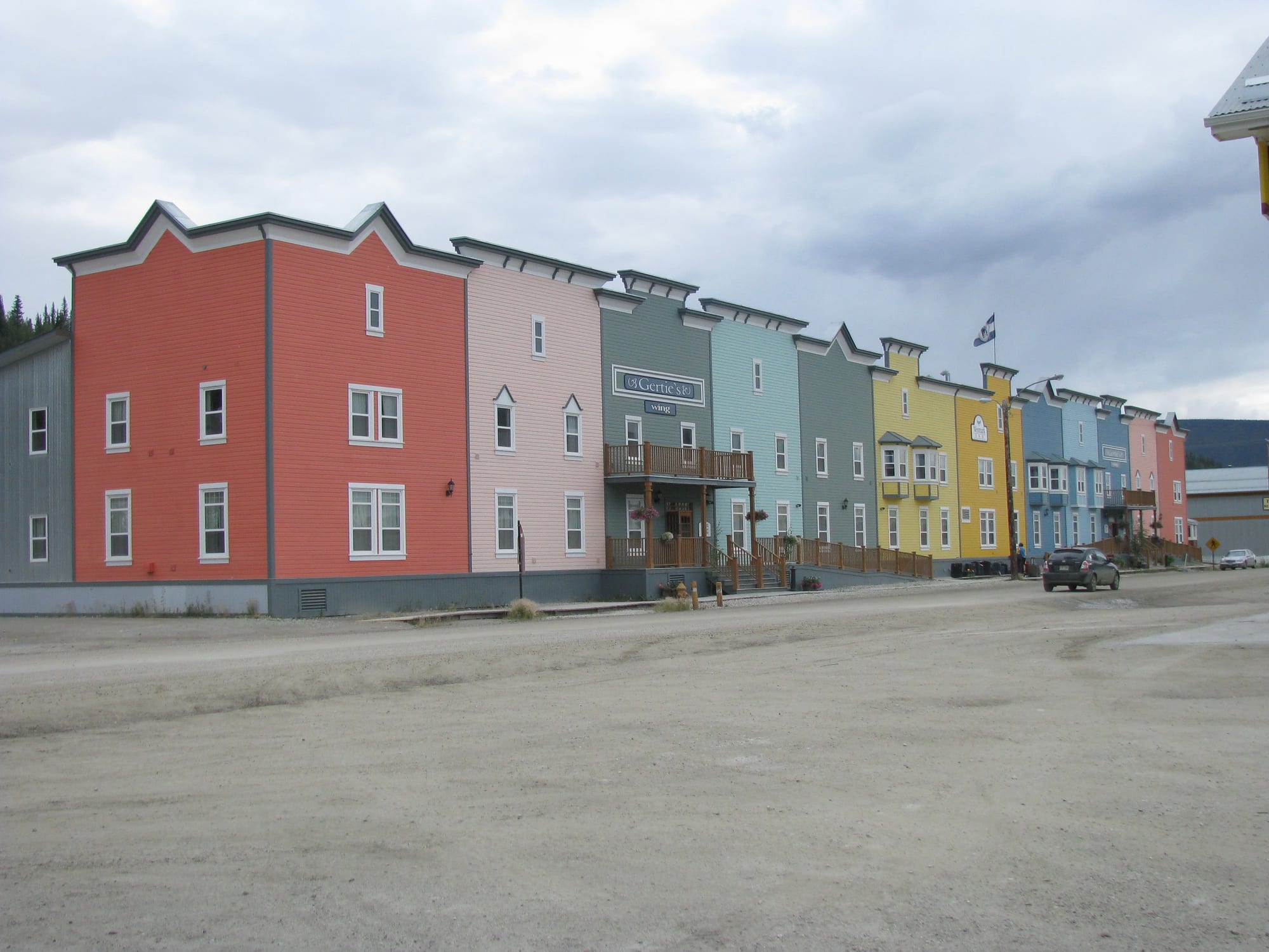
A row of two-storey false-fronted wooden buildings painted red, pink, green, blue and yellow along an unpaved street

The North, Canada

Dawson City

Colourful wooden buildings on an unpaved street in Dawson City, Yukon. (Arthur Chapman from Australia / Wikimedia Commons · CC BY 2.0)

A small Yukon town where the Klondike River meets the Yukon River, founded in 1897 and briefly one of the busiest places in the North during the Klondike Gold Rush. Today about 1,600 people live among its wooden boardwalks and false-fronted buildings, and the town lives on tourism and the gold mining that still goes on in the creeks around it.

Neighbourhoods

  • Front Street and the historic core
    • First-time visitors
    • Historic district

    The grid of unpaved streets and wooden boardwalks between the Yukon River and the hillside, protected as a national historic site. Restored gold rush buildings, the visitor centre, the sternwheeler SS Keno, St Paul's Church and Diamond Tooth Gertie's are all a few minutes apart on foot.

    Open in Maps
  • The upper streets below the Midnight Dome
    • Quiet and residential
    • Literary history

    The higher numbered avenues where the town climbs towards the hill, with houses, cemeteries, the Dawson City Museum and the cabins associated with Jack London and Robert Service. Leaning houses here show the effect of building on permafrost.

    Open in Maps
  • West Dawson
    • Camping
    • River views

    The far bank of the Yukon River, reached by the free George Black Ferry in summer and by an ice bridge in winter. A government campground stands near the landing, and the hulks of old paddle steamers rest on the shore downstream.

    Open in Maps

Things to do

The gold rush town

  • Diamond Tooth Gertie's Gambling Hallattraction

    A casino opened in 1971 by the Klondike Visitors Association, described as Canada's oldest, with vaudeville and can-can shows during the tourist season from May to September.

    Open in Maps
  • SS Kenolandmark

    A sternwheel paddle steamer built in 1922 and berthed in dry dock on the waterfront, the last of the Yukon's sternwheelers to sail the river under its own power, in 1960.

    Open in Maps
  • St Paul's Anglican Churchlandmark

    A Carpenter Gothic wooden church of 1902 on Front Street, once the cathedral of the Diocese of Yukon and now a national historic site.

    Open in Maps
  • Tr'ochëkattraction

    The site of a traditional Hän fishing camp just across the Klondike River from town, owned and managed by the Tr'ondëk Hwëch'in First Nation and part of the Tr'ondëk-Klondike World Heritage Site.

    Open in Maps
  • Midnight Domeviewpoint

    The hill above the town, reached by Dome Road or a trail, looking over Dawson and the meeting of the Klondike and Yukon rivers; it is also used for watching the northern lights.

    Open in Maps
  • Moosehideattraction

    A traditional Tr'ondëk Hwëch'in village a short way downstream, lived in from about 1906 to the early 1960s and now part of the World Heritage Site; the Moosehide Gathering, celebrating Hän traditions and culture, is held there.

    Open in Maps

The goldfields

  • Dredge No. 4landmark

    The largest wooden-hulled dredge in North America, which worked placer gold from 1913 until 1959, preserved as a national historic site on Bonanza Creek Road.

    Open in Maps
  • Discovery Claimlandmark

    The spot on Bonanza Creek where gold was found on 16 August 1896, regarded as the place where the Klondike Gold Rush began.

    Open in Maps

Short trips from the town

  • Dempster Highwaytrail

    The gravel road that leaves the Klondike Highway 40 km east of Dawson and runs north to Inuvik, crossing the Ogilvie and Richardson mountains.

    Open in Maps
  • Tombstone Territorial Parkpark

    Over 2,100 square kilometres of jagged peaks, permafrost landforms and tundra along the Dempster Highway, with hiking trails, a summer interpretive centre and campgrounds.

    Open in Maps

Seasonal events

  • Yukon QuestFebruary

    The long-distance sled dog race between Fairbanks, Alaska, and Whitehorse, for which Dawson City served as the halfway point and compulsory rest stop; since 2022 the Canadian and US sides have held their own shorter races.

  • Discovery Daysthird weekend of August

    A weekend marking the 1896 gold discovery, with a parade along Front Street, sports tournaments, a horticultural show and live music.

Eat and drink

Long-standing places and food districts in Dawson City. Hours, ratings and directions come from your maps app, always current.

Dawson City classics

  • Front Street and the downtown gridneighborhood

    Most of the town's restaurants, cafés and bars are in the few blocks of the historic core, many in restored gold rush buildings, and many keep summer hours.

    Open in Maps
  • Diamond Tooth Gertie'srestaurant

    The gambling hall serves food, local beers and drinks alongside its shows, and is used by residents as well as visitors.

    Open in Maps

Experience Dawson City

History

The Hän-speaking people of the Tr'ondëk Hwëch'in fished and hunted here long before the town existed. The heart of their homeland was Tr'ochëk, a fishing camp where the Klondike River meets the Yukon, and a base for moose hunting in the valley. In 1896 George Carmack, Skookum Jim Mason and Tagish Charlie found gold on Bonanza Creek, and in January 1897 Joseph Ladue founded the present settlement, which was named after the geologist George M. Dawson. The stampede turned a First Nations camp into a town of 16,000 to 17,000 people by 1898, and Dawson became the capital of the new Yukon Territory.

The boom was brief. By 1899 all but about 8,000 people had left, and when Dawson was incorporated as a city in 1902 it had fewer than 5,000. Fires in 1897, 1899 and 1900 and repeated floods damaged the downtown. Industrial gold dredges reworked the creeks for decades, the last shutting down in 1966. After the Second World War the Alaska Highway bypassed the town far to the south, and in 1953 the capital moved to Whitehorse; through the 1960s and 1970s the population sat between 600 and 900.

Tourism and modern placer mining have revived the town since then. In 1978 builders digging under an old hockey rink uncovered hundreds of reels of silent-era film preserved by the permafrost, now known as the Dawson Film Find. In 2004 the territorial government removed the bankrupt town council, and elections returned in 2006. In 2023 the townsite became part of the Tr'ondëk-Klondike UNESCO World Heritage Site, and on 17 May 2026 a gold rush-era hotel was destroyed by fire.

Culture & Customs

Dawson's identity rests on the gold rush and the writers who told its story. Jack London spent the winter of 1897–98 in the area and set stories such as The Call of the Wild in the Klondike; his cabin was later moved to town. Robert Service, whose Yukon poems such as "The Cremation of Sam McGee" made him the Bard of the Yukon, was posted here as a bank clerk in 1908, and the historian Pierre Berton grew up here — his childhood home is now a retreat for Canadian writers run by the Writers' Trust of Canada. The 1957 documentary City of Gold, narrated by Berton, won a prize at Cannes.

The Tr'ondëk Hwëch'in are a self-governing First Nation with their government in Dawson, and Indigenous people make up about a third of the town. In 2024 town councillors declined to swear allegiance to the King, in solidarity with a First Nations councillor-elect who refused in protest at the monarchy's historic relations with First Nations. The Yukon School of Visual Arts, a university-level art programme, gives the town a strong artistic community.

Entertainment keeps a gold rush flavour, from the vaudeville shows at Diamond Tooth Gertie's to the Sourtoe Cocktail, served with a real mummified human toe. Sport has its legend too: in 1905 the Dawson City Nuggets travelled to Ottawa by dog sled, ship and train to challenge for the Stanley Cup and lost by a combined 32 goals to 4.

Daily Life

About 1,600 people lived in Dawson at the 2021 census, a rise of nearly 15 per cent since 2016, making it the second-largest municipality in Yukon after Whitehorse. Tourism and gold mining are the main industries. Placer miners have worked the creeks continuously, and since 2016 large mining companies have invested in exploration across central Yukon, including the Coffee project south of the town.

The year has two rhythms. In summer the town fills with visitors, seasonal workers and miners, the ferry runs across the river and the shows and tours open. In winter the population settles, many businesses close, and the river is crossed by an ice bridge. Power comes mainly from the territorial hydroelectric grid, connected in 2004, with diesel generators as a backup, and fibre internet arrived in 2021.

Life is small-town: one school, the Robert Service School, runs from kindergarten to Grade 12, and the local newspaper, the Klondike Sun, comes out every two weeks. The town is built on permafrost, and leaning houses show how thawing ground can shift buildings — a growing worry for its infrastructure as the climate warms.

Food

Food in Dawson follows the North as a whole: much of what is eaten is trucked a long way, and restaurants lean on hearty dishes, local game and fish. The Klondike prospectors kept sourdough starter alive through the winter, and long-time residents are still called sourdoughs. Bannock, a simple pan-fried or baked bread, is eaten across the territory.

For the Tr'ondëk Hwëch'in, food has long come from the land and river: salmon from the Yukon River, caribou from the Fortymile and Porcupine herds, moose, small game, and plants and berries. That tradition continues in country food shared among families.

Drinking is part of the gold rush theatre. Diamond Tooth Gertie's serves local beers alongside its shows, and the town's best-known drink is the Sourtoe Cocktail, a drink served with a mummified human toe in a downtown bar. The toe was stolen in 2017 and soon returned by post with a written apology.

Planning tools

Budget

Dawson City is expensive, as is everything in the North: food, fuel and goods travel a long way, and summer rooms fill quickly in a small town with a short season. Getting there is the main cost, by a long drive or a small-plane flight. Walking the historic town costs nothing, while the goldfields need a car or a tour.

Daily Budget Midrange
USD 250–450 (hotel room, restaurant meals, a show at Gertie's, a guided goldfields trip)
Daily Budget Shoestring
USD 110–180 (campground or hostel bed, groceries, walking the town)

Book summer accommodation well ahead; many businesses open only from May to September.

Best Time to Visit

Late May to early September, when the shows, tours and most businesses are open and the nights are short or bright. The aurora season begins as nights darken from late August. Winter is very cold and quiet, with many businesses closed; for decades the Yukon Quest sled dog race made the town its halfway stop in February.

Suggested Number of Days

Two or three days cover the historic town and the goldfields. Allow four or five to add a drive or hiking in the mountains to the north. The long drive from Whitehorse adds time at each end.

First Visit
2–3 days
With Surroundings
4–5 days

Transportation

The town itself is small and walkable. A car, a taxi or a tour is needed for the goldfields on Bonanza Creek and the hill roads. The George Black Ferry crosses the Yukon River free of charge from May to October, depending on the weather; in winter an ice bridge maintained by the territorial government carries foot and vehicle traffic.

Gravel roads around Dawson are hard on tyres and windscreens; carry a spare and fuel up in town.

Airport & Station Connections

Dawson City Airport, run by the Yukon government, is about 15 km east of town in the Klondike River valley; it is an airport of entry, equipped for summer charter flights to and from Fairbanks, Alaska. By road, the Klondike Highway from Whitehorse is open all year; from Alaska, the Top of the World Highway from Tok is open only from about May to September and ends at the ferry across the Yukon River.

Walkability

The historic core is easy on foot, laid out on a grid of dirt streets with wooden boardwalks, and almost everything in town is within a short walk. Streets are dusty in summer and icy in winter. The Midnight Dome and the goldfields are beyond comfortable walking distance for most.

Safety

Canada is a safe country with low levels of violent crime. The risks in Dawson are environmental: severe winter cold, long empty roads, bears in the surrounding hills, and summer wildfire smoke.

Carry warm layers and supplies when driving the Dempster or Top of the World highways, leave word of the planned route, and keep well clear of bears and old mine workings. Check current official travel advice before travelling.

Climate

Subarctic, with wider temperature swings than Whitehorse. Summers are short and warm, often passing 30°C on some days; winters are long and very cold, regularly dropping below −40°C. The town averages fewer than 80 frost-free days a year.

Summer
short and warm — July averages about 16°C, with some days above 30°C
Winter
long and severe — January averages about −26°C, with spells below −40°C

Local Customs

Tipping of 15–20 per cent is expected in restaurants, and sales tax is added at the till. Dawson is the home of the Tr'ondëk Hwëch'in, a self-governing First Nation; Tr'ochëk and Moosehide are their sites and should be visited with respect. The gold rush is celebrated with gusto, from the can-can shows to the town's famous toe cocktail.

Diamond Tooth Gertie's admits only those aged 19 and over. Many creeks around Dawson are active mining claims: do not pan or wander on them without permission.

Common Payment Methods

The currency is the Canadian dollar. Cards and contactless payment are accepted in most businesses, though a little cash is useful in a small town with seasonal businesses.