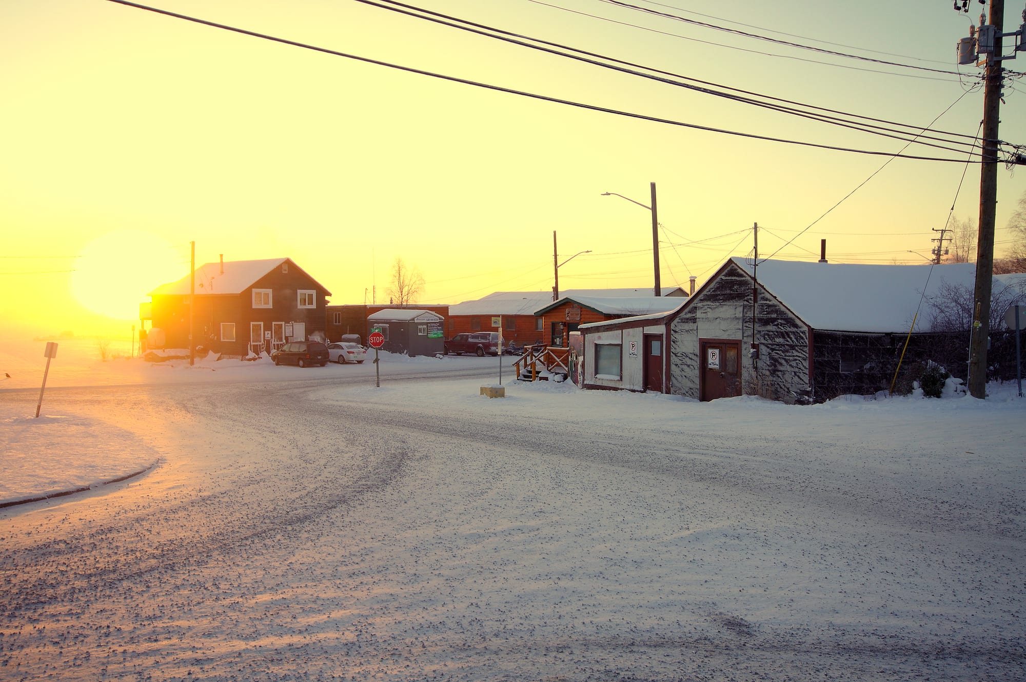
A snow-covered street in Old Town Yellowknife with wooden houses and sheds under a low golden winter sun

The North, Canada

Yellowknife

A winter afternoon in Old Town, Yellowknife, with the sun low over Great Slave Lake. (Mike Tidd from Oromocto, Canada / Wikimedia Commons · CC BY 2.0)

The capital and only city of the Northwest Territories, on the north shore of Great Slave Lake about 400 km south of the Arctic Circle. Founded as a gold-mining camp in the 1930s and made capital in 1967, it is now a government town and the service centre for the diamond mines, with a rocky Old Town on the water and long winter nights for watching the aurora.

Neighbourhoods

  • Old Town and Latham Island
    • Historic district
    • Lakeside
    • Best for food

    Where the city began in the 1930s, at the foot of the hill on a rocky peninsula and on Latham Island. Log cabins, float-plane docks, the Wildcat Cafe, Ragged Ass Road and the Pilots Monument sit among houses on bare rock, with houseboats moored in the bay.

    Open in Maps
  • Downtown
    • First-time visitors
    • Shopping
    • Close to public transport

    The New Town built up the hill from 1945, holding most of the city's commerce, offices, mid-rise flats and the Centre Square Mall with the library and visitor centre. Most of the city's hotels and restaurants are here or a short walk away.

    Open in Maps
  • Frame Lake and the Capital Area
    • Museums
    • Walks

    The small lake beside downtown, ringed by a walking trail, with City Hall, the territorial Legislative Assembly and the Prince of Wales Northern Heritage Centre on its shores.

    Open in Maps
  • Niven Lake and Range Lake
    • Quiet and residential

    Residential districts around the lakes north and west of the centre. Niven Lake is the part of the city still being built; Range Lake also has some of the city's shops.

    Open in Maps

Things to do

Old Town and the lake

  • The Wildcat Cafelandmark

    A log cabin that opened as a café in 1937 and represents the mining-camp style of early Yellowknife, saved from demolition, renovated in 2011–13 and still a summer restaurant.

    Open in Maps
  • Ragged Ass Roadattraction

    A short unpaved street in Old Town whose joke name, given in 1970, made it one of the best-known streets in Canada and the title of a Tom Cochrane album.

    Open in Maps
  • Bank of Toronto cabinlandmark

    A log cabin of 1939 that housed the Bank of Toronto from 1944, later moved to Latham Island and designated a city heritage site in 1998.

    Open in Maps
  • Pilots Monumentviewpoint

    A monument on a rocky hilltop in Old Town to the bush pilots who opened up the Northwest Territories, overlooking Old Town.

    Open in Maps
  • Houseboats of Yellowknife Bayattraction

    A community of houseboats around Jolliffe Island, where people have lived off the grid since 1978 — popular with sightseers, though their residents' relations with the city are often strained.

    Open in Maps

Museums and the capital

  • Prince of Wales Northern Heritage Centremuseum

    The territorial museum and archives near Frame Lake, with collections and exhibitions on the land, peoples, cultures and history of the Northwest Territories.

    Open in Maps
  • Legislative Assembly of the Northwest Territorieslandmark

    The territory's legislature, which has sat in its own building beside Frame Lake since 1993 and governs by consensus, without political parties.

    Open in Maps
  • Frame Laketrail

    An 84-hectare lake between downtown and the residential districts, circled by the Frame Lake Trail.

    Open in Maps

Aurora and the outdoors

  • Aurora viewingattraction

    The northern lights are the city's main draw for visitors, seen on dark nights from late August to April; tours take visitors out of town by snowmobile, dog sled or tractor ride to viewing sites and lodges.

    Open in Maps
  • Fred Henne Territorial Parkpark

    A territorial park on Long Lake at the edge of the city, one of the parks run by the Northwest Territories government and listed as a Canadian protected area.

    Open in Maps
  • Dettahattraction

    A Yellowknives Dene community across the north arm of Great Slave Lake, 6.5 km away by ice road in winter or 27 km round by the Ingraham Trail.

    Open in Maps
  • Ingraham Trailtrail

    The highway that runs about 70 km east from Yellowknife through lake country — the city's cottage country — used for camping, paddling, fishing and aurora watching.

    Open in Maps

Seasonal events

  • Snowking Winter FestivalMarch

    A month-long festival held since 1996 in a snow castle built on the frozen Yellowknife Bay, with concerts, art shows and children's theatre.

  • Old Town Ramble & RideAugust long weekend

    A three-day festival in Old Town, held every summer since 2006 on the August long weekend.

Eat and drink

Long-standing places and food districts in Yellowknife. Hours, ratings and directions come from your maps app, always current.

Yellowknife classics

  • The Wildcat Caferestaurant

    The oldest restaurant in Yellowknife, opened in 1937 in a log cabin and open in summer.

    Open in Maps
  • Old Town fish restaurantsneighborhood

    Old Town's restaurants are known for fresh fish from Great Slave Lake, served grilled or as fish and chips, alongside northern game.

    Open in Maps
  • Downtownneighborhood

    Most of the city's other restaurants, cafés and pubs are downtown.

    Open in Maps

Experience Yellowknife

History

The land around the city is the traditional home of the Yellowknives Dene, named for the copper tools they traded, who fished at Dettah on the east side of Yellowknife Bay for hundreds of years. A prospector bound for the Klondike found gold in the bay in 1898, but the find was ignored. In the 1930s, as aircraft opened up the North, prospectors came back: gold was found on the east side of the bay in 1934 and on the west side in 1935, and the Con Mine, which began producing in 1938, created the camp that became Yellowknife. By 1940 about 1,000 people lived there.

A large find at the Giant Mine in 1944 set off a post-war staking rush, and a new townsite was laid out on the hill above the Old Town waterfront in 1945–46. Yellowknife became a municipality in 1953 and, in September 1967, capital of the Northwest Territories, bringing a third boom of government building. In 1978 the Soviet nuclear-powered satellite Kosmos 954 crashed near the city, scattering radioactive debris. In 1992 a bombing at the Giant Mine during a labour dispute killed nine replacement workers.

As gold faded, diamonds took over: they were found about 300 km north in 1991, and the last gold mine in the city closed in 2004. Nunavut's creation in 1999 reduced the territory Yellowknife governed. The Deh Cho Bridge gave the city its first permanent road link to the rest of Canada in 2012. In August 2023 wildfires forced the evacuation of most of the city's 20,000 people; the order was lifted on 6 September.

Culture & Customs

The Northwest Territories recognises eleven official languages, and five are spoken in significant numbers in Yellowknife: Dene Suline, Tłı̨chǫ (Dogrib), North and South Slavey, English and French. In Tłı̨chǫ the city is called Sǫǫ̀mbak'è, "where the money is". The legislature works by consensus, without political parties, and Dene, Métis and Inuit culture is presented at the Prince of Wales Northern Heritage Centre and at community events such as Dene hand games.

The city has an outsized festival calendar for its size. Folk on the Rocks, held since 1980, has brought musicians from Buffy Sainte-Marie to Tanya Tagaq; Snowking builds a snow castle on the frozen bay each winter for a month of concerts and theatre; and the Old Town Ramble & Ride fills the old streets each August. Yellowknife hosted the first Arctic Winter Games in 1970 and has staged them four times since.

Old Town is the heart of local character: float planes, the bush pilots honoured on their monument, the houseboats on the bay, Ragged Ass Road, and the Gold Range Bar, which appears in novels by Mordecai Richler and Elizabeth Hay. In 2012 NASA named an area of Mars where the Curiosity rover landed after the city, which geologists use as a base for mapping some of the oldest known rocks in North America.

Daily Life

About 20,000 people lived in Yellowknife at the 2021 census, roughly half the territory's population. About a quarter are Indigenous, and immigrants make up about one in six residents, with the Philippines the largest source. Yellowknife is primarily a government town and the supply and service centre for the diamond mines to the north-east, among them Gahcho Kué; Diavik ended production in March 2026. It is also the main entry point for visitors to the territory.

Each late winter, trucks gather in Yellowknife to drive the Tibbitt to Contwoyto Winter Road, an ice road to the mines, featured in the television series Ice Road Truckers. A shorter ice road crosses the bay to Dettah. The legacy of gold mining is heavy: the Giant Mine left 237,000 tonnes of arsenic trioxide waste just north of the city, and a billion-dollar remediation project is under way.

Most people live in the residential districts around Frame Lake, Range Lake and Niven Lake, or in flats downtown, while some live off-grid on houseboats in the bay. The seasons set the rhythm: snowmobiles and short days in winter, fishing and boating under near-endless summer light. In February 2026 the owner of the Capitol Theatre, the city's only cinema, announced it would close.

Food

Yellowknife's food comes from the lake and the land. Fish from Great Slave Lake is the local speciality, served fresh in Old Town restaurants, grilled or as fish and chips, alongside northern game. In Dene homes, country food — moose, caribou, whitefish and berries — remains central, with dried meat a staple on the land, and bannock, a simple pan-fried or baked bread, is eaten across the North.

The Wildcat Cafe, opened in a log cabin in 1937 when the town was a mining camp, still serves food in the summer and is the city's oldest restaurant. Local beer is brewed in the city. Prices are high, because most food has to be trucked or flown in, and even a simple plate of fish and chips with a beer is expensive by southern standards. Some guided trips outside town include a shoreline breakfast or lunch, and fishing trips on the surrounding lakes are popular.

Planning tools

Budget

Yellowknife is expensive: flights are the main cost, hotels charge big-city rates, and restaurant prices are high because much of the food is trucked or flown north. Aurora tours add to the bill, and rooms are hard to find in the peak aurora months and during events.

Daily Budget Midrange
USD 250–500 (hotel, restaurant meals, an aurora tour or guided day trip)
Daily Budget Shoestring
USD 110–180 (hostel bed or campsite, groceries, buses, walking Old Town)

Book rooms and aurora packages well ahead for winter; many of the best things — Old Town, Frame Lake, the Heritage Centre — cost little or nothing.

Best Time to Visit

For the aurora, late August to April, when the nights are dark; winter adds dog-sledding and the Snowking festival but brings severe cold. June to August has long days, the sunniest summers in Canada and the lake open for paddling, but the aurora cannot be seen in the white nights around midsummer.

Suggested Number of Days

Three or four nights give a reasonable chance of clear skies for the aurora, with daytime in the city. Allow five or six to add lake and backcountry trips outside town. Cloudy weather is the main reason to stay longer.

First Visit
3–4 days
With Surroundings
5–6 days

Transportation

The centre and Old Town are compact enough to walk. YK Transit, the only public transport system in the territory, runs a few bus routes from Monday to Saturday, linking downtown, Old Town and Ndilǫ. Taxis and hire cars from the airport cover the rest, and aurora tours provide their own transport.

Do not stop on the Ingraham Trail to watch the aurora; use the designated pull-offs.

Airport & Station Connections

Yellowknife Airport, run by the territorial government within the city, has scheduled passenger flights from southern Canada and is the busiest airport in the North. By road, the all-weather Yellowknife Highway (Highway 3) links the city to the south, with a permanent crossing of the Mackenzie River since the Deh Cho Bridge opened in 2012.

Walkability

Downtown, Frame Lake and Old Town are within walking distance of each other, with Old Town at the foot of the hill and its streets laid over rock. Winter pavements are icy and the cold makes long walks hard; summer evenings are light and easy.

Safety

Canada is a safe country with low levels of violent crime. In Yellowknife the hazards are environmental: extreme winter cold, thin lake ice outside the marked ice roads, and summer wildfires — in August 2023 most of the city was evacuated as fire approached, and residents returned in September.

Dress for extreme cold on aurora nights, keep off lake ice except on official ice roads, and follow wildfire notices in summer. Check current official travel advice before travelling.

Climate

Subarctic and dry, with very cold winters and mild to warm summers. Environment Canada has ranked Yellowknife as having the coldest winter and the sunniest spring and summer of any Canadian city. Daylight ranges from about five hours in December to twenty in June.

Summer
mild to warm — July averages about 17°C, with long sunny days
Winter
very cold — January averages about −26°C, with snow lying until spring

Local Customs

Tipping of 15–20 per cent is expected in restaurants, and sales tax is added at the till. The land around the city is the home of the Yellowknives Dene, whose communities of Ndilǫ and Dettah adjoin it; they are residential communities, not attractions. People are informal and outdoors in all seasons.

Ask before photographing people, and respect private property and moorings when walking Old Town and the houseboat shoreline.

Common Payment Methods

The currency is the Canadian dollar. Cards and contactless payment work almost everywhere in the city, though a little cash is useful for small purchases.