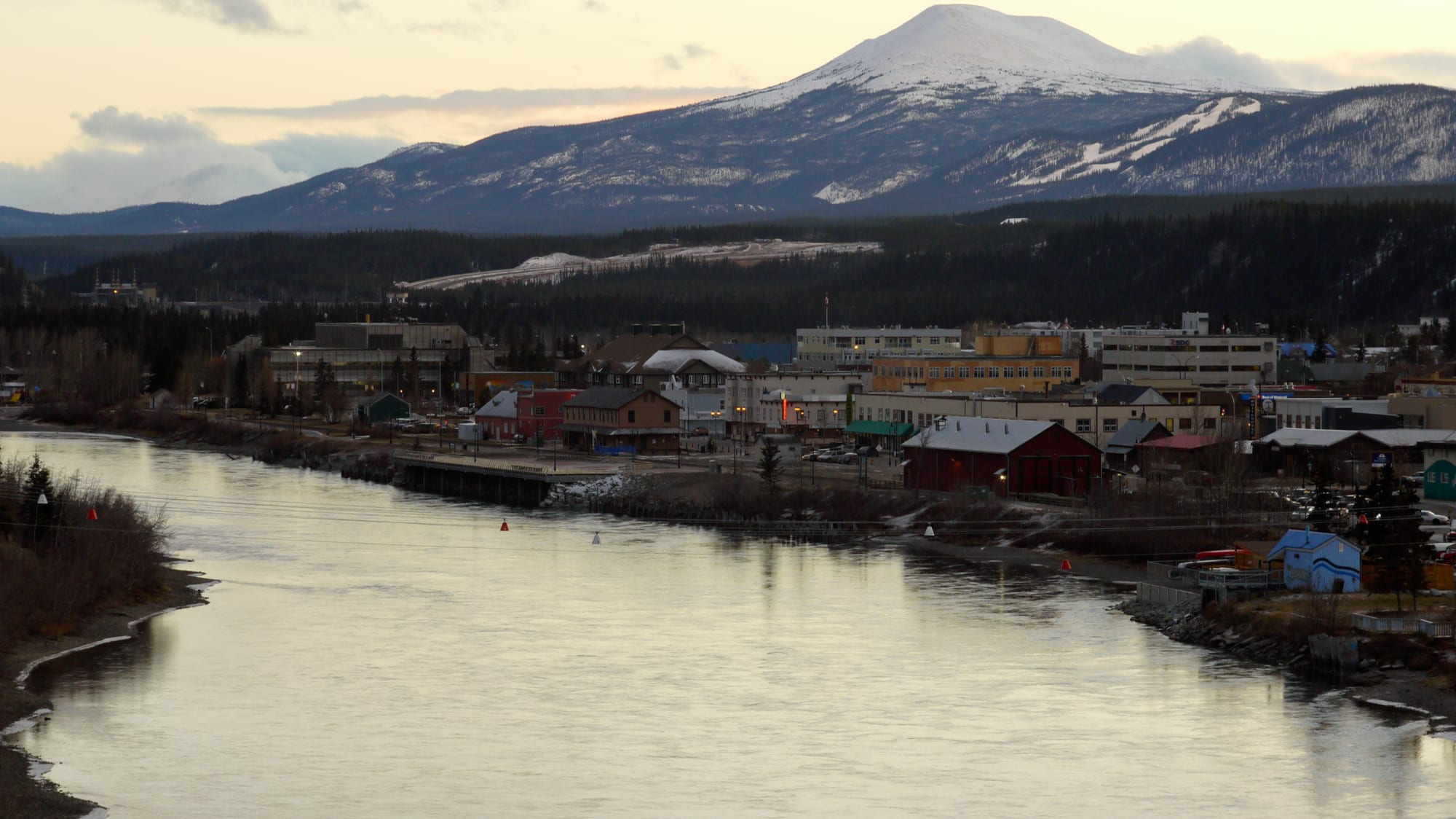
Downtown Whitehorse along the calm Yukon River at dusk, with low buildings, dark forest and a snow-capped mountain behind

The North, Canada

Whitehorse

Downtown Whitehorse on the west bank of the Yukon River. (Anthony DeLorenzo from Whitehorse, Yukon, Canada / Wikimedia Commons · CC BY 2.0)

The capital of Yukon and the largest city in Northern Canada, on both banks of the Yukon River at kilometre 1426 of the Alaska Highway. It grew where Klondike stampeders met the White Horse Rapids, at the end of the gold-rush railway from Skagway and later on the Alaska Highway, and took over as capital from Dawson City in 1953; today it is home to about seven in ten Yukoners.

Neighbourhoods

  • Downtown
    • First-time visitors
    • Best for food
    • Close to public transport

    The city's core on the west bank of the Yukon River, at the same level as the water, below the escarpment. The SS Klondike, the MacBride Museum, the Old Log Church, the Kwanlin Dün Cultural Centre, the Legislative Assembly and most restaurants, bars and shops are within walking distance.

    Open in Maps
  • Riverdale
    • Quiet and residential
    • Riverside trails

    One of the city's oldest neighbourhoods, across the bridge on the east bank of the river, a residential district from which a road climbs Grey Mountain.

    Open in Maps
  • Takhini and the upper benches
    • Quiet and residential
    • Arts and culture

    Above Two Mile Hill, the Takhini neighbourhoods include many homes that were originally army barracks and officers' houses; Yukon University and the Yukon Arts Centre are here, and Porter Creek and the new suburb of Whistle Bend lie further north.

    Open in Maps
  • Hillcrest and Valleyview
    • Close to the airport
    • Quiet and residential

    Neighbourhoods west of downtown, Hillcrest largely built from old military housing, beside the international airport.

    Open in Maps

Things to do

Gold rush and river history

  • SS Klondikemuseum

    A sternwheeler that carried freight between Whitehorse and Dawson City on the Yukon River from 1937 to 1950, now a National Historic Site on the riverbank.

    Open in Maps
  • MacBride Museum of Yukon Historymuseum

    The oldest museum in Yukon, founded in 1950 and opened in 1952, telling the territory's story from First Nations to the gold rush and after.

    Open in Maps
  • Old Log Churchmuseum

    A historic log church downtown, at Third Avenue and Elliott Street, now open as a museum.

    Open in Maps

Culture and science

  • Kwanlin Dün Cultural Centremuseum

    The Kwanlin Dün First Nation's cultural centre on the riverbank, opened in 2012, with a long house, artists' studios, a gallery and an outdoor ceremonial space.

    Open in Maps
  • Yukon Beringia Interpretive Centremuseum

    A research and exhibition centre on the Alaska Highway, opened in 1997, telling the story of Beringia, the unglaciated land bridge of the Ice Age, and of animals such as mammoths that crossed it.

    Open in Maps
  • Yukon Arts Centreattraction

    An arts centre opened in 1992 with a 428-seat theatre and a gallery whose permanent collection holds more than 100 works by artists from across northern Canada.

    Open in Maps

The river and the canyon

  • Miles Canyonviewpoint

    A narrow canyon south of the city where the Yukon River cuts through walls of basalt lava flows about 8 million years old; with the rapids below it, it was a major obstacle for gold-rush boats.

    Open in Maps
  • Schwatka Lakepark

    The reservoir formed when the river was dammed in 1958, drowning the White Horse Rapids that gave the city its name; floatplanes use it as a base.

    Open in Maps
  • Whitehorse Fishwayattraction

    A long wooden fish ladder beside the hydroelectric dam that lets Chinook salmon pass on one of the longest freshwater migrations of any salmon, with a hatchery just downstream.

    Open in Maps
  • Yukon Legislative Buildinglandmark

    The three-storey, white steel-clad home of the Yukon Legislative Assembly, beside the Yukon River and Rotary Park downtown.

    Open in Maps

Short trips from the city

  • Takhini Hot Springsattraction

    Natural hot springs about 28 km from the city centre, in use for more than a century, with pools at different temperatures and a campground.

    Open in Maps
  • Carcrossattraction

    A small community on Bennett Lake, home of the Carcross/Tagish First Nation, known for mountain biking on Montana Mountain and the nearby Carcross Desert.

    Open in Maps

Seasonal events

  • Yukon Sourdough RendezvousFebruary

    The city's annual winter festival, which celebrated its 50th anniversary in 2014.

  • Yukon QuestFebruary

    A long-distance sled dog race run since 1984 between Whitehorse and Fairbanks, Alaska, along gold-rush routes and considered one of the toughest in the world; since 2022 the Canadian and US sides have held their own shorter races.

  • Frostbite Music Festivalwinter

    A winter festival of Canadian and Yukon music, held at the Kwanlin Dün Cultural Centre.

Eat and drink

Long-standing places and food districts in Whitehorse. Hours, ratings and directions come from your maps app, always current.

Whitehorse classics

  • Yukon Brewingrestaurant

    A Whitehorse brewery, maker of Yukon Gold, the best-selling draught beer in Yukon, and Yukon Red, named Canadian Beer of the Year in 2009, with a shop and tasting room.

    Open in Maps
  • Alpine Bakerycafe

    A downtown bakery and café known for organic breads, baked goods and hand-made chocolates.

    Open in Maps

Food districts and bars

  • Main Street and downtownneighborhood

    Most of the city's restaurants, cafés and pubs are downtown, several of them serving local game and Arctic char alongside everyday Canadian food.

    Open in Maps
  • Winterlong Brewingrestaurant

    A smaller craft brewery with a tasting room on Mount Sima Road.

    Open in Maps

Experience Whitehorse

History

Archaeological work at Canyon City, south of downtown, has shown that First Nations used the area for several thousand years, with seasonal fish camps along the river and a portage trail around Miles Canyon. The discovery of gold in the Klondike in August 1896 by Skookum Jim, Tagish Charlie and George Washington Carmack changed everything. By June 1898 prospectors heading downriver to Dawson had piled up at Canyon City, and many boats and five lives had been lost to the White Horse Rapids, named for their resemblance to a white horse's mane. Tram lines were built to carry goods around the rapids.

The White Pass and Yukon Route railway from Skagway, begun in May 1898 and completed in 1900, ended at the foot of the rapids, where goods were transferred to riverboats, and the town grew up around the terminus. Copper claims were staked nearby in 1898 and 1899, and a fire in 1905 swept the town without loss of life. Sternwheelers such as the SS Klondike carried freight down the Yukon River to Dawson for decades.

In 1942 the United States Army built the Alaska Highway, 2,600 km long, in a single season, passing through Whitehorse. The city was incorporated in 1950 and its population had doubled by 1951 compared with 1941. On 1 April 1953 it replaced Dawson City as the capital of the Yukon Territory. A hydroelectric dam in 1958 created Schwatka Lake and drowned the rapids that gave the city its name.

Culture & Customs

The gold rush is the city's founding story, and it is retold in the SS Klondike, the MacBride Museum and the verse of Robert Service, the Bard of the Yukon, whose poems such as The Cremation of Sam McGee drew on the Klondike. Winter is celebrated rather than endured: the Yukon Sourdough Rendezvous festival fills February, and the Yukon Quest, the 1,000-mile sled dog race between here and Fairbanks, Alaska, has since 2022 been run as separate, shorter Canadian and US races.

First Nations culture is part of the city's public life. The Kwanlin Dün Cultural Centre, opened in 2012 on the riverbank, has a long house, studios, a gallery and an outdoor ceremonial space, and hosts gatherings and festivals; First Nations people make up about 12 per cent of the population and Métis and Inuit a further share. The Yukon Arts Centre, opened in 1992, has a 428-seat theatre and a gallery of northern art, and the Frostbite Music Festival brings Canadian and Yukon musicians to the city each winter.

Sport and the outdoors shape daily culture. The Canada Games Centre multiplex is the hub of indoor recreation, the city has hosted the Arctic Winter Games several times, and residents ski, cycle and paddle on the trails and rivers around the city. The Whitehorse Daily Star, founded in 1900, is one of the city's two newspapers.

Daily Life

About 28,200 people lived within city limits at the 2021 census, a rise of more than 12 per cent since 2016, and about 31,900 in the wider census agglomeration — roughly 70 and 79 per cent of all Yukoners. About 15 per cent of residents are immigrants, the largest group from the Philippines, and Filipino Canadians are the city's biggest visible minority.

As the territorial capital, Whitehorse is a government town: the Legislative Assembly sits downtown, and 13 of its 21 members represent Whitehorse ridings. The territorial government also owns and runs the airport. Across the North, government is the largest employer and mining drives the private economy; the city is also home to Yukon University and Whitehorse General Hospital.

Most people live outside the old downtown, in neighbourhoods such as Riverdale across the river, the former military housing of Takhini and Hillcrest, Porter Creek and Whistle Bend, a new suburb under construction since 2010 where much of the city's growth is taking place. Life follows the extremes of the subarctic year: summer days of more than 19 hours given to the outdoors, and long, cold winters of short days when the aurora lights the sky.

Food

Whitehorse eats like a small Canadian city with a northern accent. Restaurants downtown serve local game and Arctic char alongside a mix of international cooking, Japanese among it.

Northern traditions run underneath. Klondike prospectors kept sourdough starter alive through the winter, and long-time residents are still called "sourdoughs". Bannock, a simple pan-fried or baked bread probably introduced by fur traders, is eaten across the North, and First Nations cooking draws on moose, caribou, whitefish and berries; dried meat is a staple on the land.

Yukon Brewing is based in Whitehorse: its Yukon Gold is the best-selling draught beer in Yukon, its Yukon Red was named Canadian Beer of the Year in 2009, and since regulations changed in 2009 it has also distilled a single malt whisky sold as Two Brewers. Winterlong Brewing and other small brewers add to the scene, and bakeries such as the Alpine Bakery are known for their bread.

Planning tools

Budget

The North is the most expensive part of Canada, though Yukon, reachable by road, is the cheapest territory. In Whitehorse, flights and hotels are the main costs, and hotels fill quickly in summer. Aurora tours, guided trips and a hire car for the highways add up; museums, riverside walks and the canyon are cheap or free.

Daily Budget Midrange
USD 250–500 (hotel, restaurant meals, an aurora tour or guided day trip)
Daily Budget Shoestring
USD 110–180 (hostel or campground, groceries, city buses, a shared hire car)

Book summer accommodation and winter aurora packages well ahead, and allow a spare day for weather delays on northern flights.

Best Time to Visit

June to August for hiking, paddling on the Yukon River and very long days, with more than 19 hours of daylight at midsummer. For the northern lights, come from late August to April, when the nights are dark; late winter adds dog sledding, the Yukon Quest and Sourdough Rendezvous in February. September brings autumn colour.

Suggested Number of Days

Two or three days cover the city itself. Five to seven allow for the lakes, hot springs and smaller communities within driving range, or the long road north towards Dawson City. In winter, extra nights improve the chance of clear skies for the aurora.

First Visit
2–3 days
With Surroundings
5–7 days

Transportation

Downtown is compact, but the city is spread over a large area along the Alaska Highway. Whitehorse Transit runs buses on eight routes, and taxis are metered. A hire car is the practical way to reach Miles Canyon, the hot springs and anything further out; a seasonal bus runs to Dawson City in summer.

Carry winter survival gear when driving outside the city in winter, and allow for long gaps between services on the highways.

Airport & Station Connections

Erik Nielsen Whitehorse International Airport sits just west of downtown, a short taxi ride away, with flights to Vancouver and other southern cities. By road, the Alaska Highway links Whitehorse with British Columbia and Alaska, and the Klondike Highway runs north to Dawson City.

Walkability

Downtown is flat, compact and easy to walk, with paths along the Yukon River. Much of the rest of the city sits above the escarpment and is spread out, so walking between neighbourhoods takes time. In winter, cold and short days make walking slower, and the riverside and canyon trails can be icy.

Safety

Canada is a safe country with low levels of violent crime. The real dangers are the environment: extreme cold, isolation, long stretches with no services or mobile signal, grizzly and black bears, polar bears along the Arctic coast and in Nunavut, and summer wildfires — Yellowknife was evacuated in 2023. In Whitehorse itself, cold snaps can push temperatures below −40°C, and bears can be met on trails at the edge of the city.

Dress for extreme cold in winter, carry bear spray and make noise on trails in summer, and follow wildfire notices. Check current official travel advice before travelling.

Climate

A subarctic climate, milder than comparable northern towns such as Yellowknife because of the city's location in the Whitehorse valley, and in the rain shadow of the Coast Mountains — Whitehorse is Canada's driest city. Winter days are short; summer days are very long.

Summer
warm and dry — July has an average daily high of about 20.6°C
Winter
long and cold — January has an average daily low of about −19.2°C, and cold snaps can bring temperatures below −40°C

Local Customs

Whitehorse is a small, informal city with a strong outdoor culture and a frontier pride rooted in the gold rush; long-time residents call themselves sourdoughs. It lies on the traditional territory of the Kwanlin Dün First Nation, and First Nations people make up a significant share of the population; ask before photographing people or ceremonies.

Tip 15–20 per cent in restaurants and taxis; sales tax is added at the till.

Common Payment Methods

The currency is the Canadian dollar. Cards and contactless payment are accepted almost everywhere, and ATMs are easy to find downtown. Carry some cash for trips to small communities on the highways. Cash totals are rounded to the nearest five cents.