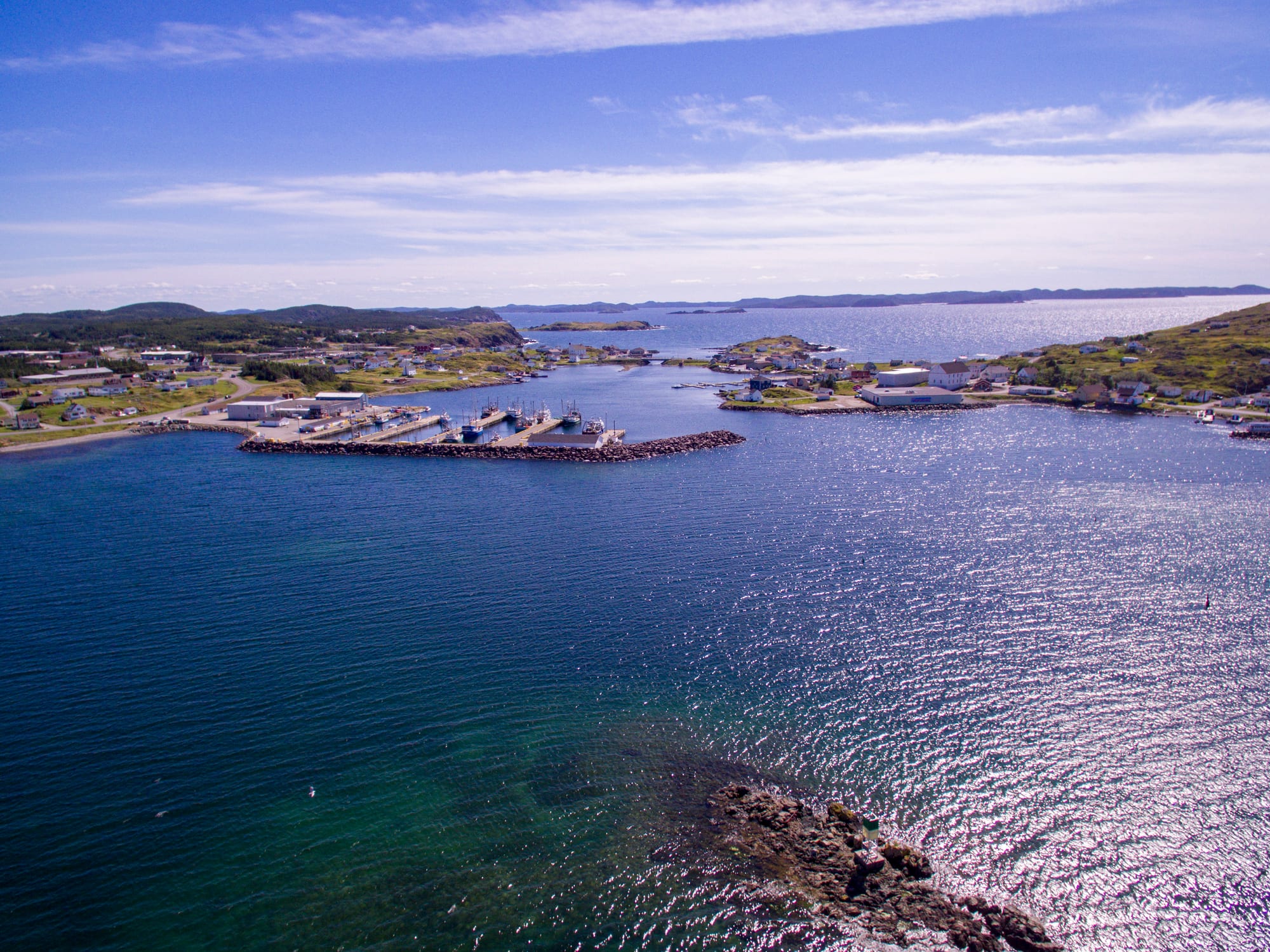
Aerial view of Twillingate's main harbour, with a stone breakwater, fishing boats and houses on green shores around deep blue water

Newfoundland & Labrador, Canada

Twillingate

The main harbour of Twillingate on the Twillingate Islands, Newfoundland. (Shhewitt / Wikimedia Commons · CC BY-SA 4.0)

A town on the Twillingate Islands in Notre Dame Bay, off Newfoundland's north-east coast, joined to the main island by a causeway. One of the oldest ports on the island, it was for two centuries a busy fishing and trading centre; since the cod moratorium of 1992 it has turned to tourism, known for icebergs in late spring, whales and its folk festival.

Neighbourhoods

  • Twillingate harbour and the town centre
    • First-time visitors
    • Harbour views
    • Boat tours

    The main harbour between the north and south islands, joined by the Tickle Bridge, with Route 340 running through as Toulinquet Street and Main Street. Boat tours, shops, restaurants and the town's museum are here, and the Top of Twillingate trail climbs to the highest point.

    Open in Maps
  • Crow Head and the north island
    • Icebergs and whales
    • Coastal walks

    Main Street North leads past Back Harbour and Wild Cove to the small community of Crow Head and the Long Point Lighthouse, the classic place to look out for icebergs and whales.

    Open in Maps
  • Durrell
    • Quiet and residential
    • Museums

    A former separate community on the south island, now part of the town, reached along Main Street South, with its own museum, a winery and B&Bs and cottages along the shore.

    Open in Maps

Things to do

The coast, icebergs and whales

  • Long Point Lighthouselandmark

    An active lighthouse completed in 1876 outside Crow Head on North Twillingate Island, visited by thousands each year for its views over the ocean to passing icebergs and whales.

    Open in Maps
  • Iceberg and whale-watching boat toursattraction

    Several local boat companies run tours from the harbour to look for icebergs, most common in late May and early June, and for the humpback whales seen offshore.

    Open in Maps
  • Top of Twillingate Walking Trailtrail

    A walking trail off Bayview Street up to the highest point in town, one of several hiking trails on the islands.

    Open in Maps

Museums and local culture

  • Twillingate Museummuseum

    The town's museum and craft shop, whose collection includes Maritime Archaic artefacts found at Back Harbour in 1967.

    Open in Maps
  • Durrell Museummuseum

    A small local museum in Durrell, on the south island.

    Open in Maps
  • Prime Berthmuseum

    A fishing museum near the causeway, about 5 km outside town, with exhibits including a walk-in cod trap.

    Open in Maps

Short trips

  • Boyd's Cove Beothuk sitemuseum

    An interpretation centre and a walking trail to the house pits of a Beothuk village about 300 years old, in the community of Boyd's Cove on the road to Twillingate.

    Open in Maps

Seasonal events

  • Fish, Fun and Folk Festivalend of July

    The town's annual festival of local music, dances and Newfoundland entertainment, with a parade, a screech-in and fireworks towards the end, drawing visitors from around the world.

Eat and drink

Long-standing places and food districts in Twillingate. Hours, ratings and directions come from your maps app, always current.

Twillingate classics

  • Fish and chips on Main Streetneighborhood

    Small restaurants and takeaways in town serve fish and chips, chowder and, in season, lobster, some with decks looking over the water.

    Open in Maps
  • Auk Island Wineryrestaurant

    A winery in Durrell making wines from local berries and iceberg water, with tastings and its own wine ice cream.

    Open in Maps

Experience Twillingate

History

People have lived on these islands for a very long time. The Maritime Archaic occupied the area around 3,500 years ago, and were later followed by the Beothuk, and possibly the Dorset, who lived here until Europeans arrived. The French may have fished these waters as early as 1500. The first European settlers came in the 17th century, mostly fishermen and their families from the West Country of England. The Beothuk survived in small numbers near Twillingate and the mouth of the Exploits River until the early 19th century.

The sheltered harbour and the rich fishing grounds nearby made Twillingate an important fishing community, and for more than two centuries it was a busy trade and service centre for the Labrador and northern shore fisheries. It had its own newspaper, the Twillingate Sun, from the 1880s until the 1950s, covering local, provincial and international news. The town was incorporated in 1965, taking in smaller localities such as Back Harbour, Bayview, Durrell and Wild Cove, and the Walter B. Elliott causeway now links the islands to the main island of Newfoundland.

The moratorium on fishing northern cod, announced on 2 July 1992, and the collapse of the fishery that followed forced the town to look to tourism for income, becoming a popular spot for visitors in the summer, drawn by icebergs, whales and the festival.

Culture & Customs

Twillingate residents value the area's culture and traditions, and folk music and festivities are central to them. Traditional Newfoundland songs such as "I's the B'y", whose chorus runs "Fogo, Twillingate, Moreton's Harbour, all around the circle", and "Lukey's Boat" are still sung at local events. In summer, dinner theatre, kitchen parties and local musicians entertain visitors. Mummering at Christmas, once common here, is now practised by fewer people.

The Fish, Fun and Folk Festival at the end of July is the town's big event, with local talent, dances and Newfoundland entertainment, a parade, fireworks and a screech-in, the mock ceremony in which visitors kiss a fish, drink a shot of screech and become "Honorary Newfoundlanders".

The town has two museums — the Twillingate Museum, with Maritime Archaic artefacts found at Back Harbour, and the Durrell Museum — and several art galleries. Hockey matters too: in 2020 Twillingate was named the Kraft Hockeyville Canada champion, winning a quarter of a million dollars in upgrades for the George Hawkins Arena. The seal hunt is still practised here, and the town was the setting for Anne Troake's 2005 documentary about her family's long involvement in it.

Daily Life

About 2,100 people lived in Twillingate at the 2021 census, a fall of about 3 per cent from 2016, continuing a long decline. The population is ageing: the median age rose steadily through the 1990s and 2000s and is well above the provincial average.

Since the cod moratorium, fishing is practised much less, though some fishermen still catch crab, lobster and other species. Most jobs now are in construction, logging and services to the community, and summer tourism is a big part of the economy — boat tours, B&Bs, cottages, restaurants and craft shops all depend on the season. The town calls itself the "Iceberg Capital of the World".

The town stretches along a series of coves on two islands, from Bayview and Durrell to Back Harbour and Wild Cove, most of it close to sea level, with parts of Durrell, Bayview and the centre on higher ground. Route 340 runs through as Toulinquet Street and Main Street, and the Tickle Bridge joins the north and south islands. Gander, about an hour and a half away, is the nearest larger town for flights and many services.

Food

Food here is the cooking of a Newfoundland fishing port. Fish and chips, made with cod, is the everyday meal in the town's restaurants and takeaways, along with chowder and, in season, fresh lobster; crab is also landed by local fishermen.

Older island dishes remain home cooking. Fish and brewis combines salt cod with hard bread softened in water, often with scrunchions, small pieces of fried pork fat. Toutons, fried bread dough, are eaten with molasses, and Jiggs dinner — salt beef boiled with cabbage, potatoes, carrot and turnip — is a traditional Sunday meal. Seal flipper pie is a dish of the spring seal hunt, still practised in Twillingate.

Wild berries grow across the islands, and the local winery in Durrell turns them, along with water from icebergs, into fruit wines and even wine ice cream. Bakeapples, the local name for cloudberries, and partridgeberries go into jams, pies and sauces. Screech, a Jamaican rum bottled in the province, is the drink of the screech-in.

Planning tools

Budget

Prices are close to the Canadian average. Accommodation is mostly B&Bs, holiday homes and cabins, which fill up in peak season, above all during the festival in late July. A hire car is needed to get here, and boat tours are the main extra cost; the lighthouse, trails and harbour views are free.

Daily Budget Midrange
USD 160–300 (B&B or cottage, restaurant meals, hire car, a boat tour)
Daily Budget Shoestring
USD 80–120 (simple B&B room or cabin shared, groceries and fish and chips)

Book early for the festival at the end of July and for the iceberg season in late May and June.

Best Time to Visit

Late spring and summer. Icebergs drifting down Iceberg Alley are most common in late May and early June, and humpback whales are seen offshore in the warmer months. Tourism is a summer business, and the Fish, Fun and Folk Festival fills the town at the end of July. Winter is cold, wet and very snowy.

Suggested Number of Days

One or two days are enough for the town, its trails and a boat tour. Three or four allow for the surrounding islands and communities on the road in. Fog and wind can cancel boat trips, so a spare day helps in iceberg season.

First Visit
1–2 days
With Surroundings
3–4 days

Transportation

A car is essential. Route 340, the Road to the Isles, crosses New World Island and the Walter B. Elliott causeway to Twillingate and runs through the town and on round the north island. The town itself stretches along several coves and both islands, linked by the Tickle Bridge.

Drive slowly at dusk and at night: moose collisions are frequent on Newfoundland's highways.

Airport & Station Connections

The nearest airport is Gander International Airport, in Gander, about 100 km to the south — roughly an hour and a half by car. From western Newfoundland the drive comes through Lewisporte, about an hour away, and from the east by Route 330 from Gander through Gander Bay. Most visitors arrive by hire car.

Walkability

The harbour area is walkable, and there are well-kept hiking trails, but the town is spread across coves, hills and two islands, so a car is needed to get between Durrell, the centre and the lighthouse. Elevation varies a good deal across the town.

Safety

Canada is a safe country with low levels of violent crime. The hazards are natural: fog, sudden storms, cold water, and rough seas and slippery rocks at coastal viewpoints, as well as moose on the roads.

Stay back from cliff edges and wave-washed rocks, carry warm and waterproof layers even in summer, and slow down at dusk for moose. Check current official travel advice before travelling.

Climate

A cool to cold, wet and very snowy climate with big differences between the seasons. Summers are short and changeable, and icebergs pass offshore in late spring.

Summer
cool to mild; around 15–22°C across the island of Newfoundland, cooler on the coast and in fog
Winter
cold, wet and very snowy; for comparison, around −8 to 0°C in St. John's

Local Customs

Twillingate values its traditions. Folk music, kitchen parties and the old songs — "I's the B'y" names Twillingate in its chorus — are part of everyday culture, and visitors can be made "Honorary Newfoundlanders" at a screech-in, which involves kissing a fish and drinking a shot of screech. Most residents are Protestant.

Tip 15–20 per cent in restaurants; sales tax is added at the till.

Common Payment Methods

The currency is the Canadian dollar. Cards and contactless payment are widely accepted, and a little cash is useful for small purchases. Cash totals are rounded to the nearest five cents.