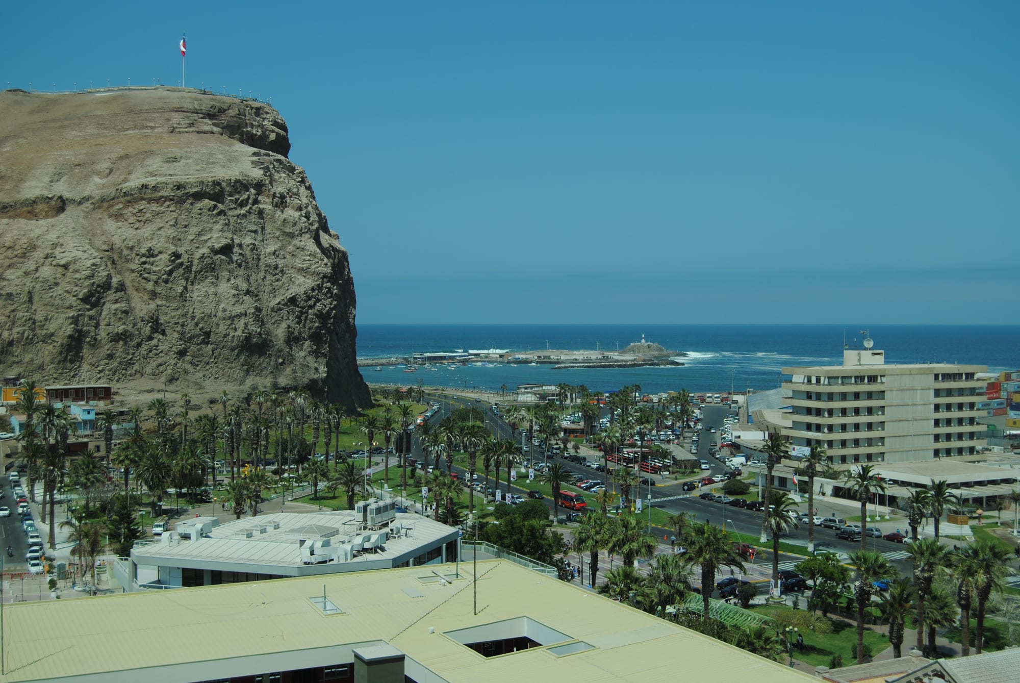
The sheer brown rock face of the Morro de Arica above palm-lined avenues, with the blue Pacific and a small island behind

Arica, Iquique & the Far North, Chile

Arica

The Morro de Arica headland rising above the city centre and the harbour. (Juangoo0 / Wikimedia Commons · CC0)

Chile's northernmost city, a desert port about 18 kilometres from the Peruvian border where the Azapa and Lluta valleys reach the sea. It grew on Potosí silver under Spain, was taken from Peru by Chile in 1880 and is now a mild, almost rainless seaside city with surf breaks, the Morro headland and the world's oldest artificial mummies.

Neighbourhoods

  • City centre and the Morro
    • First-time visitors
    • Historic district
    • Close to public transport

    The narrow grid of streets below the Morro, with the pedestrian Paseo 21 de Mayo and Paseo Bolognesi, Plaza Colón and the iron Cathedral of San Marcos, the old customs house and the Arica–La Paz railway station. Most shops, banks and cheap places to eat are here.

    Open in Maps
  • Playa Chinchorro and the northern beaches
    • Beaches
    • Families
    • Surfing for beginners

    The long, flat sandy shore north of the port, from Chinchorro to Las Machas, with a seafront promenade, food stalls, restaurants and play areas. The beaches north of town suit swimmers and beginner surfers, and the bus terminals are a short way inland.

    Open in Maps
  • The southern beaches
    • Beaches
    • Surfing

    South of the Morro the coast turns rocky, with smaller beaches such as El Laucho and La Lisera, then Playa Brava, Arenillas Negras and Corazones. Experienced surfers and bodyboarders head for the breaks on this side.

    Open in Maps
  • Azapa Valley
    • Museums
    • Countryside
    • Olive groves

    A narrow green oasis running inland from the city between bare desert hills, planted with olives, vegetables and fruit trees. The village of San Miguel de Azapa holds the archaeological museum with its Chinchorro mummies, and geoglyphs mark the hillsides.

    Open in Maps

Things to do

Famous landmarks

  • Morro de Aricaviewpoint

    The 139-metre headland above the city, stormed by Chilean troops on 7 June 1880, now crowned by a giant Chilean flag, a war museum and a statue of Jesus, reached by a short paved footpath from the south end of Calle Colón.

    Open in Maps
  • Cathedral of San Marcoslandmark

    A cast-iron church on Plaza Colón, inaugurated in 1876 after the 1868 earthquake destroyed its predecessor; its design is often attributed to Gustave Eiffel, though no evidence in local or French archives supports the attribution.

    Open in Maps
  • Arica–La Paz railwaytransit hub

    The terminus of the line opened in 1913 under the 1904 treaty between Chile and Bolivia, the shortest line from the Pacific coast to Bolivia; passenger services ended in 1996.

    Open in Maps

Museums and archaeology

  • Museo de Sitio Colón 10museum

    A site museum beside the Morro, on a Chinchorro cemetery with 48 mummies found in 2004 during building work for a hotel; it is part of the UNESCO World Heritage Site for Chinchorro settlement and mummification inscribed in 2021.

    Open in Maps
  • Archaeological Museum of San Miguel de Azapamuseum

    The University of Tarapacá's museum in the Azapa Valley, covering 10,000 years of the region's past and displaying Chinchorro mummies, with petroglyphs in its grounds.

    Open in Maps

Beaches and the coast

  • Playa Chinchorrobeach

    The city's main beach, with a promenade, food stalls and the boilers of the American warship Wateree, carried inland by the 1868 tsunami, nearby.

    Open in Maps
  • El Lauchobeach

    A city beach south of the centre, the next along the coast after Playa del Alacrán.

    Open in Maps
  • La Liserabeach

    The beach between El Laucho and Playa Brava, on the stretch of coast south of the centre.

    Open in Maps
  • Playa Corazones and the Anzota cavestrail

    The rocky coast at the southern end of the city's beaches, where a path leads past cliffs to the sea caves of Anzota, known for climbing, walking and seabirds.

    Open in Maps
  • Lluta River wetlandpark

    The mouth of the Lluta River just north of the city, where resident and migrating birds gather at different times of year.

    Open in Maps

Short trips from the city

  • Tacnaattraction

    The Peruvian city across the border, reached by shared taxis, buses and a train; many Arica residents cross for cheaper dentists, doctors and shopping.

    Open in Maps
  • Pucará de Copaquillalandmark

    A 12th-century hill fort at about 3,000 metres on the road up to the altiplano, with a double stone wall and views over the gorges, declared a National Monument.

    Open in Maps
  • Lauca National Parkpark

    The high Andean park near Putre that holds Lake Chungará, at about 4,500 metres, with volcanoes, vicuñas and flamingos; a night in Putre on the way up eases the effects of altitude.

    Open in Maps

Seasonal events

  • Carnaval con la Fuerza del SolJanuary or February

    Arica's Andean carnival, three days of dance troupes, music and cultural events in the streets.

  • Anniversary of the Battle of Arica7 June

    A regional holiday marking the 1880 storming of the Morro, with commemorations in the city.

  • Semana AriqueñaJune

    Arica's city week, which includes the national cueca championship.

  • Fiesta de San Pedro29 June

    The fishermen's feast of their patron saint, with processions of boats in the bay.

Eat and drink

Long-standing places and food districts in Arica. Hours, ratings and directions come from your maps app, always current.

Arica classics

  • Azapa olivesmarket

    The valley's fleshy purple olives, bitter and sharp, sold cured and as oil, and eaten with marraqueta bread and butter in the traditional desayuno ariqueño.

    Open in Maps
  • Chifa restaurantsneighborhood

    Chinese-Peruvian chifa cooking, brought by the Chinese community that has lived in Arica since the 1890s, is a staple of the city centre.

    Open in Maps

Food districts and markets

  • Playa Chinchorro seafrontneighborhood

    Small food areas, seafood restaurants and snack stalls along the beach promenade north of the centre.

    Open in Maps
  • City-centre empanada shopsneighborhood

    Bakeries and snack bars around the pedestrian streets selling empanadas, cheese ones among them.

    Open in Maps

Experience Arica

History

People have lived where the Azapa and Lluta valleys meet the sea for about 10,000 years. The Chinchorro, sedentary fishing people of this coast, were deliberately mummifying their dead by about 5050 BC — men, women and children alike, their bodies reinforced, modelled with clay and given wigs and pigments — some two thousand years before the Egyptians. Their burials still turn up beneath the city, and in 2021 their settlements and cemeteries in the region were listed as a UNESCO World Heritage Site.

Spaniards settled here under Captain Lucas Martínez de Begazo in 1541, and by 1545 Arica was the main port for the silver of Potosí, one of the leading harbours of the Spanish Empire. Its wealth drew Francis Drake, Thomas Cavendish and other pirates and privateers. Earthquakes and tsunamis struck repeatedly: one in 1604 forced the town to be rebuilt, and the great earthquake of 13 August 1868 destroyed the church and threw the American warship Wateree far inland. After independence Arica belonged to Peru, which opened a railway to Tacna in 1855.

On 7 June 1880, during the War of the Pacific, Chilean troops stormed the Morro, the last Peruvian defence. The 1929 Treaty of Lima returned Tacna to Peru and left Arica in Chile. From 1953 a free zone, and from 1958 a development board offering tax incentives, brought car assembly plants; General Motors built pickups there until 2008. In the 1980s smelter waste from Sweden was left at a site later surrounded by social housing, causing lasting arsenic poisoning among residents. Arica hosted matches of the 1962 World Cup and became capital of the new Arica and Parinacota Region in 2007.

Culture & Customs

Arica's identity is that of a border city with roots on both sides. Aymara communities have lived in the region for millennia, and many families keep links with villages in the valleys and the altiplano. The city is also home to much of Chile's Afro-Chilean community, descendants of people enslaved in the colonial era, and to a Chinese Chilean community that arrived as miners and railway workers in the 1890s. Many residents share cultural ties with neighbouring Peru and Bolivia, and people cross daily to Tacna.

Andean music and dance are at the heart of the calendar. The Carnaval con la Fuerza del Sol fills the streets for three days in January or February with dance troupes, and June brings the Semana Ariqueña, which includes the national cueca championship, the regional holiday for the Battle of Arica on 7 June, and the fishermen's processions in the bay for San Pedro on 29 June.

The sea shapes local life. Arica's breaks are known well beyond Chile: the wave called El Gringo hosts surfing and bodyboarding championships, the city held an international surfing contest in 2007, and a leg of the world bodyboarding tour has been held here since 2004. The city also gave its name to the Arica School, after the spiritual teacher Oscar Ichazo held a ten-month training here in 1970.

Daily Life

The 2024 census counted about 242,000 people in the commune of Arica, almost the whole population of the region; about 15 per cent were immigrants, nearly all from elsewhere in South America. The city spreads outward from the Morro into the desert towards the Peruvian border, and the Azapa Valley's year-round farms produce olives, tomatoes, vegetables and citrus.

The port is the economic backbone. Arica serves as a free port for Bolivia and handles a large part of that country's foreign trade, it is the end of an oil pipeline from Oruro, and railways link it to Tacna and La Paz. An industrial park run by the Iquique free zone company stands near the airport. Tourism, from Bolivian families on the beaches to visitors heading for the altiplano, adds to the economy, and cross-border commerce with Tacna is part of everyday life, as residents cross for cheaper doctors, dentists and shopping.

The pace is relaxed and outdoor, with evenings on the beaches and the pedestrian streets. Long-running concerns include the health legacy of the toxic waste site, the scarcity of water in one of the driest inhabited places on Earth, and the city's exposure to earthquakes and tsunamis.

Food

Arica's kitchen draws on four zones — coast, valley, foothills and altiplano. The best-known product is the aceituna de Azapa, the Azapa olive: purple, fleshy and strong-tasting, cured bitter or mild, pressed for oil and mixed into white cheeses with paprika and oregano. The Azapa Valley also grows sweet tomatoes, and the valleys produce passion fruit, guava, mango and tumbo.

The traditional desayuno ariqueño, the Arica breakfast, is marraqueta bread with butter and Azapa olives, served with lemon verbena tea. Seafood is eaten all along the coast, and a local speciality, the copa Martínez, blends raw eggs with ceviche, piure — a strong-flavoured sea squirt — and mixed shellfish; it is named after the owner of the seafood bar who created it.

From the highlands come quinoa, the sweet maize of Socoroma, and chuño, potatoes freeze-dried in the frosts of June and July by a traditional method. The city's Chinese community has made chifa, Chinese-Peruvian cooking, a staple of the centre, and empanada shops serve turnovers with many fillings, cheese among them.

Planning tools

Budget

Arica is one of the cheaper Chilean cities for daily costs, with set lunches, empanada shops, chifa restaurants and hostels close to the beaches. Costs rise for trips to the altiplano, where most visitors pay for a tour or hire a car, and in January and February, when Chilean and Bolivian holidaymakers fill the city.

Daily Budget Midrange
USD 95–180 (seafront hotel, restaurant dinners, a guided altiplano tour or hire car)
Daily Budget Shoestring
USD 40–70 (hostel bed, set lunches and empanadas, city buses and colectivos)

The Morro footpath, the cathedral and the city beaches cost nothing; buy bottled water, as the tap water is not recommended for drinking.

Best Time to Visit

Arica is mild all year, which has earned it the name 'city of eternal spring'. Summer, December to February, is the beach season and the busiest; in winter the beaches are quiet and the sky is often grey with the coastal fog called camanchaca. For trips up to the altiplano the drier months from about April to November are better.

Suggested Number of Days

Two or three days cover the city, its museums and its beaches. Adding the valleys and the altiplano takes several more, and the climb to the high parks is best done slowly with a night at mid-altitude, which adds time.

First Visit
2–3 days
With Surroundings
4–6 days

Transportation

The centre is compact, and city buses and colectivos, shared taxis on fixed routes, run along the main avenues and to the bus terminals and beaches. Tours or a hire car are the usual way to reach the Azapa Valley, the Lluta Valley and the altiplano, as public transport inland is sparse.

Colectivos to Tacna leave from the international bus terminal and wait until full; the driver helps passengers through the border formalities.

Airport & Station Connections

Chacalluta International Airport is about 18.5 kilometres north of the city, close to the Peruvian border, with flights from Santiago and other Chilean cities. Long-distance buses arrive from Iquique, Santiago and San Pedro de Atacama, and from La Paz in Bolivia; Tacna in Peru is linked by shared taxi, bus and train.

Walkability

The centre, the Morro, the cathedral and the pedestrian streets are easy on foot, and the climb up the Morro takes about ten minutes. The northern beaches and the bus terminals are a longer walk, and the southern coves and the Azapa Valley need a bus, colectivo or car.

Safety

Chile is one of the safer countries in South America, but petty and opportunistic crime has risen, especially in Santiago and Valparaíso — pickpocketing, bag-snatching, phone theft, and distraction scams in tourist areas, markets, and on transport. In Arica the main hazards are natural: strong currents at some beaches, intense sun and the earthquake and tsunami risk of a city near the Peru–Chile Trench.

Swim only at beaches suited to bathing, learn the tsunami evacuation routes, and stay on marked roads near the borders. Check current official travel advice before travelling.

Climate

A hot desert climate tempered by the cold sea, with very little change through the year and almost no rain — average annual rainfall at the airport is well under a millimetre. Southern-hemisphere seasons apply: summer is December to February.

Summer
warm and sunny, roughly 20–28°C by day — the main beach season
Winter
mild and often overcast with morning sea fog, roughly 14–20°C by day

Local Customs

A tip of about ten per cent is usual in restaurants, often suggested on the bill. Arica is a border city with strong ties to Tacna and to Bolivia, and Aymara, Afro-Chilean and Chinese Chilean communities are part of its identity. The anniversary of the 1880 battle on 7 June is taken seriously, as are the processions of the patron-saint feasts.

Ask before photographing people at religious festivals; beachwear belongs on the beach, not in the centre's churches.

Common Payment Methods

The currency is the Chilean peso. Cards are widely accepted in the city, and cash machines are easy to find in the centre. Cash is useful for colectivos, small shops and trips inland, and Peruvian soles are handy for crossing to Tacna.