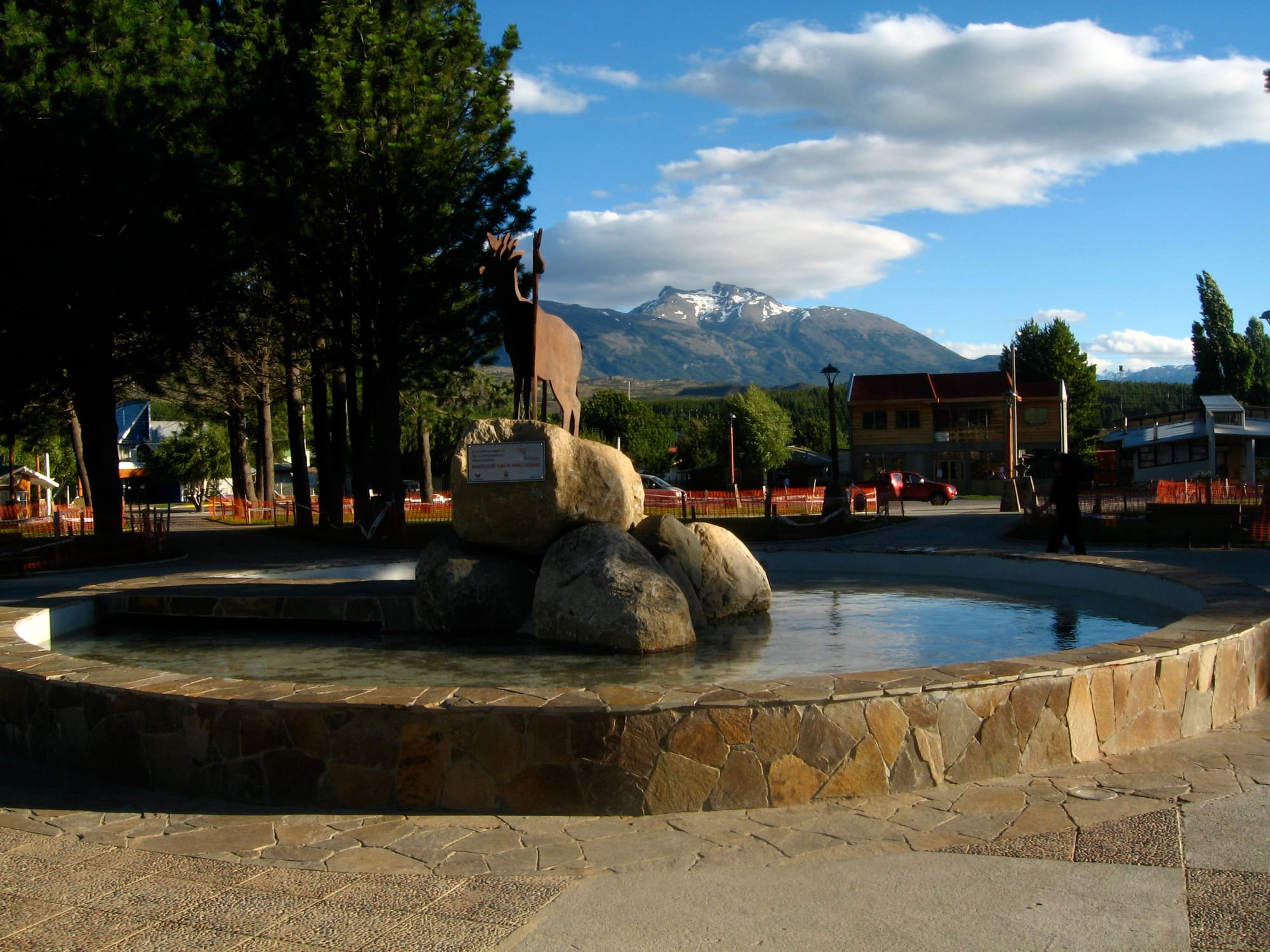
A fountain with a metal deer statue on boulders in a square of tall pines, with a snow-capped mountain beyond

Aysén & the Carretera Austral, Chile

Cochrane

The central plaza of Cochrane, with its pines and mountains rising behind the town. (Hector Garcia from Barcelona, Catalonia, Spain / Wikimedia Commons · CC BY-SA 2.0)

A small town in southern Aysén, in the valley of the Cochrane River, which flows into the Baker, Chile's largest river by volume. Founded in 1954 and cut off by road until 1988, it is the capital of Capitán Prat Province and the last sizeable town on the Carretera Austral, serving ranches, anglers and visitors to Patagonia National Park.

Neighbourhoods

  • The plaza and town centre
    • First-time visitors
    • Shops and supplies

    A grid of a few blocks around the central square, planted with tall pines, where the general store, bakery, small supermarket, tourist information kiosk, guesthouses and restaurants are found. It is the place to stock up before heading further south.

    Open in Maps
  • The Cochrane River banks
    • Quiet and residential
    • River views

    The town runs down to the Cochrane River, which flows from Cochrane Lake to the Baker. The edge of town opens straight onto pasture, forest and hills.

    Open in Maps

Things to do

In town

  • Plaza de Armaslandmark

    The tree-filled central square, ringed by the town's shops; its many pines were reportedly planted at the suggestion of Augusto Pinochet during one of his visits to the Carretera Austral.

    Open in Maps

Short trips from the town

  • Patagonia National Parkpark

    A national park created in 2018 from a former private reserve on old ranch land in the Chacabuco Valley, combined with the Jeinimeni and Lago Cochrane reserves, where steppe grassland meets southern beech forest; it has trails and campgrounds.

    Open in Maps
  • Cochrane Lakepark

    A deep glacier-fed lake shared with Argentina, where it is called Pueyrredón, about 10 km from town by road and known for its clear water and fishing; the short Cochrane River drains it into the Baker.

    Open in Maps
  • Baker Riverpark

    Chile's largest river by volume, coloured turquoise by glacial sediment, running past the Northern Patagonian Ice Field to the sea at Caleta Tortel; it was the site of the HidroAysén dam project, rejected after years of protests.

    Open in Maps
  • Monte San Lorenzoviewpoint

    A 3,706-metre granite massif on the Argentine border, also called Monte Cochrane, first climbed in 1943 and approached by climbers from the town.

    Open in Maps
  • Caleta Tortelattraction

    A village at the mouth of the Baker founded in 1955 to log Guaitecas cypress, with no conventional streets — only cypress-wood walkways linking stilt houses along the shore.

    Open in Maps

Eat and drink

Long-standing places and food districts in Cochrane. Hours, ratings and directions come from your maps app, always current.

Cochrane classics

  • Bakery and shops around the plazaneighborhood

    The bakery and general store on the square supply bread, pastries and picnic food for days on the road or in the park.

    Open in Maps
  • Restaurants in the town centreneighborhood

    A handful of family-run restaurants and cafés near the plaza serving Chilean set lunches, grilled meat, lamb and trout.

    Open in Maps

Experience Cochrane

History

Settlers reached the upper Baker valley in the early 20th century, and in 1927 a community called Río Baker was created, covering much of what is now Capitán Prat Province. In 1929, when the settlement stood at a place called Las Latas, the regional intendant set up a land commission to plan a town, and it was moved to a site in the Cochrane River valley about 7 km from Cochrane Lake, known as Pueblo Nuevo, the "new town", while it took shape.

The town was officially inaugurated on 17 March 1954, when a house built for the post office was completed; at the time it had ten houses. Its blocks and plots were finally laid out in 1955. It was later named after Thomas Cochrane, the British naval officer who became the first admiral of the Chilean Navy in 1818 and played a major part in winning independence from Spain. In 1970 it joined the new Baker department, and with the regional reforms of 1975 it became the capital of the renamed Capitán Prat Province.

For decades the town had no road link to the rest of Chile. That changed in 1988, when the Carretera Austral reached it. In the 21st century the area became a focus of environmental campaigns: the HidroAysén dam scheme on the Baker and Pascua rivers was opposed for years and rejected, and in 2018 the former private Parque Patagonia north of town became part of Patagonia National Park.

Culture & Customs

Cochrane's identity is that of a frontier ranching town. Cattle and sheep are raised on the plains around it, fed on the coirón bunchgrass of the steppe. The endangered huemul, the southern Andean deer, is the commune's emblem, and a metal deer stands in the fountain of the central plaza.

The town looks outward to its landscape. Its residents live with the Baker, the largest river in Chile by volume, with Cochrane Lake and with Monte San Lorenzo, the great granite peak on the Argentine border that climbers approach from here. Fishing, rafting, kayaking and horse riding are local pastimes as well as the basis of a growing tourist trade.

Conservation has become part of local life and debate. The campaign against dams on the Baker drew national attention, and the creation of Patagonia National Park, from former ranch land returned to grassland for guanacos and huemul, has brought new visitors and new jobs, while reshaping a landscape long devoted to livestock.

Daily Life

The commune had about 2,900 people at the 2002 census, most of them in the town, and covers a huge territory of mountains, lakes and glaciers. Cochrane is the capital of Capitán Prat Province and the service centre for the far south of Aysén, with a school and secondary school, a hospital, a bank, a fuel station, restaurants and lodging, and mobile phone coverage that arrived only recently.

The economy rests on cattle and sheep ranching, public services and, more and more, tourism, from fishing guides and rafting trips to the guesthouses and cabins that fill in summer. Food shops and lodging are among its main businesses.

Life is shaped by distance. Route 7, the Carretera Austral, is the only road, and in winter snow and flooding make the gravel tracks around town hard to maintain. Goods arrive from far away, and many errands mean a long drive north to Coyhaique.

Food

Cochrane eats as the ranches of Aysén do. Lamb roasted slowly on an iron cross beside an open fire, cordero al palo, is the dish for celebrations, and beef asado is nearly as common. Bread is often baked at home in wood-fired stoves, and tortas fritas, rounds of fried dough, go with mate, the bitter herbal drink shared from a gourd through a metal straw.

The lakes and rivers around town are known for trout and salmon, and fishing is one of the reasons visitors come. Calafate, the dark blue berry of a thorny Patagonian shrub, is made into jam and sweets, and rhubarb goes into jams and sauces; legend says that anyone who eats calafate will return to Patagonia.

Eating out means a handful of restaurants near the plaza with set lunches, grilled meat and fish, and the town's bakery, the usual stop for travellers stocking up before the road south.

Planning tools

Budget

Cochrane is expensive for its size: almost everything arrives by a long gravel road from the north, fuel costs more, and the choice of rooms is limited, with hospedajes, cabañas and a few hotels. Camping and self-catering keep costs down; guided fishing, rafting, horse riding and car hire are the big expenses.

Daily Budget Midrange
USD 120–240 (cabaña or small hotel, restaurant meals, guided excursions, a hire car)
Daily Budget Shoestring
USD 45–80 (camping or a hospedaje, self-catering, buses and hitchhiking)

Bring enough cash from Coyhaique and fill the tank here; cash machines and fuel are very limited further south.

Best Time to Visit

The summer season, when fly fishing, rafting, kayaking, lake trips, horse riding and wildlife watching are at their best and most services are open. Rain falls mostly from May to August, and in winter low temperatures bring snow, which can make the gravel roads hard going.

Suggested Number of Days

The town itself needs little time. How long to stay depends on the surroundings: the national park, the lake and river trips and the road to the coast each add a day or more, and bus connections along the Carretera Austral are infrequent.

First Visit
1–2 days
With Surroundings
3–5 days

Transportation

Route 7, the Carretera Austral, is the only road in the commune, linking Cochrane with Coyhaique to the north and Caleta Tortel and Villa O'Higgins to the south. Roads around town are gravel and corrugated, and can be flooded or snowbound in winter. Buses are infrequent, so many visitors drive, cycle or hitchhike, and the town is compact enough to cross on foot.

Drive slowly on the gravel, carry a spare tyre, and check road and bus conditions before setting out.

Airport & Station Connections

Most visitors fly from Santiago or Puerto Montt to Balmaceda, near Coyhaique, and continue south by road along the Carretera Austral, a long journey on partly gravel road. Cochrane also has a small airfield, and an air-taxi service flies in from Coyhaique.

Walkability

The centre is a few blocks around the plaza and easy to walk. Beyond that, sights are outside town and need a car, a bicycle or a guided trip, though the edge of town opens directly onto the countryside.

Safety

Chile is one of the safer countries in South America, but petty and opportunistic crime has risen, especially in Santiago and Valparaíso — pickpocketing, bag-snatching, phone theft, and distraction scams in tourist areas, markets, and on transport. In Cochrane the risks come from remoteness and weather: loose gravel on the roads, cold, fast rivers, sudden changes on the trails and long stretches without mobile coverage.

Register with park rangers before long walks, treat the Baker's currents with respect, and carry warm, waterproof clothing even in summer. Check current official travel advice before travelling.

Climate

An oceanic climate, sheltered from the heaviest Pacific rain by the Northern Patagonian Ice Field to the west, but still wet enough to support forest. Rain is concentrated from May to August, and winter brings snow; the gap between daily highs and lows is around 8–10°C all year.

Summer
December to February is the warm season, generally drier; the record high is 36.1°C, set in February 2019
Winter
June to August is cold, with snow; the record low is −16.2°C, set in July 1995

Local Customs

Cochrane is a ranching town with a frontier character, and life follows the rhythms of livestock and the seasons. The huemul, the endangered southern Andean deer, is the commune's symbol. Dress is practical and outdoor; mate is shared in many homes and workplaces.

Ask before photographing people or their animals, leave farm gates as they were found, and keep to marked trails in protected areas.

Common Payment Methods

The currency is the Chilean peso (CLP). The town has a bank, but cards are not accepted everywhere and cash machines are few, so carry enough pesos; south of Cochrane cash is harder still to obtain.