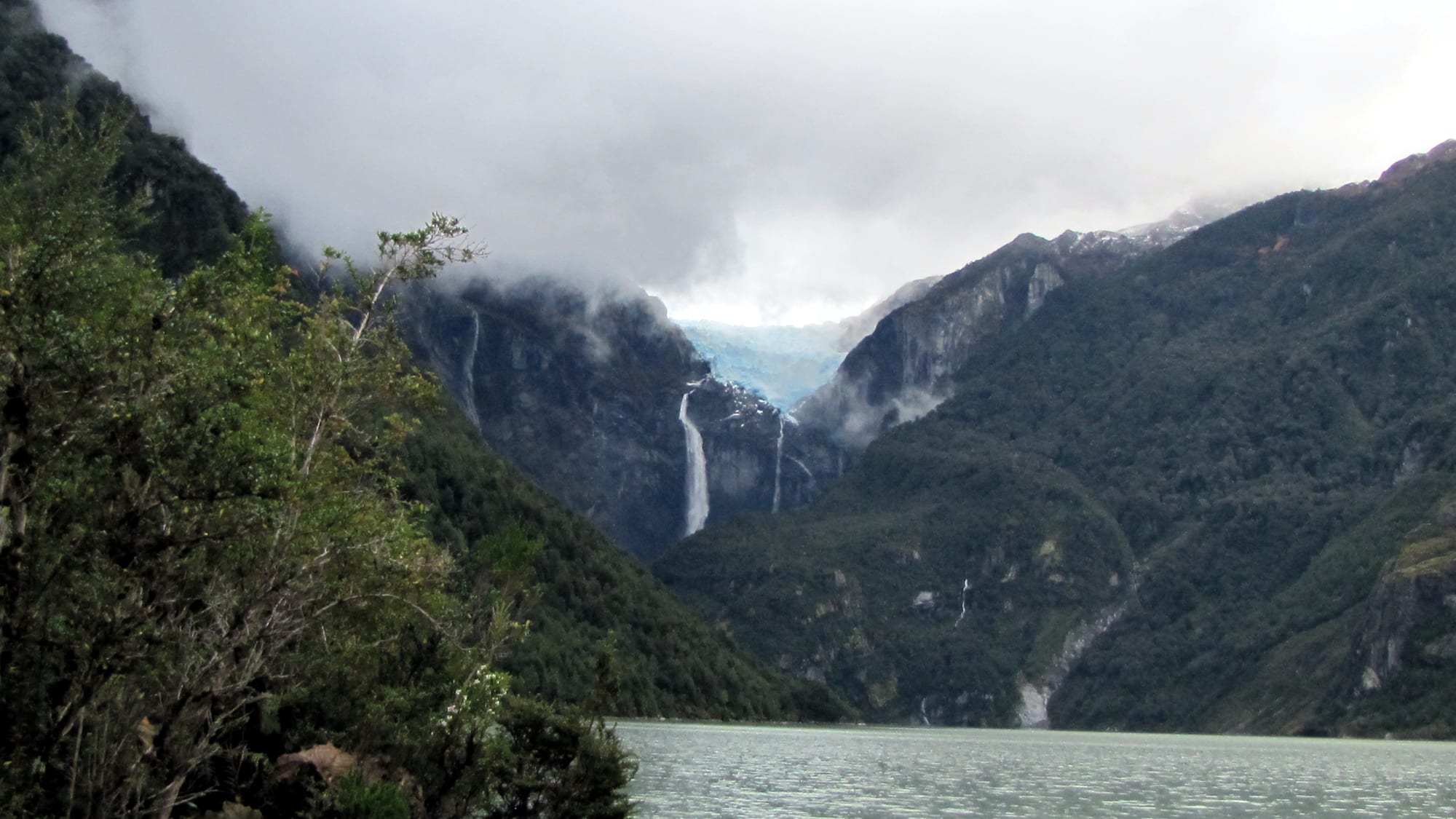
A blue hanging glacier and a long waterfall between steep forested mountains in cloud, above a grey-green lagoon

Chile

Aysén & the Carretera Austral

The Queulat hanging glacier seen from the Témpanos lagoon in Queulat National Park. (Lin linao / Wikimedia Commons · CC BY-SA 4.0)

Chile's least populated region, a wilderness of fjords, rainforest, glaciers and steppe between the Pacific and Argentina, strung along the Carretera Austral — a frontier settled only in the 20th century, centred on Coyhaique and known for the Marble Caves, the Northern Patagonian Ice Field and new national parks.

Explore Aysén & the Carretera Austral

History

For thousands of years Aysén was home to two very different peoples: the Tehuelche, or Aónikenk, hunters of guanaco on the eastern steppe, and the Chono, canoe nomads of the western channels and islands. European navigators charted the coast from the 16th century, and Jesuit missionaries from Chiloé travelled its channels, but no Spanish or Chilean town was founded here. The Chono disappeared as a distinct people during the colonial era.

Chile and Argentina settled much of the border through British arbitration in 1902, and the state then leased huge tracts to ranching companies, the largest being the Sociedad Industrial de Aysén. Settlers, many of them from Chiloé or Chileans returning from Argentina, cleared land by burning, and vast forest fires in the early 20th century left the silver dead trunks still seen on hillsides. Coyhaique grew from the 1920s as the service town of the steppe, and Puerto Aysén became the port, served today by nearby Puerto Chacabuco.

Until the late 20th century much of the region could be reached only by sea or through Argentina. Construction of the Carretera Austral began in 1976 under the military government and reached Villa O'Higgins in 2000. Since then Aysén has become a centre of Chilean environmental politics: a large hydroelectric project on the Baker and Pascua rivers was rejected in 2014 after years of protests, and the donation of private conservation lands helped create Patagonia National Park in 2018.

Culture & Customs

Aysén's culture is Patagonian rather than central Chilean. Its rural figure is the gaucho-like pioneer on horseback, and much of its way of life came from Argentina: mate is drunk from a shared gourd through a metal straw, sheep and cattle are central, and lamb roasted on an iron cross over an open fire is the dish of every celebration. Rodeos, horse races, jineteadas and sheep-shearing competitions fill the summer calendar.

The settlers' descendants cultivate an identity as pioneers who built the region without much help from Santiago, a feeling that surfaced in the 2012 protests over fuel prices and the cost of living. Chilote traditions — minga work parties, shingled houses, wood-stove kitchens — came with the many settlers from Chiloé.

Puyuhuapi, founded in the 1930s by German-speaking Sudeten settlers, was long known for its carpet factory, and in Coyhaique and Chile Chico local fiestas mix Chilean and Argentine music.

Daily Life

Aysén has only about 100,000 people in a territory larger than many European countries. More than half live in Coyhaique, the regional capital, a grid town of about 60,000 set among hills with a pentagonal plaza at its centre. Puerto Aysén is the second town, and Chile Chico, Cochrane, Puerto Cisnes and La Junta are small service centres; Caleta Tortel and Villa O'Higgins have a few hundred people each.

The economy rests on public employment, cattle and sheep ranching, salmon farming and fishing in the fjords around Puerto Aysén and Puerto Cisnes, some mining, and a growing tourism sector centred on fly-fishing, trekking and the Carretera Austral. Chile Chico's orchards grow fruit in its sheltered microclimate.

Distance governs life: goods arrive by long road or ferry, prices run higher than in the north, many patients travel to Puerto Montt or Santiago for specialist care, and in winter wood smoke from home stoves makes Coyhaique's air among the most polluted in the country.

Food

Aysén cooking is ranch food. Cordero al palo, lamb split and roasted for hours beside an open fire, is the centrepiece of any gathering, and beef asado is nearly as common. Tortas fritas, fried dough, and sopaipillas go with mate, and bread is often baked at home in wood-fired stoves.

The coast brings merluza austral, the southern hake, as well as mussels, clams and farmed salmon, and the lakes and rivers are known for trout and salmon fishing. Wild calafate berries, the dark blue fruit of a thorny shrub, and rhubarb go into jams, sweets and sauces; legend says that whoever eats calafate will return to Patagonia.

Drinks are mate, strong tea and a growing number of craft beers brewed in the region, alongside wine brought from the north.

Attractions & Natural Wonders

The Carretera Austral itself is the region's great journey, entering Aysén from the north near La Junta and running south past rainforest, lakes and glaciers to Villa O'Higgins, where the road ends and a boat-and-foot route continues into Argentina. In the north, Queulat National Park has its hanging glacier above the Témpanos lagoon, and nearby Puyuhuapi has hot springs on the fjord.

Coyhaique is the base for the centre of the region, with the Coyhaique National Reserve on its edge and Cerro Castillo National Park about an hour and a half to the south. From Puerto Chacabuco and Puerto Río Tranquilo, boat and road trips reach Laguna San Rafael, the Exploradores glacier and the Northern Patagonian Ice Field, whose Monte San Valentín is the highest mountain in Chilean Patagonia.

Lake General Carrera, Chile's largest lake, shared with Argentina, has the Marble Caves — the Marble Chapel and Marble Cathedral among them — reached by boat from Puerto Río Tranquilo, and the road along its southern shore to Chile Chico. Further south, the turquoise Baker river runs past Cochrane, near the steppe and lakes of Patagonia National Park, to Caleta Tortel and its boardwalks.

Cities in Aysén & the Carretera Austral

Planning basics

Budget

Aysén is expensive for Chile: almost everything arrives by long road or ferry, fuel costs more, and lodging is limited, so prices in the small villages can exceed Coyhaique's. Camping and simple hospedajes keep costs down; boat trips to the Marble Caves and Laguna San Rafael, guided glacier walks and car hire are the big expenses.

Daily Budget Midrange
USD 130–260 (lodges and cabañas, restaurant meals, boat excursions, a 4x4 or hire car)
Daily Budget Shoestring
USD 45–80 (camping or hospedajes, self-catering, buses and hitchhiking)

Carry cash and fill the tank at every chance; cash machines and fuel stations are far apart south of Coyhaique.

Safety

Crime is very low. The risks here are remoteness and weather: loose gravel and blind bends on the Carretera Austral, landslides after heavy rain, strong winds on the lakes, cold rivers, sudden weather changes on the trails, long stretches without mobile coverage and limited medical care outside Coyhaique.

Drive slowly on gravel, register with park rangers before multi-day treks, and carry warm, waterproof clothing even in summer. Check current official travel advice before travelling.

Climate

Two climates side by side. The coastal fjords and western valleys are cool and extremely wet, with rain much of the year, while the east, around Coyhaique, Chile Chico and Cochrane, lies in the rain shadow of the Andes and is drier, sunnier and colder in winter. Chile Chico, on Lake General Carrera, is noted for a mild microclimate. Wind is constant.

Summer
cool to mild, 12–22°C, long days and changeable weather
Winter
cold, often below freezing inland, with snow in Coyhaique and on the passes; wet and grey on the coast

Transportation

Flights from Santiago and Puerto Montt land at Balmaceda, about an hour from Coyhaique. Car ferries from Puerto Montt and Chiloé reach Puerto Chacabuco. The Carretera Austral, partly paved and partly gravel, runs north to south through the region with lake and fjord ferry crossings further south; buses are infrequent, so many visitors rent a car, cycle or hitchhike. A ferry crosses Lake General Carrera to Chile Chico.

Allow far more time than the distances suggest, carry a spare tyre, and check ferry schedules and road works before setting out.

Best Time to Visit

December to March, when roads and ferries run most often, lodgings are open and the days are long. November and April are quieter but colder, and some services close. Winter is for the determined: snow, short days and limited transport, though Coyhaique stays open year-round.