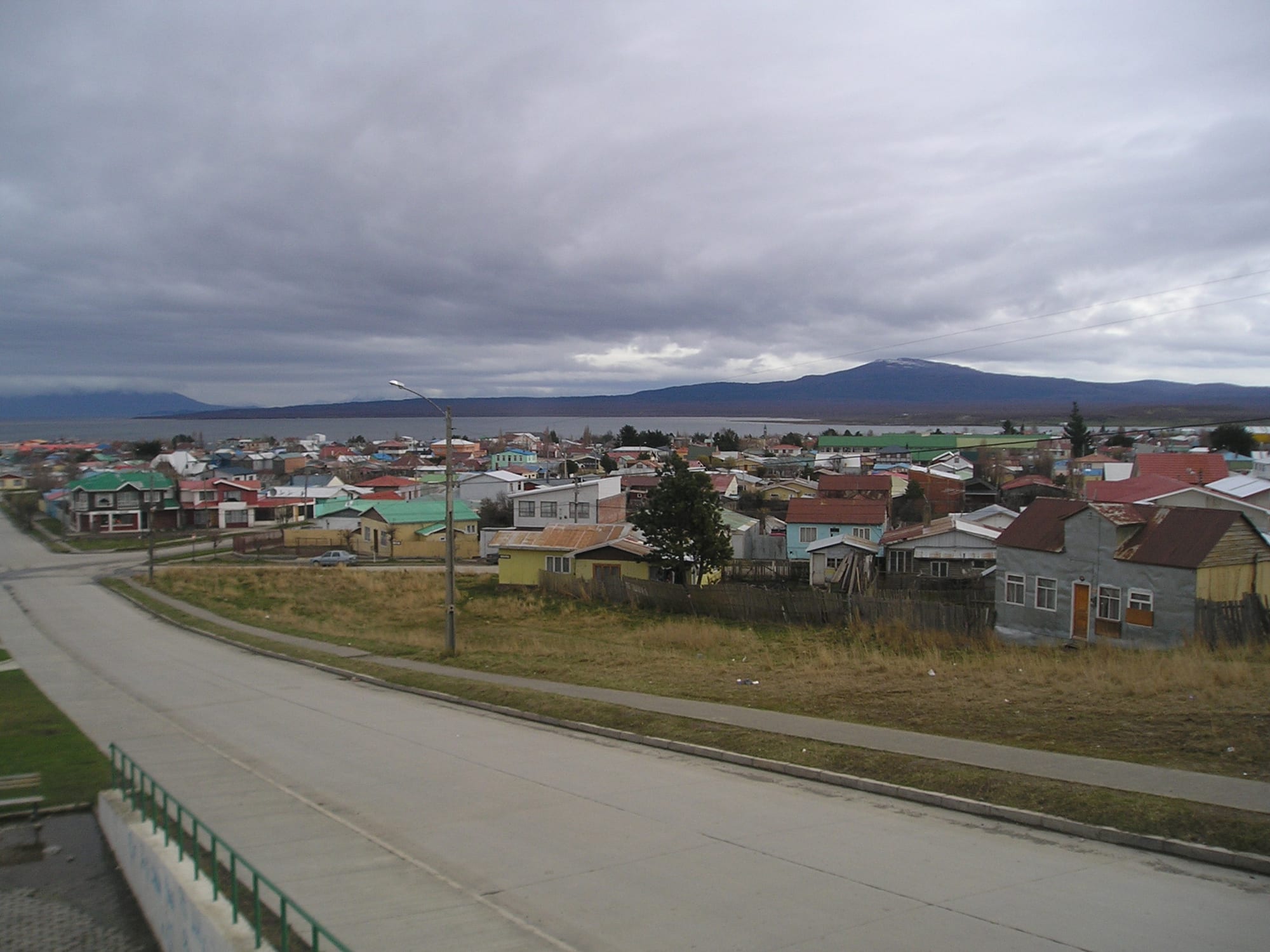
Low houses with colourful tin roofs spread down to a grey sound, with a long dark mountain ridge across the water

Torres del Paine & Magallanes, Chile

Puerto Natales

Puerto Natales seen from a hill above the town, looking across to the mountains beyond the water. (User:Heretiq / Wikimedia Commons · CC BY-SA 2.5)

A small port town on the Señoret Channel at the mouth of Última Esperanza Sound in Chilean Patagonia, founded in 1911 to serve the sheep-farming industry. Settled largely by migrants from Chiloé, it declined with the wool trade and has been remade by tourism as the main base for Torres del Paine National Park, with hostels, outfitters and fjord boat departures.

Neighbourhoods

  • The centre and Plaza de Armas
    • First-time visitors
    • Restaurants
    • Outfitters

    Most services sit in a triangle formed by Manuel Bulnes, Pedro Montt and Bernardo Philippi streets. The Plaza de Armas, between Eberhard and Bories, is ringed by the municipal buildings, the church, the post office, pubs and restaurants, and the town museum is on Bulnes.

    Open in Maps
  • The waterfront (Costanera)
    • Sound views
    • Walking
    • Ferries

    Pedro Montt Avenue runs along the shore of the Señoret Channel, with the Navimag pier and a naval pier where benches face the water and the mountains beyond. Boat trips into the fjords leave from the town's pier.

    Open in Maps
  • The upper town (Sector Alto)
    • Quiet and residential
    • Views

    Up Miraflores street the residential streets climb to Santiago Bueras Avenue, with wide views over the low roofs of the town to the sound and the surrounding mountains.

    Open in Maps

Things to do

In town

  • Plaza de Armaslandmark

    The large open main square between Eberhard and Bories streets, framed by the municipal buildings, the church and the post office.

    Open in Maps
  • Museo Histórico Municipalmuseum

    The town museum on Bulnes, with natural history displays, artefacts of the Kawésqar and Aónikenk peoples and photographs of the town's growth.

    Open in Maps
  • The boatyardattraction

    About a kilometre south of the Navimag pier along Pedro Montt, where wooden fishing boats are hauled ashore for painting and repair, or left to rest.

    Open in Maps
  • Puerto Borieslandmark

    The company town of the Bories cold-storage plant, which processed sheep meat and wool for Europe from the 1910s until 1993; its industrial buildings and British machinery have been restored, with a museum of the plant's history.

    Open in Maps

Short trips from the town

  • Última Esperanza Soundviewpoint

    The 'Last Hope' inlet named in 1557 by the navigator Juan Ladrillero, whose waters, with the Señoret Channel, form the boat route from Natales to the region's fjords and protected areas.

    Open in Maps
  • Mirador Doroteaviewpoint

    A walk of about two hours there and back to a viewpoint in the Dorotea hills, about 900 metres high, looking over the town, the glacial valley and the mountains.

    Open in Maps
  • Cueva del Milodón Natural Monumentattraction

    Caves on the flanks of Cerro Benítez, 24 km north-west of town, where skin and bones of the extinct giant ground sloth Mylodon were found in 1895, with a rock formation called the Devil's Chair and an interpretive trail.

    Open in Maps
  • Torres del Paine National Parkpark

    One of Chile's largest and most visited national parks, around the granite towers and horns of the Paine massif, with glaciers, lakes and steppe in a UNESCO biosphere reserve.

    Open in Maps

Eat and drink

Long-standing places and food districts in Puerto Natales. Hours, ratings and directions come from your maps app, always current.

Puerto Natales classics

  • Lamb grillsrestaurant

    Parrillas in the town grill Patagonian lamb, the region's signature meat, alongside beef.

    Open in Maps
  • Seafood restaurantsrestaurant

    Fish and shellfish from the cold southern waters, including centolla, the southern king crab, appear on many menus.

    Open in Maps

Food districts

  • Eberhard and Bulnes streetsneighborhood

    The streets around the main square hold many of the town's restaurants, cafés and pubs, many of them aimed at trekkers fresh from the park.

    Open in Maps

Experience Puerto Natales

History

The Kawésqar, canoe people of the channels, and the Aónikenk, or Tehuelche, hunters of the steppe, lived around the sound long before Europeans arrived. The Spanish navigator Juan Ladrillero entered it in 1557 while searching for a western approach to the Strait of Magellan and called it Última Esperanza, his "last hope". Nearly three centuries later, in 1830, the British survey ship HMS Beagle charted these fjords, and its officers are remembered in local place names. From the 1870s explorers and travellers ventured inland, among them the English writer Lady Florence Dixie, who described the first tourist journey to the Paine towers.

Sheep transformed the area at the end of the 19th century. European immigrants — Germans, British, Croats, Greeks, Italians and Spaniards — were followed by Chileans, many from Chiloé, and the town was formally founded on 31 May 1911 as a port for the sheep industry. The Sociedad Explotadora de Tierra del Fuego built a cold-storage plant at Puerto Bories, about 5 km away, which froze and shipped meat and wool to Europe until 1993. In 1919 a strike by the Magallanes workers' federation briefly put the workers in control of the town before it was suppressed by the government.

In the second half of the 20th century the sheep industry declined, and many people from Natales went to work in the coal mines of Río Turbio, across the border in Argentina. Tourism to Torres del Paine, and later aquaculture, revived the town, and its population has grown again since 2002.

Culture & Customs

Puerto Natales is above all a Chilote town at the far end of Patagonia. Migrant workers from the island of Chiloé arrived in large numbers, drawn by the sheep industry, and their cooking, building style and customs still mark the town, alongside many families of British and Croatian descent. The town also has strong left-wing political affiliations.

The town's culture reflects its double life as a working port and a trekking base. The municipal museum keeps the memory of the Kawésqar and Aónikenk and of the pioneer era, the Bories plant preserves its British machinery as industrial heritage, and craft shops sell sheepskin, woodwork, wool sweaters, and mate gourds with bombillas.

Life faces outward to the landscape. Boat trips sail the fjords to view glaciers and icebergs, horse rides visit the estancias around town, and kayaks explore the sound. Above all, Puerto Natales is defined by Torres del Paine, whose three granite towers rise 2,500 metres and draw hundreds of thousands of visitors a year, many of whom pass through the town on the way.

Daily Life

The city had about 21,500 people at the 2017 census, and it is the only city in the vast, thinly populated province of Última Esperanza. The commune of Natales covers nearly 49,000 square kilometres, larger than seven of Chile's regions, and men outnumber women noticeably. Growth since 2002 has been tied to the expansion of tourism and of aquaculture.

Tourism is now one of the most important industries, with dozens of campsites, hostels, hotels, restaurants and transport services, but cattle farming and fish farming also matter. Despite wind, cold and thin soils, a little local produce is grown, including courgettes, cherry tomatoes, strawberries, cucumbers and carrots.

The year swings between a busy summer, when outfitters, guesthouses and buses fill with trekkers, and a quiet winter of short days and rain or snow. The town has more rainy days than any other Chilean city. Supermarkets supply trekkers and residents alike, and the regional capital, Punta Arenas, lies 247 km to the south-east.

Food

Puerto Natales shares the cooking of Magallanes. Cordero magallánico, lamb raised on the steppe and roasted for hours beside an open fire, is the centrepiece of gatherings, and grills in town serve lamb alongside beef. From the cold southern waters come centolla, the southern king crab, its smaller cousin centollón, sea urchins, mussels and southern hake.

The Chilote heritage of many families shows in the town's home cooking, which draws on the traditions of the archipelago far to the north. Calafate, the dark blue berry of a thorny Patagonian shrub, flavours jam and ice cream, and local legend says that whoever eats it will return to Patagonia. Mate is common in homes.

Trekking shapes how the town eats as well. Supermarkets stock dried fruit and nuts, soups and noodles for days on the trail, while the restaurants and pubs around the plaza serve hearty meals and beer to walkers returning from the park, and beer has long been brewed in the region, where craft labels have joined the old brewery in Punta Arenas.

Planning tools

Budget

Puerto Natales is cheaper than staying inside Torres del Paine, and it has hostels, campsites and budget restaurants as well as smart hotels. Prices rise sharply in the December–February peak. Park entry, transport to the park, boat trips and refugio or campsite bookings are the big costs, and supermarkets here are the last place to buy food at reasonable prices before the park.

Daily Budget Midrange
USD 160–300 (hotel, restaurant dinners, park tours or a hire car, a fjord boat trip)
Daily Budget Shoestring
USD 55–95 (hostel bed, supermarket food, buses to the park)

Book park campsites and refugios well ahead for the summer circuits, and stock up on trekking food in town.

Best Time to Visit

October to April, the southern spring and summer, has more sunny days, less rain and very long daylight, and Torres del Paine is busiest from December to February. Late spring and summer can be very windy. Winter is quiet, with fewer flights and services, though the park stays open.

Suggested Number of Days

The town needs only a day or two. Most visitors stay longer because they use it as a base, and the total depends on whether they make day trips or walk a multi-day trek in the park, and on the weather.

First Visit
1–2 days
With Surroundings
4–7 days

Transportation

There are no city buses; shared taxis called colectivos run fixed routes, and ordinary taxis are unmetered, so the fare is agreed in advance. Buses and tours to Torres del Paine, and to El Calafate and El Chaltén in Argentina, leave through agencies in town. Hitchhiking is common towards the park and the Milodon Cave.

The bus terminal is a little way from the centre; a colectivo is the cheap way to reach it.

Airport & Station Connections

Teniente Julio Gallardo Airport, 7 km north-north-west of town, has flights in the high season from Santiago and Puerto Montt. Most visitors fly to Punta Arenas, 247 km to the south-east, and take one of several daily buses, about three hours. Buses also run from El Calafate in Argentina, about six hours. Navimag's weekly ferry from Puerto Montt ends here after sailing through the fjords via Puerto Edén, and since 2016 a ferry has run via Puerto Edén to Tortel and Puerto Yungay in Aysén.

Walkability

A small waterside town that is easy on foot: the centre, the plaza and the waterfront are a few minutes apart, and the shore path along Pedro Montt is the pleasant way to cover ground. The bus terminal is about a ten-minute walk from the centre, and the wind can make walking hard work.

Safety

Chile is one of the safer countries in South America, but petty and opportunistic crime has risen, especially in Santiago and Valparaíso — pickpocketing, bag-snatching, phone theft, and distraction scams in tourist areas, markets, and on transport. Crime is low in Puerto Natales itself; the dangers are natural: violent wind, cold water and sudden storms on the trails of Torres del Paine, where fires started by visitors have caused major wildfires.

Carry warm, waterproof layers even on day walks, stay on marked trails and follow the park's fire rules strictly. Check current official travel advice before travelling.

Climate

An oceanic climate with cool, short summers and chilly, wet winters. Puerto Natales has the most rainy days per year of any city in Chile, about 161, and the weather can show four seasons in a day, with strong wind in late spring and summer.

Summer
December to February is summer — cool and windy, around 8–18°C across Magallanes, with daylight late into the evening
Winter
June to August is cold, around -2 to 5°C across Magallanes, with snow and ice and short days

Local Customs

Much of the population descends from migrants from Chiloé, and Chilote habits show in the cooking and building style; British and Croatian surnames are common too. The town has strong communist and left-wing affiliations, and politics can be a sensitive topic of conversation. Dress is outdoor and practical.

Fruit, vegetables and animal products may not be brought into Chile from Argentina; declare food at the border to avoid fines.

Common Payment Methods

The currency is the Chilean peso (CLP). Cards are widely accepted in hotels, restaurants and supermarkets, and there is a bank on the Plaza de Armas; taxis and small shops may want cash, and cash is useful for park transport and campsites.