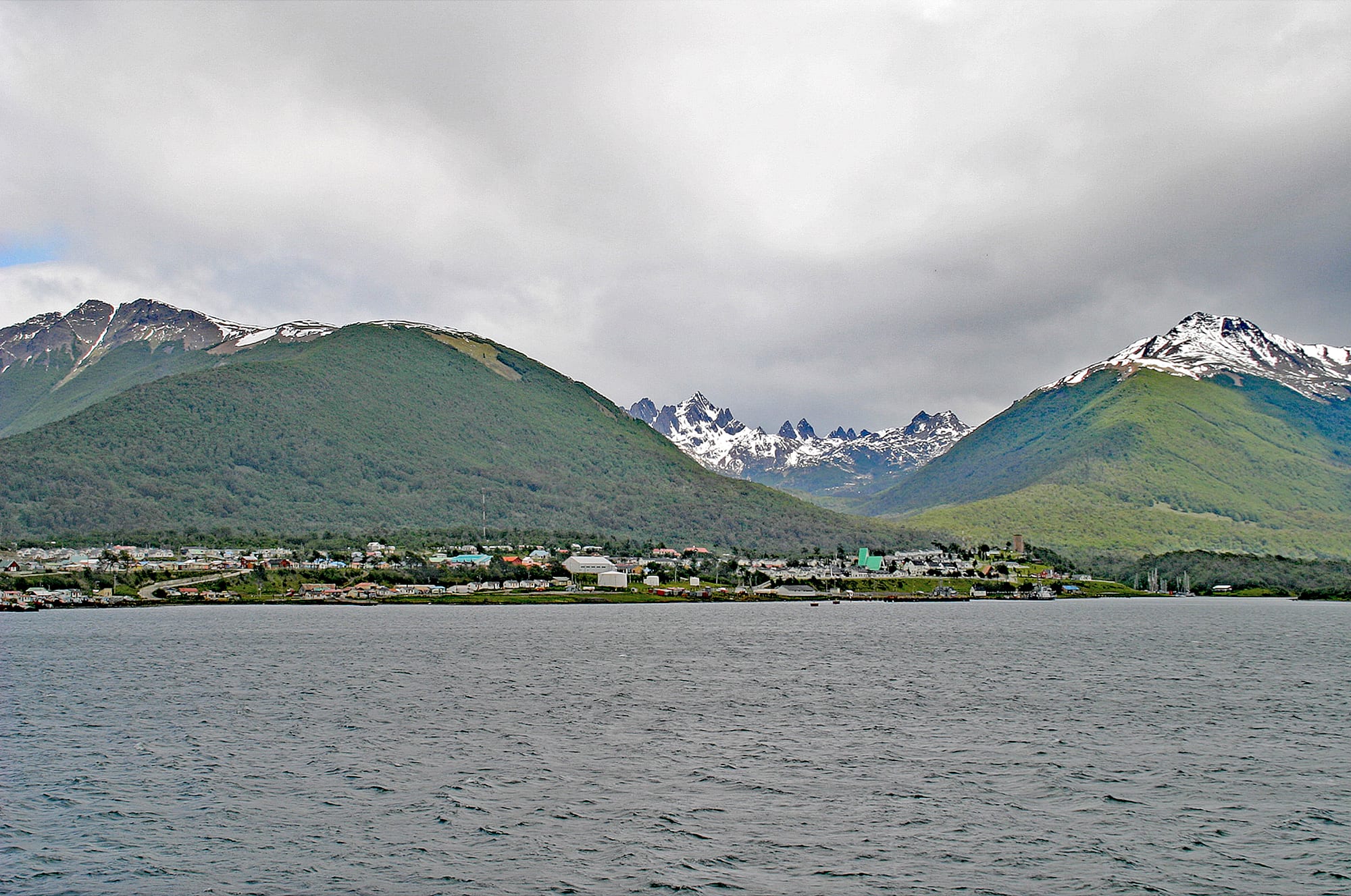
A low line of houses along the shore of grey water, below forested green hills and snow-streaked jagged peaks

Torres del Paine & Magallanes, Chile

Puerto Williams

Puerto Williams on the Beagle Channel, with the Dientes de Navarino behind the town. (W. Bulach / Wikimedia Commons · CC BY-SA 4.0)

A small port and naval base on the north shore of Navarino Island, facing the Beagle Channel below the jagged Dientes de Navarino. Founded in 1953 for the Chilean Navy, it is the capital of the Chilean Antarctic Province, home to a Yaghan community, and now a base for trekkers, scientists, yachts and expedition cruises heading for Cape Horn and Antarctica.

Neighbourhoods

  • The waterfront and naval district
    • First-time visitors
    • Historic buildings
    • Sailing

    The historical core of the town since 1953, along the Beagle Channel shore. The old Navy ship Micalvi, now a yacht club, sits at the water's edge beside the Beagle Naval District buildings, the piers for fishing boats, cruise and research vessels, and the ferry ramp.

    Open in Maps
  • The upper town
    • Views
    • Science and research
    • Quiet and residential

    One- and two-storey timber houses with metal cladding climb the slope behind the shore in a long, linear town. Higher up stands the Cape Horn Sub-Antarctic Center, opened in 2022, with views over the channel and towards the Dientes.

    Open in Maps
  • Villa Ukika
    • Indigenous culture
    • Quiet and residential

    A small settlement beside the Ukika river about 2 km east of the centre, where descendants of the last Yaghan people live. It forms a neighbourhood joined to the town, with housing and community amenities.

    Open in Maps

Things to do

In town

  • Yagan Usi Territorial Museummuseum

    Formerly the Martin Gusinde Anthropological Museum, with artefacts, maps and photographs covering the 10,000-year history of the Yaghan people and the European settlers who followed, plus displays on local wildlife.

    Open in Maps
  • The Micalvilandmark

    A former Chilean Navy auxiliary vessel, decommissioned in 1961 and anchored in Puerto Williams the same year, declared a historical ship and long used as a meeting place for yachts.

    Open in Maps

Walks and nature

  • Cerro Banderatrail

    A hill above town crowned by a Chilean flag, about three hours there and back on foot, and the first stage of the Dientes de Navarino circuit.

    Open in Maps
  • Omora Ethnobotanical Parkpark

    A research and conservation area about 4 km west of town, known for 'ecotourism with a hand-lens' — looking closely at the mosses, lichens and other small plants of the sub-Antarctic forest.

    Open in Maps
  • Dientes de Navarinotrail

    The range of jagged, tooth-like peaks just south of town, circled by a rough trekking route that takes five to seven days depending on the weather.

    Open in Maps

Short trips from the town

  • Puerto Navarinoattraction

    One of the southernmost populated places in Chile, a small port on the Beagle Channel directly opposite Ushuaia in Argentina.

    Open in Maps

Seasonal events

  • Glorias Navales Regattalast week of May

    A sailing race that sets out from the port along the fjords, part of the Chilean Navy's Month of the Sea commemorating the Naval Battle of Iquique of 1879.

  • Fiesta de la NieveJuly

    A six-day snow festival marking winter, with snow games, cars and rodeo.

Eat and drink

Long-standing places and food districts in Puerto Williams. Hours, ratings and directions come from your maps app, always current.

Eating in Puerto Williams

  • Town restaurants and cafésneighborhood

    Roughly twenty places to eat and drink — restaurants, cafés, bars and a pastry shop — spread through a town where king crab from the local fishery is the prized catch.

    Open in Maps
  • Supermarketsmarket

    A few small supermarkets supply trekkers and residents; the choice of fresh fruit and vegetables depends on the arrival of the ferry from Punta Arenas.

    Open in Maps

Experience Puerto Williams

History

The Yaghan, canoe people who hunted sea lions and gathered shellfish among the islands south of Tierra del Fuego, are believed to have lived in this area for more than 10,000 years, making them the world's southernmost Indigenous population. Europeans first encountered them in the 16th century, but outsiders took real interest only in the 19th, when whaling ships called and gold was found on the islands to the east: by 1890 about 300 miners were working Picton, Lennox and Nueva islands, and Puerto Toro was founded in 1892. Some islands were later turned over to sheep ranching.

Puerto Williams itself was founded in 1953 as a Chilean naval base, first under the name Puerto Luisa. It was later renamed after John Williams Wilson, the British-born founder of Fuerte Bulnes, the first settlement on the Strait of Magellan. The Navy built the first houses and offices — Naval House No. 1 of 1953 and the Beagle Naval District headquarters of 1954 are now listed as historic monuments — and opened a naval hospital in 1960. In 1961 the old Navy vessel Micalvi was anchored here. During the Beagle conflict with Argentina, trenches and defences were dug around the area, and under the 1984 Treaty of Peace and Friendship Puerto Williams became the starting point for ships of all nations travelling between the Strait of Magellan and the Argentine ports of the Beagle Channel.

Since the late 20th century the number of Navy personnel has fallen while the civilian population has grown. In 2005 the area became part of the UNESCO Cape Horn Biosphere Reserve, the Cape Horn Sub-Antarctic Center opened in 2022, a new multipurpose pier entered service in 2023 and a new airport passenger terminal was completed in 2024.

Culture & Customs

Puerto Williams claims the title of the world's southernmost city, and its tourism has grown around that idea. The claim is disputed: some point to the town's small size and favour Ushuaia or Punta Arenas instead. Since 2019, when Chile's statistics institute began counting every provincial capital as a city, it has officially been one in Chile.

Yaghan culture is central to the town's identity. Cristina Calderón, born on Navarino Island in 1928, was known as the last full-blooded Yaghan and one of the last native speakers of the Yaghan language; she lived at Villa Ukika and died in 2022, when the region declared three days of mourning, and the town's community hospital now bears her name. The Yagan Usi Territorial Museum tells the Yaghan story alongside that of missionaries and settlers, and the 19th-century Stirling House, a prefabricated Anglican dwelling moved here by way of the Falkland Islands, stands beside it. Remains of Yaghan camps and fish traps survive along the eastern shore.

Navy traditions shape the calendar. The Glorias Navales Regatta in late May belongs to the Navy's Month of the Sea, and July's Fiesta de la Nieve fills six days with snow games and rodeo — the town has its own rodeo arena. The yacht club on the Micalvi gathers sailors bound for Cape Horn and Antarctica.

Daily Life

The 2017 census counted about 1,900 people in Puerto Williams, the fourth-largest settlement in the region, and about 18 per cent of residents identified with an Indigenous people, mostly Mapuche and Yaghan. The largest age group is working-age adults — naval personnel, public officials and service workers — while many young people leave for higher education elsewhere.

The economy rests on four pillars: the Navy base, artisanal fishing for southern king crab, conservation-minded tourism, and public services, which employ more than a third of the workforce as the town administers the province and the communes of Cabo de Hornos and the Chilean Antarctic Territory. Thousands of hikers and cruise passengers arrive each year, and expedition cruises using the town as a gateway to Antarctica have increased since the 2024–25 season. The University of Magallanes has a centre here, and the town supplies the weather stations and lighthouses at Cape Horn and the Diego Ramírez Islands.

Life revolves around supply. Fresh produce depends on the ferry from Punta Arenas, goods cost more than elsewhere in Chile, and expectant mothers usually travel to Punta Arenas to give birth. The town has 5G internet over a submarine fibre-optic link. Beavers, introduced to Tierra del Fuego in the mid-20th century, have flooded and destroyed native beech forest on Navarino, and control and restoration programmes are part of local work.

Food

The food of Puerto Williams starts with the sea. The artisanal fishery for centolla, southern king crab, begins each July and is an important source of household income and of exports from the region; the Navy's presence here is partly to protect fishing rights for the crab in the waters around southern Tierra del Fuego. Across Magallanes, the cold waters also supply centollón, a smaller crab, sea urchins, mussels and southern hake.

On land, the town shares the food of the wider region: cordero magallánico, lamb roasted for hours beside an open fire at gatherings, and calafate, the dark blue berry of a thorny Patagonian shrub, used in jams and ice cream — local legend says whoever eats it will return. Croatian and German settlers brought cakes and pastries to Magallanes, and the town has a pastry shop among its roughly twenty places to eat and drink.

Self-catering takes planning. The supermarkets' range of fruit and vegetables follows the arrival of the ferry, with canned goods and frozen meat filling the shelves in between, so trekkers usually bring supplies with them.

Planning tools

Budget

Puerto Williams is an expensive place to visit. Because of its isolation, goods and services cost more than elsewhere in the country and in Magallanes, and getting there by air from Punta Arenas or by boat from Ushuaia is a large part of the budget. Lodging is mostly hostels and a small number of hotels, and there is a campground.

Daily Budget Midrange
USD 170–320 (hotel or guesthouse room, restaurant meals, guided trekking or boat trips)
Daily Budget Shoestring
USD 60–100 (hostel bed or camping, supermarket food, walking)

Trekkers should bring most of their gear and specialist food with them, since the shops carry a limited range at high prices.

Best Time to Visit

The southern summer, roughly November to March, is the season for trekking, sailing and expedition cruises, with December to February the warmest months and the longest days. Snow can fall even in summer. In winter the town is quiet, with the snow festival in July.

Suggested Number of Days

Two or three days cover the town and its short walks. The full trek around the Dientes takes five to seven days on its own, and weather can delay flights, boats and treks, so spare days are worth building in.

First Visit
2–3 days
With Surroundings
6–9 days

Transportation

There is no formal public transport. The town is small enough to walk, and minibuses carry visitors across the island, including along the gravel road west to Puerto Navarino. Trails start close to town.

Boats and planes depend on the weather in the Beagle Channel and the Drake Passage region; allow slack in any onward plan.

Airport & Station Connections

Aerovías DAP flies from Punta Arenas to Guardia Marina Zañartu Airport, the world's southernmost airport with regular scheduled flights, whose runway lies on a small peninsula along the shore. The vehicle ferry Yaghan sails from Punta Arenas, 350 km to the north, in a voyage of about 32 hours, once or twice a week depending on the season. From Ushuaia in Argentina there is no official ferry, but private operators combine a boat crossing of the Beagle Channel to Puerto Navarino with a road transfer to town.

Walkability

The town is a narrow strip along the shore and easy to walk from end to end, with Villa Ukika and the Omora park within walking distance. The wind, rain and cold are the main obstacles, and paths beyond town quickly become rough mountain trails.

Safety

Puerto Williams is a small, closely knit naval and civilian town. The real dangers are natural: sudden storms, cold and wet weather even in summer, river crossings and rough ground on the Dientes circuit, and an earthquake and tsunami risk — a strong earthquake in the Drake Passage in May 2025 prompted a precautionary tsunami alert and temporary coastal evacuations.

Chile is one of the safer countries in South America, but petty and opportunistic crime has risen, especially in Santiago and Valparaíso — pickpocketing, bag-snatching, phone theft, and distraction scams in tourist areas, markets, and on transport. On the island, carry full waterproof and warm gear on any walk and follow tsunami evacuation signs near the shore. Check current official travel advice before travelling.

Climate

A subpolar oceanic climate bordering on tundra. Summer is December to February. Summers are short and cool, winters long and wet but moderate, and temperatures are fairly steady through the year. Rainfall is around 510 mm a year, and snow can fall in summer.

Summer
short and cool — the warmest month on the northern coast of Navarino averages about 10°C, and snow is possible even in December to February
Winter
long and wet but moderate — the coldest month on the northern coast averages about 2°C, with snow and short days

Local Customs

Puerto Williams is a small community of Navy families, public servants, fishermen and Yaghan descendants, where most people know one another. Dress is practical for the weather and greetings are friendly and informal. The Yaghan community at Villa Ukika is a residential neighbourhood rather than a sight.

Ask before photographing people, especially in Villa Ukika, and avoid photographing naval installations.

Common Payment Methods

The currency is the Chilean peso (CLP). The town has branches of Banco de Chile and, since 2025, BancoEstado. Cards are widely accepted in Chile, but cash is useful in small places like this, and prices are higher than in the rest of the region.