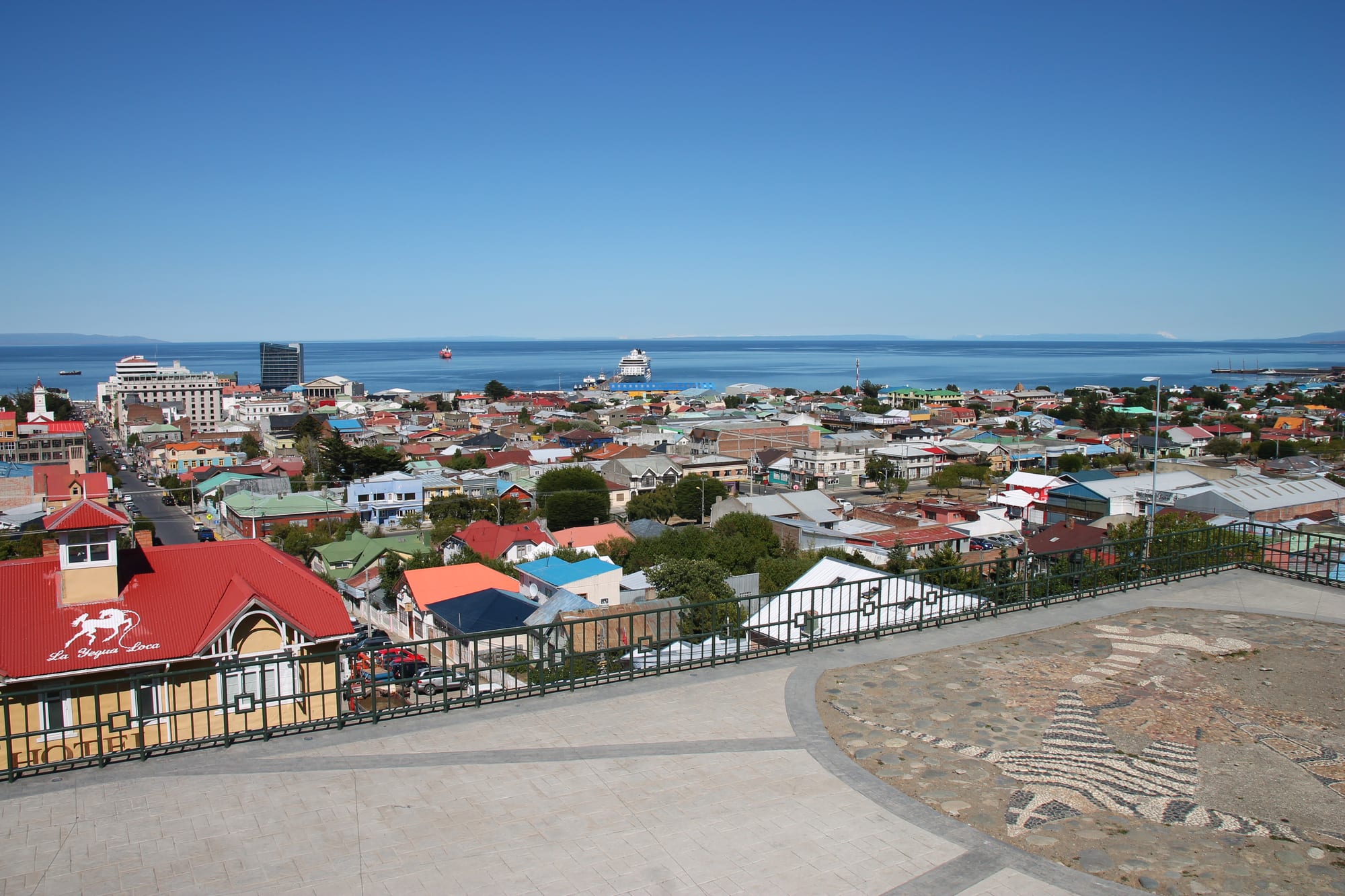
Colourful metal roofs of Punta Arenas spreading down to the blue Strait of Magellan, with a cruise ship moored offshore

Torres del Paine & Magallanes, Chile

Punta Arenas

Punta Arenas and the Strait of Magellan from the Cerro de la Cruz viewpoint. (Draceane / Wikimedia Commons · CC BY-SA 4.0)

The capital of Chile's Magallanes region, on the Brunswick Peninsula facing the Strait of Magellan. Founded in 1848 as a penal colony to assert Chilean sovereignty over the strait, it grew rich on shipping, gold and sheep, and its wool-era mansions still line the main square. Today it is a free port, a regional capital and a gateway to Antarctica.

Neighbourhoods

  • Plaza Muñoz Gamero and the centre
    • First-time visitors
    • Historic district
    • Shopping

    The main square, with the Magellan monument at its centre, is ringed by the grand buildings of the wool era — the Sara Braun palace, the Club de la Unión, the cathedral and the regional government. Bories and Magallanes streets nearby form the shopping district, with restaurants, outdoor shops and most hotels close by.

    Open in Maps
  • The Costanera
    • Sea views
    • Walking

    The coastal avenue along the Strait of Magellan, with views across the water and cormorants and other seabirds on the shore. It is one of the city's main walks.

    Open in Maps
  • Cerro de la Cruz and the hillside
    • Views
    • Quiet and residential

    Residential streets climb the slope behind the centre to the Cerro de la Cruz viewpoint, about ten minutes' walk from the square, which looks over the coloured metal roofs to the strait and Tierra del Fuego beyond.

    Open in Maps
  • Avenida Bulnes and the north
    • Cemetery and museums
    • Shopping

    The long avenue running north from the centre passes the cemetery, the Salesian museum and the Museo del Recuerdo, and continues to the Zona Franca duty-free mall.

    Open in Maps

Things to do

Famous landmarks

  • Plaza Muñoz Gamerolandmark

    The main square, a green space in the middle of the city with a statue of Magellan at its centre; local legend says that whoever kisses the foot of the statue will return to the city.

    Open in Maps
  • Palacio Sara Braunlandmark

    A grand neoclassical mansion on the north side of the square, built between 1895 and 1905 for Sara Braun, widow of José Nogueira, now a national monument housing the Club de la Unión and a hotel.

    Open in Maps
  • Cemetery of Punta Arenaslandmark

    The city cemetery on Avenida Bulnes, known for its shaped trees and the grand mausoleums of the pioneer families, declared a national monument in 2012.

    Open in Maps
  • Cerro de la Cruzviewpoint

    A hillside viewpoint a short walk from the main square, with a panorama over the city's roofs and the Strait of Magellan.

    Open in Maps
  • Monumento al Ovejerolandmark

    A bronze sculpture of a shepherd, honouring a traditional profession of the Magellanic pampa.

    Open in Maps

Museums

  • Museo Regional de Magallanesmuseum

    The regional museum in the Braun-Menéndez Palace, a national monument, with collections on the region's contemporary history.

    Open in Maps
  • Museo Salesiano Maggiorino Borgatellomuseum

    A museum founded by the Salesians in 1893 on Avenida Bulnes, with natural history collections, Selk'nam culture and material from Antarctica.

    Open in Maps
  • Museo Nao Victoriamuseum

    A private maritime museum north of the city, opened in 2011, with full-size replicas of Magellan's Nao Victoria, Shackleton's lifeboat James Caird and the schooner Ancud, built with traditional techniques.

    Open in Maps
  • Museo Naval y Marítimomuseum

    The naval and maritime museum on Pedro Montt, with a historical collection of the Chilean armed forces during the colonisation of Magallanes and Chilean Antarctica.

    Open in Maps
  • Museo del Recuerdomuseum

    The University of Magallanes' open-air museum, with eight heritage wooden buildings, about 40 historic vehicles and machinery from sheep farming and oil production.

    Open in Maps

Parks and the waterfront

  • Costanera del Estrechotrail

    The coastal avenue along the strait, good for a walk with views over the water and its seabirds.

    Open in Maps
  • Parque María Behetypark

    One of the city's main green spaces, with picnic areas and a lake used for canoes and kayaks in summer and skating when frozen in winter.

    Open in Maps
  • Magallanes National Reservepark

    A forested reserve 5 km west of the city, created in 1932 to protect the watershed that supplies its drinking water, with walking trails.

    Open in Maps

Short trips from the city

  • Isla Magdalena penguin colonypark

    Magdalena and Marta islands in the Strait of Magellan, about 35 km north-east of the city, form the Los Pingüinos Natural Monument, home to the largest penguin colonies in southern Chile and visited by boat in summer.

    Open in Maps
  • Fuerte Bulneslandmark

    A reconstruction of the fort founded in 1843 to claim the strait for Chile, rebuilt between 1941 and 1943 with its church, jail and powder magazine, and a national monument since 1968.

    Open in Maps
  • Puerto del Hambrelandmark

    The site of Spain's doomed 1584 settlement of Ciudad del Rey Don Felipe, known as Port Famine after its colonists starved; a monument nearby marks what is sometimes considered the geographical centre of Chile.

    Open in Maps

Seasonal events

  • Carnaval de InviernoJuly

    The winter carnival, celebrated in the depths of the southern winter with parades, music and colourful costumes.

Eat and drink

Long-standing places and food districts in Punta Arenas. Hours, ratings and directions come from your maps app, always current.

Punta Arenas classics

  • Centolla (southern king crab)restaurant

    The region's prized seafood, served in many of the city's restaurants alongside centollón, sea urchins, mussels and southern hake.

    Open in Maps
  • Patagonian lambrestaurant

    Cordero magallánico, lamb raised on the steppe and roasted beside an open fire, is the city's signature meat.

    Open in Maps

Food districts and markets

  • Restaurants around Plaza Muñoz Gameroneighborhood

    The square and the streets around it, Bories and Magallanes above all, hold restaurants, cafés and tea rooms in the city centre.

    Open in Maps
  • The public marketmarket

    A public market and craft centre in the city, alongside a small downtown feria of souvenirs such as calafate syrup.

    Open in Maps

Experience Punta Arenas

History

Ferdinand Magellan sailed past the site in 1520, and the English navigator John Narborough, on his voyage of 1669–1671, described a low point with a few trees that he called Sandy Point, the origin of the Spanish name Punta Arenas. Spain tried to control the strait with settlements in 1584, Nombre de Jesús and Ciudad del Rey Don Felipe, but both failed; the second became known as Port Famine after its colonists starved. In 1843 Chile sent the schooner Ancud to build Fuerte Bulnes on the strait, and in 1848 the governor José de los Santos Mardones moved the settlement to a better site on the Las Minas river and named it Punta Arenas.

The early town was a penal colony and a punishment posting for soldiers. In 1851 a prisoners' mutiny killed Governor Muñoz Gamero, and in 1877 the artillerymen's mutiny destroyed much of the town. Land grants from 1867 drew settlers, first British and then, from 1906, more Croatians than any other group, attracted by a gold rush, sheep farming and the shipping trade. Between about 1890 and 1940 the Sociedad Explotadora de Tierra del Fuego, founded in 1893 by Sara Braun and her brother Mauricio, built a sheep empire of millions of animals from its headquarters here, and the port served steamships as a coaling station. The same boom brought the destruction of the Selk'nam people, in which later historians have examined the role of the leading ranching families.

The opening of the Panama Canal in 1914 reduced the strait's importance for shipping. The city was renamed Magallanes in 1927 but took back its old name in 1938. It became a free port in 1977, and oil, tourism and Antarctic logistics have sustained it since.

Culture & Customs

Punta Arenas is a city of immigrants. It is said to have the largest proportion of people of Croatian descent anywhere outside the former Yugoslavia, and Croatian names remain on shops, streets and buildings, alongside the largest share of people of British descent in Chile and families of Spanish, German, Italian, Swiss and Irish origin. Sindhi merchants have arrived since the early 1900s, and the city has the southernmost Hindu temple in the world.

The wool barons left a city of grand buildings: the palaces around Plaza Muñoz Gamero, the Braun-Menéndez mansion that houses the regional museum, and the cemetery whose shaped trees and family mausoleums have seen it ranked by CNN among the most beautiful cemeteries in the world. The city was long nicknamed the "city of red roofs" for its painted metal roofs, which have become multicoloured since about 1970. Local legends promise a return to anyone who kisses the foot of the Magellan statue or eats calafate berries.

Cultural life includes the municipal theatre, a cluster of museums and the winter carnival each July. The University of Magallanes, founded in 1981, anchors academic life and publishes the journal Magallania. Gabriel Boric, President of Chile from 2022 to 2026, was born here, as was the historian Mateo Martinic.

Daily Life

The city had about 132,000 people at the 2024 census, which makes it the largest city south of the 46th parallel and the southernmost city of more than 100,000 people in the world. About 6 per cent of residents are immigrants, most from elsewhere in South America.

The economy has diversified since the wool era. Chile's main oil reserves are nearby, sheep and cattle farming still matter, and tourism has grown steadily, with cruise ships along the fjords and voyages to Antarctica. The free-trade zone, the Zona Franca, is a large duty-free shopping centre, and the city is a logistics base for Antarctic science, with charter flights to the ice.

Daily life is shaped by wind, light and distance. Gusts are strongest in summer, when days stretch late into the evening, while winter brings snow and short days. Residents are exposed to strong ultraviolet light because of the thinning ozone layer overhead. The road to the rest of Chile runs through Argentina, and the city keeps its own time zone, on summer time all year round since 2017.

Food

Punta Arenas shares the cooking of Magallanes. Cordero magallánico, lamb raised on the steppe and roasted for hours beside an open fire, is the centrepiece of family gatherings. The cold waters of the strait and channels supply centolla, the southern king crab, its smaller cousin centollón, sea urchins, mussels and southern hake, which appear on the menus of the city's restaurants.

Immigrants shaped the table too. Croatian and German settlers brought cakes and pastries, and afternoon tea with cakes is a Punta Arenas habit. Calafate, the dark blue berry of a thorny Patagonian shrub, flavours ice cream, jam and a syrup used for the calafate sour, a local variant of the pisco sour; legend says whoever eats the berry will return.

Beer has long been brewed in the city, which claims the southernmost brewery in the world, and local craft labels have joined it. Mate is common in homes, as across the region.

Planning tools

Budget

Punta Arenas is one of the more expensive cities in Chile, though cheaper than staying inside Torres del Paine. It has hostels and budget restaurants as well as large hotels, and as a free port it has duty-free shopping. Penguin boat trips, Antarctic flights and cruises are the big costs.

Daily Budget Midrange
USD 150–280 (hotel, restaurant dinners with king crab or lamb, museum entries, a penguin trip or a hire car)
Daily Budget Shoestring
USD 55–90 (hostel bed, supermarket food and set lunches, city buses and colectivos)

Book penguin trips and summer flights early; the city's museums, viewpoints and waterfront walks cost little or nothing.

Best Time to Visit

October to April is the main season, when the penguins are on Isla Magdalena and the boats run, days are long and Antarctic voyages depart; cruise ships call most often from December to March. Summer is also the windiest time. Winter is cold, snowy and dark but calmer, and brings the July winter carnival.

Suggested Number of Days

Two or three days cover the city itself. Allow four or five to add boat or road trips along the strait. Wind can delay boats and flights, so a spare day helps, and many visitors also use the city as a stop on the way to Puerto Natales.

First Visit
2–3 days
With Surroundings
4–5 days

Transportation

The centre is compact and walkable. City buses run on four lines from downtown to the suburbs, and taxis, minibuses and shared colectivos cover longer journeys. There is no single bus terminal for long-distance services; each company has its own office, with frequent buses to Puerto Natales, about three hours away. Ferries cross the strait to Porvenir on Tierra del Fuego and sail less often to Puerto Williams.

Reaching the rest of Chile by road means passing through Argentina, so carry a passport for overland trips.

Airport & Station Connections

Presidente Carlos Ibáñez del Campo International Airport, shared with the Chilean Air Force, is about 20 km north of the city, with flights from Santiago and southern Chile and charter flights to Antarctica. Buses run from Puerto Natales and, with a ferry crossing, from Ushuaia, and cruise ships call often, especially from December to March.

Walkability

The centre is compact and pleasant on foot, with the square, the museums, the Costanera and the Cerro de la Cruz viewpoint all close together. The wind is the main obstacle: gusts can reach 130 km/h, and the city has put up ropes between buildings downtown to help pedestrians. The cemetery is a longer walk north along Avenida Bulnes.

Safety

Chile is one of the safer countries in South America, but petty and opportunistic crime has risen, especially in Santiago and Valparaíso — pickpocketing, bag-snatching, phone theft, and distraction scams in tourist areas, markets, and on transport. Crime is low in Punta Arenas; the hazards are the wind, cold water and rough crossings on the strait, and strong ultraviolet light, as the city has been affected directly by the thinning of the ozone layer since the 1980s.

Use sunscreen and sunglasses even on cool days, dress for wind and cold, and expect seasickness on boat trips in rough weather. Check current official travel advice before travelling.

Climate

A subpolar oceanic climate with temperatures that change little through the year, moderated by the sea. Rainfall is low, about 380 mm a year, because of the rain shadow of the Andes, and highest in April and May; snow falls from June to September. Wind is the defining feature, strongest in summer.

Summer
December to February is summer — cool and windy, with January highs around 14°C and very long days
Winter
June to August is cold, with July lows near −1°C, snow and short days

Local Customs

Punta Arenas is proud of its pioneer heritage: Croatian names are on shops, streets and buildings, alongside British, Spanish, German, Italian and Swiss roots and a long-established Sindhi community with the world's southernmost Hindu temple. Tea with cakes is a local habit. The city and region keep their own time zone, on summer time all year.

Fruit, vegetables and animal products may not be brought into Chile from Argentina; declare food at the border, and be patient with wind delays to ferries and flights.

Common Payment Methods

The currency is the Chilean peso (CLP). Cards are widely accepted, and the city has many banks and cash machines. Exchange bureaux downtown change US dollars, euros and Argentine pesos. The Zona Franca duty-free zone sells imported goods tax-free.